Showing 76 items matching "concrete blocks"
-
 Kyneton RSL Sub Branch
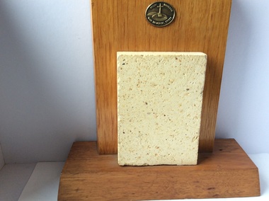
Mt Macedon War Memorial Cross tile, Original completed in 1933, additions made 1941 and restoration 1995
The original idea to create a monument was conceived by William Cameron. The monument was first constructed of cement block tiles and was a memorial to all those who served in WW1. Later gates were added to the precinct in memory of those who served in WW2. Restoration of the Memorial took place in 1995, with the original tiles being replaced by replaced by re-inforced concrete. Mt Macedon Memorial Cross is a significant War Memorial in the district. ANZAC Day dawn service is held at the Mt Macedon Cross, it is an impressive setting.Glazed precast cement block coloured to resemble sandstone, mounted on wooden stand. Centre front is a metal plate inscribed : Mt Macedon War Memorial Cross.On the back of the stand is a printed description of the construction history of the Mt Macedon Memorial Cross. No 77, on white sticker ( previous cataloguing number) memorial -
 Buninyong & District Historical Society
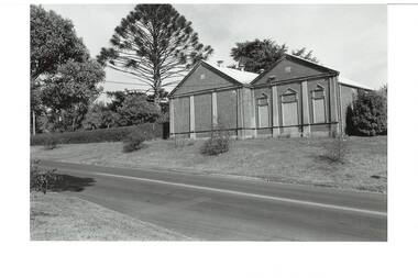
Photograph - B/W photograph, Buninyong Masonic Lodge, 1993
The Buninyong Masonic Lodge was originaly formed in 1858. This brick building is the second hall on the site.Third oldest Masonic Lodge in Ballarat area, example of C20th public building.Black and White photograph of the Buninyong Masonic Lodge, double-fronted brick building, decorative concrete low-relief pillars, door and windows blocked. Also showing nature strip and roadway in Warrenheip Streetbuninyong, warrenheip st., masons., hall, building, streetscape -
 Kew Historical Society Inc
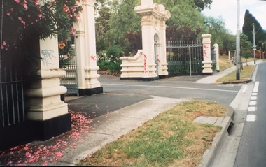
Photograph - Gates, Victoria Park, 1988
The Kew Asylum Entrance Gateway and an adjacent gate lodge were built at the Princess Street entrance in 1873.1 The imposing sandstone pillars and cast-iron gates impressed upon visitors the therapeutic and civilising vision of the asylum. The entrance opened onto a tree-lined drive (now known as Main Drive) which culminated in an elliptical carriageway in front of the main building. (Heritage Council of Victoria)Colour photographic positive of the former Kew Asylum Gates which were relocated in 1942 to Victoria Park in High Street, Kew. The gates were listed by Heritage Victoria in 2020. The citation reads: "The Former Kew Asylum Entrance Gateway consists of two 4.5 metre sandstone gate piers on bluestone bases on either side of a 5.5 metre vehicle entrance set back from the High Street pavement. The 1870s gate piers are of Barrabool sandstone and repairs during 2015-16 were undertaken with sandstone from English Town, Tasmania. The gate piers are highly decorative and feature oculi, triglyphs, dentils, corbeling and other ornamental work. Each gate pier incorporates a pedestrian archway with a cast-iron pedestrian swing gate. Two curved sections of cast-iron palisade fencing on rusticated bluestone blocks extend from the outer edges of the piers to a set of shorter sandstone pillars on the High Street pavement. Straight sections of cast-iron fence extend 4.5 metres ending at two bluestone pillars. Garden beds have been created within the curved sections of fencing, bordered by concreted bluestone and planted with shrubs." (Heritage Council of Victoria)gates -- kew asylum, gates -- victoria park -- kew (vic.) -
 Parks Victoria - Point Hicks Lightstation
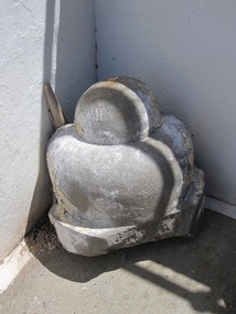
Corbel
In architecture a corbel serves a decorative as well as structural function as a solid piece of stone, wood or metal that is built into a wall and juts out like a bracket to carry a weight. The smoothly shaped corbel was formerly built into the external wall of the lighthouse facing the sea. It consists of two cupped, rounded forms, one bigger than the other, which are attached to a damaged flat base. Made of cast concrete, it is the same fabric as the lighthouse and shows evidence of white paint on its surface. An early architectural drawing of the tower shows the corbel as a projecting, decorative moulding underpinning the balcony floor associated with the auxiliary light. It indicates the original corbel was a much larger architectural feature which started as a solid rectangular block and terminated with a smaller block and then two tapering, rounded forms. Prepared in mid-1888, the architectural drawings for the lighthouse by Victorian Public Works Department architect, Frederick Hynes, were amended in 1888-89 to provide for an auxiliary light, which comprised an arched opening and door in the tower wall below the lantern room and small balcony. In the late nineteenth century all of Victoria’s lightstations installed a red auxiliary light to serve as a danger warning to mariners sailing too close to shoare. Existing lightstations, like Cape Otway, built a pavilion below their lighthouse facing out to sea, but newly constructed towers like Point Hicks and Split Point incorporated them into their designs. The efficacy of auxiliary lights became a controversial issue and all were discontinued on 1 January 1913. The Point Hicks balcony was removed from the face of the tower in 1971 after it was found to be badly rusted. This resulted in the complete removal of the corbel, from which the rounded moulding and part of the base survives. The auxiliary light and door were subsequently removed in 1975 and glass blocks now fill the opening. Cape Schanck Lightstation retains four cast iron brackets from its auxiliary light balcony which are currently stored in the lighthouse on the ground floor. No other architectural fabric associated with the auxiliary light has been identified at Point Hicks Lightstation. The fragment of corbel has first level contributory significance for its historic and architectural values as a relic of the auxiliary light and as an original moulding from the fabric of Victoria’s first concrete lighthouse.A masonary corbel. -
 Wodonga & District Historical Society Inc
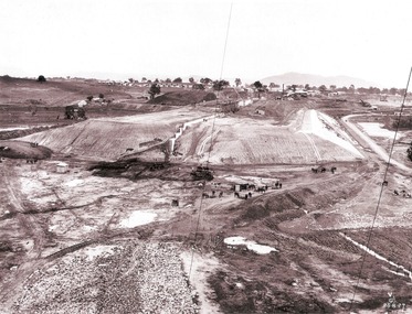
Album - Hume Reservoir Australia Album - Detail plan and explanation, Department of Public Works, N.S.W, 1927
This set of photos is from a leather bound album bearing the inscription "HUME RESERVOIR AUSTRALIA" plus 'The Rt. Hon. L. C. M. S. Amery, P. C., M .P.' all inscribed in gold. It was presented to The Rt. Hon. L. C. M. S. Amery, P. C., M. P, Secretary of State for Dominion Affairs on the occasion of his visit to the Hume Reservoir on 2nd November 1927. This album is of local and national significance as it documents the planning and development of the Hume Reservoir up to 1927. It was the largest water reservoir in the British Empire. The album records the pioneering engineering work that went into its construction.2. Detail Plan and Section. Starting from the New South Wales and there will be an earthen embankment 430 feet 6 inches long which is retained by the North Wing Wall. Then come the sluice section 284 feet 3 inches long, the spillway 720 feet long and the South Wing Wall, making a total length of 1,042 feet 6 inches of concrete wall. Beyond the South Wing Wall is earth embankment again to a length of 3,827 feet. The Full Supply Level is R.L.626.00 and allowance has been made for a surcharge of 9 feet. A road will run along the top of the dam at R.L.642.00. The sluice section contains seven offlets, the three nearest the north wing wall being 13 feet in diameter for hydro-electric purposes and the other four 9 feet in diameter for regulation purposes only. There are to be stony sluice gates on the upstream ends of the outlets and needle valves on the downstream ends. The shock of the discharged water will be taken by a stilling pool. Trash racks will protect the intake ends of the outlets. Next comes the spillway section, which is curved on the downstream face, and carried up to within 15 feet of the full supply level. Above that will be a series of piers between which will be the flood gates and on top of which the roadway will be carried. The gates will be 20 feet wide and 15 feet high and will be 29 in number. They will slide down the face of the wall when opened for the escape of the water. The investigation of the control of this cascade of water was made by means of a model and as a result the form of “bucket” or energy dissipater shown on the section of the spillway was decided upon. The earth embankment in Victoria is being constructed by the State Rivers and Water Supply Commission of Victoria who are the Constructing Authority for that State under the River Murray Waters Agreement. The core of the embankment is of concrete 6 feet wide at the base tapering to 2 feet at the top end and is reinforced with steel rods from the level of the decomposed rock upwards. On the downstream side, at about natural surface level, is a tunnel for drainage and inspection purposes. Above the tunnel is a vertical layer of large stones to drain any seepage to the tunnel. Against the core wall is packed selected material of as impervious a character as can be got locally and beyond that the bank is carefully built up in horizontal layers by means of horses and wheel scoops. The upstream slope is 3-to-1 hardening to 2½-to-1 at the top and the downstream slope is 2½-to-1 hardening to 2.07-to-1 at the top. The thrust of the upstream toe is taken by a mass of granite blocks, and this face is protected by concrete laid in situ. The width of the bank at base is 650 feet and at top 32 feet.hume reservoir australia, river murray waters scheme, hume weir diagrams, hume plan details -
 Wodonga & District Historical Society Inc
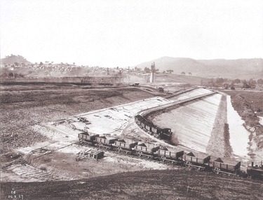
Album - Hume Reservoir Australia Album - Earth embankment on Victorian side from Top of Tail Tower Pillar, August 1927
This set of photos is from a leather bound album bearing the inscription "HUME RESERVOIR AUSTRALIA" plus 'The Rt. Hon. L. C. M. S. Amery, P. C., M .P.' all inscribed in gold. It was presented to The Rt. Hon. L. C. M. S. Amery, P. C., M. P, Secretary of State for Dominion Affairs on the occasion of his visit to the Hume Reservoir on 2nd November 1927. This album is of local and national significance as it documents the planning and development of the Hume Reservoir up to 1927. It was the largest water reservoir in the British Empire. The album records the pioneering engineering work that went into its construction.DEPARTMENT OF PUBLIC WORKS, N.S.W. RIVER MURRAY WATERS SCHEME. HUME RESERVOIR. 31. View from Top of Tail Tower Pillar - Earth Embankment, Victoria. This is a general view of the embankment which is being constructed by the Victorian Constructing Authority. The bank at its base is about 650 feet wide and it is about half its ultimate height. In the middle is the reinforced concrete core wall. At about the natural surface a tunnel for drainage and inspection purposes is built along the downstream side of the core wall but this cannot be seen. The Victorian workshops and township are located on the high ground beyond the embankment. The embankment curves round to the left at the side of the valley and will eventually block the gulley where the bushy tree stands. Access to one of the cuttings from which material is being got for the embankment is gained by means of this gulley at present. Part of another cutting may be seen on the right hand side at the back. August 1927.hume reservoir australia, river murray waters scheme, hume reservoir construction -
 Wodonga & District Historical Society Inc
Album - Hume Reservoir Australia Album - Concrete Slabs on embankment, August 1927
This set of photos is from a leather bound album bearing the inscription "HUME RESERVOIR AUSTRALIA" plus 'The Rt. Hon. L. C. M. S. Amery, P. C., M .P.' all inscribed in gold. It was presented to The Rt. Hon. L. C. M. S. Amery, P. C., M. P, Secretary of State for Dominion Affairs on the occasion of his visit to the Hume Reservoir on 2nd November 1927. This album is of local and national significance as it documents the planning and development of the Hume Reservoir up to 1927. It was the largest water reservoir in the British Empire. The album records the pioneering engineering work that went into its construction.DEPARTMENT OF PUBLIC WORKS, N.S.W. RIVER MURRAY WATERS SCHEME. HUME RESERVOIR. 33. Concrete Slabs on Embankment. The upstream face of the embankment is being protected from the effects of wave action by concrete slabs 12 inches thick laid in squares in situ. The thrust at the toe of the bank is taken care of by a body of granite blocks and spalls. Victoria. August 1927.hume reservoir australia, river murray waters scheme, hume reservoir construction -
 Lakes Entrance Historical Society
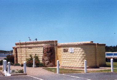
Photograph, Holding M, 1998c
... Colour photograph of the toilet block situated... block constructed of concrete bricks made locally, entrances ...Bricks for toilet block construction were made at Kimmells farm by Clyde Worseldine, Tambo Shire employee after WW2Colour photograph of the toilet block situated on the eastern wharf precinct, showing a public toilet block constructed of concrete bricks made locally, entrances faced with local stone. Lakes Entrance Victoriajetties, public facilities -
 Warrnambool and District Historical Society Inc.
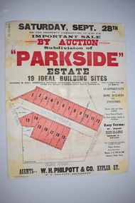
Work on paper - Original Document, H J Paynter, Advertisement "Parkside"Estate subdivision, Circa 1935
This sheet denotes an auction of land which is situated close to Albert Park on the northern part of Warrnambool. The area is complete now with homes which are a mixture of brick and concrete faced houses. The agent W H Philpott was operating in Warrnambool from the 1930's though to 1950'sThis item has local interest and significance as it records the sale of Warrnambool land.Large white paper sheet with black and red text. The auction details are at the top and down the righthand side with a map of the available blocks are coloured red and outlined in black.Parkside estate, W H Philpott & Co Kepler St , R V Philpott auctioneer,Solicitors J S Tait & son. Cramer Street, Nelson Street McConnell Street.warrnambool, mcconnell street warrnambool -
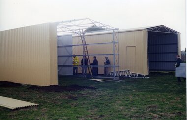 Ballarat Tramway Museum
Photograph - Colour Photograph/s - set of 18, Carolyn Dean, 6/05/2000 12:00:00 AM
Set of 18 photographs of the completion of the sheds and commencing on the house extensions at Bungaree over the period 6/5/00 to 24/6/00. All taken by Carolyn Dean. 6/5/00 1. Cladding the second shed 2. ditto 3. ditto 4. House being repainted and wheels storage 7/5/00 5. Fittings doors to first shed - trail fit 6. House block 7. Roof sheeting to 2nd shed 8. The two sheds 11/6/00 9. The two sheds complete with doors and flashings 10. House with sheds in background (photo used in July 2000 Fares Please! and 1999-2000 Annual Report) 11. ditto 12. House extensions - old shed demolished 13. Modifying pipe work 14. ditto 15. Old foundations 16. Mini mix delivering concrete 17. New slab over old 18. and extending front step.All have date and "Photo by Carolyn Dean" on rear.bungaree, sheds, house extensions -
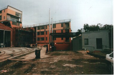 Melbourne Tram Museum
Photograph - Set of 9 Colour Print/s, Steven Altham, 27/02/2002 12:00:00 AM
Set of 9 colour prints of the re construction of the Hawthorn Tram Depot to the Watermark Apartments. All taken on 27-2-2002 .1 - View from Wallen Road with the track work relaid, new end wall on the original building and the facade for the 2nd depot being constructed. .2 - new facade to the original section of the depot with tracks. .3 - part of the new apartments .4 - From Power St looking between the original and new buildings. .5 - ditto .6 - ditto .7 - looking from Power St at the south end of the new block. .8 - view of trackwork and fan concreted in. .9 - ditto Colliers Jardine and Bovis Lend Lease signs in the photos.All have details of photograph on rear and photographers name.trams, tramways, watermark apartments, hawthorn depot, construction, tram depot -
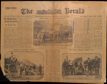 Melbourne Tram Museum
Newspaper, The Herald, "Five Million blocks to pave city streets - Big contracts begin", 17/06/1916 12:00:00 AM
Newspaper clipping, from The Herald, 17/6/1916, 2nd Edition - titled "Five Million blocks to pave city streets - Big contracts begin" about the repaving of St Kilda Road with wood blocks . has three photos of the work, using concrete foundations. Notes the future electric trams in the last paragraph.trams, tramways, cable trams, track, wood blocks, st kilda rd -
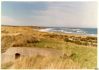 Flagstaff Hill Maritime Museum and Village
Photograph - Historical, Flagstaff Hill, Warrnambool Garrison Fortifications looking towards the Moyjil (Point Ritchie), 1970s
The photograph shows the location of the concrete, horseshoe shaped gun emplacement erected for the cannons. It is part of the Historic Precinct on Flagstaff Hill. The area was accessed either through the space between the Lighthouses (through the cottage grounds) or a service entrance, past the iron huts used by the Lands Department. This photograph, a print, is one of a set of five that show the site of Flagstaff Hill. It is presumed to have been taken by John Lindsay, Founding Director of Flagstaff Hill Maritime Museum and Village. One of the photographs in the set has the pencil inscription "Photo J Lindsay". It was taken in the early 1970s during the initial stages of the development of Flagstaff Hill as a Museum and Maritime Village. The photographs belonged to the donor's grandparents, who lived in the Warrnambool district of Allansford/Naringal. The photograph is a record of the site and surrounds of Flagstaff Hill Maritime Museum and Village before its development and opening in 1975. It shows the east side of the Surfside Holiday Park in its earlier days. The photograph is significant for recording the location and condition of the original concrete cannon emplacement on the Hill.Coloured photograph, glassy print, one of a set of five. Photograph shows the original site of one of the gun emplacements for the cannons, cannons Historical, looking towards the Moyjil, ,Point Ritchie and overlooking Lady Bay, Warrnambool. The horseshoe shaped concrete gun emplacement is in the foreground on the grassed slopes overlooking the Bay. The site and ablution block of the Surfside Holiday Park is centre right. The left shows the sore of Lady Bay with the cliffs of the Southern Ocean in the distance. The photograph's paper has the printer's watermark on the back. The early 1970s scene is presumed to have been photographed by John Lindsay, Warrnambool.Label on the back: "FIRST GUN EMPLACEMENT LOOKING TOWARDS THE HOPKINS / This is the original site of one of the cannons overlooking the Bay. Access to this area could be between the light-houses (throught the cottage grounds), or a service entrance - past the iron huts used by Lands Department."flagstaff hill, flagstaff hill maritime museum and village, warrnambool, maritime museum, maritime village, great ocean road, shipwreck coast, 1970s, photograph, gun emplacement, surfside holiday park, lady bay, hopkins river, flagstaff hill site, john lindsay, concrete gun emplacement, cannon emplacement, original emplacement -
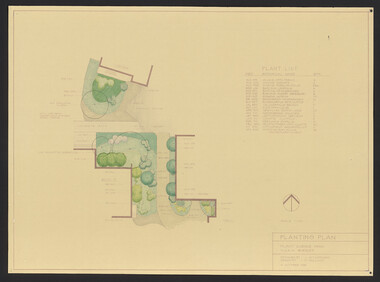 University of Melbourne, Burnley Campus Archives
Plan, Student Amenity Building (Citriodora) Courtyard, 1988-2000
Various plans for what is now known as the "Citriodora Courtyard." I copy tracing paper, 1 coloured original, 4 copies with additional notation 6 smaller copies with additional notation. (1) Planting Plan Plant Science Area V.C.A.H. Burnley designed by J. Hitchmough, drawn by S. Mullany 3 October 1988. (2) Student Amenity Quad Sketch Proposal by M. Green May '95. (3) Rough pencil design, New Design related to Horticultural pursuits of Burnley College. (4) Coloured, Proposed Citriodora Court Redevelopment. (5) 2 copies Citriodora Courtyard Presentation Concept Plan by Adrian Bonifacio. November 2000. (6) Landscape Graphics II Assoc. Diploma in Horticulture (Amenity) Assignment 2 - Planting Plan May 1988. (7) Laminated, Preliminary Plan 2 of 4 Citriodora Lawn Burnley by Kate Szmal B.A.S.H. (8) Laminated, Preliminary Plan Student Amenity Building Courtyard V.C.A.H. Burnley by Caroline Lodge. (9) 1 tracing paper and 1 paper copy University of Melbourne Burnley College Student Amenity Building Courtyard 19.8.99. (10) Setout Plan, Planting Plan & Surface Finishes, Details Courtyard & Entrance, ACM Landscape Architecture: Concrete Paving Topsoil, Mulch - notes. "Phil Tulk," handwritten on reverse. (11) Laminated, V.C.A.H. Preliminary Plan p3 of 5 Project No 1 Student Amenity Building Courtyard by K. Watson 15-8-95. (12) Citriodora Courtyard Redevelopment Concept Plan by Judy Brookes November 2000. 2 copies of Drawing 1 of 2, 1 copy Drawing 2 of 2. (13) Proposed Outdoor Eating Area Student Amenities Block: Scheme 1 pp 2-5 of 5, 16.10.96. Scheme 2 pp 3-5 of 5, 16.10.96. Scheme 8 3 copies p1 of 2, 2 copies p2 of 2, 23.6.97, Paving Types p1 of 1, 30.9.99, handwritten on reverse,"to Phil from Nicki." (14) 2 copies Entry from Rear Car Park Paving Plan. (15) Plan by Margaret Kitching 8.8.90. citriodora courtyard, vcah, centenary courtyard, plant science area, k. watson, s. mullaney, j. hitchmough, judy brookes, kate szmal -
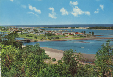 Lakes Entrance Historical Society
Postcard - Views of Lakes Entrance c1970, John Engelander and Co Melbourne, 1970 c
Princes Highway to town showing concrete bridge over North Arm . Also identical postcard with message on back in Spares boxColour postcard of view from Princes Highway to town showing concrete bridge over North Arm old toilet block opposite road to Bullock Island, Club Spit being formed, Hill 60 visible on outer barrier hummocks Lakes Entrance Victoriaroads and streets, township, waterways -
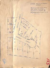 Ringwood and District Historical Society
Map, Subdivision Plan - House and 13 residential allotments fronting Fremont Street Ringwood, Vic., and George Street (later Tudor Court), Heathmont, Vic. - Undated, circa 1922
Hand-drawn map on cardboard backing.Formed road with concrete kerbing. Water available to each block. No. of subdivision A139880 73/419. Part of Certificate of Title Vol 5323 Fol 539. Real estate sales notations on some allotments include price. Heading also includes address and phone number of H. Willis, Fremont Street Ringwood - WU6073.