Showing 102 items
matching concrete slab
-
 Tatura Irrigation & Wartime Camps Museum
Photograph, 20/11/1956
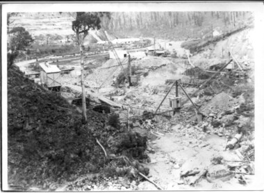
... under concrete slab at Tatura Waterworks storage / upright posts... black and white photograph. Big wash-away under concrete slab ...Taken by photographer for State Rivers and Water Supply Commission.Medium sized black and white photograph. Big wash-away under concrete slab at Tatura Waterworks storage / upright posts bottom right corner / sandbags and petrol drum above water line left of centre / water left of bankvictorian state rivers and supply commission, tatura waterworks, tatura waterworks trust -
Glenelg Shire Council Cultural Collection
Photograph - Photograph - Main Breakwater construction, Portland, n.d
... Black & white photo. Concrete slabs, workmen preparing reo.... Concrete slabs, workmen preparing reo. for more slabs. Spade ...Port of Portland Authority Archivesport of portland archives, main breakwater, construction, portland harbour, harbour development -
Tatura Irrigation & Wartime Camps Museum
Photograph, 20/11/1956
... under concrete slab at Tatura Waterworks storage / Sheets... black and white photograph. Big wash-away under concrete slab ...Taken by photographer for State Rivers and Water Supply Commission.Medium sized black and white photograph. Big wash-away under concrete slab at Tatura Waterworks storage / Sheets of galvanised iron foreground on slab / bags of sand and petrol drum further along above water level / water on right / tree on horizon.victorian state rivers and supply commission, tatura waterworks, tatura waterworks trust -
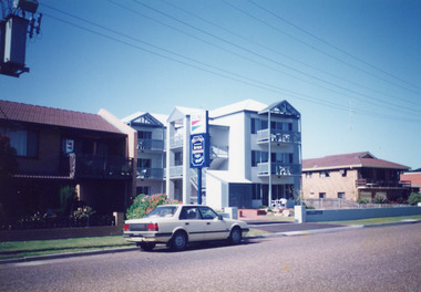 Lakes Entrance Regional Historical Society (operating as Lakes Entrance History Centre & Museum)
Photograph, 1992
... Parade. Modern style building, concrete slab construction, each... on Marine Parade. Modern style building, concrete slab construction ...Apartments opened for 1991 / 1992 seasonColour photograph of Bellevue Apartments, built on Marine Parade. Modern style building, concrete slab construction, each unit having own balcony. Section of Lakeside Motel seen on left, Hybiscus Motel on right. Car on street at front. Lakes Entrance Victoriahotels, architecture, transport -
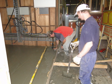 Ballarat Tramway Museum
Photograph - Digital image Set of 2, Peter Waugh, 12/06/2014 12:00:00 AM
... Mong and ?? screeding off the concrete slab. 6029.2 - ditto... Mong and ?? screeding off the concrete slab. 6029.2 - ditto ...Series of two digital photos of the reconstruction of the sub-station Ballarat Tramway Museum - 12/6/2014 with the concrete being poured on 12-6-14 by Peter Waugh. 6029.1 - Paul Mong and ?? screeding off the concrete slab. 6029.2 - ditto with the isolating transformer in the background.Photo by Peter Waugh, collected for reference purposestrams, tramways, btm, substation, depot, reconstruction -
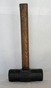 Orbost & District Historical Society
sledge hammer, first half 20th century
... . It can be used to remove concrete slabs, to drive heavy steel.... It can be used to remove concrete slabs, to drive heavy steel ...A sledge hammer is generally wielded with both hands and is used for driving wedges and posts and for other heavy work. It can be used to remove concrete slabs, to drive heavy steel bolts into concrete, to hammer large stakes as well as for demolition.This item was a common tool used by farmers or blacksmiths.A large flat hammer with a wooden handle.Underneath hammer - 10hammer sledge-hammer tool -
Glenelg Shire Council Cultural Collection
Postcard - Postcard - Portland, Victoria, n.d
... , granite obelisk on square base set on concrete slab, surrounded... on concrete slab, surrounded by post and chain fence, bronze plaque ...Black and white photo postcard. Henty's landing memorial, granite obelisk on square base set on concrete slab, surrounded by post and chain fence, bronze plaque. Photo taken looking east across harbour memorial in foreground, Henty Beach, Railway Pier, and Ocean Pier in background.Front: HENTY'S LANDING MEMORIAL, PORTLAND' - black italic print, bottom edgehenty, portland, memorial, portland harbour, seafront -
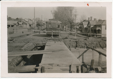 Ballarat Tramway Museum
Photograph - Digital image, Wal Jack, 19/06/1955 12:00:00 AM
... concrete slabs for tram track placed across new box girders, Barkly... "SEC Ballarat No. 35 east of creek, No. 32 concrete slabs ...Yields information the reconstruction of the Canadian Creek Bridge in 1955.Digital image from the Wal Jack Ballarat Album of No. 32 at Canadian Creek bridge in Barkly St, Mt Pleasant during the reconstruction of the bridge. Shows the new concrete base for the track in position. Photo dated 19-6-55 and shows the reconstruction work in progress. Tram was isolated to enable the service in Barkly St during the reconstruction of the Canadian Creek bridge during June-July 1955, see Reg Item 5155, 5157 as well and 5301, 5302 and 5305 and 7735. See image i2 for rear of photograph. See image i3 for hi res scan of print. See image i4 for hi res scan of negativeOn rear in ink "SEC Ballarat No. 35 east of creek, No. 32 concrete slabs for tram track placed across new box girders, Barkly St Ballarat East 19-6-55." In top right hand corner is Wal Jack stamp with number T179 written in.trams, tramways, mt pleasant, canadian creek, barkly st, bridges, tram 32 -
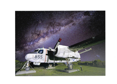 National Vietnam Veterans Museum (NVVM)
Photograph - Framed image of Gruman Tracker on site, Graeme Lawry, July 2024
... to concrete slabs with night sky in background. Image shows one side...-framed photograph of pale grey airplane chained to concrete slabs ...This image of the Grumman Tracker in front of the museum was taken by Graeme Lawry in July 2024 and presented to NVVM by the Phillip Island Camera Club in appreciation of their being able to use our meeting room gratis throughout the year.White-framed photograph of pale grey airplane chained to concrete slabs with night sky in background. Image shows one side of the aircraft, wing and propellor. The plane bears the number 855 in black under the windows, plus red and black vertical stripes. RAAF symbol of red kangaroo in blue circle is on the tail.aircraft, grumman tracker, pi camera club, lawry, graeme lawry, nvvm -
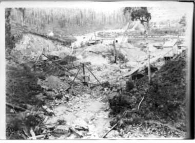
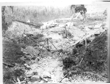
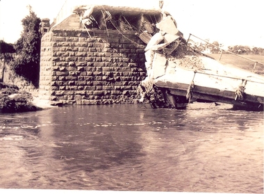 Federation University Historical Collection
Photograph - Photographs, Richard Vincent, Washed Away Bridge at Garibaldi, c1933
... at Garibaldi in the Buninyong Shire. The concrete slabs were still... at Garibaldi in the Buninyong Shire. The concrete slabs were still ...Newspaper clipping documents deputations to the Minister of Public Works for grants to be made available for repairs to bridges and roads damaged by heavy flooding in 1933, in particular, the replacement of a stone and concrete bridge over the Leigh River at Garibaldi in the Buninyong Shire. The concrete slabs were still in the water in the 1960s/70s or even later. Three black and white photographs showing flood damage to the bridge over the Leigh River at Garibaldi, plus a photocopy of a newspaper clipping from The Argus December 1933 describing the extent of the flood damage. .1) shows blue stone buttress and collapsed bridge/road. .2) mirror image of above .3) unknown man waling an a girder of the Garibaldi bridge .4) photocopy of newspaper clipping about flood damage from The Argus December 1933Damage by Floods: Bridges washed away (The Argus December 1933)leigh river, garibaldi, buninyong shire, richard vincent, garibaldi bridge -
 Kiewa Valley Historical Society
Black and white photograph, Early construction of Junction Dam Wall, c1940
... concrete slab buttress...., 1944. Type of construction: reinforced concrete slab buttress ...In December of 1939 the excavation of a diversion tunnel was commenced to divert water from the East Kiewa River to allow construction of the dam wall. This was completed in February 1940. Lewis Construction Co. had the contract with excavation starting in February and the first batch of concrete placed in September. In 1942 the S.E.C. took over the construction and the wall was completed in March, 1944. Type of construction: reinforced concrete slab buttress.Of historical importance in the Kiewa area as it shows the form work and preparation necessary before the pouring of concrete for the first dam in the hydro electric scheme. The destruction caused by the 1939 bushfires is also evident in the upper left hand corner.A black and white photograph of the early construction of Junction Dam wall viewed from downstreamOn back of photograph (left hand upper corner) Junction Dam 4-4-81 Dam viewed from downstream 352 Time to use for correct Exp. 40 secjunction dam, bogong, secv -
 Kiewa Valley Historical Society
Black and white photo of Junction Dam wall under construction, c1940
... : Reinforced concrete, slab buttress.... in February and the first batch of concrete placed in September ...In December of 1939 the excavation of a diversion tunnel was commenced to divert water from the East Kiewa River to allow construction of the dam wall. This was completed in February, 1940. Lewis Construction Company had the contract with excavation starting in February and the first batch of concrete placed in September. In 1942 the SECV took over the construction and the wall was completed in March, 1944. Type of construction: Reinforced concrete, slab buttress.Of historical importance in the Kiewa area as it shows the form work and preparation necessary before the pouring of concrete for the first dam in the hydro electric scheme. The destruction caused by the 1939 bushfires is also evident in the upper left hand cornerBlack and white photo, early construction of Junction Dam Wall, viewed from downstreamOn back of photo (left hand upper corner) Junction Dam 5-4-81 Dam viewed from downstream. 352 Time to use for correct exp. 40 sec.bogong, junction dam, secv -
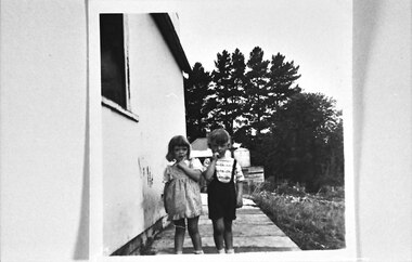 Southern Sherbrooke Historical Society Inc.
Rex and Kay Breen, Church Road, Menzies Creek
... Photo shows 2 children aged about 5, standing on a concrete...Photo shows 2 children aged about 5, standing on a concrete ...Photo shows 2 children aged about 5, standing on a concrete slab path beside a fibro-cement house. Kay Breen is wearing a gingham pinafore over a short-sleeved blouse. Rex Breen is wearing dark shorts with braces over a top with some sort of striped pattern. Behind them is another house with a circular water tank on a wooden stand. In the background there are tall pine trees. -
 Kiewa Valley Historical Society
Photograph of Bogong Dam Wall Construction - 2 identical photos, c1940
... : reinforced concrete, slab buttress.... in the same month, with the first batch of concrete placed ...Excavation of a diversion tunnel was commenced in 1939 to divert water from the East Kiewa River to allow construction of the dam wall. This was completed in February 1940 and excavation for the dam wall commenced in the same month, with the first batch of concrete placed in September. Lewis construction Company had the contract, but the S.E.C. took over construction in March 1942 and the dam was completed in March 1944. Type of construction: reinforced concrete, slab buttress.Importance in the Kiewa area as it shows the formwork and preparation necessary before the pouring of concrete for the first dam in the Kiewa Hydro Electric SchemeBlack and white photos (2 identical) of early construction of Junction Dam wall, viewed from downstream.Back of photo, upper right hand corner: No. 1 - Construction of Bogong Dam Wall (written in pencil) No. 2 - Same as one (written in pencil)construction, dam wall, excavation, bogong, secv -
Federation University Historical Collection
Photograph - Black and White, Launch of the University of Ballarat IT Centre and Technology Park, 1995, 22/02/1995
... on a concrete slab with initial building construction visible. Left... and Technology Park. They stand on a concrete slab with initial building ...University of Ballarat is a predecessor institution of Federation University Australia. Five me stand around a plaque on the occasion of the launch of the University of Ballarat IT Centre and Technology Park. They stand on a concrete slab with initial building construction visible. Left to right: Bruce Clark (Ballarat City Commissioner), Hon. Roger Hallam MLS (Minister for Regional Development), John Blight (ISSC General Manager), Professor Geoffrey Blainey (University of Ballarat Chancellor), Professor David James (University of Ballarat David James.ballarat technology park, southern region data centre, roger m. hallam, university of ballarat technology park, federation university technology park, it centre, bruce clark, john bligh, geoffrey blainey, david james -
Bendigo Historical Society Inc.
Newspaper - OLD VIOLET SHAFT - THE OLD VIOLET STREET MINE
... in the shaft, on top of the concrete slab. There was still the concern... dumped in the shaft, on top of the concrete slab. There was still ...Newspaper article titled 'Volcano' gives the Mines Department Problem. Bendigo Advertiser dated Friday, May 12, 1967. Mine was still burning and the ground had subsided four feet more. It would be a matter of waiting until the smoke diminished and how far the ground was going to subside. Until then it would be useless to do anything. Sawdust had been dumped in the shaft, on top of the concrete slab. There was still the concern for the local children.newspaper, bendigo advertiser, old violet shaft, old violet shaft, the old violet street mine, bendigo advertiser friday may 12 1967, mines department, mr frank vincent, lands department, senior constable p meaney, cr r f turner, violet street state school, mr a marshall, mr f turner, p hopley -
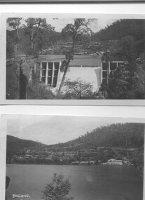 Kiewa Valley Historical Society
Two black and white photos, Photo downstream view of Junction Dam Wall and photo of Bogong Village and Lake Guy, c1950
... , 1940 and completed in March 1944. Type - reinforced concrete... and completed in March 1944. Type - reinforced concrete slab ...Photo No. 1 - Junction Dam wall was commenced in February, 1940 and completed in March 1944. Type - reinforced concrete slab and buttress. Height 25.9m, and crest length 121.9m. Lewis Construction company had the original contract, but was replaced by the State Electricity Commission in 1942. Photo No. 2 - Bogong Village was the first village built to house workers and their families working on the Hydro electric scheme. Construction commenced 1940. The single men's quarters are slightly right of centre on the foreshore. Lake Guy was named after a former resident engineer.Shows the type of terrain where the village is located resulting in the tiered layout that was necessary in order to erect housing.set of 2 black and white photos - Photo No. 1 - downstream view of Junction Dam Wall Photo No. 2 - Lake Guy and Bogong Village. Both are on photographic paperPhoto No. 1 - Upper right hand corner, back of photo, handwritten in ink or biro, Bogong 1950 Photo No. 2 - Left lower corner, front of photo in white, Bogong.bogong village, lake guy, secv -
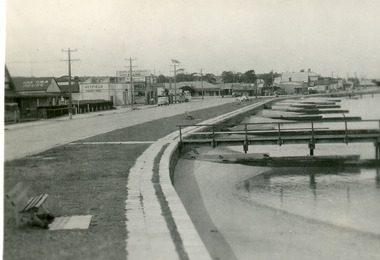 Lakes Entrance Regional Historical Society (operating as Lakes Entrance History Centre & Museum)
Postcard - Lakes Entrance, Bulmer H D, 1940c
... of concrete slabs. Across the highway from left to right is Kia-Ora... at edge of lake at walking path of concrete slabs. Across ...From a wallet of minitiature postcards published by Bulmer for sale to tourists. Also enlarged black and white copy 18.5 x 25 cm,Black and white mini postcard of Esplanade, showing timber groynes for sand control at edge of lake at walking path of concrete slabs. Across the highway from left to right is Kia-Ora House, Heyfield House, Coate Bros Garage, Robin Hood Inn, Vizes Cafe, Vic Carstairs, Miss Brown's (subagent for Statebank), Methodist Church, Bellevue Guest House, Police Station, Maranui Guest House, Glenara Guest House. Lakes Entrance Victoriatownship, waterfront, accommodation -
Glenelg Shire Council Cultural Collection
Photograph - Photograph - Main Breakwater construction, Portland, 05/06/1659
... decking. Stacks of concrete piles and slabs, various vehicles... for concrete decking. Stacks of concrete piles and slabs, various ...Port of Portland Authority archivesFront: 5/6/59- Pencil Back: 5/6/59 - Pencilport of portland archives, main breakwater, construction, harbour development, site -
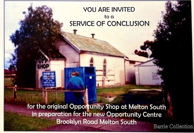 Melton City Libraries
Flyer, Melton South Uniting Church Opportunity Centre, 2016
... were demolished allowing the concrete slab to be laid... at the rear of the timber church were demolished allowing the concrete ...The Opportunity Shop – Established 1975 by Edna Barrie 1992 In 1985 the need for more shop space became apparent. Les [Bone] had plans drawn up (Surv 12/8/84) and approved by the Melton shire Council for a storeroom extension (17.800 x 9500) 1986 the small ancillary rooms at the rear of the timber church were demolished allowing the concrete slab to be laid. The building was completed in 1987. By the early 1900s the old timber Church had deteriorated, this lead to it being demolished in 2/11/1993. It was replaced with a new building containing a Pastoral Office, a meeting room and a furniture and homeware section. It was dedicated by Rev Ian Hickingbotham at 11am Sunday 5th June 1994. Invites to the service of conclusion of the original Uniting Church Opportunity Centre and official opening to the new shop in Melton Southchurches, local identities -
Glenelg Shire Council Cultural Collection
Photograph - Photograph - Portland Harbour hoisting concrete slabs, n.d
... Black and white photo showing slabs of concrete with metal... Authority Archive Black and white photo showing slabs of concrete ...Port of Portland Authority Archive -
Glenelg Shire Council Cultural Collection
Photograph - Photograph - Main Breakwater construction, Portland, n.d
... for slabs to be put on top. Stacks concrete piles. Rows of wooden... of concrete piles & concrete ready for slabs to be put on top. Stacks ...Port of Portland Authority Archivesport of portland archives, main breakwater, construction, work site, write, barge, portland, harbour -
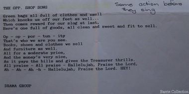 Melton City Libraries
Document, The opp. shop song, Unknown
... were demolished allowing the concrete slab to be laid... were demolished allowing the concrete slab to be laid ...SUMMARY – Uniting Church Op Shop Melton South Opportunity Shop – Brooklyn Road Melton South Est 1975 Former Methodist Church. The Opportunity Shop – Established 1975 by Edna Barrie 1992 Typed copy by Cath MacLean 2011 [Scots’ Presbyterian Church 1964] Additional information to the above summarised from Edna Barrie’s draft notes. Copied by Wendy Barrie January 2012, noting the information might be useful for future research. In 1985 the need for more shop space became apparent. Les [Bone] had plans drawn up (Surv 12/8/84) and approved by the Melton shire Council for a storeroom extension (17.800 x 9500) 1986 the small ancillary rooms at the rear of the timber church were demolished allowing the concrete slab to be laid. The building was completed in 1987. By the early 1990s the old timber Church had deteriorated, this lead to it being demolished in 2/11/1993. It was replaced with a new building containing a Pastoral Office, a meeting room and a furniture and homeware section. It was dedicated by Rev Ian Hickingbotham at 11am Sunday 5th June 1994. Service Awards were presented to 75 Opportunity Shop Volunteers by Rev Ian Hickingbotham. Funds have helped to pay for pastoral work, youth work and extra pastoral support. Lyrics for the Opportunity Shop which was located at the former Methodist Church. council, churches, local identities -
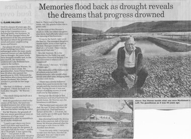 Halls Gap & Grampians Historical Society
Newspaper - B/W
... showing beneath the drying lake is the concrete slab of the new... the drying lake is the concrete slab of the new home Mr Warren ...Until the closure 40 years ago, the Myrtlebank Guesthouse near Halls Gap in the Grampians was a thriving family - run business. In 1962, all that changed when the government of the day purchased the land on which the guesthouse stood and some neighbouring farms and houses. For almost 40 Years, the remains of the buildings have been submered under the man made reservoir known as Lake Bellfield. Due to drought, the eater levels have dropped steadily and, in the past month, the memories underneath Lake Bellfield have come to the surface. Local resident Don warren 70, has been to have a look. His grandmother Anne Flower Warren, was 56 when she opened the guesthouse in 1916. Widowed, the year before after a horse kicked her farmer husband, Mrs Flower needed to provide for their large family. "She had 13 children - seven daughters. I think she built it to look after the girls," Mr Warren says, "The whole think was built on a 500 acre farm." With the guesthouse sited in the centre of the farm, the land was divided between two of her sons- Mr Warren's uncle working one side and his father taking the other. For Mr Warren, the grounds of the two-storey guesthouse were an extension of a huge rural playground in what he remembers as an idyllic childhood. "I used to get taken over there and I'd sit there and watch her make all the toast for the guests. It was quite full all the time - maybe 40 or 50 people. It was a great big place - very grand. In the bedrooms I can remember the great big bowls full of water to wash your face in. There was a big dining room, too. My grandmother was a great cook." By the time of Mrs Warren's death in 1936, her eldest daughter also Anne, had officially taken over the running of the business. "It was in the family right until the last bit. The youngest daughter, Auntie Hilda, took it over right at the end. they got a notice to say that's it - it's over There was no way out of that one." Mrs Ida Stanton, 78, is the historian for the Halls Gap and Grampians Historical Society. Can she remember it when it all happened? "Of course" she says "It's only 40 years ago" Her memories of Myrtlebank are of a place popular with honeymooners, who would often return year after year, bringing their families with them. "There was a lovely ballroom where they used to invite the Gap people and the tourists in to have balls. During the war it was one means of making money to send stuff over to the soldiers." Seeing just the stumps of the guesthouse and what had been his family home, Mr Warren says the bitterness is still there. "The hardest part was poor old dad. He was 70 years old when he got turfed out. Dad had been a farmer all his life - 214 acres, he had, and he got 22,000 quid. Had to move into town" Also showing beneath the drying lake is the concrete slab of the new home Mr Warren planned after his marriage to wife Anne in 1955. Another lost dream. " I was the only child, I was going to take over the farm, but that all changed. You can't take it over when it's full of water.Newspaper clipping of history of Myrtlebank by Don Warren and photo of Don at old site of pooland guest House photo Article by Claire Halliday from newspaper 2002accommodation, guesthouses, myrtlebank -
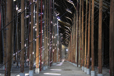 Victorian Interpretive Projects Inc.
Photograph - digital, LJ Gervasoni, Murtoa Stick Shed 00031, 13/08/2011
... set in a concrete slab floor and braced with iron tie rods... set in a concrete slab floor and braced with iron tie rods ...From the Victorian Heritage Register statement of significance H0791 The Marmalake/Murtoa Grain Store, originally the No.1 Murtoa Shed, is located within the Murtoa Grain Terminal, adjacent to the grain elevator tower and railway line. The shed is 280m long, 60m wide and 19m high at the ridge with a capacity of 3.4 million bushels. The hipped corrugated iron roof of the shed is supported on approximately 600 unmilled hardwood poles set in a concrete slab floor and braced with iron tie rods. These poles are the reason for use of the term "stick shed". With its vast gabled interior and the long rows of poles the space has been likened to the nave of a cathedral. An elevator at one end took wheat from railway trucks to ridge level where it was distributed by conveyor along the length of the shed, creating a huge single mound of grain. Braced internal timber bulkheads on either side took the lateral thrust of the wheat, and conveyors at ground level outside the bulkheads took wheat back to the elevator for transport elsewhere. Wheat had been handled in jute bags from the start of the Victorian wheat industry in the mid nineteenth century. Bulk storage had been developed in North America from the early 1900s. NSW began building substantial concrete silos from 1920-21. In Western Australia, farmers' co-operatives, who had to supply their own bulk storage from 1934-5, pioneered the use of low-cost horizontal sheds of timber and corrugated iron for bulk storage. Following its establishment in 1935 the Victorian Grain Elevators Board (GEB) planned a network of 160 concrete silos in country locations, connected by rail to the shipping terminal at Geelong. By the outbreak of the Second World War there was a worldwide glut of wheat, and Australia soon had a massive surplus which it was unable to export. Only 48 silos had been established under the Victorian Silo Scheme so far, and wartime material and labour restrictions prevented progress with this scheme. The storage deficit had become an emergency by 1941 as Britain obtained its imports from North America, rather than over the lengthy and difficult shipping route from Australia. In 1941 the GEB, under chairman and general manager Harold Glowrey, proposed large temporary versions of the horizontal bulk storage sheds already in use in Western Australia. The proposal was approved by the Victorian Wheat and Woolgrowers Association, who considered the use of shed storages as a longer term proposition. After initial resistance from the Australian Wheat Board, some of whose members represented wheat bagging interests, the Commonwealth and Victorian governments agreed to split the costs, and Murtoa was chosen as a suitable site for the first emergency storage. The main contractor, Green Bros, commenced work on the No.1 Murtoa Shed in September 1941, deliveries of bulk wheat began in January 1942, and the store was full by June of the same year. In the following years the Council for Scientific and Industrial Research (later CSIRO) conducted valuable research and experiment on the impacts and control of insect pests at the Murtoa No.1 shed. With these discoveries, and the development of more effective pesticides, use of the No.1 shed and the larger No.2 shed, erected in 1942/43, continued for many years. The No.2 shed was demolished in 1975. By the 1990s, pest resistance to pesticides and requirements for both pest free and insecticide free grain rendered open storage of this type unviable. The No. 1 store was also becoming increasingly expensive to maintain, and its use was phased out from 1989.Image of the Marmalake/Murtoa Grain Store which is of historical, architectural, scientific (technical) and social significance to the State of VictoriaDigital colour image of the interior of the Marmaduke . Murtoa grain storage facility better known as the Stick Shed. The shed was constructed in World War Two to store grain. The supporting columns are trees.marmalake, murtoa grain store, wheat store, stick shed, murtoa -
 Wodonga & District Historical Society Inc
Photograph - Bethanga Bridge
... with a concrete waffle slab deck 7.7metres wide. In 1961 the bridge deck... with a concrete waffle slab deck 7.7metres wide. In 1961 the bridge deck ...The Bethanga Bridge was built between 1927 and 1930 as a joint venture between Victoria and New South Wales and was a key element of the River Murray Waters Agreement. It consists of nine spans of 82 metres long. Each span is supported between double reinforced concrete pylons and a riveted steel camel back Pratt truss. The overall span of the bridge is a length of 752 metres. It was completed in 1929 at a cost of £194,000. The road deck was initially constructed from timber but was replaced in 1961 with a concrete waffle slab deck 7.7metres wide. In 1961 the bridge deck and truss structure were raised 300 millimetres to allow for the enlargement of the lake. The bridge was designed in NSW by road engineer Percy Alan and the trusses were built by the Charles Ruwolt Pty. Ltd. Charles Ruwolt Pty. Ltd. was originally established by Charles Ruwolt as a foundry at Wangaratta in 1902 and transferred its operations to Richmond, Melbourne in 1914. By 1938 it had become one of the biggest engineering companies in Australia. After Charles Ruwolt’s death in 1946, Vickers Ltd. acquired the company and in 1948 the firm became known as Vickers Ruwolt Pty. Ltd. Because of the Bethanga Bridge’s unique location, over the waters of a dam with the border running down the centre of the body of water, the Bethanga Bridge is the only built structure shared by both Victoria and New South Wales. As the border of New South Wales aligns with the southern bank of the Murray River all of the other bridges along its length are deemed to be in New South Wales. The Bethanga Bridge is listed on both the New South Wales State Heritage Register and the Victorian Heritage Database. In 2015 the Bethanga Bridge was nominated for a heritage award by the Institution of Engineering Australia.These images are significant because they document the construction of a bridge which links Victoria and New South Wales and has been recognised for its historical, technical and engineering significance.A collection of photos documenting the construction of the Bethanga Bridge which links the States of Victoria and New South Wales as part of the construction of the Hume Dam .bethanga bridge, hume dam constuction, charles ruwolt, percy allan engineer -
 Eltham District Historical Society Inc
Photograph - Digital Photograph, Alan King, Downing-Le Gallienne house, Yarra Braes Road, Eltham, 30 January 2008
... with a pitched slate roof. It was built on a concrete slab and included... with a pitched slate roof. It was built on a concrete slab and included ...The property is a classic example of what made Eltham famous from the late 1940s to the 1960s. Covered under Heritage Overlay, Nillumbik Planning Scheme. Published: Nillumbik Now and Then / Marguerite Marshall 2008; photographs Alan King with Marguerite Marshall.; p149 The first view of the large double-storey house at Yarra Braes Road, Eltham South, is of a jutting roofline over a balcony, reminiscent of a large sailing vessel or galleon – very appropriate, considering the name of one of the first owners, Le Gallienne. The Downing-Le Gallienne property is a classic example of what made Eltham famous from the late 1940s to the 1960s and attracted so many artists and intellectuals to the area. Set in a largely indigenous bush-style garden, the mud-brick and timber house was built by Alistair Knox. It was built for economist Richard Downing, to become a founder of the welfare state in Australia and Chairman of the Australian Broadcasting Commission, and musician and composer Dorian Le Gallienne. Le Gallienne was a pioneering composer of modern music in Victoria before 1945, whose works included the Symphony in E.1 He wrote several pieces of film music for Eltham Films, including The Prize, working with its writer and artistic director Tim Burstall. Le Gallienne was also a music critic for The Argus and later for The Age. In 1967 the music critic Roger Covell argued that Le Gallienne’s Symphony, was ‘still the most accomplished and purposive . . . written by an Australian’. According to Alan Marshall the main inspiration behind the building that evolved from 1948 to 1964 was Le Gallienne. ‘He was able to see value in the simplest things and many who worked there had their eyes opened for the first time to the Eltham environment, to the bush and the trees and the fauna which lived there.’ The garden included no formality, no lawns, nor exotic plants. ‘Natural informal growth came right up to their doors and so did the indigenous birdlife.’ This informal style – consisting of mass and void – was to be developed and popularised by landscaper Gordon Ford from the 1950s. The large mud-brick and timber house, which was built in four stages and has three separate but linked sections, began as a small weekend retreat for the couple. In 1948, Downing and Le Gallienne (Dick and Dor to their friends), asked Knox to build the 36 x18 foot (11mx5.4m) building with a pitched slate roof. It was built on a concrete slab and included a fireplace, which is still in use. The second wing was built in 1954 after Downing had returned from working at the International Labour Office and the couple decided to live there full-time. The third section was built after the death of Le Gallienne in 1963, aged 48. He is buried in the Eltham Cemetery. When Downing married widow, Jean Norman (nee McGregor) and had to accommodate a large family, including her six children and one of their own, the last stage was built by 1964. At that time the house was considered one of the largest mud-brick houses in Victoria. It consists of five living areas, including a small ballroom. Several artists helped Knox build the Downing-Le Gallienne house, which was one of his first of mud-brick. They included painter Clifton Pugh, artist John Howley and actor Wynn Roberts. Ellis Stones had landscaped the first wing and Gordon Ford set the boulder steps and made a pool as part of the landscaping he completed. Inside, the mud-bricks are largely whitewashed with pine-lined ceilings and Oregon beams. A winding timber staircase in the front extends behind a glass window from the ground floor to the top. The property, of a little more than 0.5 ha, is bordered by Parks Victoria land, which extends to the Yarra River.This collection of almost 130 photos about places and people within the Shire of Nillumbik, an urban and rural municipality in Melbourne's north, contributes to an understanding of the history of the Shire. Published in 2008 immediately prior to the Black Saturday bushfires of February 7, 2009, it documents sites that were impacted, and in some cases destroyed by the fires. It includes photographs taken especially for the publication, creating a unique time capsule representing the Shire in the early 21st century. It remains the most recent comprehenesive publication devoted to the Shire's history connecting local residents to the past. nillumbik now and then (marshall-king) collection, dorian le gallienne, downing-le gallienne house, eltham, mudbrick construction, mudbrick houses, richard downing, yarra braes road -
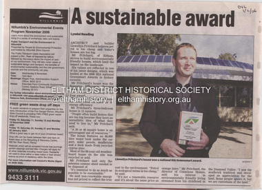 Eltham District Historical Society Inc
Document - Property Binder, 1184 Main Road, Eltham
... degrees, assisted by the concrete slab floor. The many large... degrees, assisted by the concrete slab floor. The many large ...Newspaper article: A sustainable award, Diamond Valley Leader, 1 November2006, Architect and building Llewellyn Pritchard won resource Efficiency Housing Award, finalist in HIA Greensmart Building of the Year Award. House – Environmental Leader (Published: Nillumbik Now and Then / Marguerite Marshall 2008; photographs Alan King with Marguerite Marshall.; p186) In 2006 environmental awareness was mushrooming in the community, which is reflected in the award-winning house at Main Road near Wattletree Road, Eltham. At first sight, the building appears a mix of a classic Eltham mud-brick house and an avant-garde building style. The crown of solar panels stretching along the width of the curved roof, indicates that this is no ordinary house. In fact it signals a new building trend of minimal impact on the environment. Yet it utilises the environment with high technical expertise to achieve comfort and cut running and maintenance costs. In recognition of this, its designer/builder, Conscious Homes, won the 2006 National HIA Greensmart Resource Efficiency Award. For Conscious Homes director, Llewellyn Pritchard, this house reflects a philosophy, strengthened by his connection with Aboriginal culture, through his foster siblings. Pritchard believes the sustainable way indigenous Australians lived and their spiritual connection with land, demonstrates how humanity is part of the ecology. His interest in environmental design stemmed from growing up in bushy Eltham Shire, with its mud-brick tradition. This was followed by studying Architecture at RMIT in the early 1980s, and learning about passive solar design. Pritchard says this house demonstrates that environmental sustainability is not about sacrifice, but about exceptional levels of occupant comfort, savings in running costs and modern fittings and appliances.1 The solar panels on the north roofs are intentionally obvious to make a statement about what the building is doing. But inside the systems are hidden and interactive with conventional services, such as the underground water tank. The house is water and energy self-sufficient and at 12 squares is much smaller than conventional houses, to minimise resources. Yet it accommodates his family of four with three bedrooms, a living/dining and kitchen area and a bathroom/laundry. Importantly the building is designed to last hundreds of years, by being able to be modified as the need arises, such as for commercial use. In this way the structure minimises its environmental impact. The solid double mud-brick walls (which are insulated) include steel beams and supporting frame, allowing the future removal or alteration of any section. The materials are local, recycled and of low toxicity where possible.2 Inside and out, the mud-brick is rendered and sealed with a combination of cement and sand and a mud-based coating in a soft golden hue increases its life. Inside, the golden-brown timber is plantation Mountain Ash and the concrete floors throughout – of local stone aggregate with a clear seal – have a natural looking random stone appearance. The house sustains a stable temperature of around 20 degrees, assisted by the concrete slab floor. The many large double-glazed windows and highlights (windows set high on walls) provide cross-flow ventilation. The north-facing living area maximises heating from the lower winter sun and is cooler in summer, because the sun is higher. Heating comes from a solar hydronic slab system. All appliances and fittings are high efficiency energy or water rated. Appliances in the timber kitchen include a gas stove and a dishwasher, using the building’s own power and water. French doors open from the living area to a deck, concealing the treatment system for all waste water. This is pumped through sub-soil drippers to the indigenous garden beds and no-dig vegetable patch. Below the carport is the 80,000-litre rainwater tank and at the back, the boiler room houses the solar boiler, water tank access, domestic water supply pump, filter gear and hydronic slab heating controls. The solar system is backed up with gas, which is needed to heat water only in winter. Gas used is less than one quarter of that for an average home with ducted heating. Excess power is fed back to the grid and the building uses about one quarter of the mains electricity of an average home. Other local builders have followed Pritchard’s lead in resource efficiency for minimal environmental impact.main road, eltham, businesses, llewellyn pritchard, hia greensmart building of the year award., efficiency housing award, conscious homes australia pty ltd -
 Federation University Art Collection
Painting - Mural, French, Leonard, 'The Tapestry' by Leonard French, 1959
... for his enormous dalle de verre (concrete and slab glass) ceiling... Heathcote, Victoria Known for his enormous dalle de verre (concrete ...Artist Leonard French said of this work:- "The centre panel suggests a tree of knowledge growing out of a jewelled fish (a spiritual accompaniment is intended), and from the tree birds rise, spreading out through the cloud shapes of the other panels. Hands and figures rise from the earth, reaching for the birds. The left hand panel depicts the journey of figures in a boat, the seeking after or journeying to the source of knowledge. The far right hand panel is the garden, figures in a primitive state, a sort of evolution of figures from a primitive garden (the first garden). Visualization, verbalization, music and dance are tools we have to express a concept. The analysis of an art work is a delicate and sensitive task and great harm can be done in an attempt to become verbal about a form which relies upon elements peculiar to itself for intrinsic meaning." Leonard FRENCH (OBE) (08 October 1928 - 10 January 2017) Born Brunswick, Victoria Died Heathcote, Victoria Known for his enormous dalle de verre (concrete and slab glass) ceiling in the Great Hall of the National Gallery of Victoria Leonard French produced a large body of work throughout his lifetime. French won the Sulman Prize in 1960, and the Blake Prize for Religious Art in 1963 and in 1980. He was also awarded a Harkness Fellowship in 1965. In the Queen's Birthday Honours of June 1968 he was appointed an Officer of the Order of the British Empire. In early 1959 Leonard French was commissioned by the Ballarat Teachers' College students to paint a mural. The students were responsible for the payment of the work. When unveiled artist George Bush remarked: "the 1959 students have left something not just to 'oooh' and 'ah' at, but something that is thought provoking, arresting and interesting. This work of art keeps something in reserve and draws you to search for deeper meaning behind the splendour of colour. This mural is not one which will not fade the interest of its beholders, but one which will provide intrigue for generations to come." Originally French intended the mural to be five panels, each entitled (left to right) 'the Journey', 'Man', 'The Tree', 'The Earth', 'The Garden'. The finished mural was reduced to four panels with the central tree incorporated into the panels 'Earth' and 'Man'. Ballarat Teachers' College Art lecturer Arch Cuthbertson explained that the artist:- "Aims at evoking emotional flashed, opening doors to simultaneous thinking and feeling. To accomplish this he juxtaposes the threads of conscious and unconscious images, thus effecting a tapestry that allows many points of reference to converge upon his singular images. Whether the colours offer metaphysical sensations or convey a literal meaning will depend upon the breadth and depth of the viewer's experience. Similarly with the bird - we might well ask is it a defiance of gravity, a metaphysical ascension or the elusive winged knowledge? Again the answer could well be that these three associations have a singular purpose. " This item is part of the Federation University Art Collection. The Art Collection features over 2000 works and was listed as a 'Ballarat Treasure' in 2007.A four panel mural by Leonard French, commissioned and gifted by the Ballarat Teachers' College Student in 1959. Art lecturer Arch Cuthbertson was highly involved in this commission. Artist Charles Bush unveiled the mural at the Ballarat Teachers' College in Gillies Street, Ballarat. At that time he said:- "You have left behind you on object which will be full of interest to a lot of people. A work of art, so long as it is in existence, is constantly under review. Most of the good things that keep on going are usually to the uninitiated a little worrying. Many of you will be worried by this, because it does not make its message immediately clear. But come back and assess it again and again." art, leonard french, french, artwork, mural, ballarat teachers' college, class of 1959 -
 Ballarat Tramway Museum
Photograph - Colour Photograph/s - set of 18, Carolyn Dean, 6/05/2000 12:00:00 AM
... concrete 17. New slab over old 18. and extending front step.... delivering concrete 17. New slab over old 18. and extending front ...Set of 18 photographs of the completion of the sheds and commencing on the house extensions at Bungaree over the period 6/5/00 to 24/6/00. All taken by Carolyn Dean. 6/5/00 1. Cladding the second shed 2. ditto 3. ditto 4. House being repainted and wheels storage 7/5/00 5. Fittings doors to first shed - trail fit 6. House block 7. Roof sheeting to 2nd shed 8. The two sheds 11/6/00 9. The two sheds complete with doors and flashings 10. House with sheds in background (photo used in July 2000 Fares Please! and 1999-2000 Annual Report) 11. ditto 12. House extensions - old shed demolished 13. Modifying pipe work 14. ditto 15. Old foundations 16. Mini mix delivering concrete 17. New slab over old 18. and extending front step.All have date and "Photo by Carolyn Dean" on rear.bungaree, sheds, house extensions