Showing 382 items matching "dandenong creek"
-
 Ringwood and District Historical Society
Map - Public Land Sale by Thomas Ham, 2000 Acres for Sale - Crown Sections 20, 23, 24 - Ringwood, Victoria - 1855
... . Inset map enlarging area between Yarra River and Dandenong Creek.... Inset map enlarging area between Yarra River and Dandenong Creek ...Two 1850s surveyor's maps on cardboard backing showing area from Melbourne extending East beyond Bulleen and Nunawading. Detailed description of lots for sale and navigational directions to the property from Richmond by Thomas Ham, Victorian public servant, map maker, publisher, lithographer and original Ringwood land owner. Inset map enlarging area between Yarra River and Dandenong Creek, with southern boundary of allotments later forming part of Oban Road, North Ringwood.TRANSCRIPT: "This really valuable Property is now offered to the public for sale, in lots to suit purchasers at the Iow rate of £1 per Acre for 80 acres and upwards, and £1.10s per Acre for any smaller portion. Terms of payment Half Cash, Balance in 6 and 12 months, bearing 8 per cent interest. The Estate is well wooded with Gum, Cherry Tree and Stringy Bark, with Wattle in the valleys of the several creeks. Every lot is Staked and Trenched at the corners marked on the Plan thus - The Surveyor has carefully sub-divided the Property, in order to give every Farm a Creek for Water, Valley for Cultivation, and Hills for House and Grass Paddock. The ROADS have been very carefully laid out so as to give a firm, well drained, and nearly level road to each Homestead. Intending purchasers can readily find the property by the following directions, viz: Start from Richmond Bridge, at Hawthorne, then take the left-hand road to KEW. When at the "Woodman Inn", take the Cotham Road to the right, bearing due east, keep this Road, passing Trainor's "White Horse" Inn, and before you leave the fences, you will see calico bills (see margin) nailed to the Trees on the bush track leading to the Upper Yarra country, follow the Bills till you come to the SOUTH boundary line of the Property, which bears East and West (see Plan) where you will see Bills nailed up "THIS PROPERTY FOR SALE, etc." The Bills from Town lead direct to where Mr. Jull is erecting his Store, and arrangements have been made with him to show the lots to intending purchasers free of charge. At the respective corners of the lots the Bills are nailed up double, with numbers to denote the lot, and that the corner stake is adjacent. Any parties wishing to proceed to the property by way of BULLEEN will find Bills nailed on the Trees, commencing at the NEW INN, at "Wilson's Slip Rail." Keep this Track till you come to the Log Bridge, over the Deep Creek at Bloxhome's Paddock; go through the land now being cleared; keep the track over the hill till you come to an Iron House, you will then be on the property, which Iies to the North and East as per Plan. Follow the Bills till you come to Mr. Jull's Store, etc. etc. Further particulars can be had from the Agent for the Property. THOMAS HAM. " -
 Ringwood and District Historical Society
Map, Plan of Country Lands in the Parishes of Nunawading Ringwood and Scoresby - circa 1855
... wooded. It is watered by Dandenong Creek and Deep Creek." Inset..., moderately undulating, and thickly wooded. It is watered by Dandenong ...Blueprint copy of Survey Map detailing original Selectors' names and property locations. List of Parish map references including property bearings, distances in Links, and markings on trees. Descriptive remarks include areas marked "Farmer's Common", "Poor soil thickly/moderately timbered with stringy bark", and location of water and firewood reserves."Surveyed and plotted by N.M. Bickford, Superintendant of Mr. Hodgkinson's Field Party". "The land comprised in this survey is of inferior quality, moderately undulating, and thickly wooded. It is watered by Dandenong Creek and Deep Creek." Inset map showing location of (*proposed) cemetery on southern corner of Lillydale Road from Melbourne and Sawmill Road, later Mount Dandenong Road. (*Cemetery did not eventuate.) -
 Ringwood and District Historical Society
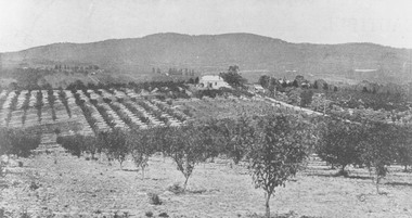
Photograph, View from Canterbury Road/Balfour Avenue area overlooking Martell's orchard, Heathmont, 1929
... . Dandenong Creek just beyond house. Washusen Rd. on right". Written.... and Balfour Ave. looking south. Dandenong Creek just beyond house ...Black and white photograph of orchard. House in middle range, mountains in background. Photograph appears to be reproduced from subdivisional brochure. Note inserted in sleeve reads, "It has been pointed out that the mountains are to the east and the view is looking south. This therefore is not a 'straight' photograph. House still exists in Eden Avenue at October, 1996".(3 copies).Typed below photograph, "Panoramic view taken on the estate". "View overlooking Martell's orchard, Heathmont, 1929". Taken from corner Canterbury Rd. and Balfour Ave. looking south. Dandenong Creek just beyond house. Washusen Rd. on right". Written on back of one of the copies, "Heathmont Station Estate 1922". "Station Street, Lisgoold St. Canterbury Rd. Vivienne Cres. Balfour Ave." -
 Whitehorse Historical Society Inc.
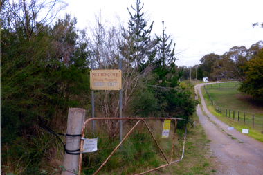
Photograph, Nethercote property, 2012
... was situated in Boronia Road near Dandenong Creek. Originally a flower... which was situated in Boronia Road near Dandenong Creek ...The land photographed is widely known as Nethercotes. In 1920 Arthur Nethercote, import agent, bought the land which was situated in Boronia Road near Dandenong Creek. Originally a flower farm, the Nethercotes became poultry farmers. The property contained a five-roomed weatherboard house which they called Weston Favell. Dated before 1883 (from newspapers found in the ceiling) it is the more dilapidated house photographed. The other house called Greenways was built for a son. Gerald Letts bought the property and when he died the Board of Works purchased the land, intending to use it as part of the proposed Healesville Freeway, meanwhile the property was leased to the Box Hill Institute's equine department. In 2013 the Board of Works announced that the freeway would not go ahead.Coloured photographs of the two houses and land at the Nethercote property, Vermont. Now owned by the board of Works and leased to the Box Hill Institute.nethercote property, vermont, board of works, proposed healesville freeway, box hill institute -
 Orbost & District Historical Society
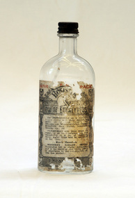
bottle, Probably WW11
... operations in a small, rudely constructed still at Dandenong Creek... operations in a small, rudely constructed still at Dandenong Creek ...Joseph Bosisto was a Yorkshireman who had qualified as a Pharmacist in Leeds and London. He arrived in Adelaide in 1848 at the age of 21. In 1851 he moved to Victoria in search of gold, but instead opened a pharmacy in Richmond, where he built a laboratory to investigate the chemical and medicinal properties of Australian plants. As a result of the collaboration with von Meuller the essential oil industry of Australia began in 1852, when Bosisto commenced operations in a small, rudely constructed still at Dandenong Creek, Victoria, using the leaves of a form of E. radiata (then known as E. amygdalina) which grew profusely in the district. Bosisto soon built other distilleries at Emerald, Menzies Creek and Macclesfield. World War II soldiers packed it in their mess kits to keep foot fungus in the tropics at bay. Small clear glass Eucalyptus Oil bottle with metal screw lid and large label on front.Front Label - War Time Pack Back - This bottle remains property of J Bosisto &Co Pty Ltd Richmond Victoria Bottom-F1196bottle eucalyptus-oil bosisto-joseph -
 Ringwood and District Historical Society
Document, List of bushland reserves in Maroondah - early 2000
... is next to Dexter's, on the Dandenong Creek. Good luck, Helen Moss.... the Alexander's land, which is next to Dexter's, on the Dandenong Creek ...Typed document"Attached to List" Hand written note from Helen Moss to Gayle Abbe ( Archivist Ringwood Historical Society) "Here is some information on Dexters Bush and a report I prepared on the bushland reserves in Maroondah which mentions many of the relevant Ringwood reserves. There is also a copy of my phone list for reserves contacts. Roger Lord is listed - so is Anne Kaufman who knows the Angus Avenue/Ruthven Way area very well and may be able to suggest some additions to your heritage list. It would also be worth talking to Eva about the Alexander's land, which is next to Dexter's, on the Dandenong Creek. Good luck, Helen Moss. -
 Ringwood and District Historical Society
Pamphlet, G.A. Green, Auction Sale Brochure - Garden Farms Estate, Ringwood, Victoria - 1919, 1919
... Dandenong Creek, to its southern boundary on the main Bayswater Road... of New Bridge over Dandenong Creek. (Image) On one ...Multi-fold brochure advertising public auction of one-acre, 2-acre, 5-acre and 8-acre allotments in Ringwood and Bayswater on Saturday 12th April, 1919. Brochure includes terms of sale, description of subdivision features and local facilities, and photographic images of the area.Subdivison includes Canterbury Road Heathmont, Armstrong Road Heathmont, Armstrong Road Bayswater, Bungalook Road Heathmont, Bungalook Road Bayswater, and Orchard Road Bayswater. Road shown as Bayswater Road to Bayswater became Mountain Highway Bayswater. Vendor: H.E.B.Armstrong, Auctioneers: Coghill & Haughton, 79 Swanston Street Melbourne, Telephone Central 2793, in conjunction with J.B. McAlpin, Ringwood, Opposite Station, Telephone Ringwood 7. (Map) Woodcock & McCormack, Civil Engineers Architects & Surveyors, 430 Little Collins Street, Melbourne, Phone 3241 Central. MOST OF THE MONEY COMES OUT OF THE LAND. And more money can be obtained from anb acre of fruit than from an acre of any other produce. But you do not have to grow fruit on Garden Farms Estate. You can go in for - Outer Suburban Home - Market Garden - Orchard - Pig Raising - Poultry Farm - Small Dairy Farm - Small Fruits - Floral Culture - Scent and Bee Farm - Or just for a Week-end Home. RINGWOOD - THE PLACE TO LIVE. The Beautiful Ringwood District has so many natural attractions, that half a Land Agent's work is done in just showing a prospective buyer round and about. Ringwood has a pull of its own that attracts folk, proved beyond doubt by its rapid development within the last decade (spite the war). First, it is high and healthy, picturesque and undulating, convenient of access, sufficiently close to the Metropolis for City and Business folk to live at Ringwood. Its development is solid, because most of its people are industrious husbandmen, real producers, who have turned idle hills into smiling gardens. These are the kind of real people to live amongst; ones who wear out their spades. The rapidly-developing town has excellent Stores, Trade and Repair Shops Churches, Banks, Telephone Exchange, Weekly General Market, Cool Stores, and good Private and State Schools, etc.; is Electrically lit, has Metropolitan Water Supply, and generally provides so that practically all shopping can be done locally. WHY RINGWOOD MUST GROW. Ringwood is a great centre and must be a greater. Two rapidly-developing railways junction here. The passengers from Ringwood Station cityward, in one year, number 250,000. Ringwood will be the terminus of the Outer Suburban Electric Eastern Railway. Its natural boundaries are the River Yarra on the North, Dandenong Creek on the South, the popular town of Croydon on the East, and the suburb of Mitcham on the West. This is a large territory that is steadily being converted from intense culture, and then it might be called (as regards its gardens) "The Devon Territory of Victoria." ARMSTRONG ROAD. This new road traverses Garden Farms Estate from its northern boundary on the main Canterbury Road, across Dandenong Creek, to its southern boundary on the main Bayswater Road, and will provide a long-desired additional link of communication between Bayswater and Ringwood. The 1-acre building sites on Bayswater Road are within 8 minutes' walk of the Bayswater Railway Station, and the Canterbury Road frontages are only 1-1/2 miles from Ringwood Station, and 1/2 mile from the Railway Station site of Canterbury Road; therefore, the whole Estate is easy of access and there should be a large demand for land so favourably placed. (Image) Cultivation Field - Potatoes on Lot 28 (Image) Picture of Bayswater Creek Flats. (Image) View from "Korumbeen" where Mr. Armstrong lived on Garden Farms Estate. Estate outlined in white ring. (Image) Site of New Bridge over Dandenong Creek. (Image) On one of the timbered lots adjoining railway. (Image) This Dandenong Creek traveres the Estate. (Image) Main Fern Tree Gully Line bisects the Estate. -
 Ringwood and District Historical Society
Pamphlet, Land Sale Brochure Titled Eureka Plan Book - Seven Delightful & Valuable Ringwood Estates - circa 1925
... of Creek Estate, Ringwood, includes Dandenong Creek, Wantirna Road..., includes Dandenong Creek, Wantirna Road and Gordon Crescent. Plan ...Twenty page land sale brochure including photographs, subdivision features and local facilities. Additional flyer with conditions of sale and prices for estate blocks.Seven delightful and valuable Ringwood Estates called Bestpart, Paradise, Hill Top, Greenwood, Creek, Station, and School Estates. These nestle amidst the hills and valleys of beautiful Ringwood district. Also Goodluck Estate at Clarinda. Pamphlet marked as being From Mr. Farmer, No. 5 Flinders Court, Melbourne. Phone 988, 989 Central, or 55 Ringwood after 7 p.m. Plan of Ringwood School Estate includes William Street (later Kendall Street), Greenwood Avenue, Alton Street and Locke Street. Plan of Bestpart Estate, Ringwood, includes Bedford Road, Wilana Street, Greenwood Avenue, Caroline Street, Henry Street and Haig Street. Plan of Ringwood Station Estate includes Pitt Street, Bedford Road, Greenwood Avenue, Station Street, William Street (later Kendall Street, James Street, Wantirna Road, Caroline Street, Henry Street, Ellison Street and Haig Street. Plan of Geenwood Estate, Ringwood, includes Prussian Road (later Geenwood Avenue). Plan of Paradise Estate, Ringwood, includes Canterbury Road, Dandenong Road (Wantirna Road), Luck Street and Paradise Road. Plan of Creek Estate, Ringwood, includes Dandenong Creek, Wantirna Road and Gordon Crescent. Plan of Hill Top Estate, Ringwood (later Heathmont area), includes Heathmont Railway Station, Heathmont Road, Balfour Avenue, Lilian Street, Edith Street, Edna Street and Great Ryrie Street. Plan of Goodluck Estate, Clarinda, includes Talbot Avenue, Good Street, Luck Street, and Centre Road in locality plan between Oakleigh and Clayton Railway Stations. -
 Upper Yarra Museum
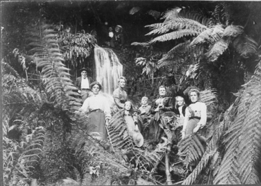
Negative Photographic Reproduction, Jenkins family at Millgrove, 1893, 14.2.1988 (exact)
A very popular pastime was to have outings in the bush, with friends or family.Jenkins family at Millgrove, 1893. Negative Black white. Scanned at 600 dpi. This is set amongst Tree Ferns with a small waterfall left of centre, there are 2 men to the right at the top of the falls both with mustache's one with a hat,Below to the Left is Mr Jenkins Senior with a full beard & hands on his hips, in front is a young lady, on the right is another slightly older lady with 2 children a girl in front and boy to her right,and then Mrs Jenkins with a little girl next To her, and her mother to the right.ferns, millgrove, falls, jenkin family creek waterfall -
 Upper Yarra Museum
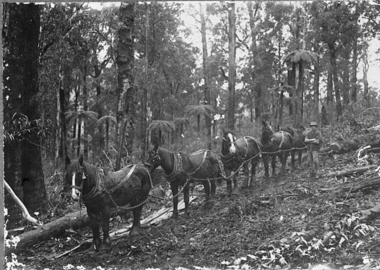
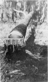
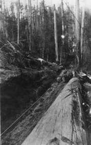
Negative Photographic Reproduction, Horse team at work, Hoddles Creek, 13/4/1983
This was the one way of transporting logs to the Timber MillNegative Black white Scanned at 600 dpi. Horse team at work, Hoddles Creek, A four Horses Team "Snigging" a log out of the bush, one man in charge of the team.timber, horse team, sandy ross, hoddles creek, snigging -
 Upper Yarra Museum
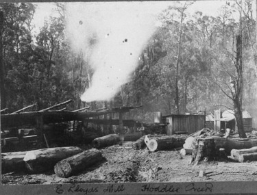
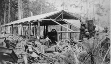
Negative Photographic Reproduction, E Lloyds Mill, Hoddles Creek, 13/4/1983
This looks like a typical Bush Timber Mill of the period, E Lloyd's Mill, Hoddles Creek Negative Black white. Scanned at 600 dpi. There are five men at work at the mill and also a lady sitting on the front verandah of the nearest hut, possibly mending some material , there are 2 other. hutse lloyds mill timber workers women hoddles creek logs sandy ross -
 Upper Yarra Museum
Negative Photographic Reproduction, Arthur Witnish's horse team hauling timber across bridge over Black Sands Creek, 14.2.1983
Black and white negative of Arthur Witnish's horse team hauling timber across bridge on Black Sands Road. Negative Black white. Scanned at 600 dpibridge, timber, arthur witnish, horse team, tramway, black sands creek, timber truck, gladysdale -
 Upper Yarra Museum
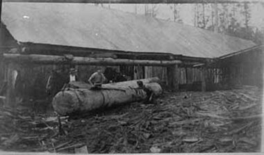
Negative Photographic Reproduction, Workmen at E. Lloyds mill, Hoddles Creek, 14.2.1983
Workmen at E. Lloyd's mill, Hoddles Creek Negative Black white. Scanned at 600 dpi. mill, timber, lloyds, workmen -
 Upper Yarra Museum
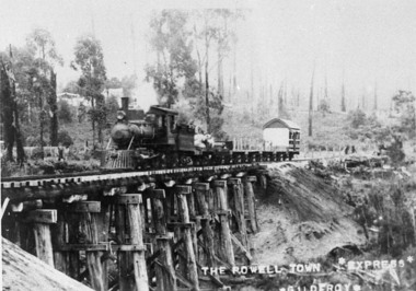
Negative Photographic Reproduction, Powelltown Express 1914 Gilderoy, 14.2.1983
The "Express" is pulled by the Little Yarra steam train, and is on a wooden trestle bridge crossing the Saxton creek at Gilderoy, the carriage on the end was for passengers, but it was only used for a short timePowelltown Express 1914 Gilderoy. Negative Black white Scanned at 600 dpi. trestle bridge tramway powelltown steam engine saxton creek gilderoy a ross -
 Upper Yarra Museum
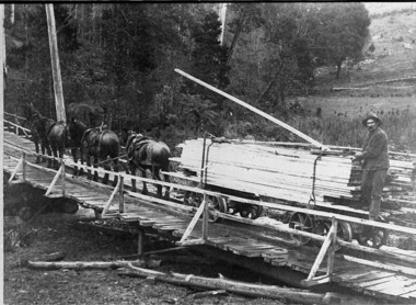
Negative Photographic Reproduction, Laying the tram track to Clover Dell Mill with E. Smith , W Towers …. Hoddles Creek
Laying the tram track to Clover Dell Mill with E. Smith , W Towers & ? Hoddles Creek Negative Black white Scanned at 600 dpi.laying tram track clover dell mill e smith w towers hoddle creek -
 Upper Yarra Museum
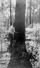
Negative Photographic Reproduction, H. Lepoidevin preparing a tree for falling Early 1920s Hoddles Creek, 2.10.1983
H. Lepoidevin preparing a tree for falling Early 1920s Hoddles Creek Negative Black white Scanned at 600 dpi.h lepoidevin prepare tree falling hoddles creek early 1920s -
 Upper Yarra Museum
Negative Photographic Reproduction, H. Lepoidevin falling a tree Early 1920s Hoddles Creek
H. Lepoidevin falling a tree Early 1920s Hoddles Creek Negative Black white Scanned at 600 dpi.h lepoidevin falling tree hoddles creek early 1920s -
 Upper Yarra Museum
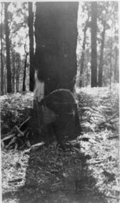
Negative Photographic Reproduction, The fallen tree Early 1920s Hoddles Creek
The fallen tree Early 1920s Hoddles Creek Negative Black white Scanned at 600 dpi.fallen tree hoddles creek early 1920s -
 Upper Yarra Museum
Negative Photographic Reproduction, Mc Crae Creek Mill Beenak, 2.10.1983
... Highway Yarra Junction yarra-valley-and-dandenong-ranges mc crae ...Mc Crae Creek Mill Beenak Negative Black white Scanned at 600 dpi.mc crae creek mill beenak -
 Upper Yarra Museum
Negative Photographic Reproduction, Working on a log at a mill Hoddles Creek
Working on a log at a mill Hoddles Creek Negative Black white Scanned at 600 dpi.working log mill hoddles creek -
 Upper Yarra Museum
Negative Photographic Reproduction, Working with horses at Mc Crae Creek mill 1945 Beenak
Working with horses at Mc Crae Creek mill 1945 Beenak Black and White negative scanned at 600 dpiworking horses mc crae creek mill beenak 1945 -
 Upper Yarra Museum
Negative Photographic Reproduction, Bulldozer working at Mc Crae Creek mill 1945
Bulldozer working at Mc Crae Creek mill 1945 Black and White negative scanned at 600 dpibuldozer working mc crae creek mill 1945 -
 Upper Yarra Museum
Negative Photographic Reproduction, Workers winching a log at Pioneer Creek
Workers winching a log at Pioneer Creek Black and White negative scanned at 600 dpiworkers winching log pioneer creek -
 Upper Yarra Museum
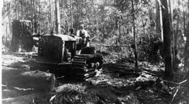
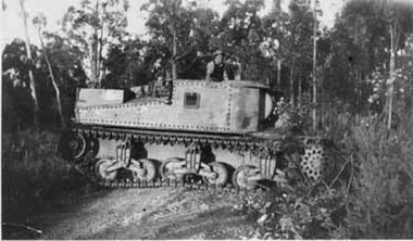
Negative Photographic Reproduction, George (Mick) Worlley’s Grant tank used for clearing scrub 1952 Hoddles Creek
George Worlley bought a Grant Tank from Bandiana for clearing scrub and falling trees for the mill in 1952George (Mick) Worlley’s Grant tank used for clearing scrub 1952 Hoddles Creek Black and White negative scanned at 600 dpi Check no -
 Eltham District Historical Society Inc
Book, Land Conservation Council, Report on the Melbourne Study Area, December 1973
... , Kinglake, Donna Buang, Upper Yarra, Thomson, Dandenongs, Bunyip ...This report is one of a series describings the physical nature of the land and its environment, examines the likely forms of land use, and assesses the hazards associated with these uses. It is divided into four main sections: Introduction, Characteristics of environment, main forms of land use and description of 24 specific blocks in the study area which include Torquay, Brisbane Ranges, Werribee, Wombat, Loddon, Romsey, Puckapunyal, Strathbogie, Eildon, Disappointment, Break O'Day, Black Range, Cerberean, Upper Goulburn, Kinglake, Donna Buang, Upper Yarra, Thomson, Dandenongs, Bunyip-Latrobe, Shady Creek, Tyers, Westernport and Strzelecki. The Land Conservation Act 1970 established the Land Conservation Council whose functions is to "carry out investigations and make recommendations to the Minister with respect to the use of public land in order to provide for the balanced use of land in Victoria. This report sets out to describe and assess the natural resources of the public lands in the Melbourne area and provides a factual basis on which members of the community may base submissions to the [Land Conservation] Council of Victoria.444 pagesnon-fictionThis report is one of a series describings the physical nature of the land and its environment, examines the likely forms of land use, and assesses the hazards associated with these uses. It is divided into four main sections: Introduction, Characteristics of environment, main forms of land use and description of 24 specific blocks in the study area which include Torquay, Brisbane Ranges, Werribee, Wombat, Loddon, Romsey, Puckapunyal, Strathbogie, Eildon, Disappointment, Break O'Day, Black Range, Cerberean, Upper Goulburn, Kinglake, Donna Buang, Upper Yarra, Thomson, Dandenongs, Bunyip-Latrobe, Shady Creek, Tyers, Westernport and Strzelecki. The Land Conservation Act 1970 established the Land Conservation Council whose functions is to "carry out investigations and make recommendations to the Minister with respect to the use of public land in order to provide for the balanced use of land in Victoria. This report sets out to describe and assess the natural resources of the public lands in the Melbourne area and provides a factual basis on which members of the community may base submissions to the [Land Conservation] Council of Victoria.land use, kinglake, thomson valley, conservation, public lands -
 Eltham District Historical Society Inc
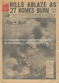
Newspaper - Newspaper articles, Sun News-Pictorial, Hills Ablaze As 27 Homes Burn, The Sun News-Pictorial, Monday, January 15, p1, 1962
Various news articles pertaining to the January 1962 Victorian bushfires in the Dandenong and Healesville districts. • Hills Ablaze As 27 Homes Burn; Night Fight, p1 (Illust.) • Yarra Glen, Healesville Saved; Fire into main street, p2 (Illust.) • Flare-up at Montrose, p2 • 20 scouts flee as fire sweeps camp, p2 • Gaol for fires today …, p2 • Timber lost, p2 • Heathmont home lost, but others saved, p2 • The desperate fight, p3 (Illust.) • Rubbish fire got away; Basin blaze, p3 • Panorama of destruction, p3 • Fire Captain Killed; 7 road deaths at week-end, p5 (Illust.) • Heartbreak, ruin as … Fire Sweeps the Hills, pp18-19 .(Illust.) • Tea; they made it for the fire fighters, pp18-19 (Illust.) tom fielding collection, victorian bushfires - 1962, victorian bushfires – 1962, dandenongs, the basin, yarra glen, healesville, montrose, chum creek, scouts, australian logging co., a.w. larkins, heathmont, vermont, r. pearson, mike ryan, vic parker, c.g. wilson, hillside farm, clive brewer, ron anderson, mrs anderson, mt dandenong, healesville rural fire brigade, malcolm barber, yarra flats, r. bicknell, ferny creek, blue hills gues house, heatherset road, sassafras, olinda, presbyterian manse, john gorie, janice gorie, lynette gorie, jacky wilson, patricia cortie -
 Eltham District Historical Society Inc
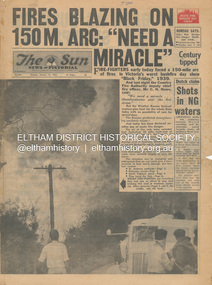
Newspaper - Newspaper articles, Sun News-Pictorial, Fires Blazing on 150M. Arc: "Need a Miracle", The Sun News-Pictorial, Tuesday, January 16, p1, 1962
Various news articles pertaining to the January 1962 Victorian bushfires in the Dandenong and Healesville districts which by second day had spread on to a 150 mile front fromDaylesford and Kinglake through to the Dandenongs. Specific Eltham Shire districts mentioned include Ninka Road, St. Andrews, Kinglake, Hurstbridge on page 2 • Fires Blazing on 150M. Arc: "Need a Miracle", p1 (Illust.) – Victoria’s worst bushfire day since “Black Friday,” 1939 • Night dash as bushfire sweeps by, p2 (Illust.) • Kalorama Saved: Fire 100 Ft. Away, p2 • Stay away, says police chief, p2 • The Tragedy of the Fires, p3 (Illust.) • Good save by firemen, p4 (Illust.) • S.E.C. Firemen Saved N. Yallourn, p4 • Cherry river of flame, p4 • From the fire front: Fire-fighters are bitten by snakes, p4 • They faced the fury, p6 (Illust.) • The ’39 Blaze, p6 • They fought and failed, p6 • Hills Aflame: 2nd Day, pp16-17 (Illust.) • Respite at Olinda HQ, p16 (Illust.) • Here is Ruin, p17 (Illust.) • This fireman had to work among piled up furniture … p32 (Illust.) tom fielding collection, victorian bushfires - 1962, victorian bushfires – 1962, black friday, victorian bushfires – 1939, c.h. howe, daylesford, country fire authority, dandenongs, yallourn, central gippsland, montrose, olinda, kalorama, healesville, st. andrews, hurstbridge, ninka road, kinglake, yarra glen, a.l. mccutcheon, st. andrews postmaster, eltham shire secretary, max watson, police commissioner porter, observatory road, mt. dandenong, whittlesea, one tree hill, sassafras, the basin, steel’s creek, ruby ryan, the basin progress hall, yaallourn, yallourn north, stet electricity commission (s.e.c.), hernes oak, mcdonalds track, florence milkins, lieutenant-colonel k. leggett, bonza view road, ringwood police station, michael o’connor, volunteers, fire damage - buildings -
 Eltham District Historical Society Inc
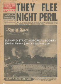
Newspaper - Newspaper articles, Sun News-Pictorial, They Flee Night Peril, The Sun News-Pictorial, Wednesday, January 17, p1, 1962
Various news articles pertaining to the January 1962 Victorian bushfires in the Dandenong and Healesville districts which by the third day had encompassed large areas of the State. Specific Eltham Shire districts mentioned include Panton Hill and Hurstbridge on page 1, Warrandyte on page 2, 3, 4 and 5, Hurstbridge, Smith’s Gully, Kinglake on page 3 and 4, Strathewen, Kangaroo Ground, Panton Hill, St. Andrews, Smith’s Gully on page 4 and Pound Bend, Smith’s Gully and Warrandyte on pages 20-21 • They Flee Night Peril, p1 (Illust.) • Their grim picnic; A flash fire strikes, p2 (Illust.) • Night of terror as towns quitted, p3 • Fought till he dropped, p3 (Illust.) • Rain in fire area, p3 • Wye River town goes, p3 • Black Friday Hero Dies In Fire; with wife, grandsons, p4 • Surrounded!, p4 (Illust.) • Main street houses ablaze, p4 • Hurstbridge is evacuated, p4 • Scores jump in river at Warrandyte, p5 • Hills people leave homes, p5 • “Fire” cry at Parlt., p5 • Blind – he’s safe now, p5 (Illust.) • Police Chief Runs Battle, p7 • From Fire Front: Hospital treats 34, p7 • Firms send help, p7 • Tragedy and Ruin: Third Day; Ferntree Gully; Warrandyte; Pound Bend; Smiths Gully; Escape for 18, pp20-21 (Illust.) • Church was a haven for the hurt, weary, p39 (Illust.) • A home is lost, p40 (Illust.) tom fielding collection, victorian bushfires - 1962, victorian bushfires – 1962, panton hill, hurstbridge, five ways crossroads, warrandyte south, dandenongs, upwey, mt. evelyn, monbulk, olinda, sassafras, st. andrews, warrandyte, christmas hills, yarra river, mitcham, whitehorse roiad, donvale, park orchards, metropolitan fire chief, w.t. aldridge, loughnan’s hill, ringwood, woori yallock, leslie ockwell, linda ockwell, kalorama, healesville, daylesford, fire damage – buildings, wye river, portland, eganstown, ballarat, sherbrooke park forest, forest commission headquarters, kallista, r.t. seaton, montrose, yallourn, central gippsland, smith’s creek, black friday, geoffrey ockwell, ronald ockwell, preston town hall, e.j. tenner, strathewen, kangaroo ground, eric farnsworth, adele farnsworth, robin farnsworth, roy cleland, ann cleland, belgrave, sassfras, kaloramalice commissioner porter, mansfield, box hill hospital, pound bend, ferntree gully, ferntree gully state school, w. carew, ann quinton -
 Eltham District Historical Society Inc
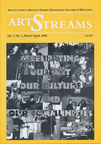
Journal, Peter Doughtery, ArtStreams: Arts & Culture in Banyule, Darebin, Manningham, Nillumbik and Whittlesea; Vol. 5, No. 1, Mar-Apr 2000, 2000
Vol. 5, No. 1, Mar-Apr 2000 CONTENTS ON THE ROAD The Car at Heide 3 ON TOP OF THE WORLD Dandenong Ranges Folk Festival 5 INTERVIEW Felicity Gordon 7 SOUNDS OF HARMONY Gyuto Monks in Eltham 10 BANYULE FESTIVAL 13 WERE ST HILL CLIMB 15 BOROONDARA WRITERS' FESTIVAL 16 WARRANDYTE VILLAGE FESTIVAL 18 DIAMOND CREEK TOWN FAIR 19 TEMPLESTOWE VILLAGE FESTIVAL 20 RECIPES From leading Chefs 21 CAIRO TO CRACOW Middle Eastern Music at Montsalvat 22 POETRY 23 FESTIVAL OF KITES 24 BOOK REVIEW By Michele Lonsdale 25 CD REVIEWS 27 ARTIN ABOUT 28 WINING & DINING 30 ARTISTS SERVICES 32 "Peter Dougherty has been involved in the local art scene for many years. As publisher and editor of the arts magazine Artstreams, his comments on the various branches of the arts are widely respected. His "The Arts" column in the Diamond Valley Leader presents a brief summary for a much wider cross section of the local community. Peter also operates his own gallery and the Artstreams Cafe at the St Andrews market. Peter has a wealth of knowledge about present day and historical aspects of local art and artists." - Eltham District Historical Society Newsletter No. 161, March 2005Colour front and back cover with feature articles and literary pieces with photographs and advertisements printed in black and white. 36 pages, 30 cm. Vol. 1, no. 1 (Nov. 1996) - Vol. 10, no. 5 (summer ed. 2005/06) art streams, carly young, plenty views golf park, dynamic vegies, dandenong ranges folk festival, felicity gordon, sounds of global harmony, banyule festival, rosanna fire station community house, bulleen art & garden centre, were street cafe, were street hill climb, bahnhof cafe, walkers wheels, peter glass, eltham wiregrass gallery, boroondara writers festival, warrandyte festival, diamond creek town fair, templestowe village festival, willy wonkas ice cream, gourmet food, ciaro to cracow, fleur de feliss florist, mia mia gallery, festival of kites, bi-wize quality paints, kinglake gallery, andy cowan, wild dog hill studio, montsalvalt, ian collard, geoff achison, bridget allen, thompsons pharmacy, volumes -
 Eltham District Historical Society Inc
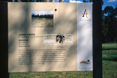
Slide - Photograph, Moonrise, Jane Price, Heidelberg School Artists Trail, Diamond Creek, c.Nov. 2001
The Heidelberg School Artists' Trail extends from Heidelberg through Eltham and Warrandyte and to the Dandenongs. It features signs depicting paintings of artists in the location in which they were painted. Transcription of sign: Jane Price is best known for her small moody impressionistic landscapes, many of which depict the rising moon and capture the softness of the evening twilight. In 1889, she shared a studio in Grosvenor Chambers, Collins Street east, Melbourne, with fellow Heidelberg School artists, Clara Southern and Jane Sutherland. She was also a close friend of Tom Roberts and Frederick McCubbin. Around the time of the First World War, and for several years after, she rented a ‘log cabin’ in Diamond Creek, and this was situated close to ‘The Shack’, the studio and home, of May Vale. Part of a slide show presentation "A Trip Down the Diamond Creek" by Russell Yeoman to the Eltham District Historical Society meeting of 14 Nov. 200135mm colour positive transparency Mount - Black and Whiteart in public places, diamond creek, heidelberg school artists trail, jane price, moonrise, public art, sign