Showing 3774 items
matching digital collections
-
 Bendigo Military Museum
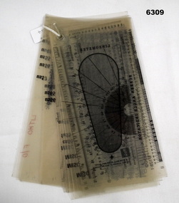
Equipment - Font -Type Style and Point Size Guide, Royal Australian Survey Corps, Circa 1991
Also referenced in the Collections Victoria Bendigo RSL item 6300 Lithographic Squadron Equipment Handbook 1991. Commonly called a type styles guide, used for the selection and editing of text styles and size in mapping.20 Sheets of 21 x 11 cm clear photographic film (connected in the Top left hand corner) depicting various Type Font Styles and Point Sizes including special characters. It also contains a digital Type gauge, a linometer and a screen angle Indicator. royal australian survey corps, rasvy, fortuna, army survey regiment, army svy regt, asr -
 Eltham District Historical Society Inc
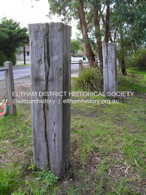
Photograph, Fay Bridge, Old posts, location TBC, 11 June 2019
fay bridge collection, 2019-06-11 -
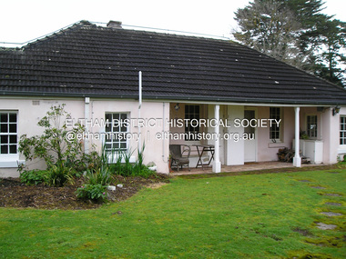
 Eltham District Historical Society Inc
Photograph, Fay Bridge, Rosehill Homestead, EDHS Heritage Excursion, 6 July 2019
July Excursion July 6, 2019 - Exploring Lower Plenty The predominant feature of this walk in the Bonds Road area, Lower Plenty is the large number of magnificent old River Red Gums that line the route. These trees are of the spreading woodland form of this species indicating that they must have been originally growing in a reasonably open setting. The walk also includes parts of the historic Cleveland Estate and the homestead “Rosehill” established by pioneer farmer Henry Stooke. This area was the site of the first recorded European settlement in what was to become the Shire of Eltham when the Willis brothers arrived in the late 1830s. From the southern part of Cleveland Avenue there are extensive views across and along the Yarra Valley. An article on the history of this area was contained in Newsletter edition 201, November 2011. The walk will start at the at the corner of Bonds and Stawell Roads, Lower Plenty - EDHS Newsletter No. 246 June 2019fay bridge collection, 2019-07-06, blackburn bricks, eltham district historical society, heritage excursion, rosehill homestead, lower plenty -
 Eltham District Historical Society Inc
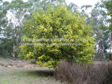
Photograph, Fay Bridge, Wattle tree, Sweeneys Flats, Eltham, 26 August 2019
fay bridge collection, sweeneys flats, wattle tree, 2019-08-26 -
 Eltham District Historical Society Inc
Photograph, Fay Bridge, United Service Station, Main Road, Eltham, 26 August 2019
fay bridge collection, 2019-08-26, cockatoos, diamond street, eltham, luck street, main road, united service station -
 Eltham District Historical Society Inc
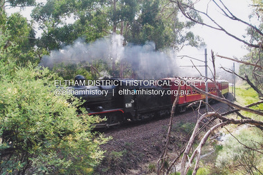
Photograph, Fay Bridge, United Service Station, Main Road, Eltham, 26 August 2019
fay bridge collection, 2019-08-26, hurstbridge wattle festival, k-153, k-class steam locomotive (vr newport workshops), steam locomotive, steamrail victoria -
 Eltham District Historical Society Inc
Photograph, Fay Bridge, EDHS Heritage Excursion, Culla Hill, Sweeneys Lane, Eltham, 7 September 2019
September Excursion - Culla Hill Walk Pioneer Eltham farmer Thomas Sweeney (1803 - 1867) named his house, “Culla Hill” after the area in Ireland that he came from. His house, now called “Sweeneys”, remains on a ridge line overlooking the Yarra River. It is recorded that Thomas Sweeney did well out of carting potatoes and other supplies to the various gold fields such as Bendigo, McIvor (Heathcote), Mount Alexander and Beechworth. Culla Hill is now the name of the road providing access to subdivided lots of the former Sweeney property. The Culla Hill walk will start at the corner of Kent Hughes and Lavender Park Roads, Eltham (Melway ref. 22 A9) at 2.00pm on Saturday 7th September. - EDHS Newsletter No. 247 August 20192019-09-07, activities, culla hill, eltham, eltham district historical society, fay bridge collection, heritage excursion, sweeneys lane -
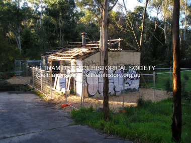 Eltham District Historical Society Inc
Photograph, Fay Bridge, Warrandyte cool store, 9 September 2019
Remains of the old Warrandyte Dairy — Originally constructed to store milk for delivery from Mapleoak Dairies, delivered by the Bellinger family, up until the early 1970s. The Warrandyte Dairy closed in 1987 before the land and building was purchased by Melbourne Water in 1988 to reduce flood risk to the community and preserve riverside land from development on the site which sits on the Yarra River flood plain. In 2017, through a partnership with Manningham City Council, Warrandyte Historical Society and the Warrandyte Community Association, Melbourne Water renovated the 73-year-old site and installed interpretive signs detailing its history for the community.2019-09-09, fay bridge collection, warrandyte cool store, warrandyte dairy -
 Eltham District Historical Society Inc
Photograph, Fay Bridge, Allwood House, Hurstbridge, 9 September 2019
fay bridge collection, 2019-09-09, allwood house, hurstbridge -
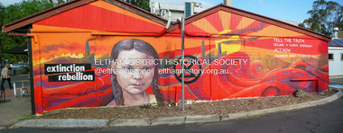 Eltham District Historical Society Inc
Photograph, Fay Bridge, Extinction Rebellion protest mural, Platform 3095, 965 Main Road, Eltham, 29 January 2020
Extinction Rebellion protest mural painted on the western wall of Platform 3095 cafe facing the railway station Prior to September 2016 a grouping of five trees were planted in the small garden bed on the western end of the cafe in two groups either side of the traffic sign which at that stage was the taller By October 2017 the five trees had doubled in height to about 1m above the roof line By April 2018 the trees were all about 2m above the roof line By August 2019 all five trees had been cut down and the wall was a mixture of paint patches from ongoing graffitti attacks By January 2020 the wall had been adorned with this mural which appears to have discouraged ongoing graffitti attacks but its message is tinged with irony that five healthy young trees were removed fay bridge collection, 2020-01-29, eltham, platform 3095, extinction rebellion -
 Eltham District Historical Society Inc
Photograph, Fay Bridge, Former cottage of Tom Ellis, 230 Kangaroo Ground-St Andrews Road, Kangaroo Ground, 13 November 2021
Tom Ellis was the great grandson of pioneer William Ellisfay bridge collection, 2021-11-13, kangaroo ground, kangaroo ground-st andrews road, tom ellis house -
 Eltham District Historical Society Inc
Photograph, Jim Connor, Opportunity Shop, Eltham - Montmorency Uniting Church Hall, 810 Main Rd, Eltham, 7 May 2016
The Society conducted a heritage excursion "Eltham War Memorials Walk" on Saturday, May 7, 2016 in conjunction with the centenary commemorations of the First World War. This walk involved visiting a number of memorials along Main Road dedicated to locals who served Australia in times of war including the Roll of Honour located in the Uniting Church Hall which also serves as the Opportunity Shop, which had once operated out of the former CBA bank building next door.activities, eltham district historical society, heritage excursion, jim connor collection, opportunity shop, uniting church, uniting church hall, 2016-05-07 -
 Eltham District Historical Society Inc
Photograph, Jim Connor, Eltham - Montmorency Uniting Church, 810 Main Rd, Eltham, 13 July 2018
jim connor collection, uniting church, 2018-07-13 -
 Eltham District Historical Society Inc
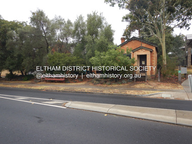
Photograph, Jim Connor, Former CBA branch, 810 Main Rd, Eltham, 6 January 2000
The little yellow and orange brick at 810 Main Road, Eltham, just in front of the Uniting Church (formerly Methodist Church) on the corner of John Street in more recent times has been used as an Opportunity Shop by the Eltham Uniting Church however the operations outgrew the tiny building and the shop moved to inside the Church hall. This building was once the Eltham agency of the Commercial Bank of Australia. Measuring just 3.6 x 4.5 m inside, it was built in 1878 by George Stebbing and is said to have stored gold in the early Eltham-Research mining days. It was also once the scene of an armed hold-up. Thursday, December 15, 1949, the quiet little bank was embroiled in an infamous wild shoot-out between a daring thief and two bank officers. Today, the building still carries the scars ; a bullet hole remains visible in a cedar bench testifying to the events that played out that day.jim connor collection, uniting church, main road, eltham, cba bank, opportunity shop, 2020-01-06 -
 Eltham District Historical Society Inc
Photograph, Jim Connor, Former CBA branch, 810 Main Rd, Eltham, 10 July 2023
The little yellow and orange brick at 810 Main Road, Eltham, just in front of the Uniting Church (formerly Methodist Church) on the corner of John Street in more recent times has been used as an Opportunity Shop by the Eltham Uniting Church however the operations outgrew the tiny building and the shop moved to inside the Church hall. This building was once the Eltham agency of the Commercial Bank of Australia. Measuring just 3.6 x 4.5 m inside, it was built in 1878 by George Stebbing and is said to have stored gold in the early Eltham-Research mining days. It was also once the scene of an armed hold-up. Thursday, December 15, 1949, the quiet little bank was embroiled in an infamous wild shoot-out between a daring thief and two bank officers. Today, the building still carries the scars ; a bullet hole remains visible in a cedar bench testifying to the events that played out that day.jim connor collection, uniting church, main road, eltham, cba bank, opportunity shop, 2023-07-10 -
 Eltham District Historical Society Inc
Photograph, Jim Connor, Eltham - Montmorency Uniting Church, 810 Main Rd, Eltham, 10 July 2023
Located on the corner of Main Road and John Street, the church first served the community as the Eltham Wesleyan Church since 1881. It became the Eltham Methodist Church in 1902, the year it united with the Primitive Methodists. Eltham Wesleyans first worshipped together in the home of William and Mary Crozier, on 24 acres bounded by Mount Pleasant Road and Pitt Street. From there they moved to a slab and bark hut in 1855 (this later served as the first school run by David Clark prior to the building of a new school in Dalton Street) and the members then built a chapel in 1858 on Lot 20, Henry Street (later to become the Rechabite Hall and Eltham Public Hall). The present church on John Street was designed by architects Crouch and Wilson in the Early English Gothic style with biochrome brick window frames, buttress heads and pinnacle. Church member George Stebbing built the church, the foundations were constructed with stone from the walls of the first Eltham State Primary School (No. 209) building which collapsed in 1874 and were purchased by Robert David Taylor. Stebbing was also responsible for building St Margaret’s Church and Shillinglaw Cottage. The Roll of Honour, which presently hangs in the church hall (which also doubles as the Opportunity Shop) lists 27 members of the congregation who served in the First World War, 11 of whom never returned. The red-brick Church Hall was opened in 1931 and in 1971 further additions linked the hall and church, including a foyer, vestry, meeting room and toilets reflecting the Eltham style of that time with its simplicity, extensive clear glass, reused baked clay-bricks from the 1881 church, heavy ceiling beams and compressed straw ceiling. On June 26, 1977, the church became part of the new Uniting Church in Australia consisting of the former Methodist and Congregational and most of the Presbyterian Churches. Following of declining numbers of worshippers, the church merged with the Montmorency Uniting Church on June 23, 1996. In 2023 the Uniting church approved a plan to renovate the church. It is understood that the historic church and the hall will be retained, and the building added in 1971 is to be demolished, to make way for a new purpose-built Opportunity shop. The proposed areas to be demolished include the current foyer, toilets, crèche, etc, including the area between the hall and the former RSL. Works are expected to commence mid to late July 2023. The Society was invited by a church member to take photographs of these areas to document them prior to demolition works commencing. Ref: “Nillumbik Now and Then” by Marguerite Marshall (2008)jim connor collection, 2023-07-10, eltham-montmorency uniting church, john street, methodist church, opportunity shop, uniting church, uniting church hall -
 Eltham District Historical Society Inc
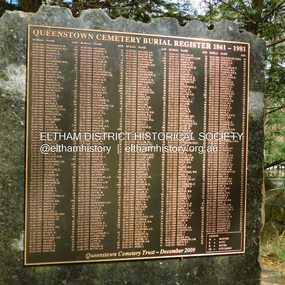
Photograph, Jim Connor, Queenstown Cemetery Burial Register 1861-1981, Queenstown Cemetery, Smiths Gully Road, St Andrews, 8 March 2023
Installed by the Queenstown Cemetery Trust December 2009 The discovery of gold in Smyth's Creek in 1854 and subsequent gold rush to the Caledonia diggings led to the establishment of Queenstown (present day St Andrews). The first recorded burial was July 31st, 1861 and it was officially declared a Cemetery Reserve in 1866. Many graves are unmarked and unrecorded including many Chinese and other itinerant miners. The cemetery was closed for new burials in 1851. The last recorded burial was in 1981 in an existing family grave.jim connor collection, 2023-03-08, queenstown cemetery, smiths gully road, st andrews -
 Eltham District Historical Society Inc
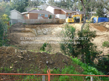
Photograph, Daryl Morrow, Redevelopment of former site of Hassall's Roadside Gallery, Main Road, Eltham, 10 July 2023
This historic site of Australia’s first open-air gallery is being redeveloped in 2023 for multi-housing fronting the Research Creek. In 1955, Ian and Joan Hassall moved to Eltham. They took a property on the corner of Zig Zag Road and Main Road, Eltham, north of the township (later known as 1215 Main Road). In July 1962, they opened their open-air gallery. Hassall’s Roadside Galley, “…cradled in the fold of hills to the north of Eltham” inspired by Ian’s own experience of exhibitions along the Embankment in London. The property included remnants of a stone quarry, paintings were hung on screens and removed at night. Various pedestals, that looked like giant mushrooms displayed sculpture, pottery, and jewellery. It had a small natural amphitheatre at the foot of a little sandstone cliff that fall away to the bed of a stream. To enter the gallery, a visitor crossed a small freestone bridge of oriental design, built by Hassall from local stone. The bridge spanned the stream flowing beneath great willow trees. Near the entrance wooden figures were displayed formed from pieces of local wood, said to speak to Ian Hassall’s sense of fun. Hassall’s Gallery was the first gallery of its kind in Australia. Ian became a full-time artist and when it first opened, he exhibited paintings he had made while touring the outback with writer and fellow Eltham resident Alan Marshall. He also exhibited other Australian artists over time including locals Lindsay Edward and Peter Glass.daryl morrow collection, eltham heights luxury living, hassalls roadside gallery, housing development, real estate development, research creek, 2023-07-10 -
 Eltham District Historical Society Inc
Photograph, Daryl Morrow, Redevelopment of former site of Hassall's Roadside Gallery, Main Road, Eltham, 13 July 2023
This historic site of Australia’s first open-air gallery is being redeveloped in 2023 for multi-housing fronting the Research Creek. In 1955, Ian and Joan Hassall moved to Eltham. They took a property on the corner of Zig Zag Road and Main Road, Eltham, north of the township (later known as 1215 Main Road). In July 1962, they opened their open-air gallery. Hassall’s Roadside Galley, “…cradled in the fold of hills to the north of Eltham” inspired by Ian’s own experience of exhibitions along the Embankment in London. The property included remnants of a stone quarry, paintings were hung on screens and removed at night. Various pedestals, that looked like giant mushrooms displayed sculpture, pottery, and jewellery. It had a small natural amphitheatre at the foot of a little sandstone cliff that fall away to the bed of a stream. To enter the gallery, a visitor crossed a small freestone bridge of oriental design, built by Hassall from local stone. The bridge spanned the stream flowing beneath great willow trees. Near the entrance wooden figures were displayed formed from pieces of local wood, said to speak to Ian Hassall’s sense of fun. Hassall’s Gallery was the first gallery of its kind in Australia. Ian became a full-time artist and when it first opened, he exhibited paintings he had made while touring the outback with writer and fellow Eltham resident Alan Marshall. He also exhibited other Australian artists over time including locals Lindsay Edward and Peter Glass.daryl morrow collection, eltham heights luxury living, hassalls roadside gallery, housing development, real estate development, research creek, 2023-07-13 -
 Eltham District Historical Society Inc
Photograph, Fay Bridge, Ancient Eel trap on the Yarra River at Laughing Waters, Eltham - pre-dating European settlement, 6 September 2023
Laughing Waters is the name for a stretch of the Yarra Valley Parklands consisting of river flats and hilly riparian bushland. With Birrarung (Yarra River) flowing through, Laughing Waters has been an important gathering place for thousands of years. For the Wurundjeri, ‘Garambi Baan’ (the name for Laughing Waters in Woi wurrung) is an important site for growing and harvesting food. Significantly, Wurundjeri iuk (eel) traps remain at Garambi Baan to this day. The Wurundjeri Woi Wurrung People take their name from the Woi wurrung language word ‘wurun’ meaning the Manna Gum (Eucalyptus viminalis) which is common along ‘Birrarung’ (Yarra River), and ‘djeri’, the grub which is found in or near the tree. Wurundjeri are the ‘Manna Gum People’ and their Ancestors have lived on this land for millennia. The site on the Yarra River near the former Morrison property Killeavey was given a language name in 2015 at the instigation of Wurundjeri Elder, Dave Wandin. Garambi Baan means “laughing waters” in the traditional language, Woi wurrung. The site at Warrandyte was rediscovered by Campbell Beardsell OAM in 2007 and is one of only a few known remaining iuk (eel) traps on Country once found the length of the Birrarung (Yarra) and the Maribyrnong. Original Indigenous aquacultural infrastructure was dismantled, taken away from sites and used to build houses, fords and roads by Europeans. The difficult and restricted access to this site is thought to be one of the reasons for its survival. The iuk trap is located within lands managed by Parks Victoria. The Narrap team in partnership with Parks Victoria and Acacia Land Management have been improving the native vegetation with a program of woody weed removal, exclusion fencing and revegetation. Importantly, the team have restored the trap’s infrastructure and have demonstrated its effectiveness.” References: Wurundjeri Woi Wurrung Cultural Heritage Aboriginal Corporation - Laughing Waters. (2023, September 3). Retrieved from https://inplace.org.au/laughing-waters/ GARAMBI BAAN LAUGHING WATERS RESIDENCY CENTRE 2020 2024 Strategic Plan, Nillumbik Shire Council (2023, September 3). Retrieved from https://www.nillumbik.vic.gov.au/files/assets/public/minutes-and-agendas/2020/09-sep/15-sep-cm/ocm.177-20-attachment-1-laughing-waters-arts-program_1.pdffay bridge collection, eel trap, laughing waters, yarra river, wurundjeri woi wurrung, garambi baan, 2023-09-06 -
 Eltham District Historical Society Inc
Photograph, Fay Bridge, EDHS Heritage Walk: Shillinglaw Farm, Eltham, 2 September 2023
On Saturday September 2, 2023, Russell Yeoman led a group of 22 society members and interested others on a walk following trhe bounadries of the original Shillingalw farm. Commencing at the corner of Panther Place and Library Place, we proceeded up to Shillinglaw Cafe then the Shillinglaw trees at the former Eltham Shire Office site then along Main Road to the fire station then throughh St Laurence Lane and uinder the railway line , along Diamond Street then return via the Diamond Creek trail behind Andrew Park. The actual farm boundary went past the creek and further up the hill. The original farm comprised lot 90 of Holloway’s 1851 subdivision of Little Eltham. Its area was 30 acres lying east of the Diamond Creek and north of Henry Street. A number of stops were made to look at maps and early photos illustrating the gradual reduction of the farm area and the early history of the railway and other community uses, that occupied parts of the site.fay bridge collection, 2023-09-02, activities, eltham, eltham district historical society, heritage excursion, shillinglaw farm -
 Eltham District Historical Society Inc
Photograph - Aerial Photograph, Landata, Eltham / Research, Vic, Jan. 1951
Centred on Brinkkotter Road opposite Yarramie Reserve, Eltham bounded by Maroondah Aqueduct to north, Nyora Road to south, Eltham College to east and Leane Drive to west. Historic Aerial Imagery Source: Landata.vic.gov.au Aerial Photo Details: Project No :65 Project : MELBOURNE AND METROPOLITAN PROJECT NO. 2 Run : 7 Frame : 8 Date : 01/1951 Film Type : B/W Camera : EAG9 Flying Height : 12200 Scale : 12000 Film Number : 1419 GDA2020 : 37°42'32"S, 145°10'41"E MGA2020 : 339408, 5824924 (55) Melways : 22 F3 (ed. 42)Historical aerial photos and photo maps provide viusal evidence of the chronology of changes to the built landscape of the district and assist in dating other imagesaerial photo, 1951-01, eltham, neil webster collection, brinkkotter road, eltham college, leane drive, maroondah aqueduct, melways 22f3, nyora road, yarramie reserve -
 Eltham District Historical Society Inc
Photograph - Aerial Photograph, Landata, Eltham, Vic, Jan. 1951
Centred on Beard Street between Main Road and Frank Street, Eltham bounded by Maroondah Aqueduct to north, Arthur Street to south, Maroong Drive to east and Catholic Ladies College to west. Historic Aerial Imagery Source: Landata.vic.gov.au Aerial Photo Details: Project No :65 Project : MELBOURNE AND METROPOLITAN PROJECT NO. 2 Run : 7 Frame : 9 Date : 01/1951 Film Type : B/W Camera : EAG9 Flying Height : 12200 Scale : 12000 Film Number : 1419 GDA2020 : 37°42'23"S, 145°09'39"E MGA2020 : 337874, 5825170 (55) Melways : 22 B3 (ed. 42)Historical aerial photos and photo maps provide viusal evidence of the chronology of changes to the built landscape of the district and assist in dating other imagesaerial photo, 1951-01, eltham, neil webster collection, arthur street, beard street, catholic ladies college, frank street, main road, maroondah aqueduct, maroong drive, melway 22b3, research (vic.) -
 Eltham District Historical Society Inc
Photograph - Aerial Photograph, Landata, Eltham, Vic, Jan. 1951
Centred on Allison Crecent Reserve, Sherbrook Road and Scenic Crescent, Eltham bounded by Allendale Road to north, Dudley Street to south, Zig Zag Road to east and St Helena Road to west. Historic Aerial Imagery Source: Landata.vic.gov.au Aerial Photo Details: Project No :65 Project : MELBOURNE AND METROPOLITAN PROJECT NO. 2 Run : 7 Frame : 10 Date : 01/1951 Film Type : B/W Camera : EAG9 Flying Height : 12200 Scale : 12000 Film Number : 1419 GDA2020 : 37°42'14"S, 145°08'36"E MGA2020 : 336339, 5825416 (55) Melways : 21 H2 (ed. 42)Historical aerial photos and photo maps provide viusal evidence of the chronology of changes to the built landscape of the district and assist in dating other imagesaerial photo, 1951-01, eltham, neil webster collection, allendale road, allison crecent reserve, dudley street, melway 21h2, scenic crescent, sherbrook road, st helena road, zig zag road -
 Eltham District Historical Society Inc
Photograph - Aerial Photograph, Landata, Eltham North, Feb. 1956
... Montmorency Neil Webster Collection Digital jpg and electronic PDF ...Centred on present day 54 Kelway Crescent, Eltham North bounded by Glen Gully Road to north, Meruka Drive to south, Eltham College to east and Leach Street to west. Historic Aerial Imagery Source: Landata.vic.gov.au Aerial Photo Details: Project No :250 Project : MELBOURNE OUTER SUBURBS PROJECT Run : 17 Frame : 113 Date : 02/1956 Film Type : B/W Camera : EAG9 Flying Height : 10000 Scale : 12000 Film Number : 1176 GDA2020 : 37°42'16"S, 145°08'08"E MGA2020 : 335650, 5825336 (55) Melways : 21 G2 (ed. 42)aerial photo, 1956-02, eltham, eltham north, glen gully road, leach street, main road, melway 21g2, meruka drive, montmorency, neil webster collection -
 Eltham District Historical Society Inc
Photograph - Aerial Photograph, Landata, Montmorency, Feb. 1956
Centred on present day Tahlee Place Reserve and Sherbourne Preschool, Montmorency bounded by Progress Road to north, Withers Way to south, Main Road to east and Leach Street to west. Historic Aerial Imagery Source: Landata.vic.gov.au Aerial Photo Details: Project No :250 Project : MELBOURNE OUTER SUBURBS PROJECT Run : 17 Frame : 114 Date : 02/1956 Film Type : B/W Camera : EAG9 Flying Height : 10000 Scale : 12000 Film Number : 1176 GDA2020 : 37°42'50"S, 145°08'02"E MGA2020 : 335512, 5824286 (55) Melways : 21 F5 (ed. 42)aerial photo, 1956-02, neil webster collection, central park, eltham, leach street, main road, melway 21f5, montmorency, progress road, withers way, sherbourne preschool, tahlee place reserve -
 Eltham District Historical Society Inc
Photograph - Aerial Photograph, Landata, Montmorency, Feb. 1956
Centred on present day Grand Boulevard and Olympic Way, Montmorency bounded by Diamond Street to north, Old Eltham Road and Eltham Lower Park to south, Bible Street to east and Para Road to west. Historic Aerial Imagery Source: Landata.vic.gov.au Aerial Photo Details: Project No :250 Project : MELBOURNE OUTER SUBURBS PROJECT Run : 17 Frame : 115 Date : 02/1956 Film Type : B/W Camera : EAG9 Flying Height : 10000 Scale : 12000 Film Number : 1176 GDA2020 : 37°43'24"S, 145°07'55"E MGA2020 : 335375, 5823236 (55) Melways : 21 F7 (ed. 42)aerial photo, 1956-02, neil webster collection, eltham, main road, montmorency, bible street, diamond street, eltham lower park, grand boulevard, melway 21f7, old eltham road, olympic way, para road -
 Eltham District Historical Society Inc
Photograph - Aerial Photograph, Landata, Lower Plenty, Feb. 1956
Centred on present day 217 Old Eltham Road, Lower Plenty bounded by Pitt Street to north, Yarra River to south, Main Road to east and Bonds Road to west. Historic Aerial Imagery Source: Landata.vic.gov.au Aerial Photo Details: Project No :250 Project : MELBOURNE OUTER SUBURBS PROJECT Run : 17 Frame : 116 Date : 02/1956 Film Type : B/W Camera : EAG9 Flying Height : 10000 Scale : 12000 Film Number : 1176 GDA2020 : 37°43'58"S, 145°07'49"E MGA2020 : 335237, 5822186 (55) Melways : 21 E10 (ed. 42)aerial photo, 1956-02, neil webster collection, eltham, main road, bonds road, elham, lower plenty, melway 21e10, pitt street, yarra river -
 Eltham District Historical Society Inc
Photograph - Aerial Photograph, Landata, Eltham, Feb. 1956
Centred on present day Culla Hill and Petty's Orchard, Eltham bounded by Brougham Street and Mount Pleasant Road to north, Monckton Road, Templestowe to south, Reynolds Road to east and Eltham Lower Park and Hohnes Road to west. Historic Aerial Imagery Source: Landata.vic.gov.au Aerial Photo Details: Project No :250 Project : MELBOURNE OUTER SUBURBS PROJECT Run : 18 Frame : 92 Date : 02/1956 Film Type : B/W Camera : EAG9 Flying Height : 10000 Scale : 12000 Film Number : 1176 GDA2020 : 37°43'35"S, 145°09'31"E MGA2020 : 337735, 5822959 (55) Melways : 22 B8 (ed. 42)aerial photo, 1956-02, neil webster collection, eltham, brougham steet, culla hill, eltham lower park, hohnes road, melway 22b8, monckton road, mount pleasant road, petty's orchard, reynolds road, sweeneys lane, templestowe, yarra river -
 Eltham District Historical Society Inc
Photograph - Aerial Photograph, Landata, Eltham, Feb. 1956
Centred on present day Mount Plaeasant Road near Dalton Street, Eltham bounded by Luck Street to north, Eltham Lower Park to south, Reynolds Road to east and Central Park to west Historic Aerial Imagery Source: Landata.vic.gov.au Aerial Photo Details: Project No :250 Project : MELBOURNE OUTER SUBURBS PROJECT Run : 18 Frame : 93 Date : 02/1956 Film Type : B/W Camera : EAG9 Flying Height : 10000 Scale : 12000 Film Number : 1176 GDA2020 : 37°43'02"S, 145°09'38"E MGA2020 : 337871, 5823961 (55) Melways : 22 B6 (ed. 42)aerial photo, 1956-02, neil webster collection, eltham, central park, eltham lower park, luck street, melway 22b6, nyora road, reynolds road, dalton street, mount pleasant road