Showing 1583 items
matching documents - maps
-
 Eltham District Historical Society Inc
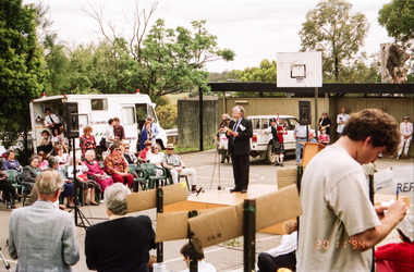
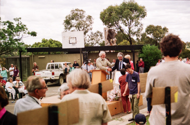
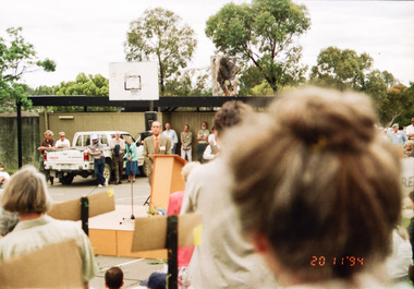
Photograph, Opening of Andrew Ross Museum, Kangaroo Ground, 20 Nov 1994, 20/11/1994
... focused on documents, maps and photographs, etc.... focused on documents, maps and photographs, etc. shire of eltham ...In 1992 Shire of Eltham Historical Society member and Kangaroo Ground resident, Bruce Ness became aware that the old school teacher residence at Kangaroo Ground School was no longer being used. Over the years Bruce had been storing a growing collection of the Society's artifacts and objects including various machinery and farm tools. He proposed that this might present an opportunity to set up a museum with the Society's objects. It was proposed that a board be appointed containing representatives of the Society, the School Council, Shire of Eltham and "Friends of the Andrew Ross Museum." As a consequence, most of the Society's objects were transferred to the museum and the Society became more focused on documents, maps and photographs, etc.Roll of 35mm colour negative film, 3 stripsFuji 100shire of eltham historical society -
 Eltham District Historical Society Inc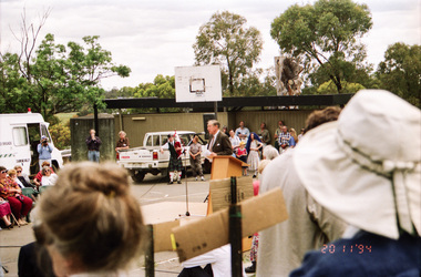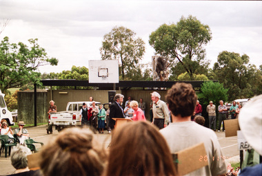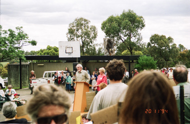
Photograph, Opening of Andrew Ross Museum, Kangaroo Ground, 20 Nov 1994, 20/11/1994
... focused on documents, maps and photographs, etc.... focused on documents, maps and photographs, etc. shire of eltham ...In 1992 Shire of Eltham Historical Society member and Kangaroo Ground resident, Bruce Ness became aware that the old school teacher residence at Kangaroo Ground School was no longer being used. Over the years Bruce had been storing a growing collection of the Society's artifacts and objects including various machinery and farm tools. He proposed that this might present an opportunity to set up a museum with the Society's objects. It was proposed that a board be appointed containing representatives of the Society, the School Council, Shire of Eltham and "Friends of the Andrew Ross Museum." As a consequence, most of the Society's objects were transferred to the museum and the Society became more focused on documents, maps and photographs, etc.Roll of 35mm colour negative film, 3 stripsFuji 100shire of eltham historical society -
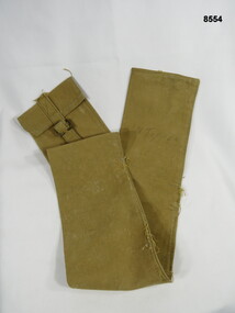 Bendigo Military Museum
Equipment - CARRY BAG, Unknown
... to carry maps or documents.... maps or documents. Equipment CARRY BAG ...Long narrow khaki holdall carry bag, most likely used to carry maps or documents.N. TUPPERpasschendaele barracks trust, holdall, carry bag -
 Bendigo Historical Society Inc.
Document - GOLDEN GULLY ALLUVIAL WORKINGS
... number 1.1. Document has map/grid references, parcel number... 1.1. Document has map/grid references, parcel number ...Golden Gully alluvial workings, Diamond Hill area, site number 1.1. Document has map/grid references, parcel number and location - runs along Woodward Road. History from 1851 to 186 detailed. . Information from David Bannear's Bendigo goldfields survey. -
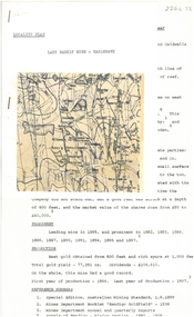
 Bendigo Historical Society Inc.
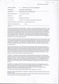
Document - ALBERT RICHARDSON COLLECTION: LADY BARKLY MINE, EAGLEHAWK
... One page document, plus map, with information on the Lady...BENDIGO Mining lady barkly mine eaglehawk One page document ...One page document, plus map, with information on the Lady Barkly Mine, New Chum line of reef, Eaglehawk. The location, early history, prominence, and gold production are described. References given on bottom of document. Document forms part of research referred to in Albert Richardson's paper 2264.70.bendigo, mining, lady barkly mine eaglehawk -
 Melbourne Tram Museum
Map, Melbourne & Metropolitan Tramways Board (MMTB), MMTB Route Maps, 1979
... containing both bound and unbound maps and documents.... covers containing both bound and unbound maps and documents. MMTB ...Series of colour maps for various tram and bus routes, dated 1979. Also contained, not scanned are letters, reports, and specifications for printing these maps for use in shelters etc. Some have the Transport Information Centre telephone printed on them. Some are finished with a plastic laminate finish on either one or both sides. Show the major cross streets, parks, schools, other tram routes, major stop numbers, and railway lines. See also item 3909 for another example of these. Trams 1 - City route guide - R9/77 - showing all route numbers and destinations that passed through the CBD. 2 - Bourke St tram routes - R4/77 - East Brunswick Blyth St and East Preston Tyler St and intermediate routes, routes 95, 96, 97, 90, 89 and 88. 3 - Malvern, East Malvern, Carnegie, and East Brighton Tram Routes (from St Kilda Junction) - R1/79 - shows routes 5, 3, 67, 66, 61, 62, and 64. 4 - Elizabeth St tram routes - R12/77 - Essendon Airport, West Maribyrnong, North Coburg lines, routes 50, 58, 60, 54, 57, 52. 49, 59, 18, 20 and 19 5 - Flinders St tram routes - R5/78 - North Balwyn, East Burwood, routes 48, 40, 41, Hartwell, 28, 74 and 75 6 - Kew - St Kilda Beach - R1/79 - Route 69. 7 - Mont - Albert City - R11/77, shows routes 43. 47. 45. 44 8 - St Kilda Rd Tram Routes R12/77 - details South Melbourne Beach, route 1 and route 2 and St Kilda Beach routes 15, 16, and 55 otherwise shows where the various routes branch off St Kilda Road 9 - Batman Ave tram routes - R9/77 - Wattle Park, North Richmond and Prahran - routes 70, 71, 78 and 79. 10 - Footscray - Moonee Ponds - R3/81 - Route 82 11 - Swanston St tram guide - R1/79 - lists all routes and route numbers that branch or cross Swanston St between Grattan St and St Kilda Junction. 12 - Toorak Camberwell and Glen Iris tram route with Camberwell Junction and Malvern Town Hall, R1/79, routes 8, 7, 6, 72, and 73 shown. 13 - West Preston - Beach tram routes - R12/77 - routes 10, 11, 9 and 12, 14 - William St tram routes - R12/77 - Route 55, 56, and 63 - South Melbourne Depot and Domain. Buses 1 - Footscray, Sunshine, Deer Park, Nth Altona & Fishermans Bend - R2/79 2 - Box Hill bus routes to Templestowe, Heidelberg & East Kew - R6/78 - notes superseded by R3/82 3 - Plan of Russell St Melbourne bus departure bays. 4 - Box Hill, Mitcham & Ringwood bus routes to East Doncaster & Warrandyte - R3/82 5 - City - Warrandyte & East Doncaster bus routes - R3/82 & R6/78 6 - Bulleen - City - Port Melbourne - Garden City Bus route - R6/78 7 - North Altona - City bus route - 11/78 8 - Clifton Hill - Elsternwick - R2/79 9 - La Trobe - Northland - West Heidelberg - City Bus Service via East Freeway - 11/79 and R3/81 10 - Box Hill, Mitcham & Ringwood Bus Routes to East Doncaster & Warrandyte - R10/84 - with the Metropolitan Transit logo.Yields information about tram and bus routes in late 1970s early 1980s.Book - brown comb binding, card and clear plastic covers containing both bound and unbound maps and documents.K C Painter on front cover in ink.tramways, mmtb, tram routes, maps, bus routes, route numbers, routes, route guide -
 Bendigo Military Museum
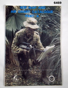
Document - ADF Map and Air Chart Catalogue Part A, RASvy Corps, May 1991
... This document contains the "map and Air Chart Demand...This document contains the "map and Air Chart Demand ...This document contains the "map and Air Chart Demand and Issue Voucher" to enable the ordering of map products. The catalogue of available products is shown on the reverse side to assist in the ordering process.1. A Map sheet of Australia folded to A4 in size. 2. A selection of map examples and a catalogue of products, Tactical Line Maps (TLM) at 1:50,000 scale to Digital Chart of the World (DCW) at 1:1,000,000 scale maps. The names of all the 1:100,000 maps are listed in alphabetical order. 3. The Map and Air Chart Demand and Issue Voucher is printed on the back of the document. 4. Front section has a photo of a soldier with a Steyr rifle kneeling reading a map.royal australian survey corps, rasvy, fortuna, army survey regiment, army svy regt, asr -
 Bendigo Historical Society Inc.
Document - MCCOLL, RANKIN AND STANISTREET COLLECTION: NAPOLEON REEF GOLD MINING CO. N.L, 22 August 1950
... Document: 5 Page legal document with map of lease area... mining gold mining Napoleon Reef Document: 5 Page legal document ...Document: 5 Page legal document with map of lease area, Lease No. 11273 Bendigo, Vol.331, Fol. 36453, 15 year lease from 12 December 1949, in vicinity of Inglis, Harvey & Curnow Streets, Signed by Dallas Brooks, Gov of Victoria & J.J. Stanistreet, Mine Manager.organization, business, industrial - mining, mccoll rankin & stanistreet, mining, gold mining, napoleon reef -
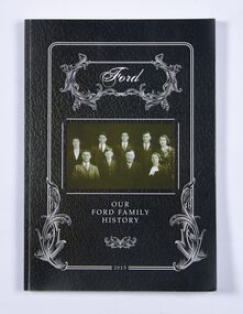 Ballan Shire Historical Society
Book - Book, Ford - Our Ford Family History, 2015
... photographs, family trees, documents, newspaper cuttings, maps... photographs, family trees, documents, newspaper cuttings, maps ...A history of the Ford Family and descendants, pioneer settlers of the Morrisons/Meredith area in Victoria. Contains photographs, family trees, documents, newspaper cuttings, maps, narratives etc. Black and white only.This book is significant in that it contains valuable historic information on the Ford and Brawn families. The publication is private and intended for the information and interest of family members and others researching the family.Book, soft cover, perfect bound, with a leather look cover and a photograph of family members with a scrollwork surround.ford, brawn, bant -
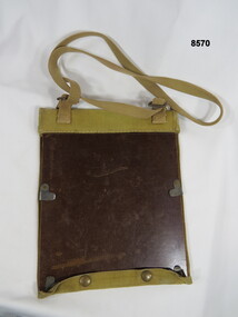 Bendigo Military Museum
Equipment - FIELD CASE, MAP, Unknown
... Maps and documents...Khaki over the shoulder field case for maps or documents...Passchendaele Barracks Trust Field case Maps and documents ...Khaki over the shoulder field case for maps or documents. The backing base is covered in cotton khaki material with bottom press stud closure buttons. Maps or documents are held in place by adjustable slide over clips. On the inside of the cover there are six sewn in narrow pockets for pens, pencils and relevant recording items.passchendaele barracks trust, field case, maps and documents -
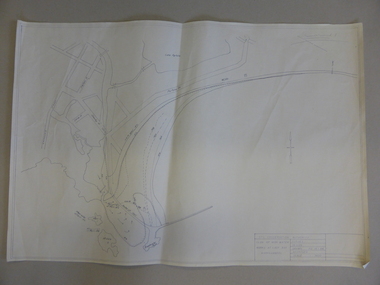 Warrnambool and District Historical Society Inc.
Map, Soil conservation authority:plan of high water marks at Lady Bay Warrnambool, 1984
... This map documents the changing state of Lady Bay from... Street (south of Merri St) Warrnambool great-ocean-road This map ...This map documents the changing state of Lady Bay from around 1870 until 1976. It depicts the changing high water mark over that period and the main outlet of the Merri River in 1872 and 1976.This map provides a useful and significant insight into the ever changing face of Lady Bay from the 1870’s through to 1980’s. Cream paper map drawn with black ink showing Lady Bay and South Warrnambool section of Warrnambool. In lower RH corner Soil conservation AuthorityPlan of High water marks at Lady Bay Warrnambool. Drawn P.D. 19.1/84. Scale 1:3600. Written on back in black pencil: Lady Bay Historical HWM lady bay map, merri river 1872- 1976, merri river 1872- 1976, history of warrnambool -
 Bendigo Military Museum
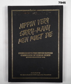
Book - POW SUBMISSION, Queensland Ex-POW Reparation Committee, "NIPPON VERY SORRY - MANY MEN MUST DIE", 1990
... and white phtographs, documents and maps. End papers - front... and white phtographs, documents and maps. End papers - front ...Refer Cat. No. 7944. Item in the collection of "Arthur E. Tranter" V50166 - VX52843 2/29th Bn. P.O.W. From front cover "NIPPON VERY/ SORRY - MANY/ MEN MUST DIE" "SUBMISSION TO THE UNITED NATIONS/ COMISSION OF HUMAN RIGHTS/ (ECOSOC RESOLUTION 1503)". "AUTHORISED BY / THE QUEENSLAND EX- POW REPARATION COMMITTEE".hard cover book. Cover - cardboard with black colour buckram adhered cover with gold colour print front and spine. 123 pages - cut, plain, off white colour paper. Illustrated black and white phtographs, documents and maps. End papers - front and back - illustrated with a diagram of the "BURMA- SIAM RLY".publications, book, military history, ww2, tranter, pow's -
 Bendigo Historical Society Inc.
Document - ALBERT RICHARDSON COLLECTION: NEW RED, WHITE AND BLUE CONSOLIDATED MINE, GOLDEN SQUARE
... Two-page document plus map showing location of the New Red... document plus map showing location of the New Red, White and Blue ...Two-page document plus map showing location of the New Red, White and Blue Consolidated mine on the Sheepshead Line of Reef. Information on the mine is given in the following areas: location plant, early history, its role as a leading mine, its prominence, its closure, gold production. References are provided. Document forms part of research referred to in Albert Richardson's paper 2264.70.bendigo, mining, new red white and blue mine -
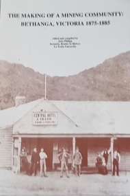 Wodonga & District Historical Society Inc
Book - The Making of a Mining Community: Bethanga, Victoria 1875 - 1885
... pages including images, maps and document extracts.... images, maps and document extracts. The Making of a Mining ...A publication by La Trobe University to support the teaching of V.C.E History Unit 1: Local History. It is presented as 6 investigations focused on aspects of community through a case study of the Upper Bethanga district in Northeast Victoria from 1875 to 1885.A publication by La Trobe University to support the teaching of V.C.E History Unit 1: Local History. It consists of 94 pages including images, maps and document extracts.A publication by La Trobe University to support the teaching of V.C.E History Unit 1: Local History. It is presented as 6 investigations focused on aspects of community through a case study of the Upper Bethanga district in Northeast Victoria from 1875 to 1885.local history, vce resources, bethanga community, bethanga history -
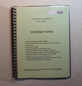 Greensborough Historical Society
Folder, Grimshaw Family, 1849o
... Passenger indexes; maps; mortgage document 1873 Grimshaw... Plenty Lower Plenty melbourne Passenger indexes; maps; mortgage ...Passenger indexes; maps; mortgage document 1873 Grimshaw and Britnell; history of Aaron and Joshua Grimshaw; Greensborough murder: transcript of the trial of Josiah Grimshaw for the murder of John Mitchell.History of the origins of this Greensborough family.20-page plastic binder, spiral bound, clear cover. Contains documents relating to the Grimshaw family.Collected by Greensborough Historical Society. Folder commenced 2012.grimshaw family -
 Bendigo Historical Society Inc.
Document - Map outlining Australia's natural hazard zones
... John Perry collection. Laminated document. Color. Map... Perry collection. Laminated document. Color. Map of Australia ...John Perry collection. Laminated document. Color. Map of Australia in the middle of document surrounded by 10 images of natural disasters that have occurred in Australia in Cairns, Darwin, Cleve, Northam, Central Queensland, Mt. Macedon, Dandenong Ranges, Benalla, Healesville, and Charleville. Legend demonstrates different types of natural disasters and zones in which they are more likely to occur. Has logo of Australian Red Cross at the bottom of document. map, tornado, cyclone, flood, drought, natural disasters -
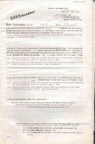 Bendigo Historical Society Inc.
Document - MCCOLL, RANKIN AND STANISTREET COLLECTION: INDENTURE GOLD MINING LEASE 9201 BALLAARAT
... 6 page document plus map: indenture, gold mining lease...BENDIGO Mining Deborah Gold Mines 6 page document plus map ...6 page document plus map: indenture, gold mining lease dated 9th August 1960, between the Crown and North Deborah Mining Company, carrying on operations in the Parish of Moorarbool West . Key on map indicates depth to which land may be excised. On map: Mining District of Ballarat, County of Grant, Parish of Moorarbool West. Total area: 285 acres 1 rood, 20 perches. Vol 334, Fol 202.bendigo, mining, deborah gold mines -
 Bendigo Historical Society Inc.
Document - INDENTURE, GOLD MINING LEASE 11081 CROWN AND HERBERT JACKSON LEED OF BENDIGO, MCCOLL, RANKIN AND STANISTREET COLLECTION, 21st September, 1940
... Six page document plus map, dated 21st September 1940... Joseph Dugan Six page document plus map, dated 21st September ...Six page document plus map, dated 21st September 1940, between the Crown and Herbert Jackson Leed, for the land shown on the accompanying map 'indicated by yellow colour' Depths indicated on lease document. On map: Mining District of Bendigo, County of Bendigo, Parish of Sandhurst. No. 11081. Net Area 24 acres, 3 roods, 3 perches. Signed by Herbert Leed and ?Walsh, Warden Clerk, Bendigo. Map shows lease holding 11081 coloured yellow. Other leases: no's. 9882 11081, 11034, 11080. Streets: Fletcher Street, and Belle Vue Road. Gullies: Derwenters Mistake Bully and Pig Face Gully on lease 11081. Quarry Hill Recreation Reserve marked and some residential allotments. Water race indicated on map. On back of document: ; Deborah United Gold Mining Company No Liability of Charing Cross Bendigo is now the proprietor of the within described estate by transfer registered on 21st November 1940 and numbered 1795202.bendigo, mining, deborah united gold mine, herbert jackson leed, deborah united gold mining. major general sir winston joseph dugan -
 Wycheproof & District Historical Society Inc.
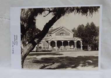
Photograph, Wycheproof Court House, (estimated); mid to late 19th century
... of Deposit' for paper based products, maps, documents and photographs.... It is now a 'Place of Deposit' for paper based products, maps ...The Court House opened as a court of petty sessions in 1890 and closed as a court in the early 1980s. It is now a 'Place of Deposit' for paper based products, maps, documents and photographs, and the home of the Wycheproof and District Historical Society Inc. The local Craft Group met at the Court House between 1982 and 2010. The Buloke Shire Council oversees the maintenance of the building.The Court House is No H 1656 on the Victorian Heritage Register. It is the one of only two buildings with this listing in Wycheproof, and characteristic of the type of building constructed in the early days of settlement in Wycheproof. The architecture is of aesthetic value and although some restoration work has taken place to maintain the structure, it remains in good condition and with some of the original furnishings intact.Sepia print of the Wycheproof-Court-House. It was constructed during 1889/90 and commissioned on September 23,1890 as a court-of-petty-sessions. A simple form of Court House built of red-face-brick but embellished by stepped brick work in the principal gable and by the traverse veranda with elaborate frieze and gabled pavilions that protect the street facade. The roof is of slate.Nonecourt house, wycheproof heritage 1890, petty sessions, building, red face brick, gabled pavilions -
 Bacchus Marsh & District Historical Society
Map, Plan of Survey of Part of Crown Allotment 9, Parish of Korkuperrimul, 1890
... This map documents a transfer of an allotment of land...This map documents a transfer of an allotment of land ...This map documents a transfer of an allotment of land in Clarke Street Bacchus Marsh in 1890. Clarke Street is located on the eastern side of Bacchus Marsh not far from Main Street and Crook Street. It is now known as Candeloro Street. The map indicates J. Booth as the owner of the land and H. Simpson as the occupier. Next to this allotment is a an allotment of land owned by J. Elmore,Single page map showing Crown allotment 9, Parish of Korkuperrimul, County of Bourke. Scale 100 feet to inch. Part of a set of maps which are pasted into a bound volume containing 76 maps or plans in total. High resolution digital image stored on BMDHS computer network. At bottom of map: I hereby certify that I have made this survey expressly for the purpose of an application under the Transfer of Land Statute that this plan is correct. Barry B???, Lic. Surveyor, 16.10.90bacchus marsh victoria maps, clarke street bacchus marsh maps -
 Bendigo Historical Society Inc.
Document - MCCOLL, RANKIN AND STANISTREET COLLECTION: NAPOLEON REEF GOLD MINING CO. N.L, 18 Feb 1941
... Document: 4 Page legal document with map of lease area... mining gold mining Napoleon Reef Document: 4 Page legal document ...Document: 4 Page legal document with map of lease area issued to William James Moore of Bendigo, Lease No. 11064 Bendigo, Vol. 325 Fol. 35881 County of Bendigo Parish of Sandhurst, 15 year lease from 18th February 1941, in vacinity of Curnow St, Booth St, Maple St and Rowan Sts, Lease by South Napoleon to be allowed to lapse in 1942, signed by Major General Sir Winston Joseph Dugan Governor of Victoria, William James Moore & witnessed by Walsh, Wardens Clerk Bendigo.organization, business, industrial - mining, mccoll rankin & stanistreet, mining, gold mining, napoleon reef -
 Bendigo Historical Society Inc.
Document - ALBERT RICHARDSON COLLECTION: SOUTH NEW MOON MINE EAGLEHAWK
... Two-page typed document with map, detailing information... document with map, detailing information on the South New Moon Gold ...Two-page typed document with map, detailing information on the South New Moon Gold Mine on the Garden Gully line of reef. Information includes the location, depth of shaft, steel poppet legs, engine house, air compressor, battery, company ownership, battery. The shaft The 'Walker and Coy' winding engine of the later company together with poppet heads was removed later to the South Virginia company between Napier and Market Street, Eaglehawk. Gold production from both companies who owned the mine was 257,498 oz.'.bendigo, mining, south new moon gold mine -
 Bendigo Historical Society Inc.
Document - MCCOLL, RANKIN AND STANISTREET COLLECTION: HERBERT JACKSON LEED OF BENDIGO, 1 April 1941
... Document Herbert Jackson Leed document gold mining lease... document with attached map and one unattached page. Map shows area ...Document Herbert Jackson Leed document gold mining lease, Vol. 325 Fol. 35900, dated 1 April 1941. 4 page document with attached map and one unattached page. Map shows area in state Forest, Parish of Mandurang. Lease between Herbert Jackson Leed and State of Victoriaorganization, mining, gold mining lease, herbert jackson leed of bendigo, gold mining lease -
 Bendigo Historical Society Inc.
Document - MCCOLL, RANKIN AND STANISTREET COLLECTION: BENDIGO EXTENDED GOLD MINING COMPANY N/L MINING LEASE, 13 November 1956
... lease. 4 page document with attached map. Map shows area... Company gold mining lease. 4 page document with attached map. Map ...Document: Bendigo Extended Gold Mining Company gold mining lease. 4 page document with attached map. Map shows area running roughly parallel to Adam Street, Quarry Hill. Lease between Bendigo Extended Gild Mining Co. N/L and State of Victoria. No. 11328, Vol 334 Fol 047.organization, mining, gold mining lease, bendigo extended gold mining co n/l; gold mining lease -
 Bendigo Historical Society Inc.
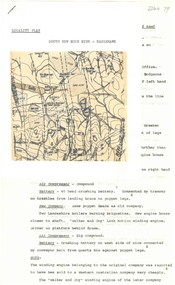
Document - ALBERT RICHARDSON COLLECTION: GARDEN GULLY UNITED MINE
... Three-page typed document plus map showing location... legs Rosalind Park Three-page typed document plus map showing ...Three-page typed document plus map showing location of the Garden Gully United Mine. The history and features of the mine operation are described and include: the locality of the shafts, winding engine, air compressor, crushing battery, engine house, gold obtained and dividends and gold production. The lookout tower in Rosalind Park was formerly the poppet legs of the Garden Gully United Gold Mining Company. Albert Richardson writes: ' a fitting tribute to Bendigo's most famous goldmine. The four-legged lookout tower was originally the six-legged poppet legs of the Garden Gully United.bendigo, mining, garden gully united mine, gold mining, poppet legs, rosalind park