Showing 198 items
matching eastern entrance
-
 Lakes Entrance Historical Society
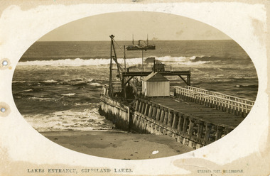
Postcard - Eastern Pier, Vogt, Stanley, 1910c
... of eastern pier at the entrance to Gippsland Lakes from ocean - Bass... early view of eastern pier at the entrance to Gippsland Lakes ...Oval shaped picture. Also other copies, oval shaped 12.5 x 17.5 cm and 17.5 x 25 cm. Also two black and white prints 9 x 13 cm.Sepia postcard in cameo image, showing early view of eastern pier at the entrance to Gippsland Lakes from ocean - Bass Strait, at Lakes Entrance, Victoria. Photo shows work shed and crane at end of wooden eastern pier, SS Wyralla at sea.Lakes Entrance, Gippsland Lakes machinery, waterways, piers, ships and shipping -
 Lakes Entrance Historical Society
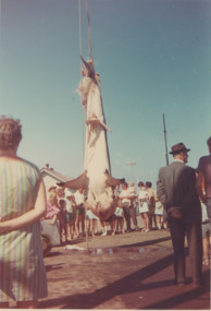
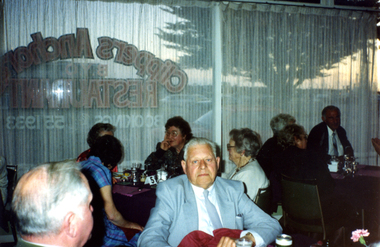
Photograph - Australian Anglers Association Carnival and Convention Lakes Entrance c1955
... viewing a large shark caught at sea and hanging on the Eastern... viewing a large shark caught at sea and hanging on the Eastern ...04308.1, 12 x 13 cmColour photograph of campers from Carpenters Camp Park viewing a large shark caught at sea and hanging on the Eastern Wharf Lakes Entrance Victoria c1965. Also a black and white photograph of the Australian Anglers Association Carnival and Convention marquee set up on Esplanade shows two memorial cypresses a number of cars parked and onlookers near marquee taken 1955 cevents, fishing, caravan parks, gippsland lakes -
 Lakes Entrance Historical Society
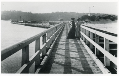
Photograph - Eastern Pier, Caire Nicholas John, 1905c
... |View of Flagstaff and Rocket Shed from the Eastern Pier... the Entrance Photograph Eastern Pier Caire Nicholas John ...2 copies with inscription below|1 x 9 x 14|1 x 12.5 x 17.5|View of Flagstaff and Rocket Shed from the Eastern Pier of Lakes Entrance, this was the New Works, (photograph 1906c - A Maclachlan)|Enlargement black and white 20.5 x 28|Also copy in Caire P01049Black and white photograph showing two ladies on Eastern Pier, view of beach, dune and flagstaff on right, entrance and northern end of pier and works buildings on left, Kalimna escarpment in background. Lakes Entrance Victoria. Plus another photo of Eastern Pier looking toward the Entrance waterways, piers, boardwalk -
 Lakes Entrance Historical Society
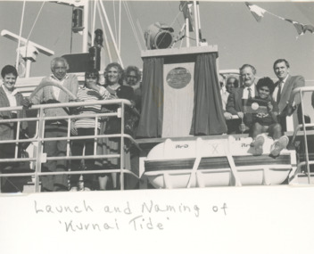
Photograph - Kurnai Tide Lakes Entrance, 1/06/1990 12:00:00 AM
... naming the Esso oil rig supply vessel Kurnai Tide at Eastern... vessel Kurnai Tide at Eastern Wharf Lakes Entrance Victoria. Also ...Black and white photograph taken at official ceremony naming the Esso oil rig supply vessel Kurnai Tide at Eastern Wharf Lakes Entrance Victoria. Also two black and white photographs taken at same event showing Albert Mullett, Jack Jacko Johnson, Corey Simpson, Mark Boon: Daryl Archibald of Esso, Shane Doyle crew member and Brian Miers Minister of Aboriginal Affairs celebrations, local government, buildings -
 Melton City Libraries
Photograph, Bruce Myers, 1931
... junction with the blind creek at the eastern entrance to Melton... junction with the blind creek at the eastern entrance to Melton ...My Story by Bruce Myers – June 2001 Arthur Bruce Myers was born on Wednesday morning on the 29/4/1925 at Kelvin Grove Hospital Bacchus Marsh. Background Information: Prepared by Niece Wendy Barrie. The early life of Bruce Myers “Burnbank” Ballarat Road Melton. The family home was built by his grandparents Ann nee Dowling and Henri Miers in 1867. His father Frederick was born in 1877 in Melton the youngest of four boys. Bruce the fourth son of Frederick and Martha, brother Frederick the eldest was followed by Marjorie and Edna. His brother Max was the youngest child. Father Frederick Myers attended Melton State School No 430 enrolling in 1881 and leaving in 1888 gaining his Merit Certificate No 116343. Bruce enrolled in July 1931 and completed and gaining his Merit Certificate in 1937. In 1938 he travelled to Melbourne Boys High School. Bruce was taught piano by his sister Marjorie, a respected Melton music teacher. He entered many Piano competitions and at the age of 10 winning the radio cup in the Junior Cavalcade at 3AW at Latrobe Street. At Melbourne Boys High School during his lunchtime was allowed to practice the piano in the basement for his recreation. He was pestered by another boy (name I have forgotten) a teacher intervened telling him to leave Myers alone. As a young child when listening to music he was able to on hearing it identify the key it was written in, due to his perfect pitch. I remember “Mum” Myers telling about the time they went to see Artur Rubeinstein at a concert, when Bruce was a small boy, it may have been on this occasion that he had noted the key of the piano composition. Bruce writes – In my early teens Max and I frequently accompanied the Williams boys, Wally and Jim on expeditions up the Toolern Creek near where the Gisborne exit now crosses it. The dogs would chase the rabbits into their burrows after placing nets over the burrows a ferret would be let in to burrow, much excitement would be involved in the rush to grab the rabbits as they bolted into the nets. In the same area I used too accompany Dad on an evening rabbit shoot (summer time). After the heat of the day the rabbits would emerge from their burrows at dusk. We would his behind the tree in silence, a mark contrast to the ferreting scene. Dad with the shotgun cocked would wait until 2 or 3 rabbits were close together then fire (Bang!). Hopefully killing two rabbits. They would have to be killed outright, otherwise they would run back into their burrows. Needless to say, one deafening shot ended the event, also it only cost one cartridge. Our only swimming pool was hole in the Toolern Creek at its junction with the blind creek at the eastern entrance to Melton. Dad swum there in the 1880’s teaching many of the youngsters to swim. Females never swum there to my knowledge. The dressing shed consisted of a 4 corrugated iron nailed to a wooden frame about 4 metres by 3 no floor or roof. We always walked the kilometre in our bathers anyway. The swimming hole once dried up leaving about 2 ft of mud. We Melton boys had so much fun fossicking around with our hands and feet and yanking out numerous eels, some very bid. I don’t know what happened to them all. No doubt Dad would have skun one or two for Mum to cook after cutting them up into short lengths. They used to jump around the pan when they were cooking. Dad accompanied by Max and I, frequently fished for eels in the Gillespie’s waterhole just below our place using a rod, line, sinker, hook baited with a worm, and a white floater so as to easily see when an eel was on the hook, so that it could quickly be pulled before it could anchor itself on and under water snag such as a tree root making it impossible to catch, or causing the line to be lost. At about the age of 8, I suddenly discovered amazingly easily means of movement. One day when I was riding the bike on rough bluestone road near the Presbyterian Church [Uniting Church] in Melton when the front fork broke and I landed on my right knee and right eye gashing both, the knee severely. I have carried the scars ever since. I started getting mobile by riding a scooter with good leg on the scooter and swinging the right leg, keeping is straight because bending it was too painful.Childhood photo of Brucelocal identities -
 Orbost & District Historical Society
black and white photograph, 1994
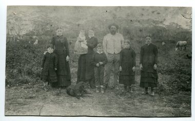
The Roadknight family settled on Ewing's Marsh on what is now known as the Old Station In 1850. The Lakes Entrance run was occupied by the late Thomas Roadknight. In 1852 his brother William took charge. Soon after this Corringle Station was occupied by the late T. T. Stirling. William was born at Collingwood, the son of William Roadknight and Jane Stirling. The Roadknight family came from Colac on board the Enterprise to their new home at Cunninghame. The house on the hill, now Pine Hill was named Merrangbaur (home of the lyrebird). William held the Lake Tyers and Snowy River run in partnership with Thomas Telfer Stirling who took up the eastern end of the run on the west bank of the Snowy River. The run included Ewing‟s Marsh — the Ewing brothers were earlier landowners but had no formal run in this area. William served four terms on the Tambo Shire Council as a representative of the Bendoc Riding despite not being a resident of the Riding. He was then elected to the Orbost Shire as a West Riding councillor in 1896-97, 1897-98 and was Shire President in his final year 1898-99 This item is associated with Roadknight family who were early settlers in the Orbost district.A black / white photograph of a family group of mother, father and six children standing outdoor. There is a dog lying in front .roadknight-william ewing's-marsh old-station-orbost -
 Eltham District Historical Society Inc
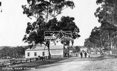
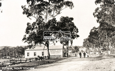
Photograph, Eltham, Main Road near station, c.1910
View looking north along Main Road, Eltham from near present day Dudley Street. On the immediate left is the railway station. The large weatherboard building on the bend (opposite present-day Arthur Street) with signs for General Store, Refreshments and Summer Drinks painted on the side is Luther and Ada Haley’s General Store and Bakery, built 1902. This was the first building in what is now Eltham’s present shopping town centre. Haley previously ran the General Store and Bakery on the corner of Main Road and York Street until his lease expired and the premises were bought by Mrs Sarah Burgoyne in 1902. The store later was known as Staff's Store. Followed by the saleyards, entrance to station, slaughter yard and William J Capewell’s butcher shop. Contained within the saleyards facing the street, a small shelter with the name H.H. Clark upon it. Horace Harold Clark was the son of Eltham State School’s first Head Teacher, David George Clark. As well as being a farmer, he was an Estate Agent and conducted auction sales, presumably from this shelter. On the eastern (right) side of Main Street is Haley’s Paddock, which was used on occasions for community picnics. Capable of holding 10,000 people, with ample shade and hilly surroundings it was an ideal place for any community gathering such as the State Schools’ Picnic in 1904. A worker from the bakery store is standing in the gateway at the rear of the store observing the photographer. People in the ‘Sunday Best’ are milling in front of the bakery or strolling down the centre of Main Road. The picture was most likely taken on a Sunday. With the opening of the railway to Eltham in 1902, Melbourne residents would regularly enjoy a Sunday excursion journey on the train to Eltham for a day’s outing to the countryside or beyond to Hurstbridge from 1912 when the railway was extended. Picture dated as c.1910 based on similar picture published in the Weekly Times, Feb. 1912. Cross Ref: 609 (looking south), 612, 611 (later stage), 613.This photo forms part of a collection of photographs gathered by the Shire of Eltham for their centenary project book,"Pioneers and Painters: 100 years of the Shire of Eltham" by Alan Marshall (1971). The collection of over 500 images is held in partnership between Eltham District Historical Society and Yarra Plenty Regional Library (Eltham Library) and is now formally known as the 'The Shire of Eltham Pioneers Photograph Collection.' It is significant in being the first community sourced collection representing the places and people of the Shire's first one hundred years.Digital image (4 x 5 inch negative missing - scanned from print) Printbaker, eltham, eltham railway station, general store, haley's paddock, luther haley, luther haley general store, main road, shire of eltham pioneers photograph collection, sign, summer drinks, butcher, railway station, w.j. capewell, eltham town centre, hot water, m.m. clark, eltham sale yards, eltham slaughter yard, staffs general store -
 Eltham District Historical Society Inc
Photograph, 23 Rockcliffe Street (Brougham Street entrance), Eltham, 3:30pm, 5 July 1967, 1967
Lot 5 L.P. 9499 at eastern most end of Brougham Street Property has since been subdivided and this access end is now 146 Brougham Street Photo taken by Russell Yeoman, Planning Department, Shire of Eltham Polaroid photographPolaroid Manufacturer Code K603831 #6brougham steet, houses, rockcliffe street, eltham -
 Eltham District Historical Society Inc
Photograph, 23 Rockcliffe Street (Brougham Street entrance), Eltham, 3:30pm, 5 July 1967, 1967
Lot 5 L.P. 9499 at eastern most end of Brougham Street Property has since been subdivided and this access end is now 146 Brougham Street Photo taken by Russell Yeoman, Planning Department, Shire of Eltham 35mm colour positive transparency blue Agfacolour Service plastic mountSlide is marked 19 July 1967 but identical to Polaroid taken by Russell Yeoman at 3:30pm on 5 July 1967 Slide also inscribed E-B and Gp PSCbrougham steet, houses, rockcliffe street, eltham -
 Marysville & District Historical Society
Photograph (Item) - Black and white photograph, Nicholas John Caire, c1880-1884
A copy of an early black and white photograph of Murchison Street in Marysville in Victoria taken by Nicholas John Caire.A copy of an early black and white photograph of Murchison Street in Marysville in Victoria taken by Nicholas John Caire. Murchison Street was named for Roderick Impey Murchison who was one of the most distinguished geologists of the 19th century. His liberality and social position plus the pride he took in his science were of immense value in furthering the cause of learning in Britain. Nicholas John Caire was born in 1837 in Guernsey. He arrived in Adelaide about 1860 along with his parents who encouraged his early interest in photography. He opened a studio in Adelaide in 1867 after traveling extensively throughout the Gippsland taking photographs. After marrying in 1870 he moved to Talbot in Victoria until 1876 when he opened a studio in the Royal Arcade in Melbourne. After 1885 Nicholas John Caire gave up his city work and made his home in South Yarra and devoted the rest of his life to outdoor photography, specializing in the bush, the gullies, and the mountains of south-eastern Victoria. LES HARSANT/ HEALESVILLE Entrance to Marysville/ from Nicholas Caire photo - c.1880-84 See Pitkethly, N.J. Caire, Landscape Photographer Pithkethly, Rosanna, Vic. 1988; plate 17murchison street, marysville, victoria, nicholas john caire, roderick impey murchison, geology, geologist -
 Phillip Island and District Historical Society Inc.
Photograph Album, Kodak, Phillip Island Cemetery, c 1990
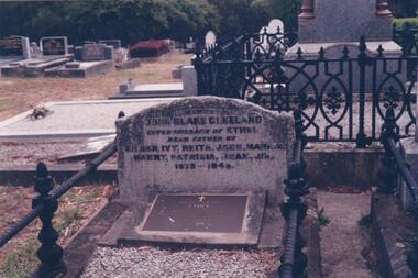
The Album was compiled by Nancy McHaffie late 1990's, with the assistance of Edith Jeffery's, with her book "Garden of Memories" and extensive knowledge of Phillip Island. The Cemetery lies back from the road and is surrounded by Manna Gums, rare Peppermint Gums, Blackwoods and other native trees. In all 25 acres of land were set aside as Crown Land in the land settlement of 1868. There are 6.2 acres of wetlands near the cemetery entrance.466-29: John Blake Cleeland lived in the house his father built, "Woolamai House" in Newhaven. His property ran cattle, horses and angora goats. He had a great love of the sea although he never went to sea. He logged all shipping movements around the Eastern passage of Westernport. He was Captain-in-charge of the Rocket Apparatus Station at Newhaven, which was a rescue service for shipping. 466-30: Eleanor Blake (nee Lucas) came out from Ireland in 1860 together with her husband Edward Hudson Blake and children. For most of her life in Australia, she resided at Hastings. Her youngest daughter Isabella married John Cleeland, both of whom are buried in the cemetery. Eleanor moved from Hastings to "Woolamai House" in later years. 466-31: Margaret Jane Cleeland (nee Kennon) married John Blake Cleeland on May 21st 1903 at South Yarra. She was the daughter of Stanley Stowell Kennon, a farmer and her mother was Isabella (nee Turner). Margaret died in 1909 at the age of 30 years. At the time of her death she was survived by three children: Eileen Henrietta, Ivy Florence & Reita Vermont.phillip island cemetery, nancy mchaffie, edith jeffery, cleeland -
 Phillip Island and District Historical Society Inc.
Photograph
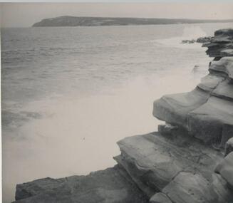
One of a collection of over 400 photographs in an album commenced in 1960 and presented to the Phillip Island & Westernport Historical Society by the Shire of Phillip IslandDr A. B. Edwards photograph of the eastern passage taken from a rock platform near San Remo and showing Cape Woolamai in the back ground.local history, photography, eastern passage, black & white photograph, coastline, cape woolamai, southern entrance to westernport, dr a b edwards, john jenner, bryant west -
 Halls Gap & Grampians Historical Society
Map - Coloured
Background on Bridle Path up Stony Creek Gorge Pre 1840 C. B. Hall, squatter on Mokepilly Run 1841-1842, first European to discover the Fyans Creek valley, the entrance of which became known as Hall's Gap. He later recorded that he followed a number of tracks which he assumed had been made by the Aboriginies and described one as "leading up a wild romantic glen and over on to the source of the Glenelg River". This could well have been the route taken up Stony Creek gorge by the first timber-cutters in this part of the Grampians to the saddle between the Wonderland and Mt. Difficult ranges known as Valley Gap 1850s/60s Timber cutters and shingle splitters were reported to be moving into the eastern side of the Grampians and by the mid 1860s there were a number of families connected to the supplying of timber to Pleasant Creek living in the "Hall's Gap ranges". John Wakeham, the first store owner in Pleasant Creek in 1854, established a timer-mill in upper Stony Creek Gorge in the late 1850s. Wakeham is credited for the clearing and levelling of the first bridle-path up the gorge. 1870s By the mid 1870s the track had been extended over Valley Gap to the Victoria Forest (the upper region of the Victoria Valley). McKeon's bullock team was known to have hauled red gum from the Valley to Stawell in the late 1870s and the 1880s. 1880s In 1887 an article in the Pleasant Creek news describes the Stony Creek Gorge track as "being a ledge alongside the mountain range, formed in the early days with the aid of earth and timber, along which the bullock teams used to travel to Horsham and plains of the Wimmera beyond." 1890s Gold was discovered in the catchment area of Stony Creek and by the end of the 1890s a new track was built from "near the junction of Fyan's and Stony Creeks, up the gorge to the diggings settlement. The mining Department had paid L300 for its construction and, when completed, the track was "three miles and 30 chains in length, the side cuttings at the narrowest part being 10 feet between" and "the watercourses which cross the track at various points" having been "filled up with rocks rolled down the sides of the hills, and consequently there can be no damage caused by bushfires which destroyed the former wooden bridges erected on the old track to Wakeham's saw-mill, the remains of which are still to be seen at the side of the diggings" The article goes on to further describe the track as one which "can with ease travel with a two horse conveyance either up or down" and that the workmen engaged in the construction of the track would be attending "a ball that night at McKeon's farm near the mouth of the gap to celebrate the successful completion of the undertaking". 1900s At what time the bridle path was extended beyond Valley Gap to the Wartook basin on the Mt. Difficult Range has not yet been determined. However, it is known that, by the turn of the century, people were travelling between Halls Gap and the caretakers' residence at Wartook Reservoir along what was now known as the "Bluff Road. Wartook's embankment had been constructed in 1887 and at that time there was already a track from Rosebrook Station homestead (near the present day Wartook Pottery) to the reservoir. Philip Rose owned both Rosebrook and Wartook Stations from the mid 1840s to the late 1850s and had regularly leased the Wartook basin to Cobb & Co. to rest horses there. 1920s Following the war of 1914-1918, tourism really took off in the Grampians, and Halls Gap rapidly grew. People would travel as far as they could on the many tracks then hike to the many lookouts being discovered by local tour guides. This led to the need for access across the range so that horse riders and the increasing number of vehicles could travel between Horsham and Halls Gap. To this end, the Bluff Road was improved and extended on 1929 and at its opening in March, 1930, by Lady Somers it was renamed the Mt. Victory Road.Map of Mt Victory Road and othersaccess routes, mt victory rd, bridle path, roads -
 Eltham District Historical Society Inc
Negative - Photograph, Eltham, Main Road near station, c.1910
View looking north along Main Road, Eltham from near present day Dudley Street. On the immediate left is the railway station. The large weatherboard building on the bend (opposite present-day Arthur Street) with signs for General Store, Refreshments and Summer Drinks painted on the side is Luther and Ada Haley’s General Store and Bakery, built 1902. This was the first building in what is now Eltham’s present shopping town centre. Haley previously ran the General Store and Bakery on the corner of Main Road and York Street until his lease expired and the premises were bought by Mrs Sarah Burgoyne in 1902. The store later was known as Staff's Store. Followed by the saleyards, entrance to station, slaughter yard and William J Capewell’s butcher shop. Contained within the saleyards facing the street, a small shelter with the name H.H. Clark upon it. Horace Harold Clark was the son of Eltham State School’s first Head Teacher, David George Clark. As well as being a farmer, he was an Estate Agent and conducted auction sales, presumably from this shelter. On the eastern (right) side of Main Street is Haley’s Paddock, which was used on occasions for community picnics. Capable of holding 10,000 people, with ample shade and hilly surroundings it was an ideal place for any community gathering such as the State Schools’ Picnic in 1904. A worker from the bakery store is standing in the gateway at the rear of the store observing the photographer. People in the ‘Sunday Best’ are milling in front of the bakery or strolling down the centre of Main Road. The picture was most likely taken on a Sunday. With the opening of the railway to Eltham in 1902, Melbourne residents would regularly enjoy a Sunday excursion journey on the train to Eltham for a day’s outing to the countryside or beyond to Hurstbridge from 1912 when the railway was extended. Picture dated as c.1910 based on similar picture published in the Weekly Times, Feb. 1912. Cross Ref: 609 (looking south), 612, 611 (later stage), 613.Negative black and white film 120 6x9 format 2 stripsAgfa APX 100baker, butcher, eltham, eltham railway station, eltham sale yards, eltham slaughter yard, eltham town centre, general store, haley's paddock, hot water, luther haley, luther haley general store, m.m. clark, main road, railway station, shire of eltham pioneers photograph collection, shops, sign, staffs general store, summer drinks, w.j. capewell -
 Federation University Historical Collection
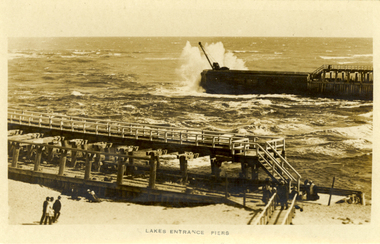
Photograph - Photograph - Black and White, Lakes Entrance Piers, c1910
Lakes Entrance is a tourist resort and fishing port in eastern Victoria, Australia.Black and white photographic postcard showing a wave breaking over a large vessel, with the timber lakes entrance Pier in the foreground. chatham-holmes family collection, lakes entrance -
 Bendigo Historical Society Inc.
Photograph - ESTELLE HEWSTON COLLECTION: FAÇADE OF EASTERN BENDIGO RAILWAY STATION BUILDING, FEBRUARY 1990, february 1990
... plarform building 15B entrance to the eastern railway station... railway plarform building 15B entrance to the eastern railway ...two colour facades of the eastern Bendigo Railway Station building. dated February 1990 15A façade of the eastern railway plarform building 15B entrance to the eastern railway station buildingEstelle Hewston -
 Hume City Civic Collection
Photograph, mid 1980s
The building in the photograph was the main administrative building of the former Sunbury Asylum which was closed down in 1991. The buildings are now part of the Sunbury campus of the Victoria University of Technology.A coloured photograph taken from the eastern side of the curved approach to the main entrance of the former Sunbury Asylum. The photograph shows the two front wings and attic of the main administrative building and other buildings beyond the main building.sunbury asylum, victoria university of technology, george evans collection -
 Whitehorse Historical Society Inc.
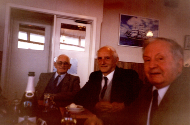
Photograph, Harold Bakes at Eastern Regions' Weekend at Lakes Entrance, 1/11/1990 12:00:00 AM
... Bakes at Eastern Regions' Weekend at Lakes Entrance. Harold ...Coloured photo of Harold Bakes at Eastern Regions' Weekend at Lakes Entrance.bakes, harold arthur -
 Whitehorse Historical Society Inc.
Photograph, Group at Eastern Region's Weekend at Lakes Entrance, 1/11/1990 12:00:00 AM
... Weekend at Lakes Entrance. Group at Eastern Region's Weekend ...Coloured photo of Group at Eastern Region's Weekend at Lakes Entrance.trevaskis, archie, gray, bill, eastern region historical societies -
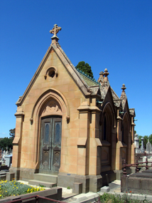
 Ballarat Heritage Services
Photograph - Digital photographs, L.J. Gervasoni, Boroondara General Cemetery Gatehouse, c2005-2015
... gates moved to the eastern entrance of the Mausoleum. Some ...The Boroondara General Cemetery is registerd by Heritage VictoriaBoroondara Cemetery in kew was established in 1858. It has an unusual triangular reserve bounded by High Street, Park Hill Road and Victoria Park, Kew. The caretaker's lodge and administrative office (1860 designed by Charles Vickers, additions, 1866-1899 by Albert Purchas) form a picturesque two-storey brick structure with a slate roof and clock tower. A rotunda or shelter (1890, Albert Purchas) is located in the centre of the cemetery: this has an octagonal hipped roof with fish scale slates and a decorative brick base with a tessellated floor and timber seating. The cemetery is surrounded by a 2.7 metre high ornamental red brick wall (1895-96, Albert Purchas) with some sections of vertical iron palisades between brick pillars. Albert Purchas was a prominent Melbourne architect who was the Secretary of the Melbourne General Cemetery from 1852 to 1907 and Chairman of the Boroondara Cemetery Board of Trustees from 1867 to 1909. He made a significant contribution to the design of the Boroondara Cemetery Boroondara Cemetery is an outstanding example of the Victorian Garden Cemetery movement in Victoria, retaining key elements of the style, despite overdevelopment which has obscured some of the paths and driveways. Elements of the style represented at Boroondara include an ornamental boundary fence, a system of curving paths which are kerbed and follow the site's natural contours, defined views, recreational facilities such as the rotunda, a landscaped park like setting, sectarian divisions for burials, impressive monuments, wrought and cast iron grave surrounds and exotic symbolic plantings. In the 1850s cemeteries were located on the periphery of populated areas because of concerns about diseases like cholera. They were designed to be attractive places for mourners and visitors to walk and contemplate. Typically cemeteries were arranged to keep religions separated and this tended to maintain links to places of origin, reflecting a migrant society. Other developments included cast iron entrance gates, built in 1889 to a design by Albert Purchas; a cemetery shelter or rotunda, built in 1890, which is a replica of one constructed in the Melbourne General Cemetery in the same year; an ornamental brick fence erected in 1896-99(?); the construction and operation of a terminus for a horse tram at the cemetery gates during 1887-1915; and the Springthorpe Memorial built between 1897 and 1907. A brick cremation wall and a memorial rose garden were constructed near the entrance in the mid- twentieth century(c.1955-57) and a mausoleum completed in 2001.The maintenance shed/depot close to High Street was constructed in 1987. The original entrance was altered in 2000 and the original cast iron gates moved to the eastern entrance of the Mausoleum. Some notable memorials include The Springthorpe Memorial (VHR 522), The Syme Memorial (1908), The Cussen Memorial (VHR 2036). Burials within the cemetery include the Henty family, artists Louis Buvelot and Charles Nuttall, businessmen John Halfey and publisher David Syme, artist and diarist Georgiana McCrae, actress Nellie Stewart and architect and designer of the Boroondara and Melbourne General Cemeteries, Albert Purchas. The Boroondara Cemetery features many plants, mostly conifers and shrubs of funerary symbolism, which line the boundaries, road and pathways, and frame the cemetery monuments or are planted on graves. The major plantings include an impressive row of Bhutan Cypress (Cupressus torulosa), interplanted with Sweet Pittosporum (Pittosporum undulatum), and a few Pittosporum crassifolium, along the High Street and Parkhill Street, where the planting is dominated by Sweet Pittosporum. Planting within the cemetery includes rows and specimen trees of Bhutan Cypress and Italian Cypress (Cupressus sempervirens), including a row with alternate plantings of both species. The planting includes an unusual "squat" form of an Italian Cypress. More of these trees probably lined the cemetery roads and paths. Also dominating the cemetery landscape near the Rotunda is a stand of 3 Canary Island Pines (Pinus canariensis), a Bunya Bunya Pine (Araucaria bidwillii) and a Weeping Elm (Ulmus glabra 'Camperdownii'). Amongst the planting are the following notable conifers: a towering Bunya Bunya Pine (Araucaria bidwillii), a Coast Redwood (Sequoia sempervirens), a rare Golden Funeral Cypress (Chamaecyparis funebris 'Aurea'), two large Funeral Cypress (Chamaecyparis funebris), and the only known Queensland Kauri (Agathis robusta) in a cemetery in Victoria. The Cemetery records, including historical plans of the cemetery from 1859, are held by the administration and their retention enhances the historical significance of the Cemetery. Digital images of a red brick gatehouse at Boroondara General Cemetery in Kew.cemetery, boroondara, kew, gatehouse, clock, tower, clocktower, heritage, memorial -
 Ballarat Heritage Services
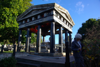
Photograph - Digital photographs, L.J. Gervasoni, Boroondara General Cemetery Springthorpe Memorial, c2005-2015
... gates moved to the eastern entrance of the Mausoleum ...The Boroondara General Cemetery is registerd by Heritage VictoriaFrom Heritage Victoria Statement of Significance Last updated on - December 15, 2005 What is significant? Boroondara Cemetery, established in 1858, is within an unusual triangular reserve bounded by High Street, Park Hill Road and Victoria Park, Kew. The caretaker's lodge and administrative office (1860 designed by Charles Vickers, additions, 1866-1899 by Albert Purchas) form a picturesque two-storey brick structure with a slate roof and clock tower. A rotunda or shelter (1890, Albert Purchas) is located in the centre of the cemetery: this has an octagonal hipped roof with fish scale slates and a decorative brick base with a tessellated floor and timber seating. The cemetery is surrounded by a 2.7 metre high ornamental red brick wall (1895-96, Albert Purchas) with some sections of vertical iron palisades between brick pillars. Albert Purchas was a prominent Melbourne architect who was the Secretary of the Melbourne General Cemetery from 1852 to 1907 and Chairman of the Boroondara Cemetery Board of Trustees from 1867 to 1909. He made a significant contribution to the design of the Boroondara Cemetery Boroondara Cemetery is an outstanding example of the Victorian Garden Cemetery movement in Victoria, retaining key elements of the style, despite overdevelopment which has obscured some of the paths and driveways. Elements of the style represented at Boroondara include an ornamental boundary fence, a system of curving paths which are kerbed and follow the site's natural contours, defined views, recreational facilities such as the rotunda, a landscaped park like setting, sectarian divisions for burials, impressive monuments, wrought and cast iron grave surrounds and exotic symbolic plantings. In the 1850s cemeteries were located on the periphery of populated areas because of concerns about diseases like cholera. They were designed to be attractive places for mourners and visitors to walk and contemplate. Typically cemeteries were arranged to keep religions separated and this tended to maintain links to places of origin, reflecting a migrant society. Other developments included cast iron entrance gates, built in 1889 to a design by Albert Purchas; a cemetery shelter or rotunda, built in 1890, which is a replica of one constructed in the Melbourne General Cemetery in the same year; an ornamental brick fence erected in 1896-99(?); the construction and operation of a terminus for a horse tram at the cemetery gates during 1887-1915; and the Springthorpe Memorial built between 1897 and 1907. A brick cremation wall and a memorial rose garden were constructed near the entrance in the mid- twentieth century(c.1955-57) and a mausoleum completed in 2001.The maintenance shed/depot close to High Street was constructed in 1987. The original entrance was altered in 2000 and the original cast iron gates moved to the eastern entrance of the Mausoleum. The Springthorpe Memorial (VHR 522) set at the entrance to the burial ground commemorates Annie Springthorpe, and was erected between 1897 and 1907 by her husband Dr John Springthorpe. It was the work of the sculptor Bertram Mackennal, architect Harold Desbrowe Annear, landscape designer and Director of the Melbourne Bortanic Gardens, W.R. Guilfoyle, with considerable input from Dr Springthorpe The memorial is in the form of a small temple in a primitive Doric style. It was designed by Harold Desbrowe Annear and includes Bertram Mackennal sculptures in Carrara marble. Twelve columns of deep green granite from Scotland support a Harcourt granite superstructure. The roof by Brooks Robinson is a coloured glass dome, which sits within the rectangular form and behind the pediments. The sculptural group raised on a dais, consists of the deceased woman lying on a sarcophagus with an attending angel and mourner. The figure of Grief crouches at the foot of the bier and an angel places a wreath over Annie's head, symbolising the triumph of immortal life over death. The body of the deceased was placed in a vault below. The bronze work is by Marriots of Melbourne. Professor Tucker of the University of Melbourne composed appropriate inscriptions in English and archaic Greek lettering.. The floor is a geometric mosaic and the glass dome roof is of Tiffany style lead lighting in hues of reds and pinks in a radiating pattern. The memorial originally stood in a landscape triangular garden of about one acre near the entrance to the cemetery. However, after Dr Springthorpe's death in 1933 it was found that transactions for the land had not been fully completed so most of it was regained by the cemetery. A sundial and seat remain. The building is almost completely intact. The only alteration has been the removal of a glass canopy over the statuary and missing chains between posts. The Argus (26 March 1933) considered the memorial to be the most beautiful work of its kind in Australia. No comparable buildings are known. The Syme Memorial (1908) is a memorial to David Syme, political economist and publisher of the Melbourne Age newspaper. The Egyptian memorial designed by architect Arthur Peck is one of the most finely designed and executed pieces of monumental design in Melbourne. It has a temple like form with each column having a different capital detail. These support a cornice that curves both inwards and outwards. The tomb also has balustradings set between granite piers which create porch spaces leading to the entrance ways. Two variegated Port Jackson Figs are planted at either end. The Cussen Memorial (VHR 2036) was constructed in 1912-13 by Sir Leo Cussen in memory of his young son Hubert. Sir Leo Finn Bernard Cussen (1859-1933), judge and member of the Victorian Supreme Court in 1906. was buried here. The family memorial is one of the larger and more impressive memorials in the cemetery and is an interesting example of the 1930s Gothic Revival style architecture. It takes the form of a small chapel with carvings, diamond shaped roof tiles and decorated ridge embellishing the exterior. By the 1890s, the Boroondara Cemetery was a popular destination for visitors and locals admiring the beauty of the grounds and the splendid monuments. The edge of suburban settlement had reached the cemetery in the previous decade. Its Victorian garden design with sweeping curved drives, hill top views and high maintenance made it attractive. In its Victorian Garden Cemetery design, Boroondara was following an international trend. The picturesque Romanticism of the Pere la Chaise garden cemetery established in Paris in 1804 provided a prototype for great metropolitan cemeteries such as Kensal Green (1883) and Highgate (1839) in London and the Glasgow Necropolis (1831). Boroondara Cemetery was important in establishing this trend in Australia. The cemetery's beauty peaked with the progressive completion of the spectacular Springthorpe Memorial between 1899 and 1907. From about the turn of the century, the trustees encroached on the original design, having repeatedly failed in attempts to gain more land. The wide plantations around road boundaries, grassy verges around clusters of graves in each denomination, and most of the landscaped surround to the Springthorpe memorial are now gone. Some of the original road and path space were resumed for burial purposes. The post war period saw an increased use of the Cemetery by newer migrant groups. The mid- to late- twentieth century monuments were often placed on the grassed edges of the various sections and encroached on the roadways as the cemetery had reached the potential foreseen by its design. These were well tended in comparison with Victorian monuments which have generally been left to fall into a state of neglect. The Boroondara Cemetery features many plants, mostly conifers and shrubs of funerary symbolism, which line the boundaries, road and pathways, and frame the cemetery monuments or are planted on graves. The major plantings include an impressive row of Bhutan Cypress (Cupressus torulosa), interplanted with Sweet Pittosporum (Pittosporum undulatum), and a few Pittosporum crassifolium, along the High Street and Parkhill Street, where the planting is dominated by Sweet Pittosporum. Planting within the cemetery includes rows and specimen trees of Bhutan Cypress and Italian Cypress (Cupressus sempervirens), including a row with alternate plantings of both species. The planting includes an unusual "squat" form of an Italian Cypress. More of these trees probably lined the cemetery roads and paths. Also dominating the cemetery landscape near the Rotunda is a stand of 3 Canary Island Pines (Pinus canariensis), a Bunya Bunya Pine (Araucaria bidwillii) and a Weeping Elm (Ulmus glabra 'Camperdownii') Amongst the planting are the following notable conifers: a towering Bunya Bunya Pine (Araucaria bidwillii), a Coast Redwood (Sequoia sempervirens), a rare Golden Funeral Cypress (Chamaecyparis funebris 'Aurea'), two large Funeral Cypress (Chamaecyparis funebris), and the only known Queensland Kauri (Agathis robusta) in a cemetery in Victoria. The Cemetery records, including historical plans of the cemetery from 1859, are held by the administration and their retention enhances the historical significance of the Cemetery. How is it significant? Boroondara Cemetery is of aesthetic, architectural, scientific (botanical) and historical significance to the State of Victoria. Why is it significant? The Boroondara Cemetery is of historical and aesthetic significance as an outstanding example of a Victorian garden cemetery. The Boroondara Cemetery is of historical significance as a record of Victorian life from the 1850s, and the early settlement of Kew. It is also significant for its ability to demonstrate, through the design and location of the cemetery, attitudes towards burial, health concerns and the importance placed on religion, at the time of its establishment. The Boroondara Cemetery is of architectural significance for the design of the gatehouse or sexton's lodge and cemetery office (built in stages from 1860 to 1899), the ornamental brick perimeter fence and elegant cemetery shelter to the design of prominent Melbourne architects, Charles Vickers (for the original 1860 cottage) and Albert Purchas, cemetery architect and secretary from 1864 to his death in 1907. The Boroondara Cemetery has considerable aesthetic significance which is principally derived from its tranquil, picturesque setting; its impressive memorials and monuments; its landmark features such as the prominent clocktower of the sexton's lodge and office, the mature exotic plantings, the decorative brick fence and the entrance gates; its defined views; and its curving paths. The Springthorpe Memorial (VHR 522), the Syme Memorial and the Cussen Memorial (VHR 2036), all contained within the Boroondara Cemetery, are of aesthetic and architectural significance for their creative and artistic achievement. The Boroondara Cemetery is of scientific (botanical) significance for its collection of rare mature exotic plantings. The Golden Funeral Cypress, (Chamaecyparis funebris 'Aurea') is the only known example in Victoria. The Boroondara Cemetery is of historical significance for the graves, monuments and epitaphs of a number of individuals whose activities have played a major part in Australia's history. They include the Henty family, artists Louis Buvelot and Charles Nuttall, businessmen John Halfey and publisher David Syme, artist and diarist Georgiana McCrae, actress Nellie Stewart and architect and designer of the Boroondara and Melbourne General Cemeteries, Albert Purchas.Digital image of the Springthorpe Memorial in the Boroondara General Cemeterycemetery, boroondara, kew, gatehouse, clock, tower, clocktower, heritage, memorial, springthorpe memorial -
 Ballarat Heritage Services
Photograph - Digital photographs, Cussen Memorial in the Boroondara General Cemetery, Kew, Victoria, c2005-2015
... gates moved to the eastern entrance of the Mausoleum ...The Boroondara General Cemetery is registerd by Heritage VictoriaFrom Heritage Victoria Statement of Significance Last updated on - December 15, 2005 What is significant? Boroondara Cemetery, established in 1858, is within an unusual triangular reserve bounded by High Street, Park Hill Road and Victoria Park, Kew. The caretaker's lodge and administrative office (1860 designed by Charles Vickers, additions, 1866-1899 by Albert Purchas) form a picturesque two-storey brick structure with a slate roof and clock tower. A rotunda or shelter (1890, Albert Purchas) is located in the centre of the cemetery: this has an octagonal hipped roof with fish scale slates and a decorative brick base with a tessellated floor and timber seating. The cemetery is surrounded by a 2.7 metre high ornamental red brick wall (1895-96, Albert Purchas) with some sections of vertical iron palisades between brick pillars. Albert Purchas was a prominent Melbourne architect who was the Secretary of the Melbourne General Cemetery from 1852 to 1907 and Chairman of the Boroondara Cemetery Board of Trustees from 1867 to 1909. He made a significant contribution to the design of the Boroondara Cemetery Boroondara Cemetery is an outstanding example of the Victorian Garden Cemetery movement in Victoria, retaining key elements of the style, despite overdevelopment which has obscured some of the paths and driveways. Elements of the style represented at Boroondara include an ornamental boundary fence, a system of curving paths which are kerbed and follow the site's natural contours, defined views, recreational facilities such as the rotunda, a landscaped park like setting, sectarian divisions for burials, impressive monuments, wrought and cast iron grave surrounds and exotic symbolic plantings. In the 1850s cemeteries were located on the periphery of populated areas because of concerns about diseases like cholera. They were designed to be attractive places for mourners and visitors to walk and contemplate. Typically cemeteries were arranged to keep religions separated and this tended to maintain links to places of origin, reflecting a migrant society. Other developments included cast iron entrance gates, built in 1889 to a design by Albert Purchas; a cemetery shelter or rotunda, built in 1890, which is a replica of one constructed in the Melbourne General Cemetery in the same year; an ornamental brick fence erected in 1896-99(?); the construction and operation of a terminus for a horse tram at the cemetery gates during 1887-1915; and the Springthorpe Memorial built between 1897 and 1907. A brick cremation wall and a memorial rose garden were constructed near the entrance in the mid- twentieth century(c.1955-57) and a mausoleum completed in 2001.The maintenance shed/depot close to High Street was constructed in 1987. The original entrance was altered in 2000 and the original cast iron gates moved to the eastern entrance of the Mausoleum. The Springthorpe Memorial (VHR 522) set at the entrance to the burial ground commemorates Annie Springthorpe, and was erected between 1897 and 1907 by her husband Dr John Springthorpe. It was the work of the sculptor Bertram Mackennal, architect Harold Desbrowe Annear, landscape designer and Director of the Melbourne Bortanic Gardens, W.R. Guilfoyle, with considerable input from Dr Springthorpe The memorial is in the form of a small temple in a primitive Doric style. It was designed by Harold Desbrowe Annear and includes Bertram Mackennal sculptures in Carrara marble. Twelve columns of deep green granite from Scotland support a Harcourt granite superstructure. The roof by Brooks Robinson is a coloured glass dome, which sits within the rectangular form and behind the pediments. The sculptural group raised on a dais, consists of the deceased woman lying on a sarcophagus with an attending angel and mourner. The figure of Grief crouches at the foot of the bier and an angel places a wreath over Annie's head, symbolising the triumph of immortal life over death. The body of the deceased was placed in a vault below. The bronze work is by Marriots of Melbourne. Professor Tucker of the University of Melbourne composed appropriate inscriptions in English and archaic Greek lettering.. The floor is a geometric mosaic and the glass dome roof is of Tiffany style lead lighting in hues of reds and pinks in a radiating pattern. The memorial originally stood in a landscape triangular garden of about one acre near the entrance to the cemetery. However, after Dr Springthorpe's death in 1933 it was found that transactions for the land had not been fully completed so most of it was regained by the cemetery. A sundial and seat remain. The building is almost completely intact. The only alteration has been the removal of a glass canopy over the statuary and missing chains between posts. The Argus (26 March 1933) considered the memorial to be the most beautiful work of its kind in Australia. No comparable buildings are known. The Syme Memorial (1908) is a memorial to David Syme, political economist and publisher of the Melbourne Age newspaper. The Egyptian memorial designed by architect Arthur Peck is one of the most finely designed and executed pieces of monumental design in Melbourne. It has a temple like form with each column having a different capital detail. These support a cornice that curves both inwards and outwards. The tomb also has balustradings set between granite piers which create porch spaces leading to the entrance ways. Two variegated Port Jackson Figs are planted at either end. The Cussen Memorial (VHR 2036) was constructed in 1912-13 by Sir Leo Cussen in memory of his young son Hubert. Sir Leo Finn Bernard Cussen (1859-1933), judge and member of the Victorian Supreme Court in 1906. was buried here. The family memorial is one of the larger and more impressive memorials in the cemetery and is an interesting example of the 1930s Gothic Revival style architecture. It takes the form of a small chapel with carvings, diamond shaped roof tiles and decorated ridge embellishing the exterior. By the 1890s, the Boroondara Cemetery was a popular destination for visitors and locals admiring the beauty of the grounds and the splendid monuments. The edge of suburban settlement had reached the cemetery in the previous decade. Its Victorian garden design with sweeping curved drives, hill top views and high maintenance made it attractive. In its Victorian Garden Cemetery design, Boroondara was following an international trend. The picturesque Romanticism of the Pere la Chaise garden cemetery established in Paris in 1804 provided a prototype for great metropolitan cemeteries such as Kensal Green (1883) and Highgate (1839) in London and the Glasgow Necropolis (1831). Boroondara Cemetery was important in establishing this trend in Australia. The cemetery's beauty peaked with the progressive completion of the spectacular Springthorpe Memorial between 1899 and 1907. From about the turn of the century, the trustees encroached on the original design, having repeatedly failed in attempts to gain more land. The wide plantations around road boundaries, grassy verges around clusters of graves in each denomination, and most of the landscaped surround to the Springthorpe memorial are now gone. Some of the original road and path space were resumed for burial purposes. The post war period saw an increased use of the Cemetery by newer migrant groups. The mid- to late- twentieth century monuments were often placed on the grassed edges of the various sections and encroached on the roadways as the cemetery had reached the potential foreseen by its design. These were well tended in comparison with Victorian monuments which have generally been left to fall into a state of neglect. The Boroondara Cemetery features many plants, mostly conifers and shrubs of funerary symbolism, which line the boundaries, road and pathways, and frame the cemetery monuments or are planted on graves. The major plantings include an impressive row of Bhutan Cypress (Cupressus torulosa), interplanted with Sweet Pittosporum (Pittosporum undulatum), and a few Pittosporum crassifolium, along the High Street and Parkhill Street, where the planting is dominated by Sweet Pittosporum. Planting within the cemetery includes rows and specimen trees of Bhutan Cypress and Italian Cypress (Cupressus sempervirens), including a row with alternate plantings of both species. The planting includes an unusual "squat" form of an Italian Cypress. More of these trees probably lined the cemetery roads and paths. Also dominating the cemetery landscape near the Rotunda is a stand of 3 Canary Island Pines (Pinus canariensis), a Bunya Bunya Pine (Araucaria bidwillii) and a Weeping Elm (Ulmus glabra 'Camperdownii') Amongst the planting are the following notable conifers: a towering Bunya Bunya Pine (Araucaria bidwillii), a Coast Redwood (Sequoia sempervirens), a rare Golden Funeral Cypress (Chamaecyparis funebris 'Aurea'), two large Funeral Cypress (Chamaecyparis funebris), and the only known Queensland Kauri (Agathis robusta) in a cemetery in Victoria. The Cemetery records, including historical plans of the cemetery from 1859, are held by the administration and their retention enhances the historical significance of the Cemetery. How is it significant? Boroondara Cemetery is of aesthetic, architectural, scientific (botanical) and historical significance to the State of Victoria. Why is it significant? The Boroondara Cemetery is of historical and aesthetic significance as an outstanding example of a Victorian garden cemetery. The Boroondara Cemetery is of historical significance as a record of Victorian life from the 1850s, and the early settlement of Kew. It is also significant for its ability to demonstrate, through the design and location of the cemetery, attitudes towards burial, health concerns and the importance placed on religion, at the time of its establishment. The Boroondara Cemetery is of architectural significance for the design of the gatehouse or sexton's lodge and cemetery office (built in stages from 1860 to 1899), the ornamental brick perimeter fence and elegant cemetery shelter to the design of prominent Melbourne architects, Charles Vickers (for the original 1860 cottage) and Albert Purchas, cemetery architect and secretary from 1864 to his death in 1907. The Boroondara Cemetery has considerable aesthetic significance which is principally derived from its tranquil, picturesque setting; its impressive memorials and monuments; its landmark features such as the prominent clocktower of the sexton's lodge and office, the mature exotic plantings, the decorative brick fence and the entrance gates; its defined views; and its curving paths. The Springthorpe Memorial (VHR 522), the Syme Memorial and the Cussen Memorial (VHR 2036), all contained within the Boroondara Cemetery, are of aesthetic and architectural significance for their creative and artistic achievement. The Boroondara Cemetery is of scientific (botanical) significance for its collection of rare mature exotic plantings. The Golden Funeral Cypress, (Chamaecyparis funebris 'Aurea') is the only known example in Victoria. The Boroondara Cemetery is of historical significance for the graves, monuments and epitaphs of a number of individuals whose activities have played a major part in Australia's history. They include the Henty family, artists Louis Buvelot and Charles Nuttall, businessmen John Halfey and publisher David Syme, artist and diarist Georgiana McCrae, actress Nellie Stewart and architect and designer of the Boroondara and Melbourne General Cemeteries, Albert Purchas.Digital imagescemetery, boroondara, kew, gatehouse, clock, tower, clocktower, heritage, memorial, cussen -
 Lakes Entrance Historical Society
Photograph, 1992
Date made December 1992Colour photograph close up view of the suction pump from the dredge Paynesville sitting on Eastern Wharf, clearly shows the name of maker Ruston Lincoln England. Lakes Entrance Victoriadredging, waterways -
 Lakes Entrance Historical Society
Photograph, 1988c
colour photo showing eastern view of Bi-Centenial clock Lakes Entrance Victoriajetties, public utilities -
![Rear [inside] view of a brass lock with key from the Port and Harbours suction dredge 'Pioneer' used at the Queenscliff creek entrance](/media/collectors/4f729f7e97f83e03086018d1/items/5f855cde425f7f235017d662/item-media/612dad24e8448ba3f69e3419/item-fit-380x285.jpg) Queenscliffe Maritime Museum
Queenscliffe Maritime MuseumFunctional object - Lock, door, brass
The Argus Melbourne Friday 10 July 1908 QUEENSCLIFF, Thursday. - After a series of successful experiments in dredging the eastern end of the South Channel, the suction dredge Pioneer sailed this after-noon for the Gippsland Lakes, where work awaits her. During operations in the South Channel the dredge worked on a sandy and shell bottom in depths ranging from 35ft. to 40ft. with unqualified success, performing the work much quicker and cheaper than the bucket drudge John Nimmo, which is still employed. Captain Macarthur was in charge of the operations.Brass lock from Port and Harbours suction dredge 'Pioneer' used at the Queenscliff creek entrance door lock, suction dredge, pioneer -
 Buninyong & District Historical Society
Photograph - Black and white photograph, Former Free Library Warrenheip Street Buninyong, 9 April 1994
Built in 1861 on land made available by Mr. Robert Allen. Grant received through municipal council and State Government. Building functioned as a library until 1926. Taken over by Buninyong Cemetery Trust and eventually fell into serious disrepair. Restored in the 1980s after great community effort, dedication and financial contributions.An important early building in the township noted for its unusual and individual classical facade of Oregon pine. Placed on Historical Buildings Register.Black and white photograph of Former Free Library built in1861. Warrenheip streetscape of former free library, currently Buninyong Information Centre, Eastern facade fully visible and Southern weatherboard side. Mature pine trees visible to the side and rear of building. Reading room on left of entrance door and former shop and residence on right.free library, information centre, mr. robert allen, buninyong cemetery trust, mechanics institutes -
 Buninyong & District Historical Society
Photograph - Original Colour Photograph, Anne Beggs-Sunter, Front door of "Mount Helen" built c. 1888, 17 May 1992
Example of late 19th Century home built by Irving and Glover for Abraham Baxter, a well known engineer, railway contractor and horse racing enthusiast. The estate consisted of about 300 acres, taking in the northern and eastern faces of Green Hill. The family lived at "Mt. Helen" until 1908. The house has been restored in recent in recent years.The fine brick house is an example of late 19th century home built and occupied by the Baxter family until 1908.Colour photograph of the front entrance to "Mount Helen" built c.1888 by Irving and Glover"Mt. Helen". built c. 1888building, green hill, irving and glover, abraham baxter -
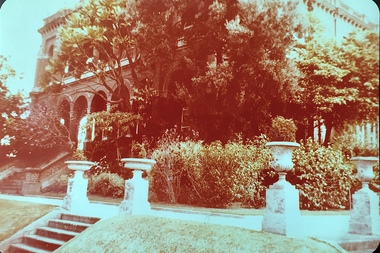 Kew Historical Society Inc
Photograph - 'Raheen', 96 Studley Park Road
Raheen was constructed as a two-storey house in the Italianate style with a four-storey tower over the entrance and single-storey extension. It was designed in an asymmetric and arcaded form, and is built of red brick with cement render. The property retains its garden layout, including an Italianate garden, outbuildings, fence and gates, and internal features including the original stairwell, library, ballroom and cast iron tower stairs. (source VHD)View of the upper and lower eastern loggias of 'Raheen' at 96 Studley Park Road, Kew from the eastern garden. The colour photo shows the pedestals and urns above the steps and the plantings in the garden c.1980. raheen -- 96 studley park road -- kew (vic.), historic houses -- studley park, mansions -- kew (vic.) -
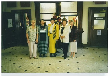 Queen Victoria Women's Centre
Photograph, December 1997
Colour Photograph. Volunteers Christmas Party. Taken in ground floor entrance foyer at the southern end of the QVWC building. Five women stand between two doors on the eastern side which lead to the cafe. These were volunteers for the Trust. Left to right: Cecelia Silverman, Maria Kremidas, Leonie Christopherson, Helen Armitage, and Sylvia Chesterman. voluntary workers, christmas -
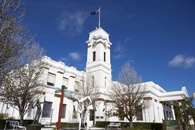 Glen Eira City Council History and Heritage Collection
Photograph - Building, Glen Eira Town Hall, 1884
Originally known as Caulfield Shire Hall, the original 1884 building was designed by Shire surveyor Sydney Smith. In 1931 the Caulfield Town Hall, as it was then known, was remodelled to include the main hall and foyer and a Neo-Grecian portico with Corinthian Order columns. Major works completed since 1945 include Caulfield Arts Complex (opened 20 August 1988), Caulfield Library (opened 4 December 1993) and the award-winning Caulfield Municipal Offices extension which opened on 24 February 1991. The building is listed as No. H0106 in the GECC Heritage Overlay Schedule. The site also includes a Significant Tree (H&H Register No. 034). Brick exterior of two storey building painted white and featuring pillared portico entrance and solid glass doors on Glen Eira road facing north. On the eastern side of the portico is a two storey clock tower with clock surmounted by a flagpole and flag. Some of the eastern section of the building is original with various alterations over the years. The award winning service centre and offices in the westerly aspect of the town hall were extended on to the original buliding in 2000.building, town hall, council, local government, caulfield, glen eira, moorabbin, sydney smith