Showing 70 items matching "energy victoria"
-
 Forests Commission Retired Personnel Association (FCRPA)
Beechworth FCV District office sign
This sign proudly hung outside the Forests Commission Victoria (FCV) Beechworth office which is now site of the Forestry Heritage Museum. The granite building in the Beechworth's historic precinct was once the Gold Warden's Office and is one of the town's original buildings. The FCV was the main government authority responsible for management and protection of State forests in Victoria between 1918 and 1983. The Commission was responsible for ″forest policy, prevention and suppression of bushfires, issuing leases and licences, planting and thinning of forests, the development of plantations, reforestation, nurseries, forestry education, the development of commercial timber harvesting and marketing of produce, building and maintaining forest roads, provision of recreation facilities, protection of water, soils and wildlife, forest research and making recommendations on the acquisition or alienation of land for forest purposes″. The Forests Commission had a long and proud history of innovation and of managing Victoria's State forests but in September 1983 lost its discrete identity when it was merged into the newly formed Victorian Department of Conservation, Forests and Lands (CFL) along with the Crown Lands and Survey Department, National Park Service, Soil Conservation Authority and Fisheries and Wildlife Service. After the amalgamation the management of State forests and the forestry profession continued but the tempo of change accelerated, with many more departmental restructures occurring over the subsequent four decades. Responsibilities are currently split between the Department of Energy, Environment and Climate Action (DEECA), Forests Fire Management Victoria (FFMV), Parks Victoria, Melbourne Water, Alpine Resorts Commission, the State Government-owned commercial entity VicForests and the privately owned Hancock Victorian Plantations (HVP).Large office sign. Hand painted in traditional FCV mission brown and gold colour scheme.forests commission victoria (fcv), forest signs -
 Melbourne Tram Museum
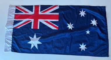
Flag - Tramway - set of 12, late 1980s
Set of 12 flags collected by the donor, unused, manufactured during the late 1980s. 1 - Australian flag - see also item 790 for a used example 2 - Support Legacy 3 - March is Red Cross calling month. 4 - 100 years of trams - see also item 2608 5 - Victoria 150 6 - Architecture Week 7 - Energy Week - May 1987 8 - Spoleto festival - blue background 9 - Spoleto festival - purple background 10 - Women 150 art festival 11 - Girl Guides 12 - ESTO '88 Melbourne - ESTO is a world-wide cultural festival for expatriate Estonians which has taken place every four years since its beginning in 1972Demonstrates the type of flags that were made for use on Melbourne trams during the late 1980s.Set of 12 flags made for use on tramcars - unused - nylon woven fabric and printed on various coloured cloths. Sewn with a loop at the left hand end to enable a wooden dowell to be fitted and secured and flown on a W class tramcar.trams, flags, melbourne, tramways, legacy, festivals, 100 years of electric trams, 150th anniversary victoria -
 Bacchus Marsh & District Historical Society
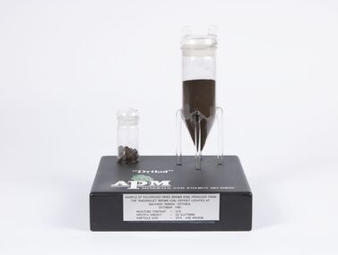
Geological specimen - Sample of Pulverised Dried Brown Coal, Maddingley Brown Coal Mine, 1981
The Maddingley area of Bacchus Marsh was surveyed for brown coal deposits in the 1930s. By the early 1940s brown coal in large quantities was being extracted and was transported to Melbourne where it was used to fire boilers for the Australian Paper Mills (APM) company. By the 1970s APM was using natural gas instead of coal. Maddingley brown coal was then used to fire boilers for the CRA/VISY cardboard factory at Bacchus Marsh. This factory closed down in 1990. During the 1990s the mine was acquired by the Calleja family company who ran transport and waste management operations.The Maddingley Brown coal mine was a major industry in Bacchus Marsh for 50 years. A sample of coal from the mine is a reminder of the importance of this local industry over an extended period of time.Two cylindrical plastic containers mounted on rectangular baseSample of pulverised brown coal produced from Maddingley brown coal deposit located at Bacchus Marsh Victoria, October 1981. Moisture content 12% - Specific energy - 22 GJ/Tonne - Particle size - 25% +90 Microncoal mines, mining, brown coal, maddingley brown coal mine -
 Bendigo Historical Society Inc.
Newspaper - Albert Ernest Richardson, Peter Anderson's article 2020
Albert Richardson was born on 22nd. June, 1902 to George Albert Richardson and Catherine Agnes (nee Flynn). He married Mavis Irene Yarwood on 23rd. December, 1931. Albert Richardson's childhood activities in Duncan Street, Long Gully, were influenced strongly by the occupation of his father and grandfather, both of whom were engine drivers on the Bendigo field. Albert had his own model goldmine, complete with poppet head, baling tanks etc and was up and ready to start work with the sound of the 7 a.m. mine whistles. Albert spent a short time working as a motor mechanic and then took up0 welling insurance with T & G. However, his heart was with the mines and he worked daytimes with T. & G. and then took off to learn engine driving with night shift in one of the mines. He gained his engine drivers' ticket in 1938 and began work at the Nell Gwynne. His longest work time was at the North Nell but he also had shorter spells at other mines. His leter work years were spent at John Brown, from where he retired in 1968. Albert had a deep regard for the working man and worked for many years in the position of Secretary at the Trades Hall, Bendigo. (adapted from biography in BHS Collection, written by I. Hendry, 1972) The Bendigo Historical Society holds a wide range of Bendigo mining records researched and written by Mr. Albert Richardson. He was President of the Bendigo Branch of the Royal Historical Society of Victoria from 1969 to 1971.When he joined the Bendigo Branch in 1966 he began compiling a history of the Bendigo mines. He spent many long hours researching at the Bendigo Mines Department, summarising mine records. He gathered relevant mining material wherever it could be obtained. He devoted most of his spare time and energy to the Society, conducting tours of the goldfields, writing articles and presenting talks to various organisations. His first and foremost interest lay in Victoria Hill. He examined mining reports and early newspaper articles to document its history. He envisaged the once fabulously rich hill as becoming a tourist attraction and campaigned vigorously to achieve this. In 1971 his dream was realised, when, with the help of South Bendigo Rotary Club 'The Hill' was cleaned up and historical site4s sign-posted. In 1972 the Bendigo Trust produced a booklet on Victoria Hill. Albert Richardson is acknowledged as the person ' on whose work and writings the text of this booklet has been based' The park adjoining Victoria Hill was named the Albert Richardson Reserve in his honour. Four newspaper clippings on mining, focusing on Albert Richardson's life; his passion for mining history and more generally, the work of engine drivers on the Bendigo goldfield. Clippings taken from the 'Bendigo Weekly' 2016, dated September 29 'Learner Drivers' , October 7 'Becoming qualified', October 14 'Steam power in his veins' and November 11 ' Victoria Hill over the decades'. All articles written by James Lerk in a series titled 'Discover Bendigo'. albert richardson, engine driver, mining, bendigo, boiler, engine room, mining cage, albert richardson reserve, victoria hill, george ellis, south bendigo rotary club -
 Bendigo Military Museum
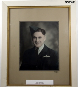
Photograph - PHOTOGRAPH, FRAMED, Vincent Kelly
IAN ALFRED (Joe) LYONS MBE Born 16.2.1915 in Bendigo enlisted in the RAAF aged 25 years on 27.5.1940, No 400095. Starting in the ranks as an LAC, he rose to Flt/Sgt pre-embarkation. He embarked for the Middle East on 2.11.1941before dis-embarking to serve with No 3 Sqd RAAF. During heavy action on 8.1.1942, his plane was forced down due to engine damage. It landed in an enemy minefield and when it came to a halt, its wheels were straddling a mine. After being rescued by a British officer, dozens of mines were located and dug up. On return, some 15 miles from base, the vehicle Lyons was travelling in hit a mine (on 9.1.1942), resulting in 5 KIA or WIA. Lyons spent 2 weeks in hospital with severe concussion and deafness. Lyons the embarked for Australia on 11.3.1942 before disembarking on 18.4.1942. He was posted to Townsville with 82nd Sqd on 27.6.1944. Subsequently he was posted to Noemfoor Island on 21.9.1944 as Operational with 82nd Sqd and promoted to Flt/Lt (Temp.) on 3.1.1945. On 6.1.1945 he was posted to 77Sqd as Operational on Morotai. This deployment ended on 9.7.1945. Records show that he flew 26 Strike/Attack missions and 13 others with both squadrons. Post WW2, Lyons remained with the RAAF with a new service number (033072). On 2.2.1948 he was posted to Japan before returning to Australia on 28.8.1948, apparently for medical reasons. He was appointed Flt/Lt on 23.9.1948 before returning to Japan and Korea on 22.8.1950. He was awarded an MBE as Operations Officer with 77Sqd for 'Outstanding enthusiasm and energy at 3 Korean bases'. A US Bronze Star was awarded to Lyons for 'Distinguished and meritorious service as Operations Officer in Korea during the period 14.10.1950 to 17.2.1951'. After Korea, Lyons received a number of posting from Victoria to Western Australia. He was awarded the Air Efficiency Medal in 1964. At his own request, Flt/Lt Ian Alfred 'Joe' Lyons MBE, retired from the RAAF HQ OP COM on 15.12.1967. The photograph is part of the Ian A. 'Joe' Lyons MBE Collection.Framed hand tinted colour head and shoulders photograph of a man in an RAAF uniform. The photograph is bordered with a light brown matt. THe wooden frome is painted white and gold. A white printed label bearing the name of the man is located below the photograph. Clear perspex covers the photograph. The photographer's name also appears below the photograph. The rear of the frame is covered in brown paper secured with masking tape. Two eyes and white cord are attached for hanging purposes.Handwritten in black below the photograph: 'VINCENT KELLY, Bendigo'.raaf uniform, photograph, flight lieutenant ian a. lyons -
Lakes Entrance Historical Society
Book, Macdonald, Jacqui, Victoria innovation events energy, 2002
... Victoria innovation events energy... of Victoria and the City of Melbourne Victoria innovation events ...A glossy 'coffee table' book, lavishly illustrated with photographs publicising the State of Victoria and the City of Melbournegovernment, tourism, education -
 Narre Warren and District Family History Group
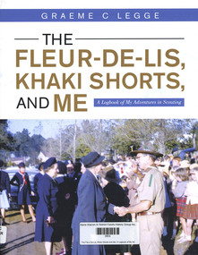
Book, Graeme C Legge, The Fleur-De-Lis, Khaki Shorts and Me: A Logbook of My Adventures in Scouting, 2022
'This Log Book is much more than its title suggests. This is the story of Scouting and of community service in and around Emerald, Victoria and ref lects the impact of Scouting in a semi-rural part of Victoria and Graeme’s role in moulding a part of it. It commences through the eyes of a youth, Graeme Legge, who joined the re-established Emerald Scout Group as a 12 year old in 1948 and recounts his leadership and support to youth and community of his town, its Scout District and Cardinia Shire over more than seven decades. Graeme shares his early Scouting travel experiences in the 1950s to Fraser Island in Queensland, to the Pieman River in western Tasmania, to Jamborees at Wonga Park, Victoria in 1948, Greystanes, Sydney in 1952 and Clifford Park, Victoria, 1956 as something we the readers can contrast with how Scouting does such adventures today.He outlines four months of overseas travel to the UK in 1951 as part of the “Sun” newspaper Youth Travel scheme where he met some fellow Scouts who, like him, were chosen to represent their local Shire and he visited places and experiences which clearly had an impact on his future Scouting journey. He captures the mood and the energy of his years of Scouting Leadership, as when he met Lady Baden-Powell in Emerald, illustrated through his photos, clippings and graphics which are drawn from his personal collection and research of local newspapers in the Victorian Scout Magazine, all befitting the method of a teaching and educational professional."--Foreword.159 p.non-fiction'This Log Book is much more than its title suggests. This is the story of Scouting and of community service in and around Emerald, Victoria and ref lects the impact of Scouting in a semi-rural part of Victoria and Graeme’s role in moulding a part of it. It commences through the eyes of a youth, Graeme Legge, who joined the re-established Emerald Scout Group as a 12 year old in 1948 and recounts his leadership and support to youth and community of his town, its Scout District and Cardinia Shire over more than seven decades. Graeme shares his early Scouting travel experiences in the 1950s to Fraser Island in Queensland, to the Pieman River in western Tasmania, to Jamborees at Wonga Park, Victoria in 1948, Greystanes, Sydney in 1952 and Clifford Park, Victoria, 1956 as something we the readers can contrast with how Scouting does such adventures today.He outlines four months of overseas travel to the UK in 1951 as part of the “Sun” newspaper Youth Travel scheme where he met some fellow Scouts who, like him, were chosen to represent their local Shire and he visited places and experiences which clearly had an impact on his future Scouting journey. He captures the mood and the energy of his years of Scouting Leadership, as when he met Lady Baden-Powell in Emerald, illustrated through his photos, clippings and graphics which are drawn from his personal collection and research of local newspapers in the Victorian Scout Magazine, all befitting the method of a teaching and educational professional."--Foreword. scouting, emerald (vic.), graeme legge -
 Lakes Entrance Historical Society
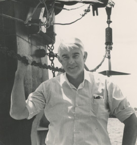
Photograph - John Kerin Minister of Primary Industry and Energy, Lakes Post Newspaper, 1/01/1990 12:00:00 AM
John Kerin Minister of Primary Industry and Energy after returning safely from a trip to sea on the Cheryl Anne and being stuck on the Bar for half an hour Lakes Entrance VictoriaBlack and white photograph of John Kerin Minister of Primary Industry and Energy after returning safely from a trip to sea on the Cheryl Anne and being stuck on the Bar for half an hour Lakes Entrance Victoriafishing industry, people, politicians -
 Lakes Entrance Historical Society
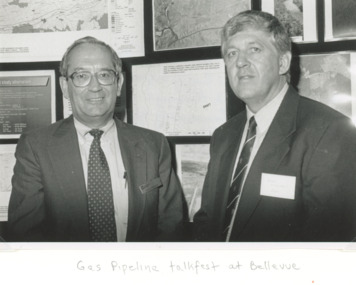
Photograph, Lakes Post Newspaper, Jack Kavannah and Barry Milliken, Lakes Entrance Victoria, 1/02/1995 12:00:00 AM
at a Gas Pipeline talk fest at Lakes EntranceBlack and white photograph of Westcoast Energy Project Manager Jack Kavannah and BHP Manager of Community Affairs Barry Milliken at pipeline Impact presentation held at Belleview Lakes Entrance Victoriaoil and gas industry, engineering, social history -
 Lakes Entrance Historical Society
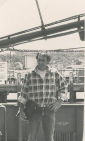
Photograph - Fishing vessel Cheryl Anne with John Kerin Minister for Primary Industry and Energy on board and getting stuck on the bar for half an hour Lakes Entrance Victoria, Lakes Post Newspaper, 1/01/1990 12:00:00 AM
John Guillot, fisherman back in port after skipping Cheryl Anne with John Kerin Minister for Primary Industry and Energy on board and getting stuck on the bar for half an hour Lakes Entrance VictoriaBlack and white photograph of John Guillot, fisherman back in port after skippering Cheryl Anne with John Kerin Minister for Primary Industry and Energy on board and getting stuck on the bar for half an hour Lakes Entrance Victoriafishing industry, boats and boating, politicians