Showing 439 items
matching flowes
-
 Nhill & District Historical Society Inc.
Clothing - c 1860 Wedding dress of Erstine Schlisweg
Erstine Schlisweg married William Bosse in Germany in 1860, later settled in Nhill districtSettlers in Nhillc 1860 Three piece silk & lace wedding ensemble handmade in Germany, consisting of a silk full length skirt with lace & ribbon trim which hugs the waist, flows into a small train at the back; the high round neck, sleeveless bodice/top tucks into the skirt, is silk with pleats down either side of a lace panel in front; cape is silk, slightly gathered so it elegantly flows over the shoulders, finishing below the hips, is trimmed with lace around the neck and bottom. Lace & ribbon trims wedding dress, william bosse, erstine schlisweg, nhill, german - textiles - handmade -
 Melbourne Tram Museum
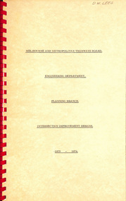
Document - Report, Melbourne & Metropolitan Tramways Board (MMTB), "Intersection Improvement designs", 1973-1974
Report - Foolscap about red comb binder with card covers, 5 pages + 3 fold out plans - titled "Intersection Improvement designs" dated 1973 - 1974. Provides designs for intersections in Flemington Road and Elizabeth St to improve flow of trams, pedestrian safety and traffic flow. Drawing P14640 - Victoria and Elizabeth Sts P14684 - Flemington Road, Royal Parade and Elizabeth St (Haymarket Roundabout) P14600 - Royal Park Junction - Abbotsford St - Flemington RoadIn top right hand corner "D W Lees" in ink.trams, tramways, trackwork, royal park, abbotsford st, flemington road, elizabeth st, victoria st, junction, road works, traffic control, haymarket -
 Moorabbin Air Museum
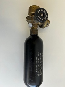
Equipment (item) - Royal Air Force (RAF) Aircrew Portable Oxygen Cylinder MK1A Ref. No. 6D/266
Case marked with Portable Oxygen Set MK1A Ref No 6D/266 AM Ref No. 6D/265 -
 Kew Historical Society Inc
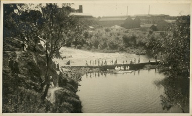
Photograph - Crossing Dights' Falls on the Yarra by foot
Dight’s Falls in Studley Park is an artificial weir built on a natural rock bar across the Yarra. The weir was built in the 1840s to provide water to the ‘Ceres’ flour-mill, one of the first in Victoria. The falls were later to become known as Dight’s Falls after the owners of the mill. Later, a pumping station was built on the Kew side of the river, which pumped water uphill to a reservoir in Walmer Street that provided water to the Melbourne Botanical Gardens and to Albert Park Lake. The area around Dight’s Falls was and is frequently used for recreational activities.Rare original print photograph of people walking across Dight's Falls when the river flow was low. View west towards Abbotsford. Photograph taken from Kew side of river above the Falls.Reverse: "M Holmes"dight's falls, river yarra -- kew - abbotsford -
 Sunbury Family History and Heritage Society Inc.
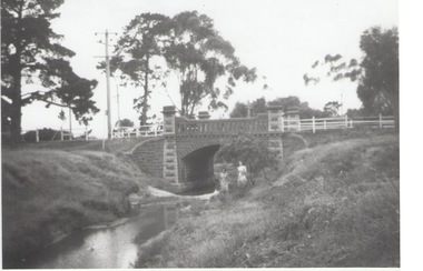
Photograph, Rosa McCall, Moonee Ponds Creek, 1949
The single arched stone bridge spans the Moonee Ponds Creek in the former Old Broadmeadows Township, now Westmeadows. The historic bridge is in Fawkner Street, and has a heritage classification. The Moonee Ponds Creek flows from the upper reaches of Greenvale and flows into the Yarra at Docklands.The stone bridge over the Moonee Ponds Creek was erected in 1869 and replaced a less substantial one.A black and white print of a non-digital photograph of a stone single-span bridge spanning a creek. White post-and-rail fence has been constructed ion either side of the bridge. Pine trees are growing on then creek banks.moonee ponds creek, old broadmeadows township, bridges, fawkner street, westmeadows -
 Ringwood and District Historical Society
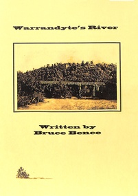
Book, Bruce Bence, Warrandyte's River, C. 1986
Historical information provided by state water, road, and metrological and local government authorities and local residents' reminicences of the Yarra River at Warrandyte. Includes table showing periodic significant flows of the river between 1863 and 1985. -
 Tatura Irrigation & Wartime Camps Museum
Photograph, Goulburn Weir, 1890
Taken by photographer for State Rivers and Water Supply Commission.Medium sized black and white photograph. Concrete and iron weir structure - granite stone spillway with minor flow of water in centre. Close up photograph sparse trees on the bank beyond. Gas lamps on walkway.goulburn weir, victorian state rivers and supply commission -
 Bendigo Historical Society Inc.
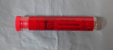
Functional object - Carter's Little Liver pills
Small plastic tube with a red label for Carter's Little Liver pills. Carter's Little Liver Pills were billed as a medicine aiding bile flow in the liver. The tube is empty. Aileen and John Ellison Collectionmedicine, pills, carter's -
 Federation University Historical Collection
Banner, Chinese Calligraphic Banner, 10/08/1995
Presented to the Ballarat School of Mines from Changzhou Educaiton Delegation. A Chinese calligraphic banne a a famous poem 'On the Stork Tower' written in the Tang Dynesty by Wang Zhihuan. The Sun along the mountains bows; The yellow river seawards flows. You will enjoy a grander sight; By climbing to a greater height. wang zhihuan, poem, tang dynasty, stork tower, changzhou, chine, calligraphy -
 Greensborough Historical Society
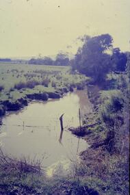
Slide - Photograph, John Ramsdale, Plenty River: Slide 19, 1990s
Photograph shows low water flow on the Plenty River near South Morang or Mernda.Part of the John Ramsdale collection of slides and audio visual material.Colour photograph scanned from slide.No maker's marks. No caption on slide.south morang, mernda, plenty river -
 Greensborough Historical Society
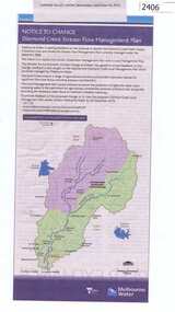
Newspaper Clipping, Diamond Creek stream flow management plan, 30/09/2015
In this Public Notice, Melbourne Water seeks feedback on the Diamond Creek Stream Flow Management Plan.News clipping, black text, colour map.diamond creek stream flow management plan, melbourne water. -
Coal Creek Community Park & Museum
Ink bottle, Simpson's Ink Pty Ltd
Square bottle of red ink with screw in cork lid and red, blue and yellow label.Simpson's Celebrated Writing Ink. This is made specially to flow freely with all standard makes of fountain pen and with steel nibs. Sole manufacturer Simpson's Ink Pty Ltd. Australia. -
 Orbost & District Historical Society
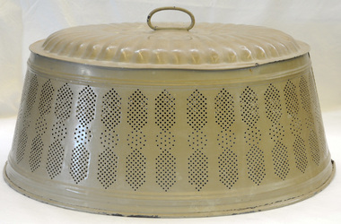
food cover, 1940's (?)
This item was owned and used by Alice Pow (nee McWilliam), known as Maccie. Maccie was a nurse who came to Orbost in 1936. She was highly respected in Orbost for her nursing skills particularly during the 1938 outbreak of polio, Most patients were cared for in their homes and Miss McWilliam was sent out to care for them. Over 14 months she travelled 9560 miles supervising their treatments. She eventually married Mr Hec Pow who had been left to bring up his three daughters after his wife died.. The Pows lived in Orbost where Hec Pow was worked with his father Fred at the saw mill in Cabbage Tree. Maccie Pow was a member of the Orbost Bowling Club, Red Cross and Orbost Golf Club.An oval shaped metal food cover made of pressed tin painted tan. It has a loop handle on the top. The sides slope outwards and it is seamed on both sides. The bottom edge is rolled. The sides have a perforated design for air flow.food food-protection kitchen-ware pow-maccie mcwilliam-alice -
 Mission to Seafarers Victoria
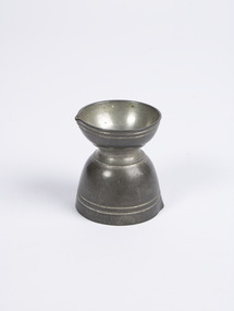
Functional object - Double-ended Pouring Cup, c. 1840
Used to measure and pour liquid medicineDouble-ended measurement or pouring cup with a notched point for easy flow for substances exiting the container. Top cup is approximately four times the volume of the bottom cup. Each cup features two engraved bands near their respective rims. volum collection, chemist, druggist, medicine -
 Anglesea and District Historical Society
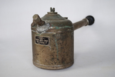
Takii's Auto-Spray, Takii & Company, Estimated post 1926
Metal canister with domed top with aperture in centre. "Butterfly" screw top in aperture. Nozzle on front of canister with "butterfly" fitment to control flow. Handle with hand-pump mechanism with wooden knob at the end. "A/R/14/6" handwritten on base.[Logo] / TAKII"S AUTO-SPRAY / TAKII & COMPANY LTD / MADE IN JAPANtakii, gardening -
 Linton and District Historical Society Inc
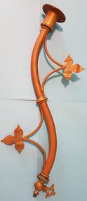
Gas light bracket, Gas Light, Presbyterian Church, Linton
Until Linton was connected to the statewide electricity grid in 1939, this gas light was used to light the altar at the Presbyterian Church in Linton.Curved gas light wall bracket, ornamented with leaves. One end designed to be attached to a wall, the other end has a valve, presumably to control the flow of gas. Beyond this valve, the end of the fitting is threaded, to facilitate attachment of a glass cover.gas lighting, presbyterian church linton -
Coal Creek Community Park & Museum
Ink bottle, Simpson's Ink Pty Ltd
Square shaped glass bottle with brown plastic lid and blue, red and white label.Simpson's Celebrated Green Writing Ink. This is made specially to flow freely with all standard makes of fountain pen and with steel nibs. Sole manufacturer Simpson's Ink Pty Ltd. Australia. -
Coal Creek Community Park & Museum
Ink bottle, Simpson's Ink Pty Ltd
Square glass bottle containing ink with an aluminium screw top.Simpson's Celebrated Violet Writing Ink. This is made specially to flow freely with all standard makes of fountain pen and with steel nibs. Sole manufacturer Simpson's Ink Pty Ltd. Australia. -
 Hymettus Cottage & Garden Ballarat
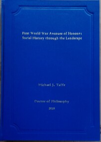
Book - Thesis, First World War Avenues of Honour: Social History Through the Landscape'
non-fictionthesis, great war, ballarat, avenue of honour, michael taffe, war memorials, memory, landscape -
 Bendigo Historical Society Inc.
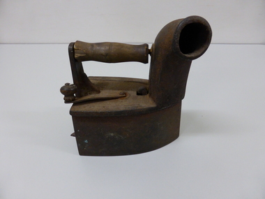
Domestic Object - BOX/COAL IRON
Cast iron coal iron or Box iron with wooden handles, hinged top lifts for inserting hot coals inside and a chimney in front allows smoke to escape, a small hole on rear with door allows for air flow. Estate of E. Shermandomestic equipment, laundering, iron, estate of e. sherman -
 Hume City Civic Collection
Photograph, early 1980s
The photograph shows the extent of Sunbury's development to the west of the town in the early 1980s. The settlement at this stage extended along either side of Gap Road for about 0.5 km beyond Elizabeth Drive.A coloured landscape photograph with rounded corners taken from Mt. Holden and looking towards the expanding town of Sunbury. The Melba Avenue drain which flows into Blind Creek is in the foreground. Sheoak Hill, the site of the former Sunbury Asylum is in the middle of the skyline.sunbury township, reservoir road, mt. holden, sunbury asylum, george evans collection -
 City of Ballarat
Artwork, other - Public Artwork, Aaron Robinson et al, Flow by Holly Grace and Aaron Robinson, 2014
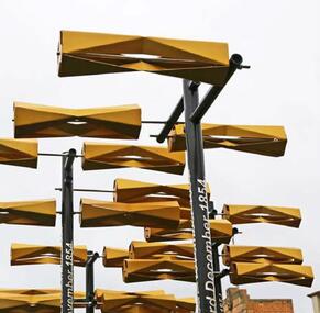
Water is key to a thriving community and it is through the representation of water Flow enlivens the space at Bakery Hill. Historically ‘water races’ ran through the valleys of the Greater Ballarat area unearthing the minerals that forged prosperity and wealth. This water still flows today unearthing new possibilities for the community. Possibilities focusing on sustainability, ecology, health and prosperity. Flowing over the site a series of kinetic turbines flutter in the wind creating a contemporary water race. The interactive elements offer visual stimulation enticing people to connect with the artwork and in turn the surrounding spaces. Bakery Hill has great historical significance. It’s connection to the Eureka Stockade and the series of events that were to unfold during the 1850’s was to become the turning point in Australian political history. The placement of each turbine is to mirror a point of history in the timeline of events that occurred during the Eureka Stockade. The Water Race is a symbol of possibilities, the ones created by history and those of modern society. It is a visual timeline that can be read by traversing the site. The connecting turbines that flow and turn in sync are a representation of time passing and the interconnectedness of history with the community that surrounds it. The gateway to Bridge Mall is framed through the placement of each turbine allowing the sense of prosperity and wealth to flow through to the surrounding community. This gateway also references the significance of Bakery Hill reinvigorating the historical site by reconnecting it back to its town centre. The artwork is of aesthetic and historical significance to the people of BallaratTwelve steel turbines set on poles with dates attached and a large bronze 'timeline' plaqueFLOW/ Plotting the motion of Wind, Water, History and Time/ by Holly Grace and Aaron Robinson/ This site has great historical significance. It’s connection to the Eureka Stockade and the series of events that unfolded in the 1850’s was to become the turning point in Australian history. The placement of each turbine within this artwork mirrors a point of history in the events that led up to the Eureka Stockade. It is a visual timeline that can be read by traversing the site. The connecting turbines that flow and turn in sync are a representation of time passing. They are a symbol of the community’s connection to their history. 1851 June James Esmond makes the first discovery of gold in Victoria at Clunes./ 1st July The Port Phillip District separates from New South Wales and becomes the Colony of Victoria. It is still subject to British rule./ August Gold is discovered at Buninyong and at Golden Point, Ballarat. Lt-Governor La Trobe introduces the Gold Licence system in an attempt to reduce the colony’s debt./ 20th September First gold licences issued in Ballarat. / 1852 August/ Eureka Lead discovered on the Ballarat goldfields. December Charles La Trobe resigns as Lt-Governor but he is not relieved until 1854/ July – December/ Unrest builds on the various goldfields with protest meetings held in Bendigo and Castlemaine. Bendigo’s Red Ribbon Movement is active on the goldfields and the Bendigo Petition is presented to Lt-Governor./ December/ Charles Hotham is appointed Lt-Governor/ 1854 March/ A bill to extend the Elective Franchise is passed by the Legislative Council and sent to London for the assent of the British Parliament. 22nd June/ Lt-Governor Sir Charles Hotham arrives in Victoria. The colony faces mounting debt and Hotham orders weekly licence hunts in an attempt to increase income./ August/ Hotham is acclaimed during his visit to the Ballarat goldfield./ 13th September? Hotham orders twice-weekly licence hunts to further increase revenue./ September – October/ Miners are experiencing problems – no shafts bottomed on the Eureka Lead for five weeks./ 7th October/ James Scobie is murdered outside the Eureka Hotel. Many diggers believe that publican James Bentley is responsible./ 9th October/ At Scobie’s inquest, Bentley is acquitted, despite strong evidence of his guilt./ 10th October/ Father Smythe’s servant is beaten up by authorities and falsely arrested for not holding a licence./ 15th October/ Mass meeting of miners on Bakery Hill. Catholic miners meet after Mass. // 17th October/ A meeting of up to 10,000 Diggers is held near the Eureka Hotel to protest against Bentley’s acquittal. The meeting results in the burning of the hotel. Three diggers, Westerby, Fletcher and McIntyre, are arrested. Hotham dispatches 400 soldiers to Ballarat. 22nd October/ Another large meeting is held to address grievances. The Catholics send their leaders, Hayes, Kennedy and Manning to meet Rede. The Government Camp is under siege 11th November/ A public meeting on Bakery Hill results in the formal establishment of the Ballarat Reform League and adoption of the League’s proposals./ 21st November/ The enquiry into the Bentley affair is published. It recommends the dismissal of the judge and the establishment of a Royal Commission. 23rd November/ Westerby, Fletcher and McIntyre are convicted of burning the hotel. The Ballarat Reform League demands their release. 27th November/ A deputation from The Ballarat Reform League, including Humffray, Black and Kennedy, meet with Hotham to demand the release of the three prisoners. Hotham does not believe the diggers have the right to “demand anything”, Rede requests reinforcements in Ballarat. 28th November/ Miners attack the troop reinforcements and wagons passing near the Eureka diggings. A drummer boy is seriously wounded. 29th November/ A “Monster Meeting” attended by more than 10,000 diggers is held on Bakery Hill. The Southern Cross flag is flown for the first time. Peter Lalor addresses the miners and a number of diggers burn their licences. 30th November/ A licence hunt occurs in the morning at the order of Commissioner Rede. Another meeting of radical miners is held on Bakery Hill. Peter Lalor becomes leader of the diggers and calls for volunteers. Many diggers wear an oath to defend their rights and liberties under the Southern Cross flag. A number of diggers move to the Eureka Lead and start to erect a stockade. 3rd December In the early hours of Sunday morning 296 soldiers and police led by Captain Thomas proceed from the Government Camp to the Eureka Lead and attack the Stockade. 22 diggers and 7 military are officially listed as being killed. Many others are wounded. Approximately 120 diggers are arrested and marched to the Government Camp. 4th December/ Funeral of some of the fallen diggers and soldiers. Martial Law is proclaimed in Ballarat. Henry Seekamp, editor of the Ballarat Times is charged with seditious libel. 6th December/ Major General Sir Robert Nickle, commander-in-chief of the military forces in the Australian colonies, arrives in Ballarat. 9th December/ General Nickle repeals martial law. 14th December/ The Gold Fields Commission sits for the first time. 18th December/ The first Ballarat sitting of the Gold Fields Commission is held at Bath’s Hotel. 1855 23rd January/ Henry Seekamp is found guilt of sedition and sentenced to three months in prison. 22nd February/ The Eureka trials starts in Melbourne. February to March/ 13 prisoners are tried and acquitted amid great public rejoicing. 27th March Report of the Royal Commission recommends miners’ rights and significant reforms. 10th November/ Peter Lalor and John Basson Humffray are nominated for seats in the legislative Council. 31st December Sir Charles Hotham dies before his resignation takes effect. flow, aaron robinson, holly grace, public art, eureka stockade, bakery hill -
 Wodonga & District Historical Society Inc
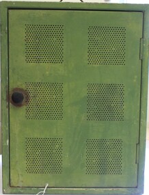
Domestic object - Meat Safe known as a "Coolgardie Safe", Early 1900s
The Coolgardie safe was invented in the late 1890s on the Western Australian goldfields. Its invention was credited to a local contractor named Arthur Patrick McCormick. It was a practical system to preserve food prior to modern refrigeration. The wire grid kept the food safe from vermin and allowed breeze to blow through. It was often covered with wet hessian so that as the breeze circulated the water evaporated, creating the same concept as coolant in modern refrigerators and ice boxes. In most respects it was a variation of the bushman’s hessian bag hanging in a tree. In larger towns and cities during this time period large "ice works" could deliver block ice to areas that required a form of refrigeration. These ice blocks where held in early refrigerators to keep perishables cool. In isolated or rural households, the Coolgardie or meat safe was the next best, practical solution for food preservation. This safe was used in the home of the Conway family in Wodonga.This item is very significant to the Wodonga region as it represents the initiative and problem solving skills of the early settlers. It also reflects the primitive conditions in which they lived before the arrival of more modern services such as electricity.Meat safe or Coolgardie safe manufactured in Australia. This safe is made from metal and has been painted in green paint. 2 sides of the safe have a pattern of 6 squares of holes to allow for ventilation and air flow. The holes would also guard against insects and other vermin. There is one shelf inside, dividing it into 2 sections. The safe has a hook attached so that it can be suspended, often from a tree or on a verandah to increase air flow. The safe would often be covered by wet hessian to promote further cooling and preservation of foods such as milk, butter and meat.coolgardie safe, food preservation, pioneers innovation -
 The Beechworth Burke Museum
Photograph, c1930
Taken on 25 October 1930, various houses with the Hume Dam under construction are depicted in the background. The construction of the Hume Dam took place from 1919 to 1936. At the time of construction, it was the second largest dam in the world. It was also one of the earliest civil projects developed after the Federation. Some of the Dam workers consisted of World War I veterans. Dam workers often settled their families in Mitta Junction Village and Wodonga. Archaeological surveys were completed by Austral Archaeology, which was done when the Department of Land & Water Conservation was doing work to improve Hume Dam. The archaeological report that came out of the survey recommended three sites of interest where archaeological excavation should be done: Camp Ganger’s Quarters, Stableman’s Quarters, and the Industrial Dump. The excavation uncovered artefacts. Mitta Mitta: Mitta Mitta is situated between Mount Welcome and Mount Misery. It is named after the river that explorers Hume and Hovell discovered in 1824. The town would eventually become a huge gold mining town. Mitta Mitta is called Midamodunga by the local Indigenous peoples Wodonga: Wodonga is situated on the Murray River and is part of North East Victoria. Hume and Hovell: Hamilton Hume (1979-1873) and William Hilton Hovell (1786-1875). W. H. Hovell was born in Norfolk England and Hume was born in Parramatta, New South Wales Hovell and Hume undertook an exploration journey in 1824 and thought they discovered a river, which turned out to be the Murray River. They returned home in 1825, but returned to the area in 1826 and discovered coal in the area.This photo is historically significant as it shows the Hume Dam under construction in 1930. The Dam was named after Hamilton Hume, who is an important historical figure for this area as he helped discover the area where resources were found.Sepia rectangular photograph printed unmountedReverse: 84-19-2/ 1997.3188/ These are the four / release valves they are / not always open (illegible) this / when closed the water flows / over the spillway. [featuring trademark: kodak print] photograph number: 354construction, houses, veterans, mitta junction village, hume dam, world war i, federation, wodonga, archaeological survey, excavation, austral archaeology, department of land & water conservation, camp ganger's quarter's, stableman's quarters, industrial dump, artefacts, mitta mitta, mount welcome, mount misery, murray river, hamilton hume, william hilton hovell, hume and hovell expedition -
 Hymettus Cottage & Garden Ballaratnon-fictionavenues of honour, war, war memorials
 -
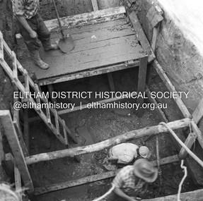 Eltham District Historical Society Inc
Negative - Photograph, J.A. McDonald, Henley Road at Watsons Creek, Apr. 1961
Henley Road at Watsons Creek showing excavation at western pier Rock at contract level, slight underground flow Early April 1961Record of various Shire of Eltham infrastructure works undertaken during the period of 1952-1962 involving bridge and road reconstruction projects, sometimes with Eltham Shire Council Project Reference numbers quoted. It was during this period that a number of significant improvements were made to roads and new bridges constructed within the shire that remain in place as of present day (2022). In many situations, the photos provide a tangible visible record of infrastructure that existed throughout the early days of the Shire. The album was put together by or under the direction of the Shire Engineer, J.A. McDonald.infrastructure, shire of eltham, bend of islands, cr. charis pelling, henley road, henley road bridge, kangaroo ground, oxley bridge, watsons creek, w.e. wolf, bridge construction, road construction, 1961-04 -
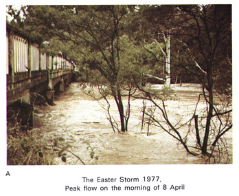 Eltham District Historical Society Inc
Work on paper (Sub-Item) - Photograph, Main Road Bridge, Eltham peak flow of flood 8 April, 1977
Colour photograph. Flooding of Diamond Creek at Main Road Bridge, Eltham peak flow of flood. Easter storm, 8 April, 1977flood, diamond creek, flooding, eltham, bridge, main road -
 Greensborough Historical Society
Domestic object - Soap holder, Soap cage, 1950c
Household item from 1950s to 1960s used to hold soap; allows water to flow through the container for creating soapsuds to wash dishes.Pink plastic soap cage, square cage with long handle.household implements, soap, soap holders, soap-savers -
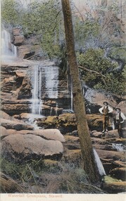 Halls Gap & Grampians Historical Society
Postcard - Coloured
This postcard was printed in Germany and hand coloured. The name of the waterfall is not givenPostcard showing two men, with hands on hips, standing beside a waterfall. The waterfall flows over two rock ledges. Both men are wearing hats. A tree stands almost centre foreground and runs to the top of the card. The postcard has been hand coloured.Waterfall Grampians, Stawell printed on the bottom of the postcard in red.scenery, waterfalls -
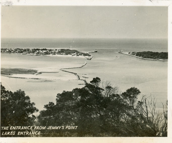 Lakes Entrance Historical Society
Postcard - The Entrance, 1940c
Originally in a pack of miniature postcards produced for sale to tourists.Black and white small format postcard of the Western end of Bullock Island, Reeves and Entrance Channels, the Entrance and Carpenter Town at the New Works. Taken from Jemmys Point, it shows rock groynes built to channel water flow to the Entrance. Lakes Entrance VictoriaThe Entrance Jemmys Point Lakes Entrance V2 topography, waterways