Showing 137 items matching "george farmers"
-
 Warrnambool and District Historical Society Inc.
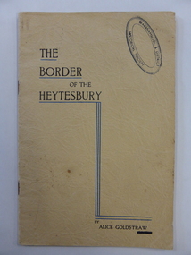
Book, The border of the Heytesbury, 1937
This book has been written by Alice Goldstraw in 1937. It is a fine history of life in the Naringal/Cudgee/Heytesbury Forest area at the end of the 19th century. There are accounts of the bushland, the school and the people in the area. Alice Goldstraw (d. 1967) was the daughter of George and Robina Goldstraw who were pioneer farmers in the Cudgee area. The Goldstraw families were prominent in the early history of Warrnambool and district, especially as timber millers and sawyers. This book is of considerable importance as it is a rare copy of ‘The Border of the Heytesbury’ written by Alice Goldstraw. It provides a wealth of material for researchers. An index to the book has been compiled by the Warrnambool and District Historical Society. This is a soft cover booklet of 34 pages. It has a buff-coloured cover with black printing and blue lines on the front cover. There is also a Warrnambool & District Historical Society stamp on the front cover. There are eleven chapters on ‘The Border of the Heytesbury’ and one chapter on ‘Some People in the Heytesbury’. The printed pages are divided into two columns. The pages have been stapled but the staples have been removed.history of cudgee/naringal/heytesbury forest area, history of warrnambool, alice goldstraw -
 Warrnambool and District Historical Society Inc.
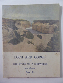
Book, Loch Ard Gorge, Early 20th century
This is a booklet containing an epic-style poem by Alice Goldstraw on the subject of the wreck of the ‘Loch Ard’. Alice Goldstraw (died 1967) was the daughter of George and Robina Goldstraw who were pioneer farmers in the Cudgee area. The Goldstraw families were prominent in the early history of Warrnambool and district, especially as timber millers. The ‘Loch Ard’ wreck (1878, Mutton Bird Island near Port Campbell) is Victoria’s most famous wreck – 51 lives lost with only two survivors. The story of the survivors, Eva Carmichael and Tom Pearce has legendary status in the stories of shipwrecks in Victoria and has been the subject of articles, songs, poems, plays, novels and films. This booklet is of great significance because it is a well-written poem by Alice Goldstraw, a member of a pioneer family in the Cudgee area. It is a notable early poem about the wreck of the ‘Loch Ard’ which has attracted much interest in the Warrnambool area and beyond. Flagstaff Hill Maritime Museum in Warrnambool specializes in promoting stories of this wreck and features many relics of the wreck in its collection – the Loch Ard Peacock, the Carmichael watch, the Tom Peace binoculars etc. The laser night show at this Museum currently features the story of the wreck. Original copies of this poem are now rare.This is a soft cover booklet of 20 pages containing a poem about the wreck of the ‘Loch Ard’. The cover is cream-coloured with the front cover having blue print and a sepia-coloured photograph of the Loch Ard Gorge. The booklet has a page of photographs connected to the ‘Loch Ard’ and an ornamental black border around each page of the stanzas. The front cover is somewhat blotched and stained. The booklet has been stapled but the staples have been removed.poetry, loch ard shipwreck, warrnambool authors, alice goldstraw, warrnambool history -
 Eltham District Historical Society Inc
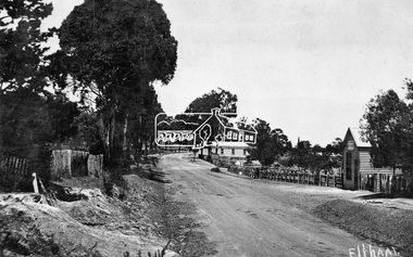
Negative - Photograph, Tom Prior, Main Road near Eltham Railway Station, c.1910
View looking south along Main Road, Eltham from near present day Luck Street. On the immediate right is a fence with the words “Hot Water” painted on it followed by William J Capewell’s butcher shop, then the slaughter yard and saleyards with the entrance access to the railway station. Contained within the saleyards facing the street, a small shelter with the name H.H. Clark upon it. Horace Harold Clark was the son of Eltham State School’s first Head Teacher, David George Clark. As well as being a farmer, he was an Estate Agent and conducted auction sales, presumably from this shelter. The large weatherboard building on the corner (opposite present-day Arthur Street) with signs for Summer Drinks and Hot Water painted on the side is Luther and Ada Haley’s General Store and Bakery, built 1902. This was the first building in what is now Eltham’s present shopping town centre. Haley previously ran the General Store and Bakery on the corner of Main Road and York Street until his lease expired and the premises were bought by Mrs Sarah Burgoyne in 1902. The store later was known as Staff's Store. In the distance approximately mid-way between the Butcher shop and the Bakery are the tops of what appears to be two cypress trees, which could well be the trees in front of the Shillinglaw Cottage facing Main Road. On the eastern (left) side of Main Street is Haley’s Paddock, which was used on occasions for community picnics. Capable of holding 10,000 people, with ample shade and hilly surroundings it was an ideal place for any community gathering such as the State Schools’ Picnic in 1904. Picture dated as c.1910 based on similar picture published in the Weekly Times, Feb. 1912. Kerb and channelling added 1923. Cross Ref: 610 (looking north), 611 (later stage), 613. Same as 705 (though in better condition)This photo forms part of a collection of photographs gathered by the Shire of Eltham for their centenary project book,"Pioneers and Painters: 100 years of the Shire of Eltham" by Alan Marshall (1971). The collection of over 500 images is held in partnership between Eltham District Historical Society and Yarra Plenty Regional Library (Eltham Library) and is now formally known as the 'The Shire of Eltham Pioneers Photograph Collection.' It is significant in being the first community sourced collection representing the places and people of the Shire's first one hundred years.Digital image 4 x 5 inch B&W Neg 120 format B&W negative (spare)shire of eltham pioneers photograph collection, eltham, main road, butcher, eltham railway station, railway station, w.j. capewell, baker, eltham town centre, general store, luther haley, reynolds prior collection, shops, haley's paddock, hot water, m.m. clark, sign, summer drinks, eltham sale yards, eltham slaughter yard, staffs general store -
 Orbost & District Historical Society
black and white photograph, 1912 - 1920
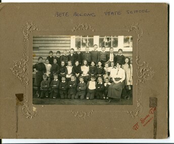
This school photograph has been identified by Mary Gilbert as being of Bete Bolong students with their teacher. The names are written on a separate piece of paper which was attached to the photograph. Back Row - George Healey; George Madden; Bert Paton; Harold Cumming; Charlie Ingram; Stan Paton; Bill Madden; Frank Sealey; Tom Cumming; Ted Johnston Middle Row - Rita Mundy; Ruby Richardson; Mary Cumming; Mollie Ingram; Clarrie Paton; Irene Richardson; Ella Paton; Ena Cumming; Grace Mundy; Violet Sealey; Maggie Webb; Bertha Johnstone Front Row - Billy Ingram; Ernie Sealey; Archie Johnston; Rupert Madden; Ron Healey; Jack Cumming; Gordon Healey; Mrs Hannak (?) Conner - teacher n 1912 the school at Pumpkin Point opened to serve the children of farmers living in the Bete Bolong district. This meant a big change in their way of life because in the past the children had been rowed across the Snowy River each day to attend school at Jarrahmond. Myrtle Bunting was the first HT of the school which had been erected on a block of land purchased from H. Richardson. The school functioned until 1952 when a shortage of pupils caused its closure. As a bus service to Orbost now operated, the school at Pumpkin Point faced permanent closure.This photograph is associated with education in Orbost. There is no longer a school at Bete Bolong.A black / white photograph of a group of school children with an adult. Behind the three rows of children is a wall and windows. The back row is standing,the middle seated and the front row kneeling. The photograph is glued onto a brown cardboard mount with embossed decoration. On the front bottom right in red lettering "W Stanley Vogt, BAIRNSDALE".BETE BOLONG STATE SCHOOL W.Stanley Vogt, BAIRNSDALEbete-bolong-state-school education-orbost -
 Orbost & District Historical Society
black and white photograph, Wilson, Les G, first half 20th century !930s-40s?
This is a photograph of students of Orbost State School. Those in the photograph have been identified by Mary Gilbert. Back Row - Billy Nixon; ?; ?; ?; Albert Williams; Stan Porter; Stan Farmer; Bert Johnston; Betty Gilbert; Bernice Feltis; Olive Gall; Lorna Farquahar: Bessie Gibbs; Cora Morgan; Dorothy Broome ?: Jack Gargan; Bill Dreverman; Tom Stevenson; George French; ?; Jim Nixon; Dorothy Tipping; Lorna Sadler; Ivy Swan; ?; ?; Edie Gall; ? ?; ?; Ray Tyrell; ?; ?; Tom Rodwell; /; Una Perry; Perth Hardy; ?; Molly Pardew; Alice Hammill; Effie Hammill; Muriel Grose; Francie Robinson; Marion Gilbert Jim Tipping; Dave Murray; Arthur Simpson; ? Grose The 19th of March 1886 proved an important day in the lives of many early settlers in the Orbost area, because on this day the Orbost State School opened. The fact that the school had first operated temporarily in a leased building, and on a half-time basis with SS2745 Jarrahmond, did not dampen the enthusiasm of the local inhabitants as they saw their offspring commence their education under the guidance of HT Campbell Mackay. However he remained in charge only until 12th of May 1886. The second HT, John Rowe, served until 1908. On 30th of June 1887, a portable room was provided; it being brought to the area by schooner. The school now had accommodation for 30 pupils; the teacher's welfare was considered because quarters of two rooms were attached. As the population increased so did the needs of the school. This was reflected in the provision of a larger classroom in 1898. During 1910-11 the first approaches were made to the Department for the establishment of a HES in Orbost and this became a reality in 1912. Orbost HES supplied post-primary education in the district until a high school was built in 1948.This photograph is associated with the history of education in Orbost.A black / white photograph mounted on brown card. It shows a group of school children in front of an outside wallm of of a timber building. A boy in front is holding a board with "Grades 1V & V" written on it.A hand-written list of names is attached to the photograph. There is an arrow with "MARION" next to it. At top - BETT -
 Eltham District Historical Society Inc
Negative - Photograph, Allwood, Hurstbridge, 1899
Allwood, Hurstbridge, 1899. Gray family in the garden in front of the Victorian style Allwood house with lace iron work on the verandah. Left to Right: - , - , William George Gray (3rd from left),. Frances Ellen Gray (nee Hurst) and William Hurst Gray (on lap). Carrie Sharp, Rob Sharp, Holmstrong. Frederick and Catherine Hurst relocated this Victorian style weatherboard home from an inner Melbourne suburb to its present site on their Allwood property. Mr Charles Verso, builder and farmer, reassembled and refurbished the home for the Hurst’s. In 1897 Frederick and Catherine’s daughter, Frances Ellen, married William (Bill) George Gray of Cottlesbridge and the newlyweds moved into the new house. Frederick and Catherine Hurst moved into a little cottage, ‘Mia Mia’, on the other side of the Diamond Creek. William and Frances Gray established Allwood Nursery and by 1900 most of the Allwood property was under orchard, largely apples, pears, cherry plums and peaches. They also developed an extensive nursery, growing seedling stock for supply to other local orchardists and the overseas market. Cross Ref: Sepp_1022 This photo forms part of a collection of photographs gathered by the Shire of Eltham for their centenary project book, "Pioneers and Painters: 100 years of the Shire of Eltham" by Alan Marshall (1971). The collection of over 500 images is held in partnership between Eltham District Historical Society and Yarra Plenty Regional Library (Eltham Library) and is now formally known as 'The Shire of Eltham Pioneers Photograph Collection.' It is significant in being the first community sourced collection representing the places and people of the Shire's first one hundred years.Digital image 4 x 5 inch B&W Negshire of eltham pioneers photograph collection, hurstbridge, allwood, carrie sharp, frances ellen gray (nee hurst), holmstrong, hurst family, rob sharp, william (bill) george gray, william hurst gray -
 Eltham District Historical Society Inc
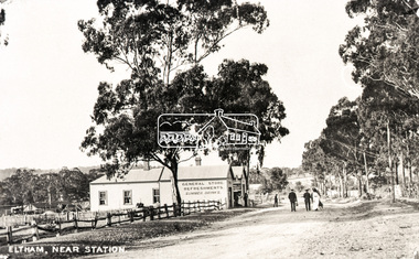
Negative - Photograph, Eltham, Main Road near station, c.1910
View looking north along Main Road, Eltham from near present day Dudley Street. On the immediate left is the railway station. The large weatherboard building on the bend (opposite present-day Arthur Street) with signs for General Store, Refreshments and Summer Drinks painted on the side is Luther and Ada Haley’s General Store and Bakery, built 1902. This was the first building in what is now Eltham’s present shopping town centre. Haley previously ran the General Store and Bakery on the corner of Main Road and York Street until his lease expired and the premises were bought by Mrs Sarah Burgoyne in 1902. The store later was known as Staff's Store. Followed by the saleyards, entrance to station, slaughter yard and William J Capewell’s butcher shop. Contained within the saleyards facing the street, a small shelter with the name H.H. Clark upon it. Horace Harold Clark was the son of Eltham State School’s first Head Teacher, David George Clark. As well as being a farmer, he was an Estate Agent and conducted auction sales, presumably from this shelter. On the eastern (right) side of Main Street is Haley’s Paddock, which was used on occasions for community picnics. Capable of holding 10,000 people, with ample shade and hilly surroundings it was an ideal place for any community gathering such as the State Schools’ Picnic in 1904. A worker from the bakery store is standing in the gateway at the rear of the store observing the photographer. People in the ‘Sunday Best’ are milling in front of the bakery or strolling down the centre of Main Road. The picture was most likely taken on a Sunday. With the opening of the railway to Eltham in 1902, Melbourne residents would regularly enjoy a Sunday excursion journey on the train to Eltham for a day’s outing to the countryside or beyond to Hurstbridge from 1912 when the railway was extended. Picture dated as c.1910 based on similar picture published in the Weekly Times, Feb. 1912. Cross Ref: 609 (looking south), 612, 611 (later stage), 613.Negative black and white film 120 6x9 format 2 stripsAgfa APX 100baker, butcher, eltham, eltham railway station, eltham sale yards, eltham slaughter yard, eltham town centre, general store, haley's paddock, hot water, luther haley, luther haley general store, m.m. clark, main road, railway station, shire of eltham pioneers photograph collection, shops, sign, staffs general store, summer drinks, w.j. capewell -
 Glen Eira Historical Society
Document - Racing Stables In Caulfield
This file contains 3 items. 1/ Document provided by Veterinarian Dr G. G. Heslop about racing stables in the Caulfield area adjacent to the Caulfield Race Course, in both typed and handwritten form. 2/ A letter of request from a Sydney based sports writer Geoff Armstrong for information about the attempted shooting for Phar Lap. 3/ A letter to the Editor in the Glen Eira/Port Phillip Leader dated 02/04/2013 about the proposal to ban horse training from the Caulfield Racecourse.clubs and associations, victorian amateur turf club, racecourses, caulfield race course, racecourse trainers, stables, racehorses, schools, secondary school, caulfield high school, hotels, caulfield club hotel, wattle tree hotel, petrol stations, veterinarian clinic, norman myers veterinarian hospital, baker norma, bence j., bird j., cadby lou, conaghan basil, cameron ron, couseng harry, cox cecil, creighton norman, delaney g., eules darce, farmer h. (dick), fraser mick, foulsham fred, fryer j., gatell harry, garton a. (rod), garland f., godby cecil, godby frank, goodfellow claude, guinane p., hayes t. j., hilton h., hodgkinson george, james jack, jenkins e. j., jennings reg, judd des, jury jack, king frank, mcgregor j. n., mcnamara dave, mcphee sonny, mclaughlin, mulcahy j., murphy geoff, muskett j., parkinson j., phillipson mr., quinlan pat, ralph stan, reid stanley, robinson f., rolfe w. j., sanderson chris, telford w., tie jerry, torr harry, bernborough, black caviar, garryowen, phar lap, purser, revenue, spearfelt, surround, arthur jr., murrel violet, farmer violet, kemball w. r., mcdonald leslie, brockhoff mr., carslake mr., gullifer h., heywood j. g., llord mr., davies mr., palfreman mr., caulfield, caulfield north, caulfield south, carnegie, glen huntly, glenhuntly, eskdale road, balaclava road, bambra road, glen eira road, heywood street, hudson street, hawthorn road, kambrook road, kooyong road, tudor court, lloyds paddock, payne street, park crescent, service street, slaney’s paddock, station street, booran road, ‘moidart’, cadby court, glen huntly road, glenhuntly road, neerim road, ‘cintra’, stephen street, uranda line grove, willgra road, epsom street, lloyds street, lord street, queens avenue, st vincents street, roseberry grove, manchester grove, safeway supermarket, hesop g. g. dr veterinary surgeon -
Glen Eira Historical Society
Document - Hotels, Caulfield
This file contains one item: 1/Handwritten research notes recording details about various hotels in the Caulfield area and environs. Details include handwritten maps and lists of publicans/licensees/nominees. Notes by author unknown and undated. Some of the notes make reference to entries in Sands & McDougall directories.r. k. cole hotel collection, london tavern hotel, london tavern and store, glen huntly road, caulfield, sycamore street, hawthorn road, dandenong road, derby road, koornang road, caulfield club hotel, rosstown hotel, royal hotel, the vine beer house, the vine caulfield hotel, newton h., balaclava road, bambra road, mirrambeena road, murrumbeena road, poath road, the tam o’shanter hotel, wilston street, farmers’ arms home hotel, chestnut street, hooper street, thompson william, martin p. j., orme frederick, orme fred, nicholls william henry, mullins john, armstrong john, egan james, westwood james, westwood ellen, greenberg david, greenberg sydney, greenberg rose, spamm cath, pitter mabel, morrow andrew, morrow andy, feddan george curtis, guess john, evans rowland, evans roland, riordan john, smith george elms, bedwell c., griffen frederick, connelly p. h., uhrbrock f., swift charles, gregor f., hazlett david, moore l., harley susan, mott h., nichols william henry, ross peter mclean, elsternwick, mcnamara margaret, mcnamara v., stevens catherine, mcgregor f., clarice george -
Glen Eira Historical Society
Article - MCKINNON
Brief typed history of McKinnon settlement taken from Moorabbin A Pictorial History 1862-1994 by John Cribben. Includes photocopied pages of railway gates, five land estate flyers and an article from the McKinnon Progress, undated.mckinnon, cribben john, crop production, markets, farmers, elster creek, mcmillan archibald, thomas street, centre road, wheatley road, vineyards, south road, ormond, brighton, moorabbin, irish, immigrants, bentleigh, priests, hanrahan pierce, hanrahan johanna, caroll michael, caroll catherine, howes eliza, howes john, howes edward, shanahan denis, shanahan ellen, gould james, gould catherine, howes george, bignell road, jasper road, tucker road, mcguiness family, quinn family, halinan family, malane family, inns, the gardeners arms, mckinnon hotel, bent james, bent thomas, tickets of leave, murray road, were nicholas, sargood family, ripponlea, mansions, elsternwick, st. stephens’ common school, church of england, school houses, evelyn street, st. john’s anglican church, telegraph offices, post offices, state schools, manchester road, north road, nicholls buildings, rivers frank, rivers ray, shops, pridgeon mr., elm grove, sobrin mr., clark misses, greaves bakery, armitage mrs., rout mr., tunnicliffe mrs., lance’s milk bar, johnson’s hardware shop, stiringer mrs., white horrie, robinson’s, mcinnerney’s flower shop, jean darling’s cakes, wyles jim, mckinnon progress association, glen orme avenue, ormond theatre, theatres, lester harry, the plaza, railway crossing, railway gates, wright street, nichols l., builders, pine grove, halls, st. elmo estate, patterson station estate, patterson road, brewer road, purton road, clee hill estate, railway park, hawthorn grove, wattle grove, elm grove, learys estate, manchester road, selkirk avenue, masters estate, lancaster street, moylan street, moorabbin railway crossing -
Glen Eira Historical Society
Letter - CAULFIELD YOUTH COUNCIL
This file contains six items: 1/A copy of the Caulfield Youth Council Statement of Purposes. 2/Correspondence dated 07/10/1981 regarding the Community Youth Support Scheme and levels of funds received for 1982. 3/Two financial statements for the Caulfield Youth Council. One dates from 01/03/1984 – 18/04/1985 and the second dates from 01/07/1986 – 30/06/1987. Contains handwritten annotations and signature of L.Goodfellow, dated 18/04/1985. 4/Three Caulfield Youth Council Meeting minutes from the period 04/10/1984 to 18/04/1985. 5/A copy of Caulfield Youth Council’s 1987 A.G.M Agenda which includes the 1986 A.G.M minutes and the Youth Development Officer’s Report. Contains handwritten annotations, author unknown. 6/Miscellaneous information that perhaps would have been provided and discussed at a Caulfield Youth Council meeting, date and sources unknown. One is the constitution for the Southern Region Youth Action Council and the other is an Appendix to the White Paper on unemployment.caulfield youth council, caulfield festival, caulfield city caulfield, goodfellow l., neale ray, caulfield, brain ian, c.y.c, carr kate, caulfield high school, nevinson wayne, howard kerry, musgrove wendy, bowman jenny, welham roberta, schaeffer rema, ferdinands ken, bigeni anne, carr mandy, carr steven, ecimovic mitch, larson john, campbell jack, o’neill wells, hanevski gena, diamond jack, marek waldemar, smith vicky, carr stephen, jacobs david, williamson dave, williamson david, caulfield south, gunther lisa, farmer reg, feder stephen, cook damien, atteins ben, caulfield youth council incorporated, caulfield town hall staff house, farmer reggie, carr manda, carr kate, noulton peter, schaffer renna, feden stephen, kershaw tracey, musgrave wendy, jackson clive, loursen john, enright danny, doman pam, sheehan tony, st. kilda east, campbell fiona, mcinerney john, mardling matthew, shaffer rena, henevski gina, shawki enas, melvin david, tanner ted, maple street, smith wendy, goodfellow loris, scheaffer rema, atkins ben, gibbs brett, miller nicki, nugent virginia, lechmus julian, caulfield park, clay liz, campbell a, st. georges road, elsternwick, higgins, shipton roger, spencer david, cox lisa, ellmer kay, enion paul, ashton kim, toulidakis george, wilkin john, conway shaun, tesoriero dominic, beaumont kim, skinner simon, mcquarrie kay, wiseman anthony, garland nigel, merifield rod, ashton matthew, schaffer rema, leclerc lorraine, loorham warren, tanner ted mr, nye lyn, ellmer ray, youth of caulfield, ellmer kerry, campbell j, seidel bernie, caulfield lions, caulfield lions club, glenhuntly, caulfield council, matzirodoz arti, kids in caulfield, k.i.c, nisbet karen, the lions club, smith loretta, leitch meaghan, sallis richard, city of caulfield, caulfield city council, young adults, youth clubs, youth, community services, meetings, civic establishments, community organisations, local government, local officials and employees, mayors, financial documents, teenagers -
Glen Eira Historical Society
Document - Lees Family
A seven page reprinted article by Jan Rigby, on the Lees Family, who were early pioneers, and pioneer market gardeners in McKinnon and Bentleigh 1850-2003. Includes footnotes and references author Jan Rigby used for her research.lees family, pioneers, market gardens, mckinnon, bentleigh, lees jack allan, briggs vera victoria, lees james henry, tobin linda doris, mcclelland vera auraria, lees leonard william, rigby jan, lees james, lees william, bentleigh, jasper road, centre road, harwood j., branbury thomas, mckinnon road, wheatley road, mckinnon railway, east bentleigh, convicts, crop production, farmers, vineyards, viticulture, bent james, mckinnon road, elster creek, hellins edward, inns, gardeners arms, brighton cemetery, cemeteries, guerin mary, quirk michael, quirk patrick, quirk catherine, quirk daniel, quirk edward, quirk daniel snr., lees mary, slab huts, lees joseph, lees joe, east bentleigh school, primary schools, ring catherine, ring kate, stables, lees bill, lees tom, lees james henry, lees jim, ormond state school, wagons, cruickshanks nursery, nurseries, church of christ, ormond, carlton street, lees street, ring charles, rout charlotte, horse racing, lees george, lees stan, crop production, nicholson street, lees street, cowie william, lees leonard william, lees len, lees vera, lees linda doris, lees jack allen, lees vera victoria, mckinnon cricket club, sporting clubs, bentleigh club, masonic lodge, thomas street, edwards george, nurserymen, chinese community, market gardeners, j.h. lee and sons, lee floss, lees iris, centre road, bent thomas -
 Glen Eira Historical Society
Document - Thomas, George
This file contains three items Hand written report on property of George Thomas in Orrong Road, dated 04/06/1985, author unknown Photocopy of four page contract and conditions of sale for lot 262 county of Burke Parish of Prahran. George Thomas property was sold to George William Taylor, dated 20/10/1881 The original photograph of a water colour painting of home and garden of George Thomas, Orrong Road, Caulfield by W. Tibbits 1876thomas eric f, thomas george, beemery park, orrong road, seymour road, allison road, mullaly j, j. fulton, taylor george william, warrein road, north road, stone adelaide, orrong road t. fulton, business, farmers, farm workers, farms, gardeners, subdivisions, land subdivision, land sales, land prices, land development, land developers -
Glen Eira Historical Society
Book - Thomas, George
History and biography of George Thomas senior and junior. Also gives details of the siblings, family tree of few siblings, and some plans of Thomas properties. A forty-four page book published by Eric F. Thomas in 1986thomas eric f., thomas george, thomas george snr, thomas george jnr, land surveyors, land subdivision settlements, estate of klaterville, brighton estate, churches, church groups, mckinnon road, thomas road, thomas street, tucker road, orrong road, glen eira road, st marys church of england glen eira road, gardeners, farmers, caulfield, seymour road, thomas george alfred, thomas adelaide, warrein road, north road, thomas percival theodore, thomas elsie adelaide, thomas arthur gilbert, quarries, stone quarries, agricultural activities, methodist church, church groups, thomas cecilia hilda, thomas stanley charles, thomas bertha alice, melbourne street, murrumbeena, murrumbeena methodist church, sunday schools, sunday schools teacher, moonya road, thomas amy ida mary, women’s christian temperance union, thomas edith minnie, bible society, thomas william henry, linacre jane ann -
 Federation University Historical Collection
Book, Guide to Ballarat the Beautiful, 1923, 1923
... george farmer... biscuits ballarat eisteddfod george farmer ballarat botanical ...The image of Ballarat Trustees relates to a building on the corner of Mair and Lydiard Streets. In 2010 it was used as Cuthberts law firm.Grey/green soft covered book. Includes photographs and map. Themes include: Ballarat History pre gold, mining, Eureka Stockade, Lake Wendouree, South Street, Grand National Eisteddfod of Australasia, schools, Black Hill, Lake Burrumbeet, Creswick, Buninyong. Illustrations and advertisement include: Sturt Street,James Smith, Ballarat Town Hall, Ballarat East Town Hall, Rowlands, Ballarat brewing Co., Royal Standard Brewery, steam train, Lake Wendouree, J.S. Vickery & Son, trout, Berry, Anderson & co., Ballarat Botanical Gardens and hot houses, Claxton Memorial Fountain, statues, New Imperial Gold Mine, Art Gallery of Ballarat, St Patrick's College, Ballarat Grammar School, Ballarat School of Mines, Ballarat College, Sunnyside Woollen Mills, Ballarat Agricultural High School, Passenger Steamer on Lake Wendouree, Moorabool Falls, Lal Lal Falls, Grosvenor Square, Netherby, Buninyong, Ballarat Motor Garage.ballarat, cuthberts, ballarat trustees, sturt street, tram, trams, ballarat town hall, crag's hotel, sun foundry, eureka aerated waters and brewing co, d. lem, chinese practioner, chinese herbalist, hugh v. mckay, sunshine harvester, gordon brothers, central business college, george hotel, edwards pyrites furnace, long's biscuits, ballarat eisteddfod, george farmer, ballarat botanical gardens, eureka stockade, lake wendouree, ballarat school of mines, moorabool falls, kirks reservoir, ballarat post office, hepburn lagoon, star of the east mine, emu river, ballarat observatory, statues, angus' rialto cafe, carlyon's hotel, clarendon ladies' college, j.e, sang, ballarat coffee palace, stansfield and smith, ballaray brewing company, phoenix brewery, rotal standard brewery, john macleod co, robert sim and co, cobb and co\eagle foundry, j.j. goller and co., mt buninyong lookout, ballarat town hall ballarat east gardens, hot house, glass house, statuary pavilion new imperial gold mining co.,, art gallery of ballarat, st patrick's college, ballarat agricultural high school, lake wendouree steamer, grass trees at mt clear, mount clear, lake burrumbeet, newlyn reservoir trout, lal lal falls, grosvenor square, netherby, ramelli's motor garage, buninyong gold obelisk, memorial, imperial gold mine, botanical gardens lily pond and fernery -
 Federation University Historical Collection
Photograph - Photographs, Images relating to the Vincent Family of Warrenheip and Durham Lead, Victoria
Richard and Amelia (Job) Vincent arrived from Cornwall in 1855. richard was a farmer at Warrenheip. Their children were Richard, Mary, Thomas Job (died in infancy), Thomas Job, Annie, Emily, Selina, Amelia, Ada and George. Annie Vincent married Edward huggins in 1884. Their children were Edith, Robert, Ada, George, Stella, Roy, Lillian, Harold and Ronald. Vincent Avenue, Mount Helen, is named after this family.Provides a record of the descendants of Richard and Amelia Vincent who arrived from Cornwall England in 1855 and became farmers at Warrenheip. Photographs capture dimensions of the life of Councillor Richard Vincent, who became President of the Buninyong Shire Council in 1953.Black and white and colour photographs of people, letters and newspaper clippings depicting dimensions of the Vincent family history .1) Photograph of Vincent family home .2) Photograph of the Bungaree and District Historical Society Heritage Wall .3) Photograph of the Vincent family plaque on the Bungaree and District Historical Society Heritage Wall .4) Photograph of information about the Bungaree and District Historical Society Heritage Wall .5) Photograph of local football l team .6) Photograph of the Mt Buninyong R. F. B. .7) Photograph of haystack .8) Photograph of letter from Shire of Buninyong to Mr R Vincent regarding the naming of Vincent Road .9) Photographs of newspaper clippings concerning Cr Vincent becoming the next Buninyong President richard vincent, haystack, warrenheip, buninyong shire council, amelia vincent, bungaree pioneers wall, mt buninyong rural ire brigade, warrenheip football club, vincent, family history, genealogy -
Federation University Historical Collection
Document, Heather Holst, 'Save the people': E.S. Parker at the Loddon Aboriginal Station, 2008
A chapter from Aboriginal History 2008, Volume 32edward stone parker, e.s. parker, loddon aboriginal station, mount franklin aboriginal station, aboriginal protectorate, port phillip protectorate, loddon station, mary cooke woolmer, joseph parker, mary parker, franklinford, dja dja wurrung, hannah edwards, james bodkin, hannah parker, mount franklin house, edward parker, john knox, tommy farmer, beembarmin, yerrebulluk, norah farmer, aboriginal farmers, coranderrk, willie parker, kolain, george robinson, -
 City of Moorabbin Historical Society (Operating the Box Cottage Museum)
Photograph, B&W, Anna Box 1849 - 1919, c1912
Anna Box 1849- 1919 was born in Withyham, Sussex England had her 7th birthday en route from Liverpool to Australia. George Box 1808-1867 of Sussex England, married Mary Cripps in 1831 and with 3 three of their 4 four sons and 3 three of their 4 four daughters left Liverpool in the Sailing Ship 'Atlanta' in March 1856 to begin a new life in Melbourne, Victoria , Australia. Their baby daughter Cecilia Lydia died a few days later. Caroline Box, the eldest daughter, remained in England working as a cook until she joined the family in Australia in 1863. William Box 1834-1902, the eldest son of George Box, married Elizabeth Avis 1833- 1914 and they resided in Box Cottage 1865 -1914 where they established a market garden and raised 13 children. William and Elizabeth had emigrated in 1854 so George worked on their market garden before setting up in Patterson Road. Sadly Mary drowned in a water hole only 4 months after their arrival in Brighton. It is supposed that Elizabeth helped George raise the children while he established his market garden. George died from Tetanus following an infected broken leg caused by falling from his dray in 1867. Anna was a dressmaker and in 1881 she married Henry Pay , a painter, from London and they had 3 children . In 1907 the family lived on a 30acre property in Ringwood. which Anna bequeathed to her children. – Beatrice, Norman and Laura. In 1911 they moved to Surrey Hills where Anna died in 1919. Henry died in 1935 in Montrose where he was living with his son Norman Henry Pay, a farmer . Box Cottage Museum, a reconstruction of an early settler hut, is named after the Box family who resided there 1865 -1913 . William Box who, with his wife Elizabeth Avis Box and 13 children, lived and farmed on the block of land in Jasper Road, East Brighton ( now McKinnon / Ormond) that was part of the Henry Dendy Special Survey 1841. George Box 1808-1867 migrated in 1856 and worked with his son William Box until he established a market garden in Patterson Rd . East Brighton ( now Bentleigh). Anna Box –Pay was the 3rd daughter of George and Mary Box. A black and white photograph of Anna Box 1849-1919nilbox anna, pay henry, pay norman, box william, box elizabeth avis, box george, box mary, moorabbin, bentleigh, brighton, ormond, market gardeners, pioneers, early settlers, withyham sussex england, ringwood melbourne, pay beatrice, pay laura, st kilda, melbourne, -
 City of Moorabbin Historical Society (Operating the Box Cottage Museum)
Photograph - Photographs x2, B&W, possibly Anna Box and Henry Pay, c1881
Anna Box 1849- 1919 was born in Withyham, Sussex England had her 7th birthday en route from Liverpool to Australia. George Box 1808-1867 of Sussex England, married Mary Cripps in 1831 and with 3 three of their 4 four sons and 3 three of their 4 four daughters left Liverpool in the Sailing Ship 'Atlanta' in March 1856 to begin a new life in Melbourne, Victoria , Australia. Their baby daughter Cecilia Lydia died a few days later. Caroline Box, the eldest daughter, remained in England working as a cook until she joined the family in Australia in 1863. William Box 1834-1902, the eldest son of George Box, married Elizabeth Avis 1833- 1914 and they resided in Box Cottage 1865 -1914 where they established a market garden and raised 13 children. William and Elizabeth had emigrated in 1854 so George worked on their market garden before setting up in Patterson Road. Sadly Mary drowned in a water hole only 4 months after their arrival in Brighton. It is supposed that Elizabeth helped George raise the children while he established his market garden. George died from Tetanus following an infected broken leg caused by falling from his dray in 1867. Anna was a dressmaker and in 1881 she married Henry Pay , a painter, from London and they had 3 children . In 1907 the family lived on a 30acre property in Ringwood which Anna bequeathed to her children. – Beatrice, Norman and Laura. In 1911 they moved to Surrey Hills where Anna died in 1919. Henry died in 1935 in Montrose where he was living with his son Norman Henry Pay, a farmer . Box Cottage Museum, a reconstruction of an early settler hut, is named after the Box family who resided there 1865 -1913 . William Box who, with his wife Elizabeth Avis Box and 13 children, lived and farmed on the block of land in Jasper Road, East Brighton ( now McKinnon / Ormond) that was part of the Henry Dendy Special Survey 1841. George Box 1808-1867 migrated in 1856 and worked with his son William Box until he established a market garden in Patterson Rd . East Brighton ( now Bentleigh). Anna Box –Pay was the 3rd daughter of George and Mary Box. 2 black and white photographs that may be of A ) Anna Box and B) her husband Henry Pay A) nil B) J P LIND Photo 82 Swanston St.box anna, pay henry, pay norman, box william, box elizabeth avis, box george, box mary, moorabbin, bentleigh, brighton, ormond, market gardeners, pioneers, early settlers, withyham sussex england, ringwood melbourne, pay beatrice, pay laura, st kilda, melbourne -
 City of Moorabbin Historical Society (Operating the Box Cottage Museum)
Photographs, 2 x B&W, possibly Anna Box 1849 - 1919, c1880
Anna Box 1849- 1919 was born in Withyham, Sussex England had her 7th birthday en route from Liverpool to Australia. George Box 1808-1867 of Sussex England, married Mary Cripps in 1831 and with 3 three of their 4 four sons and 3 three of their 4 four daughters left Liverpool in the Sailing Ship 'Atlanta' in March 1856 to begin a new life in Melbourne, Victoria , Australia. Their baby daughter Cecilia Lydia died a few days later. Caroline Box, the eldest daughter, remained in England working as a cook until she joined the family in Australia in 1863. William Box 1834-1902, the eldest son of George Box, married Elizabeth Avis 1833- 1914 and they resided in Box Cottage 1865 -1914 where they established a market garden and raised 13 children. William and Elizabeth had emigrated in 1854 so George worked on their market garden before setting up in Patterson Road. Sadly Mary drowned in a water hole only 4 months after their arrival in Brighton. It is supposed that Elizabeth helped George raise the children while he established his market garden. George died from Tetanus following an infected broken leg caused by falling from his dray in 1867. Anna was a dressmaker and in 1881 she married Henry Pay , a painter, from London and they had 3 children . In 1907 the family lived on a 30acre property in Ringwood. which Anna bequeathed to her children. – Beatrice, Norman and Laura. In 1911 they moved to Surrey Hills where Anna died in 1919. Henry died in 1935 in Montrose where he was living with his son Norman Henry Pay, a farmer . Box Cottage Museum, a reconstruction of an early settler hut, is named after the Box family who resided there 1865 -1913 . William Box who, with his wife Elizabeth Avis Box and 13 children, lived and farmed on the block of land in Jasper Road, East Brighton ( now McKinnon / Ormond) that was part of the Henry Dendy Special Survey 1841. George Box 1808-1867 migrated in 1856 and worked with his son William Box until he established a market garden in Patterson Rd . East Brighton ( now Bentleigh). Anna Box –Pay was the 3rd daughter of George and Mary Box. 2 black and white photographs that Avis Box Leigh thinks may be Anna Box c1880A unreadable B Ferry 49 Elizabeth St . Melbournebox anna, pay henry, pay norman, box william, box elizabeth avis, box george, box mary, moorabbin, bentleigh, brighton, ormond, market gardeners, pioneers, early settlers, withyham sussex england, ringwood melbourne, pay beatrice, pay laura, st kilda, melbourne -
 City of Moorabbin Historical Society (Operating the Box Cottage Museum)
Photograph, Black & White, Cheltenham State School Grade 3 5/3/1917, 1917
Ada Pearling Pickering ( G Box ) Stephen Charman, 1821-1906 a market gardener, donated land for the first Methodist Chapel, Cemetery and School in Charman Rd Cheltenham 1855. The enrolment was 36 pupils with Mr Frederick Meeres as Teacher. 1863 the school is called Beaumaris Common School No 84 with 70 pupils and Walter Meeres as Teacher. 1869 another 2 acres in Charman Road were granted by the Education Board and brick building built . 1872 State School 84 Beaumaris was increasing enrollments and 1878 a new brick school was built to accommodate 174 pupils and the name changed to Cheltenham State School No.84 1894 Mentone State School No.2950 amalgamated with Cheltenham SS No.84. 1910 the buildings were in disrepair, overcrowding was increasing and renovations were made 1912 with further additions in 1925 and 1937. Post WW11 extra prefabricated Classrooms were added as enrollment increased to 1038 in 1955.. Cheltenham East State School 4754 was opened as housing development spread over the City of Moorabbin . (J.Larson Sandringham HS) Ada Pearling Pickering was descendant of the George Box Family who migrated in 1850,s and established market gardens in the Brighton area of Dendy's Special Survey 1841 . 1855 Stephen Charman donated land to the Methodist Church so that a School could be established to educate the children of the early settler market gardeners and farmers in the Cheltenham area . Education was valued by the general community and as well as schools they established mechanics Institutes and Libraries in Moorabbin Shire. Cheltenham State School No. 84 was among the first schools in MelbourneBlack & White photograph of pupils at Cheltenham State School No.84 Grade 3 1917 with Ada Pickering a descendant of the Box family early settlershand written Ada Pearling Pickeringbox george, box william, box elizabeth, pickering ada, city of moorabbin, county of bourke, moorabbin roads board, parish of moorabbin, shire of moorabbin, henry dendy's special survey 1841, were j.b.; bent thomas, o'shannassy john, king richard, charman stephen, highett william, ormond francis, maynard dennis, cheltenham state school no.84, methodist chapel cheltenham, methodist school cheltenham, beaumaris west state school, meeres frederick, meeres walter, education, early settlers, -
 City of Moorabbin Historical Society (Operating the Box Cottage Museum)
Photograph, Black & White , Cheltenham State School No. 84 Prep Course A c 1915 Ada Pickering, c1915
Ada Pearling Pickering was a descendant of George Box family who migrated c 1850 and established market gardens in the Brighton area of Dendy's Special Survey 1841. Stephen Charman, 1821-1906 a market gardener, donated land for the first Methodist Chapel, Cemetery and School in Charman Rd Cheltenham 1855. The enrolment was 36 pupils with Mr Frederick Meeres as Teacher. 1863 the school is called Beaumaris Common School No 84 with 70 pupils and Walter Meeres as Teacher. 1869 another 2 acres in Charman Road were granted by the Education Board and brick building built . 1872 State School 84 Beaumaris was increasing enrollments and 1878 a new brick school was built to accommodate 174 pupils and the name changed to Cheltenham State School No.84 1894 Mentone State School No.2950 amalgamated with Cheltenham SS No.84. 1910 the buildings were in disrepair, overcrowding was increasing and renovations were made 1912 with further additions in 1925 and 1937. Post WW11 extra prefabricated Classrooms were added as enrollment increased to 1038 in 1955.. Cheltenham East State School 4754 was opened as housing development spread over the City of Moorabbin . (J.Larson Sandringham HS) 1855 Stephen Charman donated land to the Methodist Church so that a School could be established to educate the children of the early settler market gardeners and farmers in the Cheltenham area . Education was valued by the general community and as well as schools they established mechanics Institutes and Libraries in Moorabbin Shire. Cheltenham State School No. 84 was among the first schools in Melbourne. Ada Pickering was descendant of the early settler Box family who migrated c 1850Black & White Photograph of pupils at Cheltenham State School No 84 c 1915 in Prep Course A with Ada Pickeringback Ada Pearling Pickering box george, box william, box elizabeth, pickering ada, city of moorabbin, county of bourke, moorabbin roads board, parish of moorabbin, shire of moorabbin, henry dendy's special survey 1841, were j.b.; bent thomas, o'shannassy john, king richard, charman stephen, highett william, ormond francis, maynard dennis, cheltenham state school no.84, methodist chapel cheltenham, methodist school cheltenham, beaumaris west state school, meeres frederick, meeres walter, education, early settlers, -
 City of Moorabbin Historical Society (Operating the Box Cottage Museum)
Newsletter, City of Moorabbin Historical Society Aug 2008, August 2008
The City of Moorabbin Historical Society was formed c 1960 by a group of Moorabbin residents who were concerned that the history of the area should be preserved. A good response to a call for items related to the historical area of Moorabbin Shire brought donations of a wide variety of artefacts which are now preserved by the current members of CMHS at Box Cottage Museum . Helen Stanley, Secretary of CMHS, began producing a Newsletter for members in April 2007 to provide current information and well researched items of historical interest. Helen Stanley has produced a bi-monthly Newsletter, 2007 - 2013, for the members of the City of Moorabbin Historical Society that contains well researched interesting historical items, notification of upcoming events, current advice from Royal Australian Historical Society , Museums Australia Victoria and activities of Local Historical Societies. The Newsletter is an important record of the activities of the CMHS. The Blackman family were early settlers in Moorabbin Shire A4 paper printed both sides x1. Issue 8 of the bi-monthly, City of Moorabbin Historical Society Newsletter produced by Society member and Secretary, Mrs Helen Stanley in August 2008. Notices of a talk by Dorothy Booth, “ The Historic Mentone Railway Gardens’ on August 31st and a request for volunteers to begin an Inventory of the Box Cottage artefacts and to assist at upcoming Open Days. An excerpt from the CMHS Newsletter March 1965 ‘ Three Pieces of Paper’, by Mrs Nance Blackman, a member, describing items from “The Moorabbin News” ‘ 1907 that included The Cheltenham Butter Factory, and advertisements aimed at the local people and their occupations. Note is made of 3 businesses run by Women – butcher, milk delivery and a ‘delicatessen’ - and an ‘Oriental Laundry’ in Cheltenham, as well as the trading hours for shops and weekly wages. Gas light and candles were in common use because Electricity did not come to Bentleigh until 1916 and several Fire Brigades were formed in the Shire. A photocopied photograph of an Electric Power pole c1930.CITY of MOORABBIN HISTORICAL SOCIETY / AUGUST 2008 NEWSLETTER city of moorabbin historical society, stanley helen, melbourne, moorabbin, mentone, mordialloc, cheltenham, ormond, bentleigh, market gardeners, farmers, dairymen, confectioner, pioneers, early settlers, moorabbin shire, blackman nance, box cottage museum, highett, booth dorothy, mentone railway station gardens, cheltenham butter factory, beazley hannah, redstron mrs., bickerton mrs., oriental laundry cheltenham, biehl mr., matthews mr., gas-light, electric light, smith j.l., journeaux james, king george, grommann’s hotel mordialloc, telephones, fire brigades -
 Bendigo Historical Society Inc.
Newspaper - Lydia Chancellor collection: Wootton Lansell built this house
Wootton Lansell was a sailor born in Kent, England in 1825. after travelling to Nova Scotia and the Californian goldfields, Wootton arrived in Australia in 1850. For 18 months he worked as a mounted trooper in Adelaide before coming to Bendigo in 1850. He also spent time on the Ovens goldfields before returning to Adelaide for three months. He returned to Bendigo in 1854 and had some success in his hunt for gold before working as a carpenter. In 1854 he married Helen Hall He invited his brothers, George and William to join him in Bendigo and they initially set up a butchery, soap and candlemakers business in View point. George went on to become the "King of Quartz Mining'. Wootton eventually became a farmer at Leichardt, where he built "Myrtle Villa", but retained his interest in mining becoming a director of many mining and dredging companies. He died 14/12/1907.Bendigo Advertiser from Saturday November 29,1969. Article titled "Wootton Lansell built this house by Toora. In it the author details the life of Wootton Lansell and the building of Myrtle Villa.In red pen at top: 29-11-69lansell, myrtle villa, bendigo houses -
 Ballaarat Mechanics' Institute (BMI Ballarat)
George Richmond in Hames and Woodward
This photograph is held in the Ballaarat Mechanics' Institute Audio Visual Collection. Please contact BMI for all print and usage inquiries. BMI librarian Rosemary McInerney's father George Richmond ran this furnitue business on Armstrong St Nth. Here are his reminiscences of that shoppping area from The Courier March 1st 1978 THE GOOD OLD DAYS IN ARMSTRONG ST. NORTH Mr George Richmond began work in Armstrong street north as a lad in knickerbockers in 1926. He started with Hames and Woodward, a piano, music and record shop, which he took over when both Hames and Woodward died during the war. Mr Richmond was guest speaker at an informal dinner of the Armstrong St North Traders Association held at the Victoria Hotel on Monday night. At the meeting he was made a life member of the association, with which he had been involved since its inception in 1930. “I can remember when a man on a bicycle with a little ladder on his backrode up the street with a long stick and turned on the gas lights under the verandahs,” he said. “It was around that time when there used to be a little man with a broom walking up and down the street, sweeping away what was left behind by horses. “There also used to be a bellringer who would walk up and down Armstrong street announcing a sale in a shop. He used to have a tall black hat, a large black frock coat and had a large mustache.” “Up to 1936, there used to be regular visits by street musicians, who were usually good for a few laughs.” “The last musicians to come through were an Italian trio, who were very good.” Mr Richmond said the depression was a sad time for Armstrong street. “A lot of people had to put their properties up for sale, because not many people could afford to buy things like records then,” he said. Mr Richmond said Fridays were very busy then as it was market day for hundreds of farmers in the area. “The hotels put on extra groomsmen for the stables, and standing in the store I could smell the beer and tobacco drifting down from the hotels.”ballarat, hames, woodward, furniture, richmond, armstrong st nth, shop -
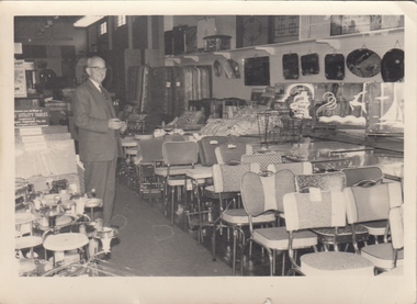
 Ballaarat Mechanics' Institute (BMI Ballarat)
Front View of Factory
... george farmer... BMI for all print and usage inquiries. ballarat george farmer ...This photograph is from the Max Harris Collection held by the Ballaraat Mechanics' Institute. Please contact BMI for all print and usage inquiries.ballarat, george farmer, building, eureka st, ballarat east, horse, factory -
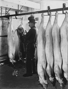 Ballaarat Mechanics' Institute (BMI Ballarat)
Inspection of Pigs
... George Farmer... BMI for all print and usage inquiries. Ballarat pigs George ...This photograph is from the Max Harris Collection held by the Ballaraat Mechanics' Institute. Please contact BMI for all print and usage inquiries.ballarat, pigs, george farmer, eureka st, ballarat east, factory, 1910 -
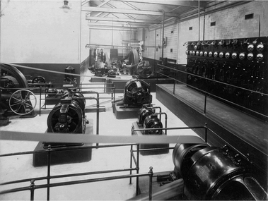 Ballaarat Mechanics' Institute (BMI Ballarat)
Machinery Room View 1
... George Farmer... George Farmer Eureka St Ballarat East factory 1910 Machinery Room ...This photograph is from the Max Harris Collection held by the Ballaraat Mechanics' Institute. Please contact BMI for all print and usage inquiries.ballarat, machinery room, george farmer, eureka st, ballarat east, factory, 1910 -
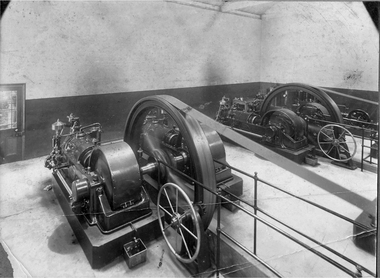 Ballaarat Mechanics' Institute (BMI Ballarat)
Machinery Room View 2
... George Farmer... George Farmer Eureka St Ballarat East factory 1910 Machinery Room ...This photograph is from the Max Harris Collection held by the Ballaraat Mechanics' Institute. Please contact BMI for all print and usage inquiries.ballarat, machinery room, george farmer, eureka st, ballarat east, factory, 1910 -
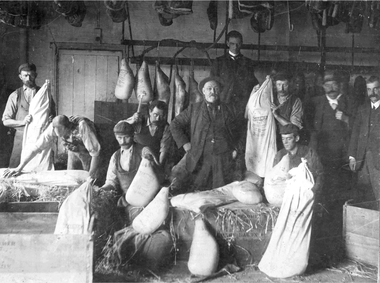 Ballaarat Mechanics' Institute (BMI Ballarat)
Packing & Despatch Room (c1910)
... George Farmer... Despatch Room 1910 George Farmer Eureka St Ballarat East factory ...This photograph is from the Max Harris Collection held by the Ballaraat Mechanics' Institute. Please contact BMI for all print and usage inquiries.ballarat, packing, despatch room, 1910, george farmer, eureka st, ballarat east, factory