Showing 122 items matching "greensborough roads board"
-
 Greensborough Historical Society
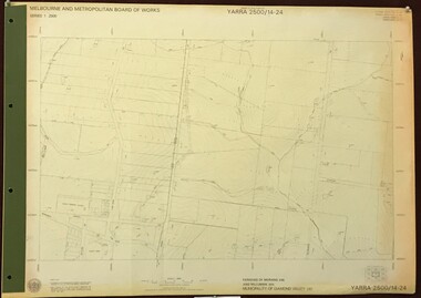
Map, Melbourne and Metropolitan Board of Works. Survey Division, MMBW, Yarra 2500 / 14.24. Plenty, 1979_05
Melbourne and Metropolitan Board of Works. Yarra 2500 [base map] 14.24. Plenty. Parishes of Nillumbik 3310 and Morang 3183. Municipality of Diamond Valley 257. Prominent streets include: Heard Road, Hillmartin Road and Yan Yean Road. Features include Plenty Primary School and Plenty Park.MMBW Map in 1:2500 [scale] series. Cream parchment with green tape reinforcing on edges and punched holes on left edge.mmbw, melbourne and metropolitan board of works, shire of diamond valley, plenty - maps -
 Greensborough Historical Society
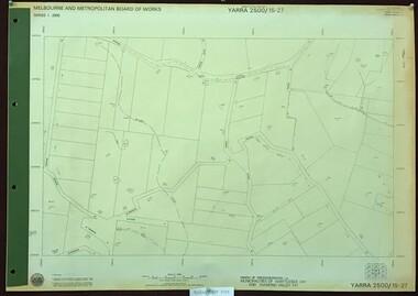
Map, Melbourne and Metropolitan Board of Works. Survey Division, MMBW, Yarra 2500 / 15.27. Yarrambat, De Fredricks Lane, 1977_10
Melbourne and Metropolitan Board of Works. Yarra 2500 [base map] 15.27. Yarrambat, De Fredricks Lane. Parish of Greensborough 2724. Municipality of Diamond Valley 257 and Whittlesea 239. Prominent streets include: De Fredricks Lane, Astons Road and Bannons Lane. Features include Scrubby Creek.MMBW Map in 1:2500 [scale] series. Cream parchment with green tape reinforcing on edges and punched holes on left edge.mmbw, melbourne and metropolitan board of works, shire of diamond valley, yarrambat - maps -
 Greensborough Historical Society
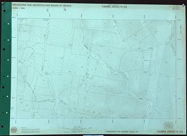
Map, Melbourne and Metropolitan Board of Works. Survey Division, MMBW, Yarra 2500 / 15.26. Yarrambat, Hacketts Road, 1978_07
Melbourne and Metropolitan Board of Works. Yarra 2500 [base map] 15.26. Yarrambat, Hacketts Road. Municipality of Diamond Valley 257. Prominent streets include: Black Gully Road, Hacketts Road and Collins Lane. Features include Scrubby Creek.MMBW Map in 1:2500 [scale] series. Cream parchment with green tape reinforcing on edges and punched holes on left edge.mmbw, melbourne and metropolitan board of works, shire of diamond valley, yarrambat - maps -
 Greensborough Historical Society
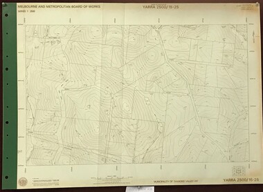
Map, Melbourne and Metropolitan Board of Works. Survey Division, MMBW, Yarra 2500 / 15.25. Yarrambat, Black Gully Road, 1978_07
Melbourne and Metropolitan Board of Works. Yarra 2500 [base map] 15.25. Yarrambat, Black Gully Road. Municipality of Diamond Valley 257. Prominent streets include: Black Gully Road, Ironbark Road and Murray Road. MMBW Map in 1:2500 [scale] series. Cream parchment with green tape reinforcing on edges and punched holes on left edge.mmbw, melbourne and metropolitan board of works, shire of diamond valley, yarrambat - maps -
 Greensborough Historical Society
Map, Melbourne and Metropolitan Board of Works. Survey Division, MMBW, Yarra 2500 / 15.24. Diamond Creek, Grassy Flat Road, 1978_02
Melbourne and Metropolitan Board of Works. Yarra 2500 [base map] 15.24. Diamond Creek, Grassy Flat Road. Parish of Nillumbik 3310. Municipality of Diamond Valley 257. Prominent streets include: Everleigh Drive, Broad Gully Road and Clyde Street. Features include the Diamond Creek, Nillumbik Park and Diamond Creek Reservoir.MMBW Map in 1:2500 [scale] series. Cream parchment with green tape reinforcing on edges and punched holes on left edge.mmbw, melbourne and metropolitan board of works, diamond creek - maps, shire of diamond valley -
 Greensborough Historical Society
Map, Municipality of Heidelberg Plan No. 480, 17/10/1948
Map shows streets, buildings, river and major drainage easements in area covered by West boundary Sellars Street, North boundary Yando Street & South boundary Grimshaw Street. Adjoins Map No. 481 to East. Black & white map, features marked in green, gradients in red. Scale: 160 feet to 1 inchgreensborough -
 Greensborough Historical Society
Map, Municipality of Heidelberg Plan No. 481, 23/9/1949
Central area of Greensborough, South boundary Grimshaw Street, showing river and buildings in green and gradients in red. Adjoins Map No. 480 to West.Black & white map with features in red and green. Scale: 160 feet to 1 inch.greensborough, grimshaw street greensborough -
 Greensborough Historical Society
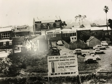
Photograph, Greensborough Pool site, 1959c
The site of the Greensborough swimming pool taken from the corner of Grimshaw Street and Para Road. The barometer board shows the amount needed by public subscription. The two storey hall in the centre back had been the Rechabite Hall, later Masonic Hall then Ashril Theatre. The picture also shows the undeveloped nature of the area behind the Main St shops. This area was later sealed and made into the Carter car parking reserve. Part of a collection of photographic enlargements of Greensborough sites.Black and white enlargement of photographic imagegreensborough swimming pool, rechabite hall greensborough, ashril theatre -
 Greensborough Historical Society
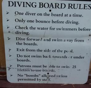
Photograph - Digital Image, Diving board rules, Greensborough Pool 1960s, 1960s
Rules for use of the diving board at Greensborough Pool, circa 1960s.Digital copy of colour photograph.greensborough swimming pool -
 Greensborough Historical Society
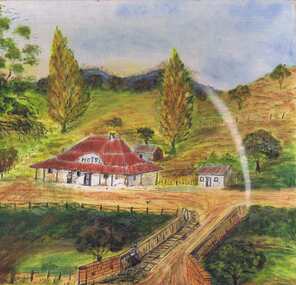
Painting, Lower Plenty Hotel c1940-1950, 1940-1950
Artists impression of the Lower Plenty Hotel mid-20th century. An original painting of the Lower Plenty Hotel.Mixed media on canvas board. Landscape with hotel in middle ground.Signed with initials "S.J." on front. On back: "From photo. Painted 1960-1970. LOWER PLENTY HOTEL c1940-1950. Sylvia Jones"lower plenty, lower plenty hotel, sylvia jones -
 Greensborough Historical Society
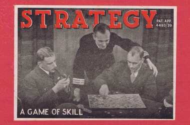
Game, Strategy: a game of skill, 1939c
Strategy is a board game involving army divisions, battleships and aircraft. The tactical object of the game is to steadily reduce your opponent's forces until you have numerical advantage.An Australian-made game possibly published during or just after World War 2.Board game in cardboard box. Includes game board, sheet of "Rules" and 29 playing 'pieces' [5 missing]war games, board games, strategy [game] -
 Greensborough Historical Society
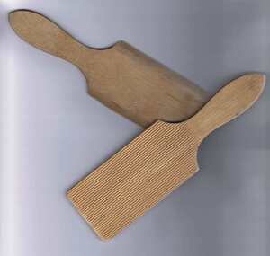
Butter Pats, Unknown, Pair of butter pats, 1920-1930
These wooden butter pats were used to shape butter into bricks; making butter ready for sale and use. The excess moisture would be squeezed out of the butter; which was then transferred to a wooden board. The butter maker would hold one of these pats in each hand and work the butter into shape. These wooden pats are thin; light and easy to hold. The inside face is serrated to grip the butter and squeeze out any further water. It was also used to make patterns on the finished butter. An original pair of butter pats. Given to a Greensborough local in 1975, but used by the previous owner and her mother.Wooden butter pats with handle. One side is ribbed, the other smooth.butter pats, butter making, nancy fowkes -
 Greensborough Historical Society
Photograph - Digital Image, RSL Honour Board, 1914-1918
Photograph of the Greensborough RSL Honour Board, listing the names of local men who enlisted in World War I.Digital copy of colour photograph.greensborough returned servicemens league, world war i, greensborough rsl -
 Greensborough Historical Society
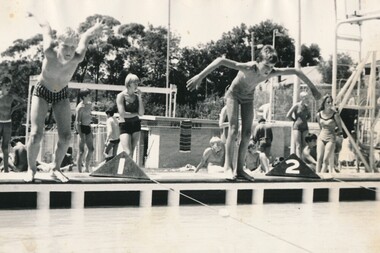
Photograph - Digital image, Swimming Sports Greensborough Pool 1960s, 1960s
Photograph of school swimming carnival held at Greensborough Pool circa 1960s. [Caption by Bruce McDowell: The boys on the edge of the pool are Neil McDowell (Left) and Lance Franklin. The blond girl behind them is Judy Banks, the blond boy sitting on the ground is Bruce Thomas and the girl leaning on the diving board is Denise Gaywood.]This Pool was demolished to make way for the Watermarc complex.Digital copy of black and white photograph.greensborough pool, watermarc -
 Greensborough Historical Society
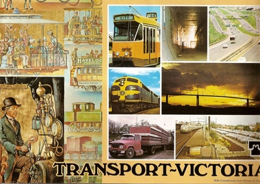
Book, Transport in Victoria, 1980s
Each of these booklets details the history, changes and upgrades to transport in Victoria in the early 1980s and explains the role af government authorities such as the Country Roads Board. Item 707c describes the Melbourne Freight Terminal between Spencer Street and Footscray Road.An historical look at the development of transport in Victoria.A collection of 3 booklets on transport in Victoria. Item 707a: 16 pages, colour illustrations. Item 707b: 20 pages, colour illustrations.Item 707c: 8 pages, black and white illustrations (20 x 14.5 cm). railways, transport, victoria, trams, roads -
 Greensborough Historical Society
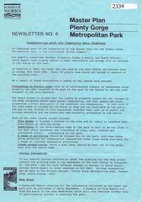
Newsletter, Melbourne & Metropolitan Board of Works, Master Plan Plenty Gorge Metropolitan Park, 1991_06
The Parks Division of the Board was responsible for the preparation of a Master Plan for the management of the Plenty Gorge Metropolitan Park, comprising privately owned land and land owned by the Board and councils.The creation of the park by the Victorian government, to be managed by the Board of Works, guaranteed public access to a large area of land adjacent to the Plenty River Gorge.2p. newsletter, black ink on blue paperNewsletter No. 6plenty gorge park, plenty river -
 Greensborough Historical Society
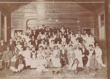
Photograph, Darge Flash photo, Plain and Fancy Dress Ball Rechabite Hall Greensborough 10.11.1905, 10/11/1905
A group of unidentified people at the Rechabite Hall in Greensborough 1905.Sepia photograph mounted on grey mounting board. "Plain & fancy dress ball Rechabite Hall Greensborough 10.11.05"rechabite hall greensborough, fancy dress ball -
 Greensborough Historical Society
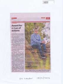
Newspaper clipping, Award for a man of actions, 18/12/2013
Parade College graduate Lucas Zugaro earned the Victorian Curriculum and Assessment Board's 2013 VCE Leadership Award for his social justice work during his senior school years.News clipping, black text, colour image.Source written on fron: DV Leader 18/12/2013parade college, lucas zugaro -
 Greensborough Historical Society
Newspaper Clipping, Get on board, 26/03/2014
Greensborough's Watermarc staff will wear board shorts to support 'Boardies Day' to raise funds for the Surf Life Saving Foundation.News clipping, black text, colour image. Front page and inside report.watermarc, boardies day, surf life saving foundation -
 Greensborough Historical Society
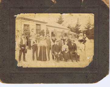
Photograph, Unknown, Greensborough Hotel, 1900c
Photograph of group outside the original Greensborough Hotel situated in Church Street Greensborough. The man in the rear right holding a child has been identified as William Rank. The Rank family came from Heidelberg and it was common practice to drive horse and carriage to Greensborough for a gathering or picnic.Sepia photograph mounted on brown board. Some damage to photo and mount.rank family, william rank -
 Greensborough Historical Society
Photograph - Digital image, Dennis Ward, Greensborough Primary School Gr2062 Honour Roll, 1914-1918
Greensborough Primary School Honour Board in situ in the original school building. This board honours those local men who served in World War I. (Photo taken in 2014)Digital copy of colour photograph.greensborough primary school, world war 1 -
 Greensborough Historical Society
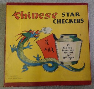
Game, Milton Bradley Company et al, Chinese Star Checkers, 1970_
Chinese Star Checkers is a game for 2 to 6 players. Instructions are included.Game in cardboard box. Timber board with painted star and holes for game pieces. Bag of game pieces (small coloured balls).board games, chinese checkers -
 Greensborough Historical Society
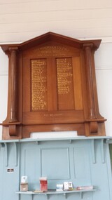
Photograph - Digital image, Greensborough Methodist Sunday School Honour Board, 1918c
The Greensborough Methodist Sunday School Honour Roll commemorates the young men from the area who fought in World War I.Digital copy of colour photo.world war 1 -
 Greensborough Historical Society
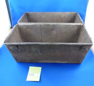
Bread Tin, Baker's bread tin, 1953_
Bread tin from Wright's Bakery; Main Street Greensborough. This bakery has now closed. Advertisement: Baker: must be a board hand. Apply Wright's Bakery. 96 Cape Street. Heidelberg. [The Age 14/10/1953, page 25]Metal baker's bread tin (double). Rusted.bread tins, wrights bakery greensborough -
 Greensborough Historical Society
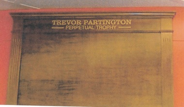
Photograph - Digital image, Trevor Partington Perpetual Trophy, 2000c
Perpetual Trophy board to honour Trevor Partington. Trevor was a keen sportsman, playing over 300 games of football for Greensborough, cricket, athletics, wood chopping and bowling.Digital copy of colour photograph.trevor partington, trevor partington perpetual trophy -
 Greensborough Historical Society
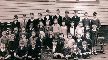
School Photograph - Digital Image, Briar Hill Primary School BH4341 1937, Grades 1-4, 1937_
Class photograph from Briar Hill Primary School, 1937, Grades 1-4. Student names are not identified.Digital copy of black and white group photograph.School and class identified on board in photograph.briar hill primary school, briar hill state school -
 Greensborough Historical Society
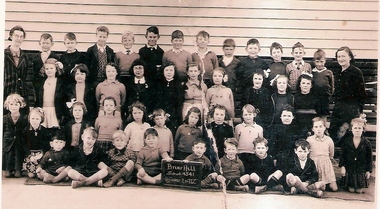
School Photograph - Digital Image, Briar Hill Primary School BH4341 1939 Grades 1-4, 1939_
Class photograph from Briar Hill Primary School, 1939, Grades 1-4.. Student names are not identified. Briar Hill State School was established in 1927.Digital copy of black and white group photograph.School and class identified on board in photograph.briar hill primary school, briar hill state school -
 Greensborough Historical Society
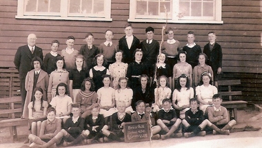
School Photograph - Digital Image, Briar Hill Primary School BH4341, 1942 Grades 5-8, 1942_
Class photograph from Briar Hill Primary School, 1942 Grades 5-8 . Student names are not identified.Digital copy of black and white group photograph.School and class identified on board in photograph.briar hill primary school, briar hill state school -
 Greensborough Historical Society
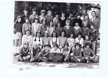
School Photograph - Digital Image, Greensborough Primary School Gr2062 1974 Grade S.D, 1974_
Class photograph from Greensborough Primary School No.2062. 1974 Grade S.D. Student names are not identified.Digital copy of black and white group photograph.School and class identified on board in photograph.greensborough primary school, greensborough state school -
 Greensborough Historical Society
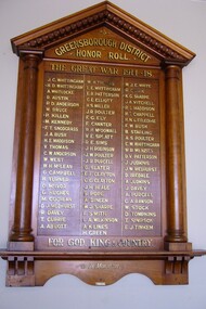
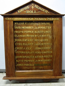
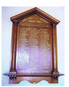
Photograph, Greensborough District Honour Roll, 1914-1918
This photograph of the Greensborough and District Honour Roll was taken on a visit to Greensborough RSL in 2012. [Caption by Bruce McDowell: The name of R H McDowall as shown on the board is incorrectly spelt - it should be R H McDowell - son of William McDowell & Susan Elizabeth McDowell (nee Poulter)]The Honour Board features the names of the Greensborough residents who fought in World War 1 and is located in Greensborough Primary School.A coloured photograph of a Great War 1914 - 1918 Honour Roll. Nilgreensborough, the great war, world war 1, military service