Showing 969 items
matching homesteads
-
 Port Fairy Historical Society Museum and Archives
Photograph
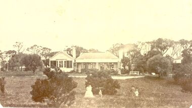
Leura Station homestead owned by Horace Flowers EsqBlack and white photograph of Leura station homestead with several women and children standing outsideleura, h flowers esq, house, station, farm, princes highway, building, horace -
 Buninyong & District Historical Society
Photograph - Black and White Photograph of Mount Boninyong Homestead 1991, View of croquet lawn Mount Boninyong Homestead 1991
The homestead was built in 1884 by Robert Scott in Scottish Baronial StyleThe original station of 16,000 acres was taken up in 1839 by Andrew Scott and Mrs. Scott was reputedly the first European woman in the districtView of croquet lawn at Mount Boninyong homestead part of the main house is visible in the backgroundearly settlement, mount buninyong, scott family -
 Warrnambool and District Historical Society Inc.
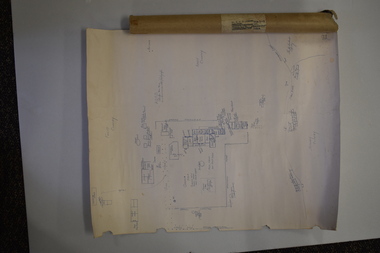
Document (Sketch Plan of Dunmore), Stan Baulch, 1972
This card has a sketch map showing the properties surrounding Dunmore on one side and a detailed sketch plan of Dunmore homestead in the early 1970s on the other side. The plan of Dunmore homestead shows interesting features such as the brick oven for bread making, the croquet lawn, the site of the aboriginal mia mias, the Turkish baths and the fowl house used later as a poison house. Francis and Ann Baulch were pioneer settlers in the Kirkstall area and their son Samuel worked at Dunmore in the Macarthur area before purchasing in the early 1870s the property he named Rose Park. In the 1890s he acquired property in the Dunmore estate and his son Stan Baulch gained a section of the Dunmore property after his father’s death. Stan Baulch named this Dunmore section, Rose Park, a property to the west of his father’s original Rose Park property. Stan Baulch was a long time member of the Warrnambool & District Historical Society and he contributed many local history articles and donated many local artefacts to the Society.This sketch plan is of interest as it tells us what the historic homestead of Dunmore in Western Victoria was like in the early 1970s. It will be useful for research. This is a sheet of white lightweight cardboard with a pencilled sketch on one side and a blue ink sketch plan of a house on the other side. The edges of the card have some torn sections. The card is enclosed in an oval cardboard cylinder (recycled and torn at the ends). Both the card and the cover have handwritten titles in ink. Dunmore Homestead & History by S. Baulch Dunmore Homestead drawn by Stan Baulch c.1972 dunmore property, western victoria, baulch family -
 Stawell Historical Society Inc
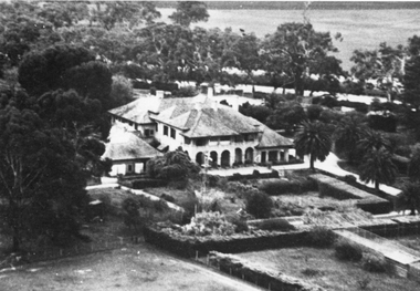
Photograph, “Warranooke” Homestead in Glenorchy 1867 -- aerial view
Aerial View of “Warranooke” Homestead. “Warranooke” Homestead built 1867 enlarged 1926. Shows extensive gardens at front. A very early property in our district Warranooke The main names associated with the property Ayrey - Darnell - Nicoll, later Campbell. Mrs. Campbell built Charles Ayrey's daughter. The Campbells built up the station buildings. The homestead was virtually rebuilt in brick, making it one of the largest and most elaborate in the East Wimmera. Warranooke homestead built 1867, enlarged 1926 destroyed by fire 13th Feb. 1979.Black and white aerial photograph of building showing landscape around the homestead. The photo is on a card with some gold decorations.glenorchy -
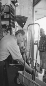 Lakes Entrance Historical Society
Photograph - Home Hardware, 1993
Home Hardware previously Homestead Hardware Esplanade through to Gray Street 1993Black and white photograph of Paul Hasler of Home Hardware previously Homestead Hardware Lakes Entrance Victoriabusinesses, hardware -
 Stawell Historical Society Inc
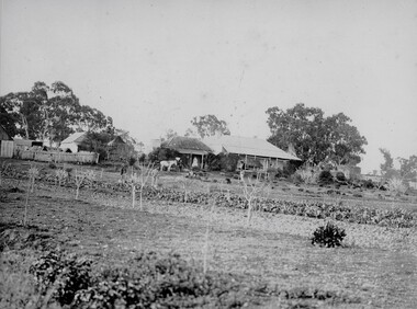
Photograph, Swinton” Homestead in Glenorchy with the large kitchen garden and Mr and Mrs Gray's 3 children
“Swinton” Homestead with large kitchen garden and worker. Mr. and Mrs. Gray with their three children and dog in the foreground. Photo of large vegetable garden in the foreground with three adults & three children with their dog. The homestead in the background. glenorchy -
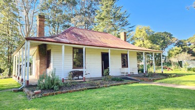
 Hume City Civic Collection
Photograph, 1937
When this photo was taken "Holly Green" as it was called then was owned by the Webb family. It was originally called "Emu Bottom" when the Evans family owned the property and re-named "Emu Bottom" when Hedly Elliot acquired it in the 1960s.A mounted black and white photograph of "Holly Green". There is a picket fence with a stone wall entrance on either side of a cyclone gate in the foreground. The fountain is on the LHS and a flowerbed on the RHS. The homestead is beyond the lawn. The mount is buff coloured with an inscription underneath the photo in gothic script.HOLLY GREEN / VICTORIA'S OLDEST HOMESTEAD AT THE AGE OF 101 YEARS / SUNBURY, 1937holly green, emu bottom, fences, fountains, sunbury, evans, george, webb, harry, stringer, esme, elliot, hedley, oldest house, house names, 1930s, george evans collection -
 Phillip Island and District Historical Society Inc.
Photograph, Bryant West
... homesteads ...One of a collection of over 400 photographs in an album commenced in 1960 and presented to the Phillip Island & Westernport Historical Society by the Shire of Phillip IslandPhotograph of "Glen Isla", the Anderson Homestead. An historic landmark.local history, photography, photographs, glen isla - homestead, glen isla, homesteads, historic landmarks, anderson's, john jenner, bryant west -
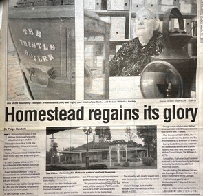 Melton City Libraries
Newspaper, Homestead regains its glory, 2003
Built in the 1850s, The Willows was purchased by Melton Shire Council in a dilapidated state in 1972. At a time of rapid change and growth, the restoration of the homestead, its transformation into the headquarters of the Melton & District Historical Society and the creation of The Willows Historical Park saw the community embrace its past while simultaneously looking to the future.History of the Willows Homestead Melton and Moorabool Leader articlelocal identities, local architecture, local significant groups -
 Phillip Island and District Historical Society Inc.
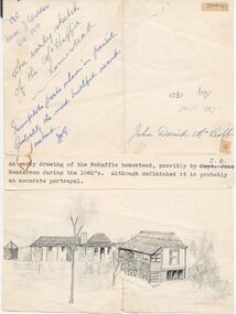
Drawing, 1860's
One of a collection of photographs and drawings donated by Mr J. W. Gliddon and used in his book "Phillip Island in Picture and Story"An early drawing of the McHaffie homestead, possibly by J. B. Henderson during the 1860's. Although unfinished it is probably an accurate portrayal."An early sketch of the McHaffie homestead" "Incomplete parts shown in pencil. Probably the most truthful record extant. J. W. G." "John David McHaffie."mchaffie homestead, phillip island, mr. j. w. gliddon -
 Melton City Libraries
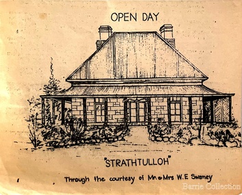
Drawing, Open Day at Strathtulloh, Unknown
"Strathtulloh, 1402-1600 Greigs Road, Melton South, is significant as an early property in Victoria, retaining different eras of pioneering dwellings, ranging from a ruin to a fine Colonial style homestead. The property has close historical association with the early settlement of the Melton district, and was owned by the Henty family in the 1840s. The Strathtulloh property was alienated by the Crown in 1840 to Charles James Garrard, who sold it in 1848 to Charles and Stephen Henty, whose sister Jane and her husband Samuel Bryan lived there in the late 1840s. In 1853 the property then passed to William Tulloh, after whom the homestead was named. A primitive bluestone ruin of near the Toolern Creek, built of vesicular bluestone and mud mortar, is of unknown origin. It has commonly been assumed to pre-date 1840, and to have belonged to the original holder of the Exford lease, Dr Watton or Port Phillip Association member Dr Cotterill. This is unlikely, as the 1841 census records Dr Watton, and everyone else in the district, as living in a ‘wood’ dwelling. It may instead have been the residence of Garrard, and the Bryans, in the 1840s and an early map names a site near here as ‘Bryan’s outstation’. It is assumed that the two-level stone building that became the kitchen is the earliest intact building on the site, and was the first homestead; it is likely to date to the 1840s or 1850s. The main homestead is a substantial villa constructed of random coursed bluestone, with a verandah facing three sides, attic bedrooms with dormer windows, a fan light over the front door, a hipped roof originally clad in slate, and a large cellar. Although demonstrating characteristics of pioneering construction, such as unworked log beams, pit sawn beams, hand-sawn lintels and colonial door locks, documentary evidence shows that it was built c.1869. The homestead has now been structurally repaired and decoratively restored; a sympathetic new semi-detached rear extension was added in the early years of the 21st century. The former kitchen building has also undergone minor repairs and alterations". Strathtulloh Homestead at 1402-1600 Greigs Road, Melton Southlocal architecture -
 Lakes Entrance Historical Society
Postcard, Whiters Camp Park, 1935c
The Homestead, L C P Furnished Apartments have become very popular (on back)Black and white small format postcard of the Homestead at Whiters Camp Park. A timber and fibro cement building in Californian bungalow style. Low pitched gable roof with built in veranda extensions. Homestead was the residence of the proprietor and family. Formal garden in foreground image. Lakes Entrance Victoriatourism, houses, resort -
 Camperdown & District Historical Society
Photograph - ''Wuurong'' homestead, Camperdown, c1870s
"'Wuurong'' homestead (originally 'Basin Banks') was built c1867 by Donald McNicol (1812-1903) shepherd, store owner and pastoralist. The property was leased c1870 by James Dawson (1806-1900) Guardian of the Aborigines, pastoralist and environmentalist. James Dawson renamed the property 'Wuurrong'. His daughter, Isabella Park Dawson (1842-1929), recorded the languages and customs of Western Victorian First Nations people and together with her father, published the book "Australian Aborigines" (1881).Black and white photograph of ''Wuurong'' homestead Front: An Early Photograph of "Wuurrong" Built By Donald McNicolcamperdown, cdhs, wuurong, djargurd wurrung, djargurdwurrung, cdhsfirstnations -
 Greensborough Historical Society
Photograph - Digital Image, Willis Vale site, 2014_
Photograph of the site of the 'Willis Vale' homestead, home of the Partington family. The derelict Willis Vale house was destroyed in 1964 when a fire originating from North Plenty Gorge - Kurrak Road - was lit by two teenage boys and made its way several kilometres down to Partington's Flat Greensborough.Digital copy of colour photograph."This house is where Willis Vale homestead was on Partingtons Flat"partington family, willis vale -
 Whitehorse Historical Society Inc.
Article, Have your say in Strathdon House, 2015
Whitehorse Council is inviting community feedback.Whitehorse Council is inviting community feedback on the draft report for conservation of the Strathdon Homestead and orchard in Springvale Road, Forest Hill.Whitehorse Council is inviting community feedback. strathdon homestead, springvale road, forest hill, city of whitehorse -
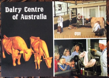 Phillip Island and District Historical Society Inc.
Postcard, Scancolor Australia et al, Dairy Centre and Rhylstone Park, Phillip Island, C. 1980s
Two coloured postcards. One of displays at the Dairy Centre, Newhaven. The second of Rhylston Park homestead, Cowes and it’s display of antiques and clocks.Dairy Museum, Phillip Island Road, Newhaven. Victoria 3925. Phone (059)567583 All Hours Rhylston Park Homestead Thompson Ave Cowes 3922 Phone (059)59522856. Rhylston Park(1886) features a display of over 380 antique clocks and watches. This unique collection is enhanced by the original homestead with beautiful lead light, ornate metal ceilings and marble fireplaces.the dairy centre, newhaven, homes, postcards -
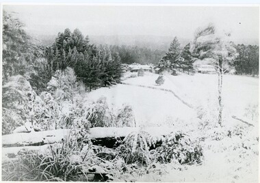 Mt Dandenong & District Historical Society Inc.
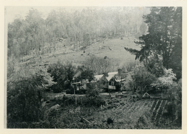
Photograph, A View Over Mountain Grange 1921, 1921
A view of Mountain Grange Homestead built by Thomas Hand with buildings and ground covered in snow. The photograph has historical information on the back handwritten by John Lundy-Clarke in 1976.1921 A view over “Mountain Grange” from the side of Mt Kalorama above where Grange Road is now. On the left of the homestead is the avenue of pine trees under which the annual Sunday School picnic was held. On the right is the giant pine that still stands (1976) and the great barn. The separate kitchen of the homestead can be clearly seen. mountain grange, snow, john lundy-clarke, thomas hand -
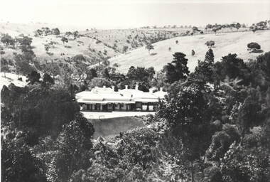 Sunbury Family History and Heritage Society Inc.
Photograph, 'Glenara' Homestead
'Glenara' is the homestead, which is situated in the Deep Creek valley at Bulla. It was the home of Walter Clark, who moved from NSW to Victoria in 1853 and purchased land on the banks of Deep Creek. Four years later in 1857 his homestead was completed. In the same year Bulla Racing Club held its first annual meet on the property. Later that year, Alister Clark purchased the homestead from the family estate and began developing an extensive rose garden on his property. Alister Clark developed varieties that are adaptable to Australia's climate such as the Lorraine Lee rose and his rose breeding achievements led him to international recognition as a rose breeder of note.A non-digital black and white photograph with a white border of large single story Italianite homestead in a creek valley and surrounded by lightly timbered hillsglenara homestead, bulla bulla, walter clark, alistair clark, roses, rose gardens, deep creek -
 Mt Dandenong & District Historical Society Inc.
Photograph, Home Of Francis Matthew Child, c1910
The homestead of Francis Matthew Child taken from the forest area downstream of Child Bros. Sawmill.Black and white photograph showing the homestead of Francis Matthew Child.This photograph has a detailed inscription on the back handwritten by John Lundy-Clarke.Francis Matthews home on Crown Allotment “E” taken from the forest edge of Harry Child miners lease on which he had his mill. Mill was upstream to the left. The trees in the background were on Hand’s selection “F” and beyond them was the summit of Mt Kalorama.homestead, francis matthew child, sawmill, child's sawmill -
 Lakes Entrance Historical Society
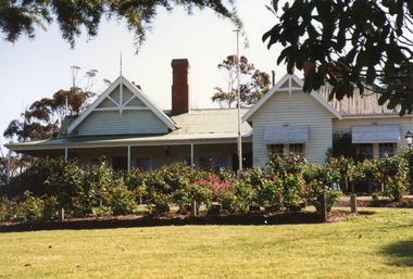
Photograph - Nyerimilang, 1999
Nyerimilang Homestead is in public ownership, managed by Parks Victoria.Colour photograph of Nyerimilang Homestead showing front view, including rose garden. Situated off Kalimna West Road, Nungurner, it is a large white painted timber homestead, corrugated iron roof of hips and gables, painted green, five internal brick chimneys. Situated above the lake with views of Fraser Island and Flannagan Island, outer barrier and distant ocean. Nungurner Victoriahistoric buildings, local history -
 Stawell Historical Society Inc
Photograph, "Allanvale" Home Station in Great Western 1866
Allanvale Home Station. Part of a collection of Photographs by Mr. O.G. Armstrong as commissioned by the Shire of Stawell for the Inter-colonial and Paris Exhibition in Melbourne in 1866. Allanvale was taken up about 1841 by John Allen, who was the son of George Allan of Allanvale, near Launceston in Van Diemen's Land. He selected 80,000 acres between present day Stawell and Ararat. The property was gradually reduced in size, with the first split occurring in the 1840s with the annexation of Concongella Selection due to a land dispute. J.S. Davidson was the occupier of Allanvale at the time this photograph was taken. The homestead pictured here was destroyed by fire at the end of the First World War and replaced by a new building around 1923. The present owners of Allanvale are the Kilpatrick family A note on the Allan family. On the 15th of March 1845, John Allen's 26 year old wife died at the birth of their third child, a daughter, who also died several weeks later. Elizabeth Allen had been a dear friend of Mrs Horatio Wills of neighbouring Lexington station. Eliza and her daughter were buried side by side in the garden of Lexington homestead. She was said to have been the first white woman to have died in the district. Homestead and stables on left with people on verandah and orchard in foreground.stawell great western -
 Ballarat Heritage Services
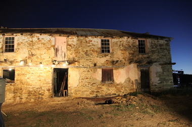
Digital photographs, L.J. Gervasoni, Gervasoni Homestead Yandoit Creek night, 2015
The drystone doublestorey homestead was made of local sandstone and was constructed by a partnership of four - Carlo Gervasoni, Luigi Gervasoni, Ambrogio Invernizzi, and Giuseppe Giupponi. The cellar was dug out first, and the stones that were removed was used to build the walls. The timber was cut by the dark of the moon when the sap was down. Digital images of the former Gervasoni homestead at Yandoit Creek, lit for the television show 'restoration Australia'. restoration, heritage, swiss italian, gervasoni, homestead, family, yandoit creek, yandoit -
 Phillip Island and District Historical Society Inc.
Photograph, 1978/9
The Homestead was probably built about 1872 when Samuel Amess became the owner of Churchill Island. A large weatherboard construction with bay windows and corrugated iron roofing.Coloured photograph showing the homestead on Churchill Island. Bay windowed rooms projecting forward on either side of the verandah. Not the sundial in the foreground.local history, photographs, buildings - historical, rural industry, coloured photograph, john cook, churchill island -
 Hume City Civic Collection
Photograph, Woodlands Homestead, c1858 - 59
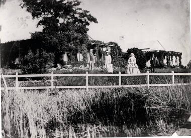
The photograph is of the Woodland Homestead at Bulla which was sited along the Moonee Ponds Creek. William Pomroy Greene and his wife Anne, emigrated from Scotland and arrived in the Port Phillip area in December 1842.. He acquired the Crown land at Gellibrand Hill in 1843 and built the prefabricated homestead which became known as Woodlands. The people in the photograph, taken about 1859 - 60, are L- R: Possibly Sir Willian Stawell, ?, little Anne Catherine Greene at 2 years, Rawdon Greene, Mrs. Greene and Smith ( a butler).The Greene family were one of the early European settlers to acquire land in the Bulla Bulla district. The Woodlands property is now a national park and the significant Gellibrand Hill is within the park.A black and white photograph of 3 men, a lady and a child standing in a garden in front of a homestead. A wooden post and rail fence is in the foregroundwoodlands homestead, greene family -
 Mt Dandenong & District Historical Society Inc.
Photograph
The photograph belonged to Frank Child and shows the homestead belonging to his grandparents Ted and Ethel Child situated on Childs Road at Kalorama. Francis Matthew (Frank) Child (1928 – 2020) was the son of Bernard Child (1907 – 1995). Bernard was the son of Ethel May Madden and an unknown father. When Ethel married Ted Child in 1908 Bernard was raised by Ted’s parents Francis and Martha Child. Bernard married Dulcie Paice (1904 – 1990) and they had one son, Frank Child, before they divorced in 1943.Small sepia photograph showing a woman entering the gateway to a homestead. The trees have lost their leaves and their are shrubs along the fence line. Two sheds can be seen to the right with a homestead roof to the left.Handwritten on reverse: Home of Ethel + Ted Child Childs Rd Kaloramafrank child, ted child, ethel child, childs road, kalorama, homestead -
Lakes Entrance Historical Society
Photograph - Strathfieldsaye Homestead, 1/12/1987 12:00:00 AM
Also another colour photographs taken at same time of Strathfieldsaye Homestead 05049.1 10 x 15 cmColour photograph showing the front verandah wisteria vine and garden at Strathfieldsaye Homestead taken up by William O'Dell Raymond in 1942 on Lake Wellington Gippsland Victoriaagriculture, houses -
 Phillip Island and District Historical Society Inc.
Photograph, Anderson Family Homestead, 1960
Glen Isla Homestead. Home of Robert Anderson.Close up of back entrance to Glen Isla Homestead. Figure of unidentified woman at back door. bush on right. Out-building semi attached to house, shed door open. Dog-leg path.local history, photography, photographs, slides, film, buildings, historic, glen isla homestead, phillip island, coloured photograph, mrs emma anderson jacobs -
Tatura Irrigation & Wartime Camps Museum
Photograph - Framed Photograph, Atherston Homestead
Photo of home built by John Donaldson around 1890. Atherston Homestead. Tatura homestead. John Donaldson. A Bountiful Harvest. Allen Staley Donaldson. Homestead with Garden. Harston. Heath Road. Black and white photo in silver coloured frame of front and side of house with veranda and front garden. Child on stepsHand written on border Atherston Homestead, 310 Heath road, Harsten, Tatura, around 1890. Built by John Donaldson. Ref a Bountiful Harvest - page 150. Allan Stanley Donaldson - child on steps. house, garden, child -
 Old Gippstown
Building - Bushy Park
13 August 1843 First application for the Bushy Park run appeared in the “Port Phillip Gazette”. It was taken up by Angus McMillan, who took up the Boisdale run across the Avon River at the same time, for his employer Lachlan Macalister. This house was built in 1848. March 1844 Licence to Bushy Park granted to McMillan. It consisted of 16,000 acres. Late 1840s Bushy Park homestead built for McMillan by Andrew Martin and Matt McCraw. High local historic significance as associated with major pioneer and a very old white settlement in Gippsland.A square shaped timber house, with a corrugated iron roof over shingles. It has a verandah that covers both the front and sides of the house. The house is contructed of redgum timber, and internally has four rooms.National Trust of Australia Plaque - Bushy Park Homestead - Class 'C'mcmillan, angus, old gippstown, west gippsland, gippsland, gippsland heritage park, goldfields, victorian era, moe, historical village, wellington shire, avon river, boisedale, briagolong, dargo, murdoch mackintosh, national trust, andrew martin and matt mccraw., latrobe valley, old gippstown heritage park, gunaikurnai, latrobe city council -
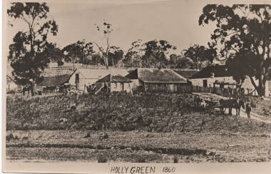 Sunbury Family History and Heritage Society Inc.
Photograph, 'Holly Green' 1860
... Homesteads ...The property in the photograph is 'Emu Bottom' possibly after George Evans leased it, as the caption across the image reads 'Holly Green' 1860.An old non-digital black and white photograph with a cream border of a rural property showing the homestead on the RHS and three out buildings and trees in the background. A man is standing with a horse and open dray on the lower RHS of the image.'emu bottom', holly green, george evans, sunbury, homesteads