Showing 1290 items
matching lands
-
 Orbost & District Historical Society
map/brochure, Discovering Marlo & The Snowy River Estuary, December 1988
In 1983 the Department of Conservation, Forests and Lands replaced the Department of Crown Lands and Survey, the Department of State Forests and the Ministry for Conservation. This brochure/map was used as tourist information in Orbost.This item is a useful research tool.A folded map/brochure titled "DISCOVERING MARLO & THE SNOWY RIVER ESTUARY". On the front is a photograph of Marlo and the title in yellow print. There is a locality map for access to Corringle beach and the brochure Includes a key to fishing sites and various tourist locations. On the back of the brochure are notes on fishing, wildlife and a boating guide, map brochure snowy-river marlo -
 Port Melbourne Historical & Preservation Society
Letter - Department of Lands and Survey re proclaimation of Beach Street, Sandridge, Department of Lands and Survey, 16 Mar 1861
Handwritten letter on blue foolscap laid paper, from Dept of Lands and Survey 16.3.1861, directing attention to proclamation in Government Gazette re Beech Street (sic) Sandridgelocal government - borough of sandridge, engineering - roads streets lanes and footpaths -
 Bendigo Historical Society Inc.
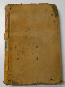
Document - LANDS OFFICE, CROWN LANDS SURVEYED AND SOLD, 1860/70
Document: buff hard cover journal, embossed on borders. On spine 'Lands and Survey' 'Index Book' and '03'. Contains list of parishes in front cover, indexed to page numbers which describes land surveyed and sold in parishes. Double page entries. 230 pages in book. LH page ' town lands, suburban lands, country lands, total lands surveyed, date of survey. RH page: date of sale, by auction, by selection, price per acre, total amount name of purchaser.Lands Officeland sales, lands office, land surveyed, land sold, bendigo, sandhurst -
 Wodonga & District Historical Society Inc
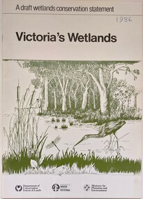
Book - Victoria's Wetlands, Dept. of Conservation, Forests & Lands, 1986
This publication was the result of an inquiry into the state of wetland environments in Victoria. It produced a draft strategy for conservation of threatened areas in the future.An 22 page book containing maps and illustrationsThis publication was the result of an inquiry into the state of wetland environments in Victoria. It produced a draft strategy for conservation of threatened areas in the future.wetland protection, wetlands victoria, water conservation -
 Glenelg Shire Council Cultural Collection
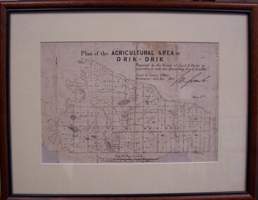
Map - Map of Drik-Drik, 1865
Displayed at History House.Print of map pasted onto board, mounted and framed under glass. Buff-coloured mount. Mahogany stained moulded wood frame, black inner frame.Front: Plan of the Agricultural Area of Drik-Drik L.2556/Prepared by the Board of Lands and Works in accordance with the "Amending Land Act 1865". Lands and Survey Office, Melbourne 11th May 1865. (printed, upper centre). Back: Duncan Hedditchmap, drik drik, plan, geography, cartography -
Clunes Museum
Document (Item), DEPARTMENT OF LANDS AND SURVEY, RENEWALS GARDEN LICENCE 5/
RECEIPT BOOK DEPARTMENT OF LANDS AND SURVEY. LICENCE TO ENTER UPON CROWN LANDS NOT EXCEEDING IN AREA ONE ACRE, AS SPECIFIED HEREUNDER, FOR PURPOSES OF GARDEN AND RESIDENCE. FEE PER ANNUM 5 / O (FIVE SHILLINGS) FIFTY CENTSlocal history, local government, council, licence, garden -
Port Melbourne Historical & Preservation Society
Plan, Department of Lands and Survey, The Township of Sandridge, 25 Nov 1860
Plan of the township of Sandridge lithographed at the department of Lands and Survey, Melbourne 5th November, 1860. Identical to 1859 version except for added rail line through Sandridge and onto Town Pierengineering - roads streets lanes and footpaths, municipal district of sandridge -
 Surrey Hills Historical Society Collection
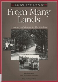
Book, Voices and stories from many lands: a century of change in Boroondara, 2001
Stories of the backgrounds of a cross-section of City of Boroondara residents focusing on how they came to live in Australia and in the City of Boroondara in particular. Many were based on oral histories. Commissioned by the City of Boroondara, the team behind "From Many Lands" also received a Local History Award, which allowed them to mount a small touring exhibition. Two Surrey Hills people contributed to the book: Margaret Grossman (nee Sarovich) and Zdzislawa (June) Wasylkowski; photo of Walter Ives also included. Sue Barnett interviewed June Wasylkowski; the interview is part of the Surrey Hills Historical Society collection. Both Margaret (Peg) and June were members of the Surrey Hills Historical Society. Martin Foot was a Council staff member at the time of publication.H 24.7 cm(ms) ruth mclean, (mrs) margaret grossman, (miss) margaret sarovich, (mrs) zdzislawa june wasylkowski, immigrants, oral history, boroondara, (mr) walter ives, sue barnett, june wasylkowski -
 Bendigo Historical Society Inc.
Document - LANDS OFFICE - CROWN LANDS SURVEYED AND SOLD - INDEX, 26.1.1857 - 1871
Document: hard cover journal, faded dark green cover with brown corners and spine. 193 pages filled out - LH page: Parish, town lands, suburban lands, country lands, total lands surveyed, date of survey RH page: date of sale, by auction, by selection, price per acre, total amount, name of purchaser. On spine ' 01, index book O'.Lands Officelands office, bendigo, sandhurst, crown lands sold, rural land. -
Victorian Aboriginal Corporation for Languages
Book, Peter Cabena et al, The lands manual : a finding guide to Victorian lands records 1836-1983, 1992
charts, extracts from original documentsvictorian history, archives, local history, crown lands, public lands, land tenure -
 Federation University Historical Collection
Plan, Department of Crown Lands and Survey, Melbourne, Buninyong County of Grant, 23/07/1929
The plan was photo-lithographed at the Departmen tof Lands and Survey, MelbourneA parish plan of Buninyong, including Robert Scott's Mt Buninyong Pre-emptive Right, Mt Buninyong Public Park, Thomas Learmonth's land, John Learmonth's land, Scotchan's, Yendon. The Buninyong POst Office is Allotment 1. Pisition of tracks in 1859 have been marked on the plan in red.buninyong, scotchman's, mt buninyong, robert scott, clarendon, lal lal creek, yendon, warrenheip, yarowee, enfield, thomas learmonth, john learmonth, archibald fisken, g. schloo, george innes, peter inglis, durham lead, j. fry, j. forrest, parkin lee, buninyong recreation reserve -
 Mont De Lancey
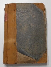
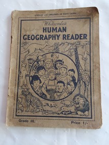
Book, Whitcombe & Tombs Limited, Whitcombe's Human Geography Reader Grade III - Animals and Children of Many Lands, 1939
Whitcombe's Human Geography Reader Grade III - Animals and Children of Many Lands is specially written to meet the requirements of the Social Studies (Geography) Course of Study in Victorian Elementary Schools. It is intended for the personal use of the pupil and has been written for juveniles. It aims to encourage world friendship with descriptions and pictures of the children from many lands. Many of the animals and birds of the world are illustrated and described. The topics are written in story form. Dramatization is encouraged as well as outdoor activities and the making of a pupil's geography picture book.A faded green paperback reader or textbook with black lettering on the front cover at the top for the title Whitcombe's Human Geography Reader. Grade III. A cost of 1/- is printed in the lower right hand corner. On the front cover is a black lined illustration inside a round shape of children in traditional costumes from different lands with many lined drawings of animals from around the world. The title page has the title and publisher details as well as a black and white photograph of two children sitting in a Dog-Cart in Summer. Throughout are black and white charts, maps, diagrams, photographs and illustrations. On the inside of the front cover is a Contents page and the back cover lists further Whitcombe's titles as well as on the outside of the back cover. Pp. 52.non-fictionWhitcombe's Human Geography Reader Grade III - Animals and Children of Many Lands is specially written to meet the requirements of the Social Studies (Geography) Course of Study in Victorian Elementary Schools. It is intended for the personal use of the pupil and has been written for juveniles. It aims to encourage world friendship with descriptions and pictures of the children from many lands. Many of the animals and birds of the world are illustrated and described. The topics are written in story form. Dramatization is encouraged as well as outdoor activities and the making of a pupil's geography picture book.handbooks, textbooks, geography, children's books -
Port Melbourne Historical & Preservation Society
Letter - Department of Lands and Survey re proclaimation for site of Town Hall, Sandridge, Department of Lands and Survey, 30 Dec 1861
Handwritten letter on blue foolscap laid paper, from Dept of Lands and Survey 30.12.1861 directing attention to proclamation in Government Gazette re site for Town Hall at Sandridge. Paper, watermarked with Britannia symbollocal government - borough of sandridge, port melbourne town hall -
 Mont De Lancey
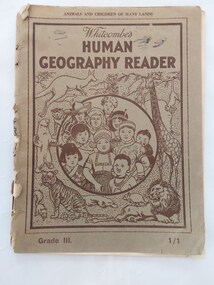
Book, Whitcombe & Tombs Limited, Whitcombe's Human Geography Reader Grade III - Animals and Children of Many Lands, No date is listed but it is possibly a reprint of the 1939 issue as it is exactly the same except for the price on the front
Whitcombe's Human Geography Reader Grade III - Animals and Children of Many Lands is specially written to meet the requirements of the Social Studies (Geography) Course of Study in Victorian Elementary Schools. It is intended for the personal use of the pupil and has been written for juveniles. It aims to encourage world friendship with descriptions and pictures of the children from many lands. Many of the animals and birds of the world are illustrated and described. The topics are written in story form. Dramatization is encouraged as well as outdoor activities and the making of a pupil's geography picture book.A faded green paperback reader or textbook with faded black lettering on the front cover at the top for the title Whitcombe's Human Geography Reader. Grade III. A cost of 1/1 is printed in the lower right hand corner. On the front cover is a black lined illustration inside a round shape of children in traditional costumes from different lands with many lined drawings of animals from around the world. The title page has the title and publisher details as well as a black and white photograph of two children sitting in a Dog-Cart in Summer. Throughout are black and white charts, maps, diagrams, photographs and illustrations. On the inside of the front cover is a Contents page and the back cover lists further Whitcombe's titles as well as on the outside of the back cover. Pp. 52.non-fictionWhitcombe's Human Geography Reader Grade III - Animals and Children of Many Lands is specially written to meet the requirements of the Social Studies (Geography) Course of Study in Victorian Elementary Schools. It is intended for the personal use of the pupil and has been written for juveniles. It aims to encourage world friendship with descriptions and pictures of the children from many lands. Many of the animals and birds of the world are illustrated and described. The topics are written in story form. Dramatization is encouraged as well as outdoor activities and the making of a pupil's geography picture book.children's books, handbooks, textbooks, geography, schools -
Clunes Museum
Administrative record - BOOK, DEPARTMENT OF LANDS AND SURVEY, LICENCE
RECEIPTS ISSUED BY DEPARTMENT OF LANDS AND SURVEY TO CUT AND TAKE AWAY WOOD. ISSUED EACH QUARTER. LOCALITY - ALL CROWN LANDS, NOT BEING IN STATE FORESTS OR RESERVES FOR ANY SPECIAL PURPOSE. GUM, STRINGYBARK, BOX, MESSMATE AND OTHER KINDS OF EUCALYPTUS TIMBER EXCEPTING RED GUM AND IRON BARK.BLUE CARDBOARD COVERED BOOK CONTAINING TIMBER LICENCES FOR ORDINARY WOOD, COSTING 5/- .1 ISSUED 1886 - 1887 RECEIPT NUMBERS 181901 - 181925 .2 ISSUED 1885 - 1886 RECEIPT NUMBERS 185276 - 185300 DETAILS OF NAMES OF PERSONS LICENCES ISSUED TO ATTACHED TO BACK OF BOOKSlocal history, receipt books, early citizens, wood licences -
Port Melbourne Historical & Preservation Society
Plan - Sandridge, Department of Lands and Survey, "The Township of Sandridge", 5 Nov 1860
Map of Sandridge, lithographed 1860, showing subdivisions on Evans Street, but no other development West of the railway Lihographed at the Department of lands and Survey, Melbourne 5th November 1860. Hand drawn annotations added at unknown date.Hand written "clay ground" 18 chains long, 7.5 chains broad, 26 chains from railwayengineering - roads streets lanes and footpaths, sandridge lagoon, transport - railways, town planning, local government - borough of sandridge -
Port Melbourne Historical & Preservation Society
Letter - Department of Lands and Survey re notification of crown grants for Sandridge municipal chambers and market site, Department of Lands and Survey, 20 Jun 1862
Handwritten letter on blue foolscap laid paper, from Dept of Lands and Survey 20.6.1862 notifying Town Clerk of two crown grants, for municpal chambers and for market site. Paper watermarked A.Cowan & Sons 1855Notations in pencil on back, upper leftlocal government - borough of sandridge, market reserve, port melbourne town hall -
Port Melbourne Historical & Preservation Society
Letter - Department of Lands and Survey re proclaimation for site of Sandridge municipal common, Department of Lands and Survey, 10 Oct 1863
Handwritten letter on blue foolscap laid paper, from Dept of Lands and Survey 10.10.1863, directing attention to proclamation in Government Gazette re site for Sandridge municipal common. Paper, watermarked TH Saunders 1862local government - borough of sandridge, port melbourne town hall -
 Whitehorse Historical Society Inc.
Map - Public Lands Office map, Public Lands Office, Melbourne, Village of Ballyshanassy, 1858, 10 April 1858
A map of the Village of Ballyshanassy by the Public Lands Office, Melbourne. Scale 12 chains equals 5 cmsballyshanassy, parish of nunawading -
Port Melbourne Historical & Preservation Society
Letter - Office of Lands & Survey re permission to build a boat on Sandridge Beach, Secretary for Lands, 22 Jun 1876
Photo\copies of letter and small map from Office of Lands & Survey, 22 June 1876. Re permission to lease land to build a boat on Sandridge Beach. Original letter sent to J.C. Lowrie of Stokes Street. Various copies stapled together.local government - borough of sandridge, j c lowrie, sandridge beach -
 Bendigo Historical Society Inc.
Document - LANDS OFFICE, CROWN LANDS SURVEYED AND SOLD SANDHURST DISTRICT, 1854 (?) onwards
Document: buff colour hard cover journal. Contains details of crown lands surveyed and sold. On LH page, town, suburban or country lands. RH page: auction, selection, price per acre, price and purchaser. Indexed by parish in front page. Two front pages cut out. On spine ' Index book' ' Lands and Survey' '06' 'E' ' Country' and 'Sales'Lands Officeplace, land sales, bendigo, lands office, land surveyed, land sold, sandhurst -
 Ballan Shire Historical Society
Map - Map. Bungal, Department of Lands and Survey, Bungal, County of Grant, 09/09/1926
A map of Bungal in the 1920's showing the allotments, and the size, with the names of the residents. It shows the roads and the Western and Eastern Moorarbool River, and the Whipstick State Forest.Cream coloured map of Bungal in the County of Grant, bounded by the the East Moorarbool River on the East, and the State Forest on the South. It is marked with the scale of chains and the number L.358. Lithographed at the Department of Lands and Survey. Melbourne by W. J. Butson on 9.9.1926. It shows the land allotments with names of owners.Coloured pen marks and circled numbers on various areas. Price 2 shillings marked on bottom right hand edge.bungal, kerrit bareet, egerton, lal lal, borhoneyghurk, bungeeltap, ballark, yaloak, gorong, moorarbool west -
 Bendigo Military Museum
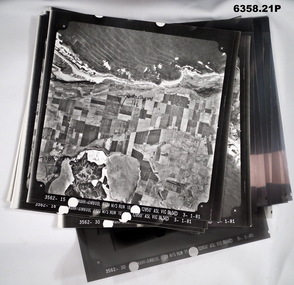
Photograph - Aerial Photography - Mohogany Ship Search Warrnambool Victoria, Victorian Lands Department, 3.1.1981
These Victorian Lands Dept Aerial Photographs were acquired by the Army Survey Regiment to help locate a Mohogany Ship wreck near Warrnambool Victoria as part of a unit Regimental Training ExerciseSeven Aerial photographic Prints and Film Negatives and positives of the same images. Images are Numbered 3562- 15,16,17,18,19, 29 and 30.royal australian survey corps, rasvy, fortuna, army survey regiment, army svy regt, asr -
 Bendigo Historical Society Inc.
Document - LANDS OFFICE: REPORT OF LAND SALES BY AUCTION 1881 - 1895, 1881 - 1895
Document: LANDS OFFICE: REPORT OF LAND SALES BY AUCTION 1881 - 1895 Green hard cover book with buff spine and corners. Contains reports of sale by public auctions of crown lands in Charlton, St. Arnaud, Avoca, Donald, Wedderburn, Wycheproof.Lands Officeland sales, auctions, lands office, land surveyed, land sold -
 Bayside Gallery - Bayside City Council Art & Heritage Collection
Photograph, Department of Crown Lands and Survey, Victoria, Melbourne Project: Brighton, 1976
The Department of Crown Lands and Survey (1857-1983) was responsible for the administration of survey and mapping and the sale, occupation and management of crown land throughout its existence. This aerial photograph shows parts of Brighton and was taken on 1 December 1976brighton, department of crown lands and survey, aerial photograph, bayside, port phillip bay, map, cartographic material, melbourne project 1976, brighton yacht club, middle brighton baths, north road, st kilda street, new street -
 Bayside Gallery - Bayside City Council Art & Heritage Collection
Photograph, Department of Crown Lands and Survey, Victoria, Melbourne Project: Brighton and Elwood, 1976
The Department of Crown Lands and Survey (1857-1983) was responsible for the administration of survey and mapping and the sale, occupation and management of crown land throughout its existence. This aerial photograph shows parts of Brighton and Elwood and was taken on 1 December 1976brighton, elwood, department of crown lands and survey, aerial photograph, elsternwick park, point ormond, north road, ormond esplanade, st kilda street, glen huntly road, bayside, port phillip bay, map, cartographic material, melbourne project 1976 -
 Bayside Gallery - Bayside City Council Art & Heritage Collection
Photograph, Department of Crown Lands and Survey, Victoria, Melbourne Project: Brighton and Hampton, 1976
The Department of Crown Lands and Survey (1857-1983) was responsible for the administration of survey and mapping and the sale, occupation and management of crown land throughout its existence. This aerial photograph shows parts of Brighton and Hampton and was taken on 1 December 1976. brighton, department of crown lands and survey, aerial photograph, bayside, port phillip bay, map, cartographic material, melbourne project 1976, brighton yacht club, middle brighton baths, hampton, green point, brighton beach, south road, the esplanade, hampton street -
 Bayside Gallery - Bayside City Council Art & Heritage Collection
Photograph, Department of Crown Lands and Survey, Victoria, Melbourne Project: Brighton, Hampton, Sandringham, 1976
The Department of Crown Lands and Survey (1857-1983) was responsible for the administration of survey and mapping and the sale, occupation and management of crown land throughout its existence. This aerial photograph shows parts of Brighton, Hampton and Sandringham and was taken on 1 December 1976brighton, department of crown lands and survey, aerial photograph, bayside, port phillip bay, map, cartographic material, hampton, sandringham, green point, sandringham yacht club, south road, beach road, hampton street, melbourne project 1976 -
 Bayside Gallery - Bayside City Council Art & Heritage Collection
Photograph, Department of Crown Lands and Survey, Victoria, Brighton, Elwood and Elsternwick, c. 1965-71
The Department of Crown Lands and Survey (1857-1983) was responsible for the administration of survey and mapping and the sale, occupation and management of crown land throughout its existence. This aerial photograph shows parts of Brighton, Elwood and Elsternwick and was taken circa 1965-71.brighton, department of crown lands and survey, aerial photograph, bayside, port phillip bay, map, cartographic material, elwood, elsternwick, elsternwick park, elwood tram depot, elwood pier, new street, glen huntly road, st kilda street, nepean highway -
 Bayside Gallery - Bayside City Council Art & Heritage Collection
Photograph, Department of Crown Lands and Survey, Victoria, Brighton, Brighton East and Bentleigh, c. 1965-71
The Department of Crown Lands and Survey (1857-1983) was responsible for the administration of survey and mapping and the sale, occupation and management of crown land throughout its existence. This aerial photograph shows parts of Brighton and Brighton East and was taken circa 1965-71.brighton, department of crown lands and survey, aerial photograph, bayside, port phillip bay, map, cartographic material, brighton east, dendy park, dendy street, centre road, nepean highway, south road, brighton golf course, golf