Showing 106 items
matching long beach
-
 Ballarat Heritage Services
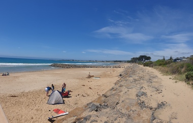
Photograph, Clare Gervasoni, Sea Wall at Apollo Bay, Victoria, 24/01/2022
In 2021, the Department of Environment, Land, Water and Planning (DELWP) constructed two new groynes and a section of rock seawall at Apollo Bay to help manage the impacts of coastal erosion. The new 70-meter-long rock groynes run perpendicular to the shoreline and be located just south of the Milford St revetment and to the south of Milford Creek. Sections of rock seawall will be constructed between the two Groynes with an aim to protect the dune, walking path, cypress trees and road from erosion. Colour photograph of a coastal scene at Apollo Bay, featuring new rock wall and groynes to protect the Great Ocean Road from erosion. apollo bay, beach, coast, groyne, rockwall, sea wall -
 Melbourne Legacy
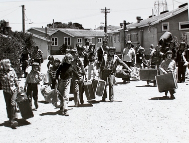
Photograph, Somers Camp, Not known
Photo taken of eager Junior Legatee’s on their arrival at Lord Somers Camp. The date is unknown. Summer camps were conducted at Somers Camp, Somers, Victoria, for many years for the children of deceased ex-servicemen. The camps started back in the early days of Legacy when the founder of Legacy, Stan Savige, had a beach side property in Balnarring (Palm Beach, Somers) that he allowed to be used for summer camps and outings by Legacy. Initially there were outings and picnics. In the 1930s permanent camp buildings were erected. There was an official handover of a long leasehold to Legacy and formal documents are in the archive.A record of the camps run by Melbourne Legacy for the children. Legacy arranged many outings and events for the junior legatees.Black and white photo of Junior Legatees arriving with their suitcases at Lord Somers Camp.junior legatee outing, somers camp, camp -
 Melbourne Legacy
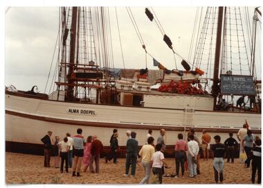
Photograph - Junior legatee outing, Alma Doepel
Three photos of the Historic Tall Ship 'Alma Doepel' at a beach and being viewed by a large group of children and adults. Presumably this was an outing for Junior Legatees to see the tall ship. The date is not known but Legacy has had a long relationship with the ship. The 1993 article in The Answer explains the ship offers 9 day voyages to approx 30 young people (15 to 18 year olds) and Legacy has sponsored 90 Junior Legatees in the first 3 years of the programme. 'Alma Doepel" is owned by Sail and Adventure Ltd, a Not for Profit organisation dedicated to the advancement of youth through sail training. The Alma Doepel is a three masted topsail schooner, Australian built and operated, with more than a hundred years of history behind her. She is currently under restoration in Docklands, Melbourne. Photos came from an envelope marked P8 Junior Legatee photographs, including the text "Photograph Alma Doepel". There was a program to send young legatees on trips on the Alma Doepel through the 1980s and 90s. The articles from the Answer show timetables and criteria for nomination of junior legatees to be selected on the trips. One of these articles mentions the war service of the Alma Doepel - the only ship with served in World War II that was still active in 1995.A record of a Legacy providing amazing experiences for the junior legatees that they might never have done because of the deaths of their fathers.Colour photo x 3 of Junior Legatees at Alma Doepel and an article from The Answer.Legacy P8 on reverse of each photo in blue penjunior legatee outing, alma doepel, answer -
 Ballarat Tramway Museum
Film - Video cassette tape and box, P. R. Wilson, Australian and NZ tramway Museums, 1994
VHS cassette and cardboard slip cover or box and labels on cassette and VHS tape. Made by Mr. P. Wilson of the United Kingdom during his visit during the winter of 1994 and a copy subsequently sent to the Museum in 1995. Part 1 - features a visit to the AETM St. Kilda Museum, including a trip to the beach and return in Ballarat 21 - 40 mins, an 8 minute trip on the Glenelg line, a visit to the Myer store - toy train and monorail (but not running), then a 10 min long session of a visit to Christchurch NZ. Part 2 - features a visit to Ballarat (28 mins. running time), featuring a trip on 14 with Dave O'Neil, and visit to the depot in particular 27, 1, 12 and 661 and video of the Tower truck at work. The final section is a visit to SPER at Loftus, including a trip to the National Park with 1971 and shots of Ballarat No. 12 on display. On cover labels " AETM, BTM, Adelaide, Glenelg, SPER, Ferrymead, (1994) by Mr. P.R. Wilson (UK)"ballarat, glenelg, aetm, ferrymead christchurch, sper -
 Bendigo Historical Society Inc.
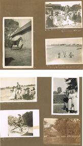
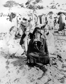
Photograph - HILDA HILL COLLECTION: BLACK AND WHITE PHOTOS, 1921-1922
Series of Black & White Images of Hill Family in the years 1921-1922. Total 7 Photos. Darkie the horse tethered to stable. Zita, Nora, Rita & Doreen one Zita is dressed in black with white scarf around her neck and wearing a dark coloured hat, other three are all dressed in white Nora has a dark hat and other two have broad brimmed hats, Rita and Doreen have black ribbons hanging from their necks, to the right are a man and lady seated on the ground and in dark clothing, a man with a pipe in his mouth and wearing a grey suit and hat in background, lady in black and lady in white looking in other directions, background has grandstand with gab le roof and fronted by a white picket fence and people sitting at tables and chairs, trees in right background, Queenscliff February 1921. Rita Nora Doreen lying face down on the beach, girl on left has dark hat on, background shows large shed and other housing with fences, 'Merry Mermaids' Queenscliff 1921.Four girls and one male, three girls dressed in white, one in dark colour, two have light coloured hats and two have dark colour hats, one girl dressed in dark colour, male is wearing white trousers and college coat with stripes, background shows skyline of the nearby city and beach buildings, two men occupy a seat right back ground and dressed in dark clothing, Queenscliff 1921. Cyril Fred Mollie Doreen in a conga line the boys in grey suits and the girls in white, one has circular bands on her skirt, hedge in near back ground, gable roofed building and trees further back,'Durvol' January 1922. Hal wearing dark coat and jodhpurs long boots sitting astride a bicycle, something balanced between the handlebars and on the top bar, paling fence with vine hanging overhead other plants in the corner of the yard, December 24 1921. Doreen riding in a billy cart and pulled by a large dog along a pathway, Doreen is wearing all white, background is bushes and hedge with large tree, Dog is dark colour, 'I'm coming' January 1921.Hilda Hill Personal Collectionaustralia, history, post war life -
Queenscliffe Maritime Museum
Domestic object - China crockery recovered from wreck of Light of the age
Subsequent to the wrecking of the Light of the Age marine concretions and corrosion products formed a cement capping over the cargo, stabilising and protecting it. The site of the Light of the Age was found by divers in late 1960s, and soon became a popular diving site. Huge amounts of intact crockery were removed from the wreck by boatloads of divers, including distinctive brown glazed teapots with legs (one diving author named it 'the Teapot Wreck' (Denmead, 1973: 78-82), 'Greek Key' patterned transferware, Cooper & Wood Portobello black glass three piece bottles, and sauce, preserve and condiment bottles often with contents (gooseberries, raspberries, olives) and seals intact. Larger items including a signal cannon and an anchor were removed from the site, while divers seeking souvenirs commonly used cold chisels to chip objects free of the concretion 'cap' which had stabilised and protected the remaining cargo for so long. In 1982 this situation was drastically changed when someone used explosives to further break concretions. However the charge was too powerful resulting in the site's complete destruction and the remaining items to become scattered and broken. Abraded and worn ceramic objects washed up on the beach are invariably collected by beachgoers, including fragments of crockery, figurines and animal figures used for 19th century household decoration and toys. The Light of the Age is archaeologically significant as the wreck of an international immigrant ship with an inward bound cargo. It is historically significant for its association with both the Black Ball and White Star Lines which carried thousands of immigrants to Australia. Built in 1855 and lost on 16 January 1868 now lies at Point Lonsdale Beach, half a mile west from Point Lonsdale, Port Phillip Heads.01- 1 shallow bowl, 02- 1 sweet bowl, 03- 1 willow pattern service dish, 04- 2 ladle cups [no handles], 05 06- 2 egg cups, 07- 2 bread and butter plates, 08- 1 condiment bowl lidWedgwood deep saucer; Pearl stone china, Ribbon, Wedgewood Willow Pattern service dish, Staffordshire Stone China, Fenton, No10shipwrecks, salvage, crockery, light of the age, clippers -
Ballarat Tramway Museum
Functional object - Destination Roll, NSW Department of Road Transport and tramways, "Newcastle"
Destination roll use din a Newcastle tram - on linen, black background with various colours and white letters. Each destination 10" high. 6 joins in roll, each approx. 800 to 900 long section. Letters in caps. Destinations shown are: West Wal'send Wallsend and Platsburg New Lambton Lambton Broadmeadow Adamstown Waratah Merewether B'H (Beach) Newcastle Tighe's Hill Mayfield Glebe Boreas Road Special Depot Sport Grd Show Grd Racecourse Speedway Telford St Hamilton Depottram, trams, newcastle, destination roll -
 Surrey Hills Historical Society Collection
Photograph, Stalker family beach picnic, 1930s
Associated with the Stalker family of Surrey Hills. Betty Neil Smith (Stalker) was born in 1919 in Balwyn (Surrey Hills). She was one of 4 daughters of Alexander MacLaren Stalker (1885-1970/1973) and Charlotte Eleanor Hayward (1884-1953) who were married in 1911. Her sisters were Ruth McLaren Stalker (1913, Surrey Hills), Joan Winnock Stalker (1917, Surrey Hills) and Beatrice Mary Stalker(1919). Their mother Charlotte Hayward was a teacher prior to her marriage. Their father Alexander, an accountant, lived in Wattle Valley Road, Canterbury in 1910. From 1912-1931 they are listed at ‘Benwerrin’, (44) Wandsworth Road, Surrey Hills. This was later the home of Beatrice Mary and Howard Everard. Betty, Ruth and Joan later lived at 9/48 Wandsworth Road. it is assumed that the photo is of the Stalker girls and given their parents' later residence at Brighton, this may have been taken at Brighton beach. This photo documents part of the social history of a family with a long and strong association with Surrey Hills. The backdrop of the typical bathing boxes used for changing into swimsuits, for lunch and for storing sports and beach gear, documents beach recreation and culture of the 1930s. For many years in the late nineteenth century, Brighton was Melbourne's favourite seaside destination. The now iconic bathing boxes were a response to Victorian ideas of morality and sea bathing. There are 82 Brighton bathing boxes, which protected by a heritage overlay because of their uniform scale and proportion, building materials, sentry order alignment. All retain their classic Victorian architectural features with timber framing, weatherboards and corrugated iron roofs. They remain as they did over one hundred years ago, as licensed bathing boxes. Service amenities such as electricity or water were never connected.A black and white photograph of many people enjoying the beach. There are bathing boxes in the background and some ti-tree beyond that.uniforms, clothing and dress, bathing boxes, stalker family -
 Surrey Hills Historical Society Collection
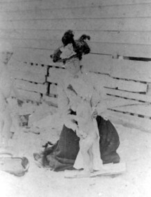
Photograph, Mrs Blanche Cornell
Mrs Blanche Cornell, wife of Frank Cornell, at the beach with 2 of her children, ? c1905 Frank Cornell was first listed in Surrey Hills in 1906 at (6) Lorne Parade. In 1908 the listing gives his occupation as a clerk. He was born in 1869 in Richmond, Victoria and died 15 April 1917 in Surrey Hills. Blanche Annie Parsons Cornell (nee Bracher) was born in 1869 in Hokitika, New Zealand; she died on 21 January 1940. Children were: Gilbert Frank Cornell (b1894, Hawthorn; d1908, at Frankston beach, an accidental drowning) Ruth Amelia Cornell (b 1899, Kew; d 29 May 1977, Kew) Lorna Amy Cornell (b 1906, Surrey Hills; d unknown) Patience Blanche Cornell (b1907, Surrey Hills; d unknown. Frank and wife Blanche are buried in Box Hill Cemetery - CE-*-1058. Ruth Amelia married David Ellis, c1922 in Surrey Hills. David was a dentist who practised in Surrey Hills for many years. Patience (Pat) Blanche married Norman Henry Brewer (1893–1975) in 1931 in Surrey Hills. Given the children's dates of birth, it is likely that it is Gilbert and Ruth in the photo. A black and white photograph of a lady dressed in an ankle length skirt, long sleeved blouse and wearing a hat. She is sitting on the beach and drying off one small girl. There is another small girl or boy to the left of the lady.clothing and dress, 1908, (mrs) blanche cornell, beach, (mrs) blanche annie parsons cornell, (miss) blanche annie parsons bracher, box hill cemetery -
 Surrey Hills Historical Society Collection
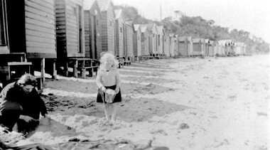
Photograph, Beatrice Mary Stalker, later Mrs Howard Breedon Everard, at the beach, 1930s
Mary Stalker’s engagement notice in The Argus in July 1947 indicates that she was the youngest daughter of Mr & Mrs A M Stalker of Montlare [Monclair] Avenue, North Brighton. It announces her engagement to ”Cr Howard Breedon Everard JP Ev-Ron, Woori Yallock, Youngest son of Hon WH Everard Wellington St Kew and the late Mrs Everard.” Beatrice Mary Stalker was born in 1919. Her parents were Alexander MacLaren Stalker (1885-1970/1973) and Charlotte Eleanor Hayward (1884-1953) who were married in 1911. Her sisters were Joan Winnock Stalker, Betty Neil Stalker and Ruth McLaren Stalker. Charlotte was a teacher prior to her marriage. Alexander, an accountant, lived in Wattle Valley Road, Canterbury in 1910. From 1912-1931 they are listed at ‘Benwerrin’, Wandsworth Road, Surrey Hills. Mary Stalker married in 1949 and by 1954 she and Howard were living at 44 Wandsworth Road, Surrey Hills, which was their home for decades. Howard was born in 1914 and died in October 2010: "EVERARD. - Howard Breedon. In loving memory of Howard, who lived life to the full to the very end of his 96 years. Greatly loved and honoured by Mary, Rosemary, David, Elizabeth, John and extended families." Beatrice Mary Everard died on 25 September 2019, aged 93. it is assumed that the woman in the photo is Mary's mother, Charlotte Eleanor Stalker (nee Hayward). The photo taken at the beach in 1930's may have been at Brighton, given the family’s later association with the suburb. This photo documents part of the social history of a family with a long and strong association with Surrey Hills. The backdrop of the typical bathing boxes used for changing into swimsuits, for lunch and for storing sports and beach gear, documents beach recreation and culture of the 1930s. Given the family's later residence in Brighton, this may well have been taken at Brighton Beach. For many years in the late nineteenth century, Brighton was Melbourne's favourite seaside destination. The now iconic bathing boxes were a response to Victorian ideas of morality and sea bathing. There are 82 Brighton bathing boxes, which protected by a heritage overlay because of their uniform scale and proportion, building materials, sentry order alignment. All retain their classic Victorian architectural features with timber framing, weatherboards and corrugated iron roofs. They remain as they did over one hundred years ago, as licensed bathing boxes. Service amenities such as electricity or water were never connected.A black and white photograph of a lady and little girl on the beach. There is a row of bathing boxes behind them.(miss) mary stalker, bathing boxes, (mrs) mary everard, (miss beatrice mary stalker, (mrs) beatrice mary everard, (mrs) charlotte eleanor stalker, (miss) charlotte eleanor hayward -
 Vision Australia
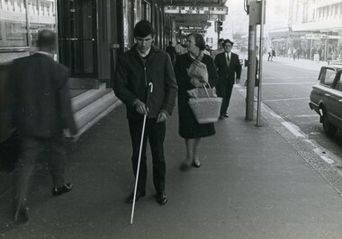
Photograph - Image, Kevin Stapleton and Wally Urgacz using their white canes, 1969
RBS client Kevin Stapleton uses a white cane as he descends church steps, crosses a road and walks along the footpath. Another RBS client, Wally Urgacz, walks behind Kevin as he crosses the road in the Sydney CBD. Wally Urgacz steps off the Bondi Beach bus and up a flight of stone stairs using his Hoover long cane, under the purview of Margaret Rihr.5 x B/W photographs of men using a white caneMobility - historicalroyal blind society of nsw, white cane day, kevin stapleton, wally urgacz, margaret rihr -
 Melbourne Legacy
Document - Speech, Sydney Legacy Bulletin Address 'The Beginnings of Legacy' given by Legatee Kemsley
An article from the Sydney Legacy Bulletin on an address by Legatee Alfred (Kem.) Kemsley, a long serving Legatee on the 'Beginnings of Legacy'. A detailed first hand account of the early history of Legacy. Legatee Kemsley mentions a village in France in June 1918 which was the HQ of Australian Corps, with General Birdwood, General White and General Monash, and that Monash had a role in setting up Legacy. He mentions a picnic at a beach with widows and children in March 1925 as the start of work with them. Legatee Kemsley was president of Melbourne Legacy in 1932. The article was part of an album of past presidents and prominent legatees from 1965 to 1989. The folder included biographical details and obituaries, eulogies and death notices of prominent Legatees. The items have been catalogued separately.A record of the beginnings of Legacy from Legatee Kem Kemsley. The information was collected to record the lives of prominent legatees in a folder.Typed copy of 2 pages from the Sydney Legacy Bulletin about an address made by Legatee Kemsley on 12 May 1983 and published 7 July 1983.history, speech, kem kemsley, past presidents -
 Woolamai Beach Surf Life Saving Club
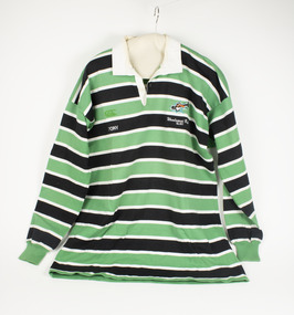
Uniform - Top Long Sleeve
... Woolamai Beach Surf Life Saving Club Woolamai Beach Road ...Long sleeve Top Green Black and White StripesClub Logo Woolamai Beach S.L.S.C. Tony -
 Warrnambool and District Historical Society Inc.
Booklet - The Ideal City Warrnambool On the Sea, 1944-1948
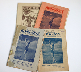
These booklets were issued in 1944 to 1948 by the Warrnambool Progress and Tourist Association(established in 1927). Warrnambool was the winner of the Sun News Pictorial Quest in 1928, the ‘Ideal City’ and used this title to promote the city. There had been several Tourist Associations in Warrnambool prior to 1927 and all of them promoted Warrnambool as a health resort and an ideal holiday destination with the Sea Baths in Gilles Street and the beach close by. These guides were produced during and immediately post World War Two with rationing of petrol and other goods and most people in Victoria would not have been contemplating long and expensive holidays so Warrnambool with its rail service and beach facilities would have been seen as a possible holiday destination. The booklets contain information on the tourist attractions of Warrnambool and district, black and white photographs of buildings, events and scenic spots and advertisements for local businesses. Many of the advertisements also contain photographs of business premises.These booklets are of interest as they contain photographs of Warrnambool in the mid to late 1940's and advertisements for many business operating at that time.[.1] 56 page booklet. The apricot cover has red printing and a picture of a young woman holding a beach ball aloft on the front. The white pages have black printing & blue coloured photographs. The last page is pink. [.2] 54 page stapled booklet. The pale blue cover has dark blue printing and a picture of a young woman holding a beach ball aloft on the front. There are three pink pages at the front. The remainder are white with black printing. This booklet contains a handwritten letter to the Warrnambool City Council and a yellow page typed reply acknowledging the donation. [.3] 48 page originally stapled booklet now held together with white cotton. The beige cover has dark blue printing and a picture of a young woman holding a beach ball aloft on the front. Name written in biro on front cover. There are blue and pink pages which contain photographs and an apricot coloured fold out map. [.4] 50 page booklet with rounded corners. The beige cover has brown printing and a drawing of a tennis player and golfer waving to two ladies in bathing costumes on the beach. There are sail boats, a mountain, clouds and a gum tree in the background. There are some coloured pages. [.1] The Ideal City WARRNAMBOOL ON THE SEA Victoria Australia Tourist Guide Where to Go! What to See! To Advance Warrnambool - "THE IDEAL CITY" Victoria's Premier Health and Holiday Resort - Price 6d. [.2] The Ideal City WARRNAMBOOL ON THE SEA Victoria Australia Tourist Guide Where to Go! What to See! To Advance Warrnambool - "THE IDEAL CITY" Victoria's Premier Health and Holiday Resort - Price 1/- [.3] The Ideal City WARRNAMBOOL ON THE SEA Victoria Australia Tourist Guide Where to Go! What to See! To Advance Warrnambool - "THE IDEAL CITY" Victoria's Premier Health and Holiday Resort - Price 1/6 Handwritten in biro Terry O'Sullivan - WCC 20/2/06 [.4] The Ideal City WARRNAMBOOL Victoria Australia ON THE SEA Happy Holiday Health Resort Surfing Boating Shooting Tourist Guide Where to Go! What to See! To Advance Warrnambool - "THE IDEAL CITY" Victoria's Premier Health and Holiday Resort - Price 1/6 Handwritten in biro 1948 warrnambool, ideal city, warrnambool tourist guide, warrnambool progress and tourist association, warrnambool tourism, warrnambool business advertisements -
 Lakes Entrance Historical Society
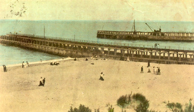
Photograph - Entrance Beach, 1905c
... on beach, ladies in long skirts, men in suits. Lakes Entrance... Lakes. People on beach, ladies in long skirts, men in suits ...Colour photograph showing newly constructed piers at entrance from ocean Bass Strait into Gippsland Lakes. People on beach, ladies in long skirts, men in suits. Lakes Entrance VictoriaLakes Entrance 1906 (E Bowen, Stationer, Sale) (on back)beaches, piers, ocean, machinery -
 Lakes Entrance Historical Society
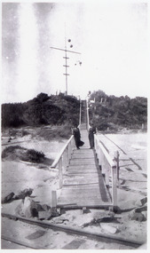
Photograph - Flagstaff, 1910c
Black and white photograph showing flagstaff and signal baskets on dunes, two women in long dresses on boardwalk, tram track on beach in front of unfinished boardwalk, vegetation on dunes. Lakes Entrance Victorianavigation, boardwalk -
 Darebin Parklands Association
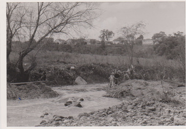
Ford in Darebin Creek May 1974, Darebin Parklands Association, 1974
... Annotated on back [showing pebbly "beach" now no longer there]...Annotated on back [showing pebbly "beach" now no longer ...B&W photograph. At place where concrete bridge is now located. This item and all other Darebin Parklands Association archival material is now held by State Library Victoria (Accession No: YMS 13746). Please contact State Library Victoria if access is required.Annotated on back [showing pebbly "beach" now no longer there] -
 Lakes Entrance Historical Society
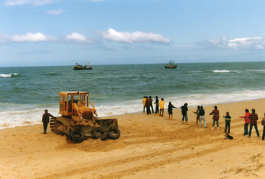
Photograph - Posidon, 1985
Colour photograph showing bulldozer and rescuers on beach west of Western pier, attempting to re float the Posidon. Two fishing vessels standing by at sea, line of people holding long rope. Lakes Entrance Victoriafishing industry, ships and shipping, shipwrecks, ocean rescue -
 Melbourne Tram Museum
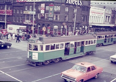
Slide - Set of 6, Keith Caldwell, March 1967?
Set of six Agfa colour blue white plastic mount slides, photo by Keith Caldwell of trams passing the intersection of Flinders and Swanston St. Slides undated - c1967/68, possibly 3/68, aligns with similar scene and time on Reg Item 4315 .1 - W4 670 crossing Flinders St with both the driver and conductor in the view. Has destination of Hanna St. .2 - L102 crossing route 61 to South Caulfield Junction. Has adverts for Tolley's Brandy and a fast courier. In the background is SW6 940 (University 2A) and W2 389? (East Malvern, route 4D) .3 - W3 668 to South Melbourne Beach, route 1 .4 - W3 669, route 1 to South Melbourne Beach, has advert for White Crow sauce. .5 - W2 627, North Balwyn with other trams at the Swanston St stop, including a SW6 on route 64 .6 - a long line up of up to 9 trams northbound at the Swanston St stop outside Flinders St Station, led by SW6 917 (University, route 64) with adverts Suptuned, Sony and "take my advice" featuring an owl. Following is another SW6, 913? with adverts for Tiger Paw, also a route 64. In the background is the Flinders St station awing with a Craven Filer cigarette advert.. Photos have Young and Jackson, the Classic Restaurant Coffee lounge bar in the view, Coles,.1 - "BXBU" and on .3, .1 also has W4" in ink.trams, tramways, flinders st, swanston st, w4 class, w3 class, l class, sw6 class, w2 class, hanna st, south caulfield, university, route 2a, route 4d, east malvern, st kilda beach, route 1, route 64, north balwyn, tram 670, tram 102, tram 668, tram 669, tram 627, tram 913 -
 Melbourne Tram Museum
Postcard, Railmac, SW5 781 turning from Brunswick St into Victoria Parade, 1995
Postcard - full colour - of tram SW5 781 turning from Brunswick St into Victoria Parade, 26/11/1990 going to St Kilda Beach. Has adverts for been (its going to be a long hot summer) and Christmas Cards on recycled paper. Has details of the tram type on the rear. Photo by Steve McNicol. Divided back, published by Railmac number S059 RMtrams, tramways, sw5 class, victoria parade, tram 781 -
 Melbourne Tram Museum
Photograph - Sorrento tram steam locomotive, c1910
Photograph Shows one of the Baldwin-built 0-4-0 saddle tank locomotives at the Sorrento beach terminus. The smokestack has been fitted with a diamond spark arrestor. Standing alongside the locomotive is a number of men including one with a long beard, wearing a top hatYields information about the Sorrento steam tram.Black and White photograph - with an "A crown M" logo and the words "Crown Copyright Reserved" printed on the rear of the paper.In ink "Front Beach Sorrento", with K J Magor and Peter Duckett stamps.sorrento, steam trams, postcards -
 Eltham District Historical Society Inc
Photograph, Looking north across the Fitzsimons Lane Bridge over Yarra River between Eltham and Templestowe, c.1985, 1985c
Turnoff to Candlebark Park on right. The bridge over the Yarra River was initially opened September 22nd, 1961. Newspaper reports at the time of opening stated it linked Bolton Street, Eltham, with Fitzsimons Lane, Templestowe. In 1955 the Country Roads Board (CRB) produced survey plans that showed proposed land acquisition for the future bridge and road approaches. The 1955 plan shows that it was proposed to connect Fitzsimons Lane with Bolton Street in Eltham by a diagonal road across the river. The road connection would then continue along Bolton Street to Main Road. Prior to construction of the bridge the CRB modified the proposal significantly so that there was a new road parallel with Bolton Street and then curving to join Main Road at what was then its intersection with Old Eltham Road. This involved significantly more land acquisition and altered the pattern of land subdivision through this corridor. Initially the new road was just a single two-way carriageway as it would have required a significant widening of the cutting on the Shire of Eltham side of the river. The road was officially un-named but was known locally as the Eltham-Templestowe Road. The 1966 Melway street directory and other 1960s editions also listed the road as the Eltham-Templestowe Road. In December 1970, Eltham Shire Council, in pursuance of the provisions of the Local Government Act, named it Templestowe Road. The road was renamed Fitzsimons Lane around 1984 in conformity with the section south of the river. In 1991 a new bridge was built to the west of the original bridge. Fitzsimons Lane was widened to four traffic lanes although on the Eltham side this was done within the limits of the existing cutting. NEW BRIDGE STARTS THEM EXPLORING Without any fanfares, Country Roads Board workmen on Friday afternoon put the finishing touches to the approaches, removed the barricades, and let the traffic roll over the new Yarra bridge linking Bolton Street, Eltham, with Fitzsimons Lane, Templestowe. Over the week-end many “bridge watchers” who were making one of their periodic inspections of the progress on the new bridge found to their surprise that they could drive over it, so that people who had gone for a run out to Eltham suddenly found themselves wandering through Templestowe and Doncaster. By Monday the word of the bridge’s opening had got around sufficiently for many regular travellers to the city from Eltham and beyond to vary the monotony by going to town via Templestowe and Kew instead of through Heidelberg. They were surprised at the distances – about 3 ½ miles from Eltham to Templestowe, 6 miles from Eltham Shire hall to the Lower Heidelberg Road-Banksia Street intersection. NEW NEIGHBOURS For people on both sides of the river, the new bridge has turned distant friends into near neighbours. A Greensborough man on Sunday took 35 minutes to reach the home of a friend in East Doncaster, but the return trip over the new bridge took only 17 minutes. It will be some time yet before most people work out the possibilities in shorter and quicker trips form the north-eastern areas to the eastern and south-eastern suburbs. The coming of the warmer months will soon teach many, though the short cuts to Peninsular beaches and eastern suburban drive-ins. And before very long it is likely there will be a Tramways bus running from Templestowe to Eltham station. NEW BRIDGE STARTS THEM EXPLORING (1961, September 27). The Diamond Valley News (News clipping held in SEA_74-1_047) The previously un-named road between Main Road and Yarra River, Eltham South, east of Bolton Street was named Templestowe Road, December 15, 1970 NAMING OF STREETS AND ROADS. (1970, December 15). The Diamond Valley News (News clipping held in SEA_74-2_022)Colour photographinfrastructure, shire of eltham infrastructure, bridge, fitzsimons lane bridge, yarra river, candlebark park, red nose day -
 Eltham District Historical Society Inc
Photograph, Fitzsimons Lane Bridge over Yarra River between Eltham and Templestowe
The bridge over the Yarra River was initially opened September 22nd, 1961. Newspaper reports at the time of opening stated it linked Bolton Street, Eltham, with Fitzsimons Lane, Templestowe. In 1955 the Country Roads Board (CRB) produced survey plans that showed proposed land acquisition for the future bridge and road approaches. The 1955 plan shows that it was proposed to connect Fitzsimons Lane with Bolton Street in Eltham by a diagonal road across the river. The road connection would then continue along Bolton Street to Main Road. Prior to construction of the bridge the CRB modified the proposal significantly so that there was a new road parallel with Bolton Street and then curving to join Main Road at what was then its intersection with Old Eltham Road. This involved significantly more land acquisition and altered the pattern of land subdivision through this corridor. Initially the new road was just a single two-way carriageway as it would have required a significant widening of the cutting on the Shire of Eltham side of the river. The road was officially un-named but was known locally as the Eltham-Templestowe Road. The 1966 Melway street directory and other 1960s editions also listed the road as the Eltham-Templestowe Road. In December 1970, Eltham Shire Council, in pursuance of the provisions of the Local Government Act, named it Templestowe Road. The road was renamed Fitzsimons Lane around 1984 in conformity with the section south of the river. In 1991 a new bridge was built to the west of the original bridge. Fitzsimons Lane was widened to four traffic lanes although on the Eltham side this was done within the limits of the existing cutting. NEW BRIDGE STARTS THEM EXPLORING Without any fanfares, Country Roads Board workmen on Friday afternoon put the finishing touches to the approaches, removed the barricades, and let the traffic roll over the new Yarra bridge linking Bolton Street, Eltham, with Fitzsimons Lane, Templestowe. Over the week-end many “bridge watchers” who were making one of their periodic inspections of the progress on the new bridge found to their surprise that they could drive over it, so that people who had gone for a run out to Eltham suddenly found themselves wandering through Templestowe and Doncaster. By Monday the word of the bridge’s opening had got around sufficiently for many regular travellers to the city from Eltham and beyond to vary the monotony by going to town via Templestowe and Kew instead of through Heidelberg. They were surprised at the distances – about 3 ½ miles from Eltham to Templestowe, 6 miles from Eltham Shire hall to the Lower Heidelberg Road-Banksia Street intersection. NEW NEIGHBOURS For people on both sides of the river, the new bridge has turned distant friends into near neighbours. A Greensborough man on Sunday took 35 minutes to reach the home of a friend in East Doncaster, but the return trip over the new bridge took only 17 minutes. It will be some time yet before most people work out the possibilities in shorter and quicker trips form the north-eastern areas to the eastern and south-eastern suburbs. The coming of the warmer months will soon teach many, though the short cuts to Peninsular beaches and eastern suburban drive-ins. And before very long it is likely there will be a Tramways bus running from Templestowe to Eltham station. NEW BRIDGE STARTS THEM EXPLORING (1961, September 27). The Diamond Valley News (News clipping held in SEA_74-1_047) The previously un-named road between Main Road and Yarra River, Eltham South, east of Bolton Street was named Templestowe Road, December 15, 1970 NAMING OF STREETS AND ROADS. (1970, December 15). The Diamond Valley News (News clipping held in SEA_74-2_022)Black and white photographinfrastructure, shire of eltham infrastructure, bridge, fitzsimons lane bridge, yarra river -
 Eltham District Historical Society Inc
Photograph, Looking south across the Fitzsimons Lane Bridge over Yarra River between Eltham and Templestowe
The bridge over the Yarra River was initially opened September 22nd, 1961. Newspaper reports at the time of opening stated it linked Bolton Street, Eltham, with Fitzsimons Lane, Templestowe. In 1955 the Country Roads Board (CRB) produced survey plans that showed proposed land acquisition for the future bridge and road approaches. The 1955 plan shows that it was proposed to connect Fitzsimons Lane with Bolton Street in Eltham by a diagonal road across the river. The road connection would then continue along Bolton Street to Main Road. Prior to construction of the bridge the CRB modified the proposal significantly so that there was a new road parallel with Bolton Street and then curving to join Main Road at what was then its intersection with Old Eltham Road. This involved significantly more land acquisition and altered the pattern of land subdivision through this corridor. Initially the new road was just a single two-way carriageway as it would have required a significant widening of the cutting on the Shire of Eltham side of the river. The road was officially un-named but was known locally as the Eltham-Templestowe Road. The 1966 Melway street directory and other 1960s editions also listed the road as the Eltham-Templestowe Road. In December 1970, Eltham Shire Council, in pursuance of the provisions of the Local Government Act, named it Templestowe Road. The road was renamed Fitzsimons Lane around 1984 in conformity with the section south of the river. In 1991 a new bridge was built to the west of the original bridge. Fitzsimons Lane was widened to four traffic lanes although on the Eltham side this was done within the limits of the existing cutting. NEW BRIDGE STARTS THEM EXPLORING Without any fanfares, Country Roads Board workmen on Friday afternoon put the finishing touches to the approaches, removed the barricades, and let the traffic roll over the new Yarra bridge linking Bolton Street, Eltham, with Fitzsimons Lane, Templestowe. Over the week-end many “bridge watchers” who were making one of their periodic inspections of the progress on the new bridge found to their surprise that they could drive over it, so that people who had gone for a run out to Eltham suddenly found themselves wandering through Templestowe and Doncaster. By Monday the word of the bridge’s opening had got around sufficiently for many regular travellers to the city from Eltham and beyond to vary the monotony by going to town via Templestowe and Kew instead of through Heidelberg. They were surprised at the distances – about 3 ½ miles from Eltham to Templestowe, 6 miles from Eltham Shire hall to the Lower Heidelberg Road-Banksia Street intersection. NEW NEIGHBOURS For people on both sides of the river, the new bridge has turned distant friends into near neighbours. A Greensborough man on Sunday took 35 minutes to reach the home of a friend in East Doncaster, but the return trip over the new bridge took only 17 minutes. It will be some time yet before most people work out the possibilities in shorter and quicker trips form the north-eastern areas to the eastern and south-eastern suburbs. The coming of the warmer months will soon teach many, though the short cuts to Peninsular beaches and eastern suburban drive-ins. And before very long it is likely there will be a Tramways bus running from Templestowe to Eltham station. NEW BRIDGE STARTS THEM EXPLORING (1961, September 27). The Diamond Valley News (News clipping held in SEA_74-1_047) The previously un-named road between Main Road and Yarra River, Eltham South, east of Bolton Street was named Templestowe Road, December 15, 1970 NAMING OF STREETS AND ROADS. (1970, December 15). The Diamond Valley News (News clipping held in SEA_74-2_022)Black and white photographinfrastructure, shire of eltham infrastructure, bridge, fitzsimons lane bridge, yarra river -
 Eltham District Historical Society Inc
Photograph, Fitzsimons Lane Bridge over Yarra River between Eltham and Templestowe
The bridge over the Yarra River was initially opened September 22nd, 1961. Newspaper reports at the time of opening stated it linked Bolton Street, Eltham, with Fitzsimons Lane, Templestowe. In 1955 the Country Roads Board (CRB) produced survey plans that showed proposed land acquisition for the future bridge and road approaches. The 1955 plan shows that it was proposed to connect Fitzsimons Lane with Bolton Street in Eltham by a diagonal road across the river. The road connection would then continue along Bolton Street to Main Road. Prior to construction of the bridge the CRB modified the proposal significantly so that there was a new road parallel with Bolton Street and then curving to join Main Road at what was then its intersection with Old Eltham Road. This involved significantly more land acquisition and altered the pattern of land subdivision through this corridor. Initially the new road was just a single two-way carriageway as it would have required a significant widening of the cutting on the Shire of Eltham side of the river. The road was officially un-named but was known locally as the Eltham-Templestowe Road. The 1966 Melway street directory and other 1960s editions also listed the road as the Eltham-Templestowe Road. In December 1970, Eltham Shire Council, in pursuance of the provisions of the Local Government Act, named it Templestowe Road. The road was renamed Fitzsimons Lane around 1984 in conformity with the section south of the river. In 1991 a new bridge was built to the west of the original bridge. Fitzsimons Lane was widened to four traffic lanes although on the Eltham side this was done within the limits of the existing cutting. NEW BRIDGE STARTS THEM EXPLORING Without any fanfares, Country Roads Board workmen on Friday afternoon put the finishing touches to the approaches, removed the barricades, and let the traffic roll over the new Yarra bridge linking Bolton Street, Eltham, with Fitzsimons Lane, Templestowe. Over the week-end many “bridge watchers” who were making one of their periodic inspections of the progress on the new bridge found to their surprise that they could drive over it, so that people who had gone for a run out to Eltham suddenly found themselves wandering through Templestowe and Doncaster. By Monday the word of the bridge’s opening had got around sufficiently for many regular travellers to the city from Eltham and beyond to vary the monotony by going to town via Templestowe and Kew instead of through Heidelberg. They were surprised at the distances – about 3 ½ miles from Eltham to Templestowe, 6 miles from Eltham Shire hall to the Lower Heidelberg Road-Banksia Street intersection. NEW NEIGHBOURS For people on both sides of the river, the new bridge has turned distant friends into near neighbours. A Greensborough man on Sunday took 35 minutes to reach the home of a friend in East Doncaster, but the return trip over the new bridge took only 17 minutes. It will be some time yet before most people work out the possibilities in shorter and quicker trips form the north-eastern areas to the eastern and south-eastern suburbs. The coming of the warmer months will soon teach many, though the short cuts to Peninsular beaches and eastern suburban drive-ins. And before very long it is likely there will be a Tramways bus running from Templestowe to Eltham station. NEW BRIDGE STARTS THEM EXPLORING (1961, September 27). The Diamond Valley News (News clipping held in SEA_74-1_047) The previously un-named road between Main Road and Yarra River, Eltham South, east of Bolton Street was named Templestowe Road, December 15, 1970 NAMING OF STREETS AND ROADS. (1970, December 15). The Diamond Valley News (News clipping held in SEA_74-2_022)Black and white photographinfrastructure, shire of eltham infrastructure, bridge, fitzsimons lane bridge, yarra river -
 Eltham District Historical Society Inc
Photograph, Russell Yeoman, Fitzsimons Lane Bridge over Yarra River between Eltham and Templestowe, c.1970, 1970c
The bridge over the Yarra River was initially opened September 22nd, 1961. Newspaper reports at the time of opening stated it linked Bolton Street, Eltham, with Fitzsimons Lane, Templestowe. In 1955 the Country Roads Board (CRB) produced survey plans that showed proposed land acquisition for the future bridge and road approaches. The 1955 plan shows that it was proposed to connect Fitzsimons Lane with Bolton Street in Eltham by a diagonal road across the river. The road connection would then continue along Bolton Street to Main Road. Prior to construction of the bridge the CRB modified the proposal significantly so that there was a new road parallel with Bolton Street and then curving to join Main Road at what was then its intersection with Old Eltham Road. This involved significantly more land acquisition and altered the pattern of land subdivision through this corridor. Initially the new road was just a single two-way carriageway as it would have required a significant widening of the cutting on the Shire of Eltham side of the river. The road was officially un-named but was known locally as the Eltham-Templestowe Road. The 1966 Melway street directory and other 1960s editions also listed the road as the Eltham-Templestowe Road. In December 1970, Eltham Shire Council, in pursuance of the provisions of the Local Government Act, named it Templestowe Road. The road was renamed Fitzsimons Lane around 1984 in conformity with the section south of the river. In 1991 a new bridge was built to the west of the original bridge. Fitzsimons Lane was widened to four traffic lanes although on the Eltham side this was done within the limits of the existing cutting. NEW BRIDGE STARTS THEM EXPLORING Without any fanfares, Country Roads Board workmen on Friday afternoon put the finishing touches to the approaches, removed the barricades, and let the traffic roll over the new Yarra bridge linking Bolton Street, Eltham, with Fitzsimons Lane, Templestowe. Over the week-end many “bridge watchers” who were making one of their periodic inspections of the progress on the new bridge found to their surprise that they could drive over it, so that people who had gone for a run out to Eltham suddenly found themselves wandering through Templestowe and Doncaster. By Monday the word of the bridge’s opening had got around sufficiently for many regular travellers to the city from Eltham and beyond to vary the monotony by going to town via Templestowe and Kew instead of through Heidelberg. They were surprised at the distances – about 3 ½ miles from Eltham to Templestowe, 6 miles from Eltham Shire hall to the Lower Heidelberg Road-Banksia Street intersection. NEW NEIGHBOURS For people on both sides of the river, the new bridge has turned distant friends into near neighbours. A Greensborough man on Sunday took 35 minutes to reach the home of a friend in East Doncaster, but the return trip over the new bridge took only 17 minutes. It will be some time yet before most people work out the possibilities in shorter and quicker trips form the north-eastern areas to the eastern and south-eastern suburbs. The coming of the warmer months will soon teach many, though the short cuts to Peninsular beaches and eastern suburban drive-ins. And before very long it is likely there will be a Tramways bus running from Templestowe to Eltham station. NEW BRIDGE STARTS THEM EXPLORING (1961, September 27). The Diamond Valley News (News clipping held in SEA_74-1_047) The previously un-named road between Main Road and Yarra River, Eltham South, east of Bolton Street was named Templestowe Road, December 15, 1970 NAMING OF STREETS AND ROADS. (1970, December 15). The Diamond Valley News (News clipping held in SEA_74-2_022)Roll of 35mm black and white negative film, 4 of 7 stripsIlford HP4bridge, bridges, fitzsimons lane bridge, infrastructure, shire of eltham infrastructure, yarra river -
 Eltham District Historical Society Inc
Photograph, Fitzsimons Lane Bridge over Yarra River between Eltham and Templestowe, c.1966, 1966c
The bridge over the Yarra River was initially opened September 22nd, 1961. Newspaper reports at the time of opening stated it linked Bolton Street, Eltham, with Fitzsimons Lane, Templestowe. In 1955 the Country Roads Board (CRB) produced survey plans that showed proposed land acquisition for the future bridge and road approaches. The 1955 plan shows that it was proposed to connect Fitzsimons Lane with Bolton Street in Eltham by a diagonal road across the river. The road connection would then continue along Bolton Street to Main Road. Prior to construction of the bridge the CRB modified the proposal significantly so that there was a new road parallel with Bolton Street and then curving to join Main Road at what was then its intersection with Old Eltham Road. This involved significantly more land acquisition and altered the pattern of land subdivision through this corridor. Initially the new road was just a single two-way carriageway as it would have required a significant widening of the cutting on the Shire of Eltham side of the river. The road was officially un-named but was known locally as the Eltham-Templestowe Road. The 1966 Melway street directory and other 1960s editions also listed the road as the Eltham-Templestowe Road. In December 1970, Eltham Shire Council, in pursuance of the provisions of the Local Government Act, named it Templestowe Road. The road was renamed Fitzsimons Lane around 1984 in conformity with the section south of the river. In 1991 a new bridge was built to the west of the original bridge. Fitzsimons Lane was widened to four traffic lanes although on the Eltham side this was done within the limits of the existing cutting. NEW BRIDGE STARTS THEM EXPLORING Without any fanfares, Country Roads Board workmen on Friday afternoon put the finishing touches to the approaches, removed the barricades, and let the traffic roll over the new Yarra bridge linking Bolton Street, Eltham, with Fitzsimons Lane, Templestowe. Over the week-end many “bridge watchers” who were making one of their periodic inspections of the progress on the new bridge found to their surprise that they could drive over it, so that people who had gone for a run out to Eltham suddenly found themselves wandering through Templestowe and Doncaster. By Monday the word of the bridge’s opening had got around sufficiently for many regular travellers to the city from Eltham and beyond to vary the monotony by going to town via Templestowe and Kew instead of through Heidelberg. They were surprised at the distances – about 3 ½ miles from Eltham to Templestowe, 6 miles from Eltham Shire hall to the Lower Heidelberg Road-Banksia Street intersection. NEW NEIGHBOURS For people on both sides of the river, the new bridge has turned distant friends into near neighbours. A Greensborough man on Sunday took 35 minutes to reach the home of a friend in East Doncaster, but the return trip over the new bridge took only 17 minutes. It will be some time yet before most people work out the possibilities in shorter and quicker trips form the north-eastern areas to the eastern and south-eastern suburbs. The coming of the warmer months will soon teach many, though the short cuts to Peninsular beaches and eastern suburban drive-ins. And before very long it is likely there will be a Tramways bus running from Templestowe to Eltham station. NEW BRIDGE STARTS THEM EXPLORING (1961, September 27). The Diamond Valley News (News clipping held in SEA_74-1_047) The previously un-named road between Main Road and Yarra River, Eltham South, east of Bolton Street was named Templestowe Road, December 15, 1970 NAMING OF STREETS AND ROADS. (1970, December 15). The Diamond Valley News (News clipping held in SEA_74-2_022)Black and white photographManufacturer's marks: Polaroid, Batch #J62K181 (Sep 1966).infrastructure, shire of eltham infrastructure, bridge, fitzsimons lane bridge, polaroid, yarra river -
 Eltham District Historical Society Inc
Photograph, Fitzsimons Lane Bridge over Yarra River between Eltham and Templestowe, c.1966, 1966c
The bridge over the Yarra River was initially opened September 22nd, 1961. Newspaper reports at the time of opening stated it linked Bolton Street, Eltham, with Fitzsimons Lane, Templestowe. In 1955 the Country Roads Board (CRB) produced survey plans that showed proposed land acquisition for the future bridge and road approaches. The 1955 plan shows that it was proposed to connect Fitzsimons Lane with Bolton Street in Eltham by a diagonal road across the river. The road connection would then continue along Bolton Street to Main Road. Prior to construction of the bridge the CRB modified the proposal significantly so that there was a new road parallel with Bolton Street and then curving to join Main Road at what was then its intersection with Old Eltham Road. This involved significantly more land acquisition and altered the pattern of land subdivision through this corridor. Initially the new road was just a single two-way carriageway as it would have required a significant widening of the cutting on the Shire of Eltham side of the river. The road was officially un-named but was known locally as the Eltham-Templestowe Road. The 1966 Melway street directory and other 1960s editions also listed the road as the Eltham-Templestowe Road. In December 1970, Eltham Shire Council, in pursuance of the provisions of the Local Government Act, named it Templestowe Road. The road was renamed Fitzsimons Lane around 1984 in conformity with the section south of the river. In 1991 a new bridge was built to the west of the original bridge. Fitzsimons Lane was widened to four traffic lanes although on the Eltham side this was done within the limits of the existing cutting. NEW BRIDGE STARTS THEM EXPLORING Without any fanfares, Country Roads Board workmen on Friday afternoon put the finishing touches to the approaches, removed the barricades, and let the traffic roll over the new Yarra bridge linking Bolton Street, Eltham, with Fitzsimons Lane, Templestowe. Over the week-end many “bridge watchers” who were making one of their periodic inspections of the progress on the new bridge found to their surprise that they could drive over it, so that people who had gone for a run out to Eltham suddenly found themselves wandering through Templestowe and Doncaster. By Monday the word of the bridge’s opening had got around sufficiently for many regular travellers to the city from Eltham and beyond to vary the monotony by going to town via Templestowe and Kew instead of through Heidelberg. They were surprised at the distances – about 3 ½ miles from Eltham to Templestowe, 6 miles from Eltham Shire hall to the Lower Heidelberg Road-Banksia Street intersection. NEW NEIGHBOURS For people on both sides of the river, the new bridge has turned distant friends into near neighbours. A Greensborough man on Sunday took 35 minutes to reach the home of a friend in East Doncaster, but the return trip over the new bridge took only 17 minutes. It will be some time yet before most people work out the possibilities in shorter and quicker trips form the north-eastern areas to the eastern and south-eastern suburbs. The coming of the warmer months will soon teach many, though the short cuts to Peninsular beaches and eastern suburban drive-ins. And before very long it is likely there will be a Tramways bus running from Templestowe to Eltham station. NEW BRIDGE STARTS THEM EXPLORING (1961, September 27). The Diamond Valley News (News clipping held in SEA_74-1_047) The previously un-named road between Main Road and Yarra River, Eltham South, east of Bolton Street was named Templestowe Road, December 15, 1970 NAMING OF STREETS AND ROADS. (1970, December 15). The Diamond Valley News (News clipping held in SEA_74-2_022)Black and white photographManufacturer's marks: Polaroid, Batch #J62K181 (Sep 1966).infrastructure, shire of eltham infrastructure, bridge, fitzsimons lane bridge, polaroid, yarra river