Showing 99 items matching "main roads department"
-
 Monbulk RSL Sub Branch
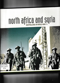
Book, Department of Veterans' Affair, North Africa and Syria : Australians in World War II, 2012
A pictorial account of the Australian army involvement in the North Africa and Syrian campaigns during World war twoIll, maps, p.167.non-fictionA pictorial account of the Australian army involvement in the North Africa and Syrian campaigns during World war twoworld war 1939 – 1945 – campaigns – north africa – syria, australian army - pictorial works - north africa - syria -
 Monbulk RSL Sub Branch
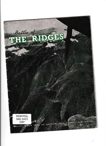
Book, Department of Information, Battle of the Ridges, 1943
Australian army brochure relating to the attack on Salamaua in 1943Ill, p.32.non-fictionAustralian army brochure relating to the attack on Salamaua in 1943world war 1939 – 1945 – campaigns – new guinea, world war 1939-1945 - australia -
 Monbulk RSL Sub Branch
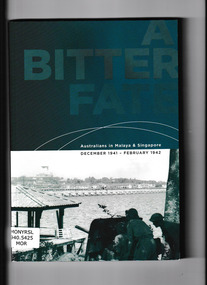
Book, Department of Veterans' Affairs, A bitter fate : Australians in Malaya & Singapore, December 1941 - February 1942, 2002
B/W and colour illustrations and stories on the Japanese invasion of Malaya and Singapore and the experiences of the Australian Forces in 1941/42.Notes, ill, maps, p.146.non-fictionB/W and colour illustrations and stories on the Japanese invasion of Malaya and Singapore and the experiences of the Australian Forces in 1941/42. world war 1939 – 1945 – campaigns – malaya, siege of singapore -
 Monbulk RSL Sub Branch
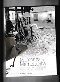
Book, Commonwealth Department of Veterans, Memories & memorabilia : recognising and preserving Australia's war heritage, 2014
A guide to Australia's war heritage. To provide opportunities for future generations to understand, investigate and value these experiences, we must ensure that the significant material relating to Australia's war heritage is preserved.Ill, p.88.non-fictionA guide to Australia's war heritage. To provide opportunities for future generations to understand, investigate and value these experiences, we must ensure that the significant material relating to Australia's war heritage is preserved.war memorials - australia - conservation and preservation, world war 1939 – 1945 – personal narratives – australia -
 Monbulk RSL Sub Branch
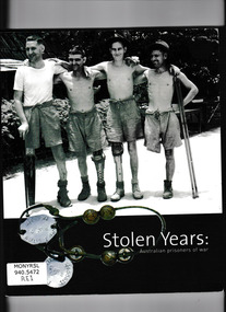
Book, Department of Veterans' Affair, Stolen Years : Australian Prisoners of War, 2002
Created by the Australian War Memorial, this book is an online companion to a travelling exhibition that explores the lives of those who were held captive by the Japanese. It describes what happened during the time these individuals spend months and years behind barbed wire, hungry, bored, cold, and sick. The book tells the story of how many survived and why they deserve our respect and understanding.Ill, p.157.non-fictionCreated by the Australian War Memorial, this book is an online companion to a travelling exhibition that explores the lives of those who were held captive by the Japanese. It describes what happened during the time these individuals spend months and years behind barbed wire, hungry, bored, cold, and sick. The book tells the story of how many survived and why they deserve our respect and understanding. world war 1939 – 1945 - prisons and prisoners – australia, prisoners of war - australia - pictorial works -
 Monbulk RSL Sub Branch
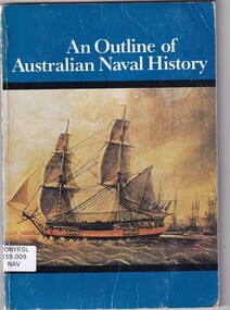
Book, Department of defence (Navy), An outline of Australian naval history, 1976
A brief history of Australian naval historyBibliography, ill (b/w), p.71.non-fictionA brief history of Australian naval historyroyal australian navy - history, naval operations - australia -
 Monbulk RSL Sub Branch
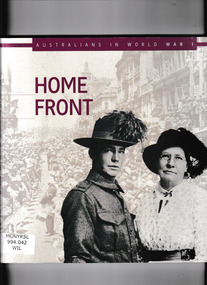
Book, Department of Veterans' Affairs, Home front, 2011
Pictorial essay depicting social conditions in Australia during the First World WarIll, p.135.non-fictionPictorial essay depicting social conditions in Australia during the First World Warworld war 1914-1918 - military policy, world war 1914-1918 - social conditions - australia -
 Monbulk RSL Sub Branch
Book, Australian Department of Defence, Recollections of the Roving Staff Officer, 1993
The personal experiences of John Buckley as the roving staff officer in a variety of theaters during World War Two.Index, bibliography, ill, p.341.non-fictionThe personal experiences of John Buckley as the roving staff officer in a variety of theaters during World War Two.world war 1939-1945 - personal narratives, world war 1939-1945 - political aspects -
 Monbulk RSL Sub Branch
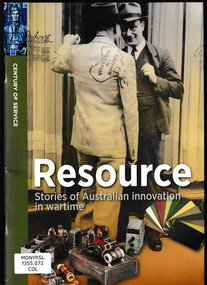
Book, Department of Veterans' Affairs, Resource : stories of Australian innovation in wartime, 2016
This book explores examples of Australian wartime innovation, some of which occurred in Australia - in laboratories, offices and homes - and some on the battlefields where Australians have fought.Index, bib, ill, p.51.non-fictionThis book explores examples of Australian wartime innovation, some of which occurred in Australia - in laboratories, offices and homes - and some on the battlefields where Australians have fought.technical innovations - australia, military history - australia -
 Monbulk RSL Sub Branch
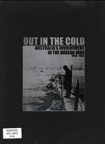
Book, Ben Evans, Out in the cold: Australia's involvement in the Korean war 1950-1953, 2010
An illustrated history of the Australian involvement in the Korean conflict.Ill, maps, p.88.non-fictionAn illustrated history of the Australian involvement in the Korean conflict. korean war 1950-1953 - australian involvement, korean war - commonwealth forces -
 Monbulk RSL Sub Branch
Book, Aurum Press Ltd, The secret listeners : The men and women posted across the world to intercept the secret german codes for Bletchley Park, 2012
Before Bletchley Park could break the German war machine's code, its daily military communications had to be monitored and recorded by 'the Listening Service', the wartime department whose bases moved with every theatre of war (Cairo, Malta, Gibraltar, Iraq, Cyprus) as well as having listening stations along the eastern coast of Britain to intercept radio traffic in the European theatre. This is the story of the - usually very young - men and women sent out to farflung outposts to listen in for Bletchley Park, an oral history of exotic locations and ordinary lives turned upside down by a sudden remote posting - the heady nightlife in Cairo, filing cabinets full of snakes in North Africa, and flights out to Delhi by luxurious flying boat.Index, ill, map, p.354.non-fictionBefore Bletchley Park could break the German war machine's code, its daily military communications had to be monitored and recorded by 'the Listening Service', the wartime department whose bases moved with every theatre of war (Cairo, Malta, Gibraltar, Iraq, Cyprus) as well as having listening stations along the eastern coast of Britain to intercept radio traffic in the European theatre. This is the story of the - usually very young - men and women sent out to farflung outposts to listen in for Bletchley Park, an oral history of exotic locations and ordinary lives turned upside down by a sudden remote posting - the heady nightlife in Cairo, filing cabinets full of snakes in North Africa, and flights out to Delhi by luxurious flying boat.world war 1939-1945 - great britain - intelligence, world war 1939-1945 - cryptography -
 Monbulk RSL Sub Branch
Book, Department of Veterans Affairs, Sandakan 1942-1945, 2014
Illustrated history of the Sandakan death marches. Includes a roll of honourIll, maps, p.138.non-fictionIllustrated history of the Sandakan death marches. Includes a roll of honourworld war 1939-1945 - prisoners of war - sandakan, world war 1939-1945 - prisoners and prisons - japan -
 Whitehorse Historical Society Inc.
Document, Archaeology of Aboriginal sites, 11/04/1984
Summary of a talk by Gary Presland of the Victorian Department of Archaeology by Joan Roczniok on the archaeology of aboriginal sites in the Melbourne Metropolitan area. Archaeological practices, Aboriginals, whalers, French Island, Keilor site, Main Street, Blackburn, canoe tree, axes, hunting and fishing methods.aborigines, main street, blackburn, blackburn, french island, keilor, archaeology -
 Department of Health and Human Services
Photograph, Colanda Grounds - Main Ring road looking down at Eagle, Finch and Dove units
The Colac, Victoria-based Colanda Centre was one of the last Victorian institutions and offered disability accommodation from 1976, when it was established, until 2019, with its closure.Digitised colour photograph of Main Ring Road in Colac, overlooking Colanda's Eagle, Finch and Dove unitscolanda, colac, disability services, residential services, disability, digitised photograph -
 Department of Health and Human Services
Photograph, Colanda Grounds - Main Ring road looking down at Eagle, Finch and Dove units
The Colac, Victoria-based Colanda Centre was one of the last Victorian institutions and offered disability accommodation from 1976, when it was established, until 2019, with its closure.Digitised colour photograph of Main Ring Road, a view of the Colanda Centre Eagle, Finch and Dove units. colanda, colac, disability services, residential services, disability, digitised photograph -
 Ballarat Tramway Museum
Administrative record - Log book, Diary, Collins Bros, 1963
Yields information about the track maintenance activities of the track gang in Ballarat, the work they did, notes, names and other information.Collins Australian Diary, No. 324 printed by Collins Bros, dark red card covers, sewn sections with ruled sheets providing a diary for 1964, one week per double page. Has "useful information" sheets at from the diary. Used by the SEC Ballarat track gang to record their daily work, leave, welding, track cleaning, truck driver etc In the Memoranda section (page 3 and 4), list of names and addresses of track gang and notes on materials used, costs, scrubber use and hours, and length of track. Lancaster Wiseman Lakey Edwards Fish Dowie Marks Smith Bartlett W. Gladman R. J. Gladman Loose contents 1. 27/12/64 - Handwritten notes (2) re work to be done and leave 2. - Memoranda - handwritten note on rear of weekly time sheet - note re materials and leave times for gang. 3 - Inside rear cover - Note from the Accounts department dated 9/8/1963 re account numbers to used by the truck driver - note re D. Wiseman - Long Service leave - workshop requisition and note - re work at B power station - repairs to road - workshop requisition to dig trenches in Main St - note re work on the back of a letter from the Shell Sou'wester service station re the availability of touring maps.tram, trams, sec, ballarat, depot, trackwork, rails, scrubber tram -
 Otway Districts Historical Society
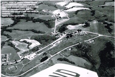
Photograph, R. Preston, Aerial view: Beech Forest, 1965, 13 February 1965
B/W. Aerial view of Beech Forest showing the complete station yard including the balloon loop (incorporating the two tennis courts), two ex-departmental residences, the station building and where the Colac and Crowes lines diverged. As well Beech Forest Hall, council offices and Shire Secretary's house, Denherts Track, and Main Road are shown.beech forest; railways; township; aerial; -
 Bayside Gallery - Bayside City Council Art & Heritage Collection
Photograph, Department of Crown Lands and Survey, Victoria, Melbourne Project: Brighton and Elwood, 1976
The Department of Crown Lands and Survey (1857-1983) was responsible for the administration of survey and mapping and the sale, occupation and management of crown land throughout its existence. This aerial photograph shows parts of Brighton and Elwood and was taken on 1 December 1976brighton, elwood, department of crown lands and survey, aerial photograph, elsternwick park, point ormond, north road, ormond esplanade, st kilda street, glen huntly road, bayside, port phillip bay, map, cartographic material, melbourne project 1976 -
 Bayside Gallery - Bayside City Council Art & Heritage Collection
Photograph, Department of Crown Lands and Survey, Victoria, Melbourne Project: Brighton, Hampton, Sandringham, 1976
The Department of Crown Lands and Survey (1857-1983) was responsible for the administration of survey and mapping and the sale, occupation and management of crown land throughout its existence. This aerial photograph shows parts of Brighton, Hampton and Sandringham and was taken on 1 December 1976brighton, department of crown lands and survey, aerial photograph, bayside, port phillip bay, map, cartographic material, hampton, sandringham, green point, sandringham yacht club, south road, beach road, hampton street, melbourne project 1976 -
 Bayside Gallery - Bayside City Council Art & Heritage Collection
Photograph, Department of Crown Lands and Survey, Victoria, Melbourne Project: Brighton, 1976
The Department of Crown Lands and Survey (1857-1983) was responsible for the administration of survey and mapping and the sale, occupation and management of crown land throughout its existence. This aerial photograph shows parts of Brighton and was taken on 1 December 1976brighton, department of crown lands and survey, aerial photograph, bayside, port phillip bay, map, cartographic material, melbourne project 1976, brighton yacht club, middle brighton baths, north road, st kilda street, new street -
 Bayside Gallery - Bayside City Council Art & Heritage Collection
Photograph, Department of Crown Lands and Survey, Victoria, Melbourne Project: Brighton and Hampton, 1976
The Department of Crown Lands and Survey (1857-1983) was responsible for the administration of survey and mapping and the sale, occupation and management of crown land throughout its existence. This aerial photograph shows parts of Brighton and Hampton and was taken on 1 December 1976. brighton, department of crown lands and survey, aerial photograph, bayside, port phillip bay, map, cartographic material, melbourne project 1976, brighton yacht club, middle brighton baths, hampton, green point, brighton beach, south road, the esplanade, hampton street -
 Bayside Gallery - Bayside City Council Art & Heritage Collection
Photograph, Department of Crown Lands and Survey, Victoria, Brighton, Elwood and Elsternwick, c. 1965-71
The Department of Crown Lands and Survey (1857-1983) was responsible for the administration of survey and mapping and the sale, occupation and management of crown land throughout its existence. This aerial photograph shows parts of Brighton, Elwood and Elsternwick and was taken circa 1965-71.brighton, department of crown lands and survey, aerial photograph, bayside, port phillip bay, map, cartographic material, elwood, elsternwick, elsternwick park, elwood tram depot, elwood pier, new street, glen huntly road, st kilda street, nepean highway -
 Bayside Gallery - Bayside City Council Art & Heritage Collection
Photograph, Department of Crown Lands and Survey, Victoria, Brighton, Brighton East and Bentleigh, c. 1965-71
The Department of Crown Lands and Survey (1857-1983) was responsible for the administration of survey and mapping and the sale, occupation and management of crown land throughout its existence. This aerial photograph shows parts of Brighton, Brighton East and Bentleigh and was taken circa 1965-71.brighton, department of crown lands and survey, aerial photograph, bayside, port phillip bay, map, cartographic material, bentleigh, brighton east, dendy park, dendy street, centre road, nepean highway, south road, football -
 Bayside Gallery - Bayside City Council Art & Heritage Collection
Photograph, Department of Crown Lands and Survey, Victoria, Brighton, Brighton East and Bentleigh, c. 1965-71
The Department of Crown Lands and Survey (1857-1983) was responsible for the administration of survey and mapping and the sale, occupation and management of crown land throughout its existence. This aerial photograph shows parts of Brighton and Brighton East and was taken circa 1965-71.brighton, department of crown lands and survey, aerial photograph, bayside, port phillip bay, map, cartographic material, brighton east, dendy park, dendy street, centre road, nepean highway, south road, brighton golf course, golf -
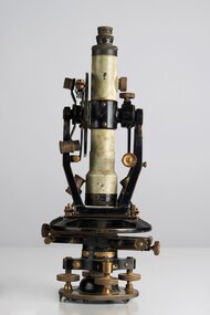 City of Greater Bendigo - Civic Collection
Instrument - Theodolite, E. R. Watts & Sons, c 1930
Theodolites are a highly accurate instrument that measures angles between designated visible points in the horizontal and vertical planes. The theodolite has a long history, with the term first found in 1571 in a surveying textbook 'A geometric practice named Pantometria' by Leonard Digges. (source https://en.wikipedia.org/wiki/Theodolite). Theodolites are used by surveyors as part of their everyday work and although there is no specific information regarding the provenance of this particular one it is assumed it was used locally by the Shire of Marong and / or the Lands Department. Edwin Watts started the company in 1856, trading up to 1920s as E.R. Watts & Son with E. R. Watts & Son Ltd amalgamating with Adam Hilger Ltd to form Hilger & Watts in 1948.0442.1 A black and grey theodolite no 39161 made by Watts & Sons. Various moving parts showing signs of extensive use particularly on the uprights on the main body and around knobs and dials where the paint is worn back to brass. Is housed in original box with key, oil container and pin. 0442.2 handwritten instructions for making adjustments to the Theodolite written on the back of Road Users' Association of Victoria letterhead note paper.Watts & Sons / London / 5974 For N H Seward / Melbournelands and survey department bendigo, shire of marong -
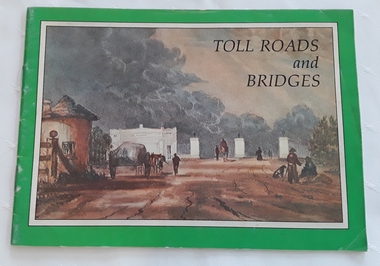 Mont De Lancey
Booklet, Department of Main Roads, Toll Roads and Bridges, 1981
... Department of Main Roads... Booklet Department of Main Roads National Association ...A brief history of tolls used throughout history, dating back around 1950 B.C. Early English and USA use is mentioned. Road and bridge tolls in Australia were collected for construction and maintenance of particular roads and bridges similar to their use in England. The clear photographs show the development in the this country up to 1981 when the brochure was published.A small slim rectangular paperback brochure with a lithograph of the "New Toll Gate" on Parramatta Road, published in J.G. Austin's Sydney Views. Green and white edging surrounds the picture with the title Toll Roads and Bridges printed in black lettering at the top right of the cover. On the back is a photograph of Toll cabins at the northern end of the Sydney Harbour Bridge showing automatic and manual toll booths with the symbol for NAASRA and National Association of Australian State Road Authorities printed in black and white at the bottom. Pp. 20. There are many photographs inside.non-fictionA brief history of tolls used throughout history, dating back around 1950 B.C. Early English and USA use is mentioned. Road and bridge tolls in Australia were collected for construction and maintenance of particular roads and bridges similar to their use in England. The clear photographs show the development in the this country up to 1981 when the brochure was published.road tolls, roads, bridges, history of tolls -
 Wodonga & District Historical Society Inc
Album - Hume Reservoir Australia Album - Plans and Progress Photos - River Murray Water Scheme, Department of Public Works, N.S.W, 1927
This set of photos is from a leather bound album bearing the inscription "HUME RESERVOIR AUSTRALIA" plus 'The Rt. Hon. L. C. M. S. Amery, P. C., M .P.' all inscribed in gold. It was presented to The Rt. Hon. L. C. M. S. Amery, P. C., M. P, Secretary of State for Dominion Affairs on the occasion of his visit to the Hume Reservoir on 2nd November 1927. This album is of local and national significance as it documents the planning and development of the Hume Reservoir up to 1927. It was the largest water reservoir in the British Empire. The album records the pioneering engineering work that went into its construction.1. Locality Plan and Plan of Dam. The dam is about ten miles by road upstream from Albury and about three-quarters of a mile below the confluence of the Mitta Mitta River and the Murray River. Its main features consist of a concrete portion across the bed of the river with earth embankment at both ends. The foundations throughout are on hard granite, found at an average depth of about 40 feet below the surface, the centre line being located to take advantage of the most favourable rock levels.Heading on page "WORKS UNDER RIVER MURRAY WATERS AGREEMENT/HUME RESERVOIR" Beneath top diagram "FIG. 1. ELEVATION" Beneath second diagram "FIG. 2. PLAN" On map "LOCALITY PLAN"hume reservoir australia, river murray waters scheme, hume weir diagrams, hume weir location -
 Federation University Historical Collection
Map - Geological Survey, J. Phillips, Geological Survey of Victoria - Ballarat, 1857, 10/1858
Geological map of the Ballarat District featuring four colours.ballarat, geological, geology, geological plan, main road, camp, golden point, pennyweight hill, clayton hill, ballaarat cemetery, bakery hill, specimen hill, soldiers hill, nightingale lead, native youth black hill flat, white flat, mining, mines, eureka lead, old post office hill -
 Eltham District Historical Society Inc
Document - Map, Victoria. Department of Crown Lands and Survey, Town of Eltham, Parish of Nillumbik, County of Evelyn, 2 October 1929
Township of Eltham, Parish of Nillumbik, County of Evelyn / lithographed at the Department of Lands & Survey Melbourne 5th June 1888, amended 2 October 1929 This amendment from the 1888 original shows the reserve for the the State School marked as permanent with dimensions added to Main Road and block frontages along Main Road between Mount Pleasant Road and Dalton Street and Metery Road Possibly photocopied from a copy held at PROV by Harry Gilham whilst resaerching Eltham Primary School history in 1995.a. armstrong, a. lavard, arthur c. allan, arthur c. allen, b. bowatere, baxter street, benjamin oliver wallis, bolton steet, c. souter, c.s. hain, cemetery reserve, charles brown, charles newman, charles symons wingrove, christopher caldwell, church of england, d. anderson, dalton street, david ballard, e. james, e.m. peck, edward dumaresq, eltham town, ely street, f.e. falkiner, f.m. peck, falkiner street, flint street, g. buckingham, g. drabble, george stebbing, godalmin street, h. peck, h.c.whess, h.h. farquharson, h.j. bews, henry stooke, j. goer, j. mcdonald, j. mclaren, j. roberts, j.b. knagers, james irish, jane bailey (nee matthews), john l. smith, john mason, john scott, john smith, joseph stevenson, joseph verse, k. wingrove, k.e. dunstan, kerby street, kirby street, location tbd, m. coman, map, michael o'shea, o.b. mccutcheon, p. & g. tumbull, p.k. mccaughan, p.p. cotter, porter street, pound reserve, robert hepburn, roman catholic church, s. evans, samuel dagley, samuel phillips, samuel ramsden, t. upton, t. watkins, t.a. stark, t.c.b. batt, t.p. cross, thomas grant, thornton street, w. adam, w. blain, w. long, w. watkins, w.f. ford, w.h. hull, w.r. belcher, w.t. schultz, william thomas, eltham primary school, eltham state school, eltham state school no. 209, quarry reserve -
 Eltham District Historical Society Inc
Document - Report, Paul Jerome, Advisory Committee on a Proposed Convenience Centre and an Alternative Shire Proposal - Eltham Gateway Community Precinct Concept Plan - 895 Main Road Eltham, October 1997
On 15 December 1994 the former Shire of Eltham ceased to exist following the Liberal Kennett Government local council amalgamations. A new Nillumbik Shire Council was established with unelected commissioners appointed. That Council sold the former Eltham Shire Council Offices and land at 89S Main Road Eltham to Dallas Price Homes Pty. Ltd. the sale being conditional upon the granting of a planning permit for a petrol station/convenience store, fast food and video outlet. The sale was conditional that if the permit was not granted by 30 August. 1997, the contract could be avoided by either the purchaser or the vendor. The proposed development consisted of a petrol station with undercover fuelling facilities, convenience shopping, a drive through service facility for fast food, an 80 seat cafe, automated banking, a children's play area and retail space. In addition, the proposal included a 200 square metre community facility for Council use, provision of on site carparking over 2 levels for 83 vehicles, and advertising signage. An Advisory Committee consisting of Dimitry Reed and Margaret Pitt was appointed under Section 151 of the Planning and Environment Act 1987 to hear submissions on the proposal to develop the land at 895 Main Road Eltham, the site of the former Eltham Shire Offices. In September 1996, two applications were made by Contour Consultants Australia Pty Ltd on behalf of Dallas Price Homes Ply Ltd, to Nillumbik Shire Council. After extensive notification, the Council received 213 objections and a petition of over 1400 signatures. On October 9, 1996, Nillumbik Shire Council issued Notices of Decision to Grant Permit on Applications number 96/03376 and 96/0377 for the use and development of the land as a convenience Centre consisting of a petrol station, convenience store, cafe/takeaway food premises, a retail facility and a community facility, with associated advertising signs. Objectors to the proposals lodged Planning Appeals number 96/40724 and 96/40812 with the Administrative Appeals Tribunal on November 1, 1996. The grounds of appeal can be summarised as: inappropriate development, insufficient carparking, traffic and access issues, unsatisfactory design, inadequate permit conditions, the proposal being out of character with the area. and being contrary to the purpose and orderly development of the Eltham Town Centre, excessive noise, lack of consultation and unsuitable signage. On November 13, 1996, the Minister for Planning and Local Government directed the Registrar of the Administrative Appeals Tribunal. under Section 41 (1) (a) of the Planning Act 1980, to refer the Appeals to the Governor in Council for determination without a hearing or recommendation by the Tribunal. The Minister for Planning and Local Government called in the Appeals as he considered that they raised major issues of policy relating to the facilitation of development in accordance with the objectives set out in Section 4 of the Planning and Environment Act 1987, and that determination of the Appeals could have a substantial effect on the achievement of these planning objectives. The Minister required the Advisory Committee to consider the planning merits of the proposed use and development, and to address the issues raised in the objections. The Advisory Committee was required to produce a report providing: • The Committee's response to the matters detailed; • Relevant supporting information for the Advisory Committee's recommendation; and • A description of the proceedings conducted by the Advisory Committee and a list of those consulted or heard by the Committee. In March 1997, elections were held in the Shire of Nillumbik and the view of the new Council to this proposal differed from the view held by the earlier Council Hence the Submission made to the Committee by the Shire was against the decision by the Shire of Nillumbik to issue the Notices of Decision to Grant a Permit. The Recommendations of the Advisory Committee were: i. The cafe and take away food premises are as of right uses and are therefore allowable, but that shop and petrol station are unacceptable uses. A community facility is a discretionary use and is acceptable. ii. A development of the type and scale proposed is totally inappropriate for this land and that the Applications number 96/03376 and 96/0377 for the use and development of the land as a convenience Centre consisting of a petrol station, convenience store, café/takeaway food premises, a retail facility and a community facility, with associated advertising signs, be refused. iii. The land should be rezoned for public purposes and should remain in the community's ownership for community use. Following this, the Minister for Planning and Local Government, the Hon. Robert Maclellan, appointed Mr. Paul Jerome as an Advisory Committee under section 151 of the Planning and Environment Act 1987 to consider a Convenience Centre and an alternative proposal by Iha Shire of Nillumbik being the Eltham Gateway Community Precinct Concept Plan for the site of the former Shire of Eltham municipal offices at 895 Main Road, Eltham. In summary, the terms of reference for the Advisory Committee required it to: • consider the merits of the Council proposal • examine the merits of both proposals in terms of net community benefit • address the report of the previous Advisory Committee on the Convenience Centre proposal The Advisory Committee inspected the site and considered all the material before It including submissions made by all parties to the previous Advisory Committee and correspondence received by the Department of Infrastructure both before and after that Committee submltted its report. The Advisory Committee also held discussions with the following people: • Cr. Robert Marshall • Cr. Margaret Jennings • Cr. Lex de Man • Mr. Dallas Howgate of Dallas Price Properties, also Dallas Price Homes • Mr. Barry Rochford, CEO, Shire of Nillumbik • Ms. Yvonne Rust, Planning Officer, Shire of Nillumbik • Mr. Gregory Burgess, Architect of the Eltham Library and of Council’s Community Precinct Concept Plan • Mr. Jim Connor representing Mrs Thelma Barkway of the Eltham Senior Citizens Club Having considered all the material before it, the Committee arrived at two basic conclusions. First, the DPP proposal should be rejected because, on its merits, It does not sufficiently satisfy the requirements of the planning scheme which is a statutory document. The planning scheme requires that, before making a decision on the permit applications for the DPP proposal, a range of matters must be considered. It follows that consideration of these matters should Influence the decision. These matters include local policies relating to character and amenity. In particular, these policies seek • to conserve and enhance the bushland/country atmosphere, artistic heritage and strong sense of community of the Eltham Town Centre by ensuring that the design and height of any new development is sympathetic to existing buildings • to achieve a pleasing physical environment within the Eltham Town Centre by encouraging a high standard of architecture and urban design • to encourage Improvement to pedestrian amenity through such facilities as open and shattered rest areas and meeting places, crossing facilities, pedestrian arcades, pedestrian links to car parks and pedestrian weather protection • to reduce conflict between vehicular traffic and pedestrian flows, and • to encourage pedestrian thoroughfares It is submitted, as set out In the main body of this report, that the DPP proposal fails substantially to meet these policies and In so doing does not merit the exercise of discretion In Its favour with the Issuing of a permit. This finding is not offset by the investment and employment attributes of the proposal. They do not override the need to comply with the planning scheme. Second, the Council proposal, on Its own merits, substantially meets all statutory requirements applicable to this site with a possible reservation about car parking and traffic management which need further definition and assessment as the concept is refined. The Council proposal, however, has a serious weakness in that Its financial viability has not been adequately tested. The Committee refers to 'financial' rather than 'commercial' viability in recognition that Council owns the land and may enter into a range of agreements and partnerships to realise its concept some of which may be truly commercial and some of which may involve an element of subsidy arising from Council's involvement as a public body acting on behalf of its community. The Committee concludes that Council should be given the opportunity, within a reasonable timeframe to establish the financial feasibility of its concept and should develop a strategy for the future of Its land asset at 895 Main Road in the event that Its concept for the site cannot be realised. 895 main road, advisory committee, dallas price homes, eltham, eltham shire office, nillumbik shire council, planning application, administrative appeals tribunal