Showing 1699 items matching "maps and documents"
-
 Bendigo Historical Society Inc.
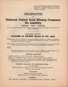
Document - MCCOLL, RANKIN AND STANISTREET COLLECTION: PROSPECTUS OF DEBORAH UNITED GOLD MINING COMPANY NL, DEBORAH REEF, 1940
Document: McColl, Rankin and Stanistreet: , grey booklet. Prospectus of Deborah United Gold Mining Company. Includes map of minesorganization, mining, mccoll, rankin and stanistreet: , deborah united gold mining company nl, deborah reef, prospectus -
 Bendigo Military Museum
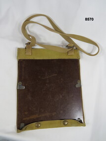
Equipment - FIELD CASE, MAP, Unknown
Khaki over the shoulder field case for maps or documents. The backing base is covered in cotton khaki material with bottom press stud closure buttons. Maps or documents are held in place by adjustable slide over clips. On the inside of the cover there are six sewn in narrow pockets for pens, pencils and relevant recording items.passchendaele barracks trust, field case, maps and documents -
 Bendigo Historical Society Inc.
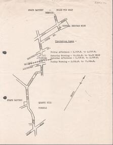
Document - ALBERT RICHARDSON COLLECTION: STATE BATTERY BELLE VUE ROAD, BENDIGO
One page document with map sowing the location of the State Battery Quarry Hill. Visitation times are given, presumably it was a tourist destination.bendigo, mining, state battery -
 Peterborough History Group
Document - Resources for Aboriginal information, 2013-2020
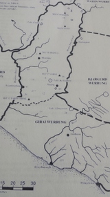
Collection of documents from various sources put into one folderSignificant because it directs the reader to sources of further research about the aboriginal culture in the district.Looseleaf folder containing photocopies of various documents, maps, extracts from books all pertaining to the aboriginal prehistory of the Peterborough area.girrai wurrung, peterborough aboriginal history -
 Lakes Entrance Historical Society
Book, Love Don, Shipwrecks around Port Phillip Heads, 2007
Well documented stories of the shipwrecks around Port Phillip Heads Victoria 1840-1900 with references photographs location Map and sketches.ships and shipping, history -
 Bendigo Historical Society Inc.
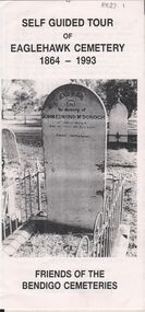
Document - BENDIGO CEMETERIES COLLECTION: SELF GUIDED TOUR EAGLEHAWK CEMETERY DOCUMENT
BHS CollectionWhite trifold document. Self guided tour of Eaglehawk Cemetery 1864 - 1993 Friends of the Bendigo Cemeteries. Document details significant graves in the old monumental section 1864 - Map of graves and 35 graves described.Annette O'Donohue, Bev Hanson.bendigo, cemetery, eaglehawk cemetery -
 Bendigo Historical Society Inc.
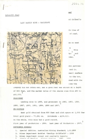
Document - ALBERT RICHARDSON COLLECTION: LADY BARKLY MINE, EAGLEHAWK
One page document, plus map, with information on the Lady Barkly Mine, New Chum line of reef, Eaglehawk. The location, early history, prominence, and gold production are described. References given on bottom of document. Document forms part of research referred to in Albert Richardson's paper 2264.70.bendigo, mining, lady barkly mine eaglehawk -
 Ringwood and District Historical Society
Document, Collection of copies of Maps relating to Wieland Houses and Properties (most undated), plus Document entitle Brian Pump's Orchard and House Locations, 25/2/2008
... Collection of copies of Maps relating to Wieland Houses and ...Collection of A4 photocopies of maps and plans, some with yellow highlighting, showing locations of Wieland properties and house including sub-divisions. Mostly in Heathmont but also Scoresby Most pages are undated and do not have original sources Document 28054 entitled Brian Pump's Orchard and House Locations has notes with maps of various houses with numbers corresponding to those on the included maps and also to those in 28054-003 document -
 Bendigo Historical Society Inc.
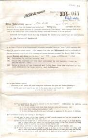
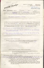
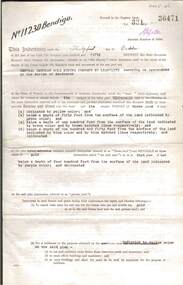
Document - MCCOLL, RANKIN AND STANISTREET COLLECTION: BENDIGO EXTENDED GOLD MINING COMPANY N/L MINING LEASE, 13 November 1956
Document: Bendigo Extended Gold Mining Company gold mining lease. 4 page document with attached map. Map shows area running roughly parallel to Adam Street, Quarry Hill. Lease between Bendigo Extended Gild Mining Co. N/L and State of Victoria. No. 11328, Vol 334 Fol 047.organization, mining, gold mining lease, bendigo extended gold mining co n/l; gold mining lease -
Port Melbourne Historical & Preservation Society
Map - VACCUUM Road Guide to Victoria
The Mathews family have been in continuous ownership of 395 Howe Parade (was 8 Howe Parade until 1964 when addresses re-assigned), Port Melbourne from 1938 to the present (Sept 2019)Six folders of assorted documents relating to the life of Alan Mathews and his family. Employment documents. Folder 4 has Motor car purchases, Registration, Licences & RACV Road map. VACCUUM Road Guide to Victoriatransport - motor vehicles, alan mathews, commonwealth aircraft corporation, cac -
 Bendigo Historical Society Inc.
Document - MCCOLL, RANKIN AND STANISTREET COLLECTION: GOLD MINING LEASE RONALD ALEXANDER RANKIN, 1941
Document: McColl, Rankin and Stanistreet: lease document between Ronald Alexander Rankin of Bendigo and the State of Victoria. 3 pages with map - lease adjoins Bellevue Road. Lease transferred to Deborah Gold Mines NL in 1945.organization, mining, gold mining lease, mccoll, rankin and stanistreet:, ronald alexander rankin, lease document, gold mining -
 Greensborough Historical Society
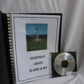
Folder and compact disc, Simpson Army Barracks, 2011_
This document is the result of research into the history of Watsonia Barracks (now Simpson Barracks) by GHS member Marilyn Smith. It details the origin of street names in the surrounding area and includes biographical information on those after whom the streets were named. Updated December 2016.The Watsonia Barracks has been in use since WW2 and is today home to the Defence Force School of Signals. It was built on the property formerly owned by Ainslie Meares. In 1951, surrounding land was purchased for the extension of the barracks. The suburb of Yallambie was formerly part of the Barracks. Black spiral bound folder (approx. 32 pages) with accompanying compact disc. Colour illustrations and maps. Updated 2016 in Word document.simpson army barracks, watsonia barracks, yallambie, marilyn smith, watsonia -
Lakes Entrance Historical Society
Book, Harcourt, Rex, Southern Invasion - Northern Conquest. Story of the Founding of Melbourne, 2001
An account of the most notable events behind the founding of Melbourne. Includes excerpts from important documents, photographs, maps, reference notes and index.settlers, industrial -
Clunes Museum
Document - SURVEYORS MAP, A.C. BROOKS GOVERNMENT PRINTER MELBOURNE, 1937
... documents ...NO.2 COPY OF NOTES TAKEN FROM DIARY 1865 THOUGHT TO BE WRITTEN BY JESSE HOARE SMITH WHO WAS A SURVEYOR AT CLUNES AT THE TIME. DIARY TURNED UP IN NORTH QUEENSLAND AND NOW IN POSSESSION OF A CRESWICK MAN.NO.1 SURVEYORS MAP TALBOT AND SURROUNDING TOWNS 1937. NO.2 DIARY NOTES 1865 THOUGHT TO BE WRITTEN BY JESSE HOARE SMITHlocal history, documents, maps, weickhardt, wattleworth -
 Bendigo Historical Society Inc.
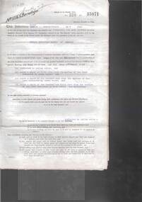
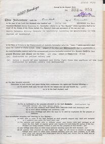
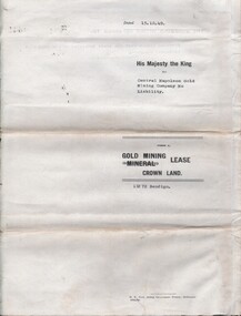
Document - MCCOLL, RANKIN AND STANISTREET COLLECTION: INDENTURE NORTH DEBORAH MINING COMPANY, 20th November, 1952
6 page document ' Gold Mining Lease Crown land Number 11307 Bendigo' plus map. Indenture document between Queen Elizabeth 11 and North Deborah Mining Company No Liability, Parish of Sandhurst, dated 20th November, 1952 re Vol 333, Folio 053. Land indicated by yellow on map and below ' a depth of one hundred and fifty feet from the surface of the land indicated by purple colour and delineated on the plan' Document signed by J. Stanistreet, Manager, North Deborah Mining Company No Liability. Map, fixed to document, heading ' Mining District of Bendigo, No. 11307, County of Bendigo, Parish of Sandhurst, Total area 13 acres 2 roods, 11 perches. Map shows large dam on Crown land, transmission line excised 150 ft., written on purple area. Underneath map ' provided that the dam indicated on the said plan is hereby reserved'.bendigo, mining, north deborah mining company -
 Bendigo Historical Society Inc.
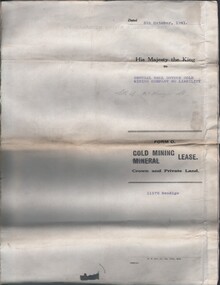
Document - MCCOLL, RANKIN AND STANISTREET COLLECTION: GOLD MINING LEASE CROWN LAND, 1937
Document : McColl, Rankin and Stanistreet: gold mining lease crown land 10916 Bendigo. Foolscap size document, includes map County of Bendigo, Parish of Mandurang. Dated 1937 between King George VI and John Jepson Stanistreet.person, mining, john jepson stanistreet, mccoll, rankin and stanistreet: bendigo, mining, goldmining, john stanistreet -
 Bendigo Historical Society Inc.
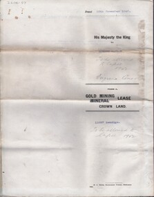
Document - MCCOLL, RANKIN AND STANISTREET COLLECTION: CENTRAL DEBORAH GOLD MINING COMPANY N/L GOLD MINING LEASE, 31 October 1950
Document: Central Deborah Gold Mining Company N/L gold mining lease. 4 page document with attached map. Map shows area from Breen Street to Victoria Street following the line of Old Violet Street.. Lease between Central Deborah Gold Mining Company N/L and the State of Victoria. No. 11230, Vol 331 Fol 36471.organization, mining, gold mining lease, central deborah gold mining company n/l; gold mining lease -
Bendigo Historical Society Inc.
Document - BASIL MILLER COLLECTION: TRAM, TRAMWAY ROUTES AND SECTION DESTINATIONS, c1971?
Document. State Electricity Commission of Victoria. Electricity Supply Department - Bendigo Tramways. Tramway routes and section destinations. 15 copies of same route map.organization, business, bendigo trams -
Lakes Entrance Historical Society
Book, Orbost Historical Society Inc, Barns of the Snowy River Orbost, 2006
Documents the distinctive slatted barns of the Lower Snowy River, Orbost, Victoria. Includes sketch maps, barn plans, history of area and families and personal ineterviews.Ngaire Donald May Leatchland settlement, agriculture, natural disasters, transport -
 Bendigo Historical Society Inc.
Document - FOSTERVILLE GOLD MINE COLLECTION: OPEN DAY 2018
2 page document, coloured, titled 'Kirkland Lake Gold' and 'Welcome to the Fosterville Gold Mine Open Day 2018'. Document describes activities available to visitors on the 2018 Open Day, and a map of the mine site showing location of various displays.bendigo, mining, fosterville gold mine -
 Bendigo Historical Society Inc.
Document - MCCOLL, RANKIN AND STANISTREET COLLECTION: CENTRAL NAPOLEON GOLD MINING CO. N.L, 16th April 1951
Document: Letter to the Central Napoleon Gold Mining Co N.L from McColl Rankin & Stanistreet notifying the company that Mr J.Bakker's land application no 94/152 has been approved, marked in grey pencil on map located in document 2205.706a.organization, business, industrial - mining, mccoll rankin & stanistreet, mining, gold mining, central napoleon -
 Bendigo Historical Society Inc.
Document - MCCOLL, RANKIN AND STANISTREET COLLECTION: CENTRAL NELL GWYNNE, 5/10/1941
Document. Paper Document containing an indenture detailing lease between His Majesty the King to Central Nell Gwynne Gold Mining Company No Liability. Included is a map of the mining district of Bendigo Parish of Sandhurst. No 11172 Bendigo Vol 327 Fol 36016.McColl, Rankin & Stanistreetorganization, business, central nell gwynne, mccoll, rankin & stanistreet, central nell gwynne, gold mining, lease -
 Bendigo Historical Society Inc.
Document - MCCOLL, RANKIN AND STANISTREET COLLECTION: NORTH VIRGINIA GMC N L - TITLE DEED/LEASE, 30/11/1940
Document. Coarse cream coloured paper typed. Corrections and additions. Assistant Registrar of Titles. Made out to Robert Watson of Eaglehawk. Has map of lease in the back.McColl, Rankin & Stanistreetorganization, business, north virginia gmc n l, mccoll, rankin & stanistreet, north virginia gmc n l, r watson, gold mining, title deed/lease -
Tatura Irrigation & Wartime Camps Museum
Book, Albrecht Dümling, The Vanished Musicians, Jewish Refugees in Australia, 2016
Tells the stories of Jewish refugees brought to Australia, particularly those on the Prison Ship "Dunera". Emphasis on musicians.Many of the musicians were interned in camps in the Tatura Group of Internment Camps.Blue soft covered book with photos of musicians playing their instruments on front cover. There are maps,photos, sketches of musical programmes and copies of 0fficial documents required by the refugees.Exile Studies, Vol 14. ISBN 978-3-03-431951-3 jewish musicians - australia, jewish refugees - australia -
 Wodonga & District Historical Society Inc
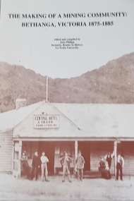
Book - The Making of a Mining Community: Bethanga, Victoria 1875 - 1885
A publication by La Trobe University to support the teaching of V.C.E History Unit 1: Local History. It is presented as 6 investigations focused on aspects of community through a case study of the Upper Bethanga district in Northeast Victoria from 1875 to 1885.A publication by La Trobe University to support the teaching of V.C.E History Unit 1: Local History. It consists of 94 pages including images, maps and document extracts.A publication by La Trobe University to support the teaching of V.C.E History Unit 1: Local History. It is presented as 6 investigations focused on aspects of community through a case study of the Upper Bethanga district in Northeast Victoria from 1875 to 1885.local history, vce resources, bethanga community, bethanga history -
 Bendigo Military Museum
Document - DOCUMENTS, DARWIN BOMBING, post WW2
Documents detail the first bombing raid on Darwin on 19 February 1942. Information related to subsequent raids also included..1) - .4) Collection of photocopied A4 documents related to the bombing of Darwin. 4 double sided pages in green plastic display folder. Black & white map & photos.documents - military history, passchendaele barracks trust, darwin -
Southern Sherbrooke Historical Society Inc.
Book - Local History, Victorian Government Printing Office on behalf of the Government of Victoria, Historical Records Of Victoria, Vol. 3, 1984
pp.xix, 670, paperback book, maps, photos, colour plates, index. A collection of documents concerning the development of Melbourne, Victoria, Australia, compiled by the Public Records Office, Victoria.foundation of melbourne -
 Bacchus Marsh & District Historical Society
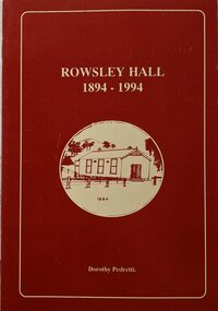
Booklet, Rowsley Hall 1894-1994
Rowsley is a rural locality 6km south-west of Bacchus Marsh. It is a very small community and the Rowsley Hall has been a community meeting place for over 100 years. This history tells the story of the origin of the Hall and its place in the community's history for its first 100 years. Citation: Rowsley Hall, 1894-1994, by Dorothy Pedretti. Published by Bacchus Marsh and District Historical Society, Bacchus Marsh, Vic., 1995?A small booklet. 36 unnumbered pages. Stapled binding. Contains black and white photographs, maps and facsimiles of documents. BMDHS Loc: AR/SU5/Pamphlets Box 4Rowsley is a rural locality 6km south-west of Bacchus Marsh. It is a very small community and the Rowsley Hall has been a community meeting place for over 100 years. This history tells the story of the origin of the Hall and its place in the community's history for its first 100 years. Citation: Rowsley Hall, 1894-1994, by Dorothy Pedretti. Published by Bacchus Marsh and District Historical Society, Bacchus Marsh, Vic., 1995?rowsley victoria history, halls, rowsley hall -
 Bendigo Historical Society Inc.
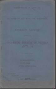
Document - MCCOLL, RANKIN AND STANISTREET COLLECTION: GOLD MINING INDUSTRY OF WESTERN AUSTRALIA, KALGOORLIE, 11th. May 1927
Document: McColl, Rankin & Stanistreet, book 'Interim Report relating to the Gold Mining Industry of Western Australia., Kalgoorlie, Gwalia. Blue cover, 39 pages with maps, graphs.Commonwealth of Australiaorganization, mining, mccoll, rankin & stanistreet, gold mining, western australia. -
 Warrnambool and District Historical Society Inc.
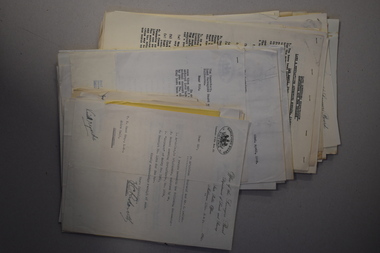
Documents, 1930s,40s,50s,60s
... Documents ...These documents came from the office of Rolf Crawley who was an engineer, surveyor and architect in private practice in Warrnambool and also the engineer for the Shire of Warrnambool from 1935 to 1968. His grandfather, father and uncle were also engineers, working in that capacity for the Shire of Warrnambool or as Secretary for the Shire of Warrnambool, with the Crawley family recording a total of 132 years of service to the Shire. The Shire of Warrnambool existed from 1863 to 1994. The documents came into the possession of Michael Hand who took over the Crawley surveying business in Warrnambool. The Warrnambool and District Historical Society acquired the documents, along with other Crawley memorabilia, from the Michael Hand Estate. These documents will be useful for reference and research, particularly in regard to the Shire of Warrnambool history.This is a packet of documents from the office of Rolf Crawley. They are mostly single sheets which include letters from the Office of the Surveyors Board, documents relating to employees and trainees and some Government papers. They are mostly typewritten with the signature of Rolf Crawley. There is one map of the Eumerella Drainage area.rolf crawley, warrnambool, shire of warrnambool