Showing 8398 items matching "mckillops-bridge"
-
 Lakes Entrance Historical Society
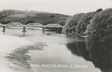
Postcard - Tambo River bridge at Bruthen Victoria, H D Bulmer
Ringbarked trees on hill in background and willows along river bankBlack and white postcard of bridge over the Tambo River at Bruthen Victoria'TAMBO RIVER BRIDGE AT BRUTHEN'agriculture, rivers, bridge -
 Orbost & District Historical Society
display book, 2001-2002
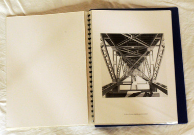
Kevin Parker was born in 1942 in Melbourne and studied Architecture at RMIT and from 1965-1990 worked as a freelance architectural illustrator. He continued this when he moved to Deddick in East Gippsland in 1991. In 2001 -2002 he began working on series of drawings about Mc Killops Bridge and environs for exhibition at Gippsland Art Gallery, Sale Victoria (Oct 2003). These drawings and prints feature McKillop's Bridge an the item is a compilation from a folder usually sold in the Slab Hut (Orbost Visitor Information Centre). A loose-leaf display book of copies of architectural style pencil drawings by Deddick artist, Kevin Parker. There is an introduction by Valerie Auer of Tubbut. The drawings are of McKillop's Bridge.parker-kevin drawings mckillop's-bridge display-book -
 Eltham District Historical Society Inc
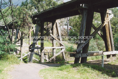
Photograph, Fay Bridge, Eltham Railway Trestle Bridge, n.d
fay bridge collection, eltham, eltham railway trestle bridge, trestle bridge -
 Eltham District Historical Society Inc
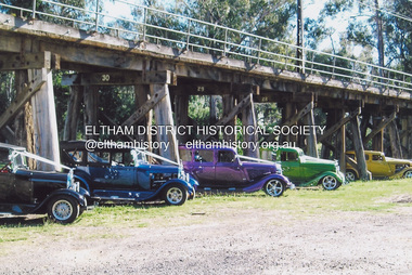
Photograph, Fay Bridge, Hot Rods at the Eltham Railway Trestle Bridge, n.d
fay bridge collection, eltham, eltham railway trestle bridge, trestle bridge, eltham trestle bridge, hot rods -
 Eltham District Historical Society Inc
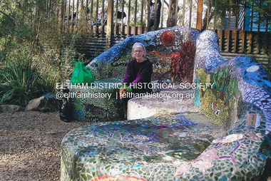
Photograph, Fay Bridge, Fay Bridge with the Lasting Memories Mosaic Seat, St. Andrews Hall, 1 Proctor Street, St. Andrews, n.d
The Lasting Memories Mosaic Group Seat is part of Nillumbik Shire Council's Public Art. Following the Black Saturday Bushfire of February 7, 2009, which ravaged St Andrews and surrounding district, a group of bushfire affected women formed the Lasting Memories Mosaic group and created this concrete seat covered in mosaic as part of their healing process. It was completed in 2012. For more information see Nillumbik Shire Council's link Public Art: Lasting Memories Mosaic GROUP, Lasting Memories Mosaic Seat - https://victoriancollections.net.au/items/58536395d0ce201b746561c6fay bridge collection, fay bridge, mosaics, st andrews, lasting memories mosaic group seat, st andrews hall -
 Eltham District Historical Society Inc
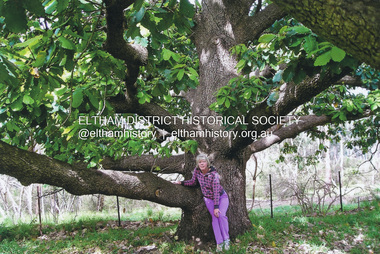
Photograph, Fay Bridge, Fay Bridge with New Zealand Oak at former Morrison property, Killeavey, Laughing Waters Road, Eltham, n.d
Beatrice Wanliss Irvine was the daughter of former Victorian Premier Sir William Irvine. From age 13 she lived at “Killeavey” off Laughing Waters Road (later accessed from Reynolds Road). In 1923 she married James Morrison and the couple received Killeavey as a wedding gift. The property supported fruit and vegetable growing as well as an impressive botanical garden. But James died in 1936 after a period of ill health, leaving Beatrice to support their six children. The Killeavey house was built atop a cliff, 40 metres above the Yarra River. The garden was designed in 1910 by William Guilfoyle who was the second director of the Royal Botanical Gardens. The house was totally destroyed in the Black Friday bushfires in 1939, but was rebuilt. Beatrice continued to live at Killeavey and became well regarded as a botanist and naturalist. She died in 1989 and is buried in Eltham Cemetery with her husband and one of their sons. The (rebuilt) house was demolished by Parks Victoria. It contains significant garden remnants. The surrounding bushland is valued for its significant plant communities.fay bridge collection, beatrice wanliss morrison (nee irvine), eltham, james morrison, killeavey, laughing waters road, william irvine, new zealand oak, fay bridge -
 Eltham District Historical Society Inc
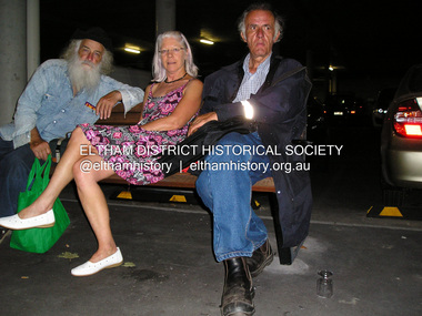
Photograph, Fay Bridge, Maurice Hurry, Fay Bridge and Damian Skipper, 2016
fay bridge collection, damian skipper, eltham town square, fay bridge, maurice hurry, safeway supermarket, 2016 -
 Eltham District Historical Society Inc
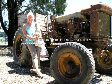
Photograph, Fay Bridge, Fay Bridge with Fordson Tractor at H.Aumann & Sons. Fruit &/or Berry Growers. 246 Tindals Rd, Warrandyte, 29 January 2018
fay bridge collection, 2018-01-29, fay bridge, fordson tractor, h. aumann & sons, warrandyte -
 Ringwood and District Historical Society
Photograph, Mullum Creek from bridge in Warrandyte Rd. Looking East 1970
From bridge in Warrandyte Road. See DB Item 2957 for later photo, same scene, with bridge identified.Typed below photograph, "Mullum Creek 1970 from bridge" -
 Kew Historical Society Inc
Photograph, Outer Circle Railway Viaduct, 1919
Railway Viaduct constructed for the Outer Circle Railway. Bridge designed by John Monash, engineer. Converted into a state highway, 1930s.Dateable photo of an important piece of Victorian railway infrastructure.Photograph of Outer Circle Railway Bridge over River Yarra, Fairfield. Looking toward Lugton Street, showing fence underneath taken from the Chandler Highway. Reverse: "Outer Circle Railway Bridge over River Yarra Fairfield, H0276, Property of Miss Foley"railway viaduct, chandler highway -
 Stawell Historical Society Inc
Painting, Will Rees, Water colour of property at Dadswells Bridge
Property painted was Bill & Jean (Cumming) Howards. They were beekeepers & farmers at Dadswells Bridge. Jeans father was a friend of Will Rees. Audrey's (donor) husband Bob Cummings was raised by the Howards from age of 9.Watercolour Painting by Will Rees Stawell artist. Landscape trees two buildings & sheep. Property at Dadswells Brudge. In brown Frame, reflective glassSigned by Will Reespainting, artwork -
 Kew Historical Society Inc
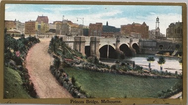
Postcard, Princess Bridge, Melbourne, c.1907
The Kew Historical Society's postcard collection includes views of Kew, Melbourne and Greater Melbourne as well as those including overseas scenes sent or received from Europe or the Middle East. They date from the 1890s to the 2000s. These postcards may or may not include the name of the publisher or printer. A number of the cards were published as parts of popular series. A way of dating early postcards is to identify whether the reverse was divided by a central line which became the norm after 1902 in the United Kingdom. However, other postcards produced after this date do not always conform to this print layout.Rare variant version of this view of Princes Bridge, from the south-east bank of the Yarra River, looking towards the city of Melbourne, showing landmarks of the period.Polychrome postcard of Princess Bridge in Melbourne.Princess Bridge, Melbourne Miss McGilivray, "Oak Bank", Peterborough, _____. princess bridge -- melbourne (vic.), river yarra, postcards -- melbourne (vic.) -
 Kew Historical Society Inc
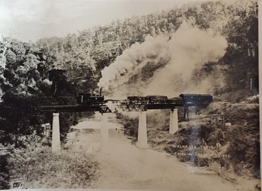
Postcard, Walhalla Train Crossing Thomson Bridge, c.1910
One of a number of 'real photo' and commercial postcards created by or owned by members of the Christian and Washfold families of Kew. The postcards are part of a larger collection of photographs, postcards and publications donated to the collection in May 2021.Small black and white 'real postcard' of the Walhalla Train crossing the Thomson Bridge.Walhalla Train Crossing Thomson Bridgehenry christian (1886-1962), landscape photography, thomson river (vic.), thomson bridge (vic.), trains -- walhalla -- victoria, christian-washfold collection -
 Marysville & District Historical Society
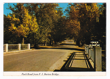
Postcard (item) - Colour postcard, Nucolorvue Productions Pty. Ltd, Pack Road from F.J. Barton Bridge, Pre 2009
A colour photograph of Murchison Street from the F.J. Barton Bridge in Marysville in Victoria.A colour photograph of Pack Road from the F.J. Barton Bridge in Marysville in Victoria. Labeling is incorrect. The view is looking down Murchison Street from the F.J. Barton Bridge. The F.J. Barton Bridge was named after Frederick John Barton. The Barton Family were amongst Marysville's first pioneering families. This postcard was published by Nucolorvue Productions as a souvenir of Marysville.NU-COLOR-VUE/ OF / AUSTRALIA MARYSVILLE, VICTORIA. Pack Road from F.J. BARTON/ BRIDGE. PLACE/ STAMP/ HERE POST CARD NCV.172 - NUCOLORVUE PRODUCTIONS PTY. LTD./ COPYRIGHT Printed in Australia (Note our new/ bridge) Hullo Dot,/ Very pleased to/ have the chance to meet someone who/ can tell us your news. All the best from/ all the family here at Marysville/ Terry. Dear Dot,/ Good to hear/ first hand news/ of you. Regards,/ Elsie Walkermarysville, f.j. barton bridge, murchison street, victoria, postcard, souvenir, nucolorvue productions, fj barton -
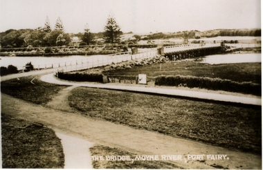
 Port Fairy Historical Society Museum and Archives
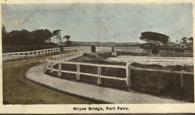
Photograph - Postcard, Moyne bridge
Photograph hand tinted of the Moyne river road bridge taken from Gipps Street showing house on the far bank on the right side taken for use as a PostcardMoyne Bridgemoyne bridge 1910, moyne river, traffic, gipps street -
 Chelsea & District Historical Society Inc
Photograph - Patterson River, Rail and Road Bridge, Carrum
The first bridge over the river was built in the early 1880's, prior to this it was a pontoon bridge. In 1927 a concrete bridge was built to replace the wooden bridge.Black and white photo of Patterson River, looking east from the Port Phillip Bay. PATTERSON RRIVER BRIDGE, CARRUMpatterson river, chelsea, patterson river bridge, carrum bridge, canoes, beach, leisure -
 Mt Dandenong & District Historical Society Inc.
Photograph, Barber's Bridge on Olinda Creek
John Lundy-Clarke grew up in the Kalorama/Mt Dandenong area and later in life (1972-74) began to write a comprehensive history of the area working from an original settlement map in an effort to cover all areas. Barbers Bridge was named after George Barber, an early settler.Black and white photograph showing a man standing on a bridge over the Olinda Creek. 1910Handwritten n reverse: Barbers Bridge on Olinda Creek 1910. This was a ford crossed by the road after Isaac Jeeves selected allotment “C” “Jeeves Saddle” in 1871 and stopped travel through his property. The bridge has been built several times but at time of writing (1974) is replaced by a culvert consisting of two pipes two feet six inches wide. They are quite incapable of carrying the maximum flow of the creek and will be swept away.lundy-clarke, barber, barbers bridge, isaac jeeves, jeeves saddle, bridge, olinda creek -
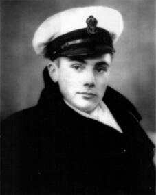 Waverley RSL Sub Branch
Photo, 36953 s/a (v) McKillop H.M.A.S. Commonwealth Kure Japan
Black and white photo of Barry McKillop (BCOF RAN) Kure Japan.see item d/025536953 s/a (v) McKillop H.M.A.S. Commonwealth Kure Japan -
 Ringwood RSL Sub-Branch
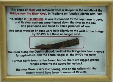
Souvenir Framed item, Piece of bridge from the Burma Railway, C 1987
Wooden frame with text and a piece of teak from the Bridge over the River Kwai.Collected from the bridge on 10th March 1987. -
 Marysville & District Historical Society
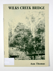
Book, Wilks Creek Bridge, 1993
A history of the Wilks Creek Bridge and its connection to the Yarra TrackPaperback. Front cover has an old photograph of the Wilks Creek Bridge.Dear Reader, The pen has only to select one of the many stages of building old Yarra Track,/ for a colorful story subject. The Track, first established in the early 1860's to/ serve goldseekers making their hazardous way to the rich Wood's Point goldfields,/ extended some 160km from Eltham - in Melbourne's northern region to Woods/ Point in the eastern ranges. I hope a glimmer of the excitement of those times comes through as I draw/ your attention to old Wilks Creek bridge and its picnic spot to be found 3.5km/ west of Marysville. Once part of Yarra Track and now superseded by a modern/ roadway alongside, the old bridge with its solid masonry walls either side of the/ cold, pure stream makes a pleasing scene for the visitor. With much pleasure/ I dedicate this narrative to Marysville and District Historical Society./ Ann Thomas Stamp of Marysville & District / Historical Society Inc / P.O. Box 22 / Marysville 3779wilks creek, marysville, yarra track, victoria, history, local history -
 Stawell Historical Society Inc
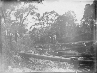
Photograph, Bridge Building -- Possibly Delley's Bridge c1901
Photo of 3 women with a dog standing on a bridge with 5 men possible working on the Bridge in the Grampians. Photo taken in the area where Delley’s Bridge now stands, Hall’s Gap. c1901Sepia Post Card depiction people around a log bridge over a waterway in bush setting.Post Cardstawell -
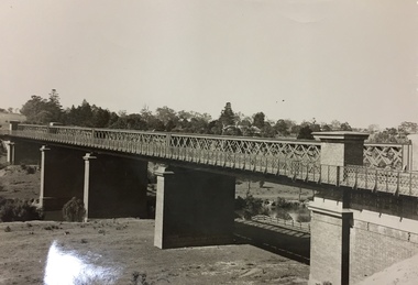
 Ballarat Heritage Services
Photograph - Photograph - Colour, Clare Gervasoni, Nimon's Bridge, 1999, 04/10/1999
Nimons Bridge was built in 1890, as part of the then Ballarat-Linton railway. The bridge is 17 spans with tall timber piers of four driven piles each, with triple sets of diagonal cross-bracing and walers and a single row of longitudinal horizontal bracing between piers. The spans are of a uniform twenty feet (6.1 metres), originally supported by four 21-inch x 9-inch (535 mm x 230 mm) Kauri timber beams per span, following the standard V.R. design of the period. When the superstructure was rebuilt after the 1953 fire, the timber beams were replaced with two 24-inch (610mm) deep rolled-steel-joists on each span. These are marked 'Lancashire Steel Co., Scotland' and are believed to have been second-hand. The deck of transverse-timber planks is 103.6 metres in length. Overall the bridge has an impressive appearance with its exceptionally tall triple-cross-braced piers creating a 'three-tiered' effect, with the deck 19.2 metres above the Woady Yaloak River. The Ballarat-Skipton line closed in 1985. Nimons Bridge has been recently restored, as part of the Ballarat-Skipton Rail Trail. How is it significant? Nimons Bridge is significant for technical, historic and aesthetic reasons at a State level. Why is it significant? Nimons Bridge is technically significant as Victoria's fourth-tallest timber trestle bridge when built, and as the third-tallest surviving example. It is also the second-largest composite bridge combining traditional timber piers with RSJ spans and a timber deck and falls within a select group of fewer than ten timber railway bridges with horizontal longitudinal bracing between the piers and three sets of double cross-bracing on its tallest piers, creating a visually striking 'three tiered' effect that enhances its viaduct form. Nimons Bridge is historically significant as having served initially the mining community at Linton, then the Western District agricultural area and in later years a kaolin quarry at Pittong. Nimons Bridge is historically significant as a representative of the 'light' branch line methodology that stimulated the explosion of railway construction in Victoria during the 1880s, and provides an interesting contrast with the more solid and vastly more expensive railway viaducts built in similar terrain on Victorian main lines, at Moorabool and Taradale, in the late 1850s. Approached by a deep cutting and high embankment at either end, the bridge represents a very cost-effective late 19th century engineering solution to the characteristic physiography of western Victoria with flat basalt plains intersected by deep wide valleys occasionally subject to severe flooding. Nimons Bridge is aesthetically significant for its visually impressive viaduct form, crossing a deep and steep-sided valley that is part of a rich cultural landscape. Within close proximity of the bridge are mullock dumps, tailings, shaft sites and other relics of the deep-lead alluvial mining era. The bridge is the most visually spectacular timber-trestle rail bridge in Western Victoria and is among the most spectacular timber-trestle rail bridges surviving anywhere in Victoria. It is part of the Ballarat-Skipton Rail Trail. Classified by the National Trust :02/10/2000 (http://vhd.heritagecouncil.vic.gov.au/places/67986)Colour photograph of a log bridge known as Nimon's Bridge.ballarat-linton, nimons bridge, nimon's bridge, log bridge, viaduct, timber-trestle rail bridge -
 Phillip Island and District Historical Society Inc.
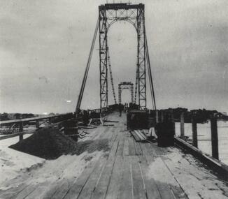
Photograph, Suspension Bridge, 1939 - 40
Suspension Bridge completed in 1940 and opened by Hon. Albert Dunstan MLA, Premier of Victoria. First Phillip Island Bridge under constructionPhillip Island Suspension Bridge taken along length of bridge - under constructionlocal history, photographs, bridges, phillip island - suspension bridge, black & white photograph, jack jenner, phillip island bridges -
 Phillip Island and District Historical Society Inc.
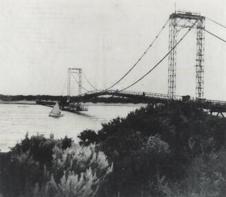
Photograph, Suspension Bridge, 1940's
Phillip Island Suspension Bridge, showing workmen bridge. Bridge completed 1940 and opened by Hon. Albert Dunstan MLA, Premier of Victoria.Phillip Island Suspension Bridge taken from San Remo shoreline with sailing boat underneath and workmen on bridgelocal history, photographs, civil engineering, bridges, phillip island suspension bridge, black & white photograph, jack jenner collection, phillip island bridges, public construction -
 Linton and District Historical Society Inc
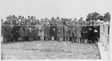
Photograph, Opening of Bridge over Woady Yaloak Creek, between Linton and Scarsdale, 1928, 1928
Black and white photograph of a crowd of men, women and children standing behind a ribbon stretched between sets of bridge rails."Opening of bridge between Linton and Scarsdale".events, bridge openings, woady yaloak creek, faull collection -
 Stawell Historical Society Inc
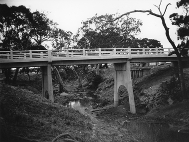
Photograph, Greens Creek Bridge on the Wimmera River 1929
Greens Creek Bridge on the Wimmera River built in 1929 by C.R.B. and now demolished. The replacement bridge was designed to cope with the floods and the approaches to the new bridge were built up. This photo is a copy of a negative owned by the society.Black and white photograph of a concrete road bridge over a creek. Red gum trees in the background. Two concrete supports remain of old bridge on bank behind new bridge.stawell -
 Port Fairy Historical Society Museum and Archives
Postcard, Valentine Publishing Co, The Bridge Moyne River Pt Fairy, 10.04.1929
Black and white Photograph of the bridge crossing the Moyne river with Gipps street in the foreground cleared land in the background taken for use as a postcardThe Bridge Moyne River Pt Fairymoyne bridge circa 1930, bridge, moyne river, river, road -
![The Fairfield Bridge [circa 1891]](/media/collectors/550653872162f11fb04854aa/items/579eab98d0cdd117c4af1c89/item-media/579eac23d0cdd117c4afb1ad/item-fit-380x285.jpg) Kew Historical Society Inc
Kew Historical Society IncPrint, The Fairfield Bridge [circa 1891], c. 1891
This work forms part of the collection assembled by the historian Dorothy Rogers, that was donated to the Kew Historical Society by her son John Rogers in 2015. The manuscripts, photographs, maps, and documents were sourced by her from both family and local collections or produced as references for her print publications. Many were directly used by Rogers in writing ‘Lovely Old Homes of Kew’ (1961) and 'A History of Kew' (1973), or the numerous articles on local history that she produced for suburban newspapers. Most of the photographs in the collection include detailed annotations in her hand. The Rogers Collection provides a comprehensive insight into the working habits of a historian in the 1960s and 1970s. Together it forms the largest privately-donated collection within the archives of the Kew Historical Society.A reproduction of a photograph of the Fairfield Bridge. The bridge was one of the first constructed for the Outer Circle Railway in 1891. Its supervising engineer was [Sir] John Monash. The bridge was later to be repurposed as a road linking the Chandler Highway to Fairfield."Outer Circle Railway Bridge over River Yarra at Fairfield (last section of line opened 1891)"fairfield bridge, chandler highway bridge, dorothy rogers, john monash, outer circle railway -
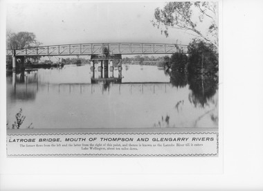 Lakes Entrance Historical Society
Photograph, Caire, Nicholas John, Swing Bridge Sale Victoria, 1905c
turning on a central axis to allow the passage of river vessels. Image shows machinery for operation and the bridge closed to river traffic. Latrobe Wharf on the left bank is seen through bridge. Sale VictoriaBlack and white photograph of the Latrobe Bridge. This was a swing bridge over the Latrobe Riverbridges, waterways, civil engineering, jetties -
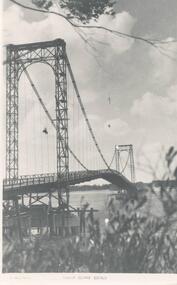 Phillip Island and District Historical Society Inc.
Photograph, Suspension Bridge, 1940's
Donated by John JanssonBlack & White photograph of the San Remo to Newhaven Bridge taken from San Remo in foreground to Newhaven in background."Photo Shop Series" "Phillip Island Bridge"phillip island bridge, john jansson