Showing 74 items
matching mines sea mines
-
 Flagstaff Hill Maritime Museum and Village
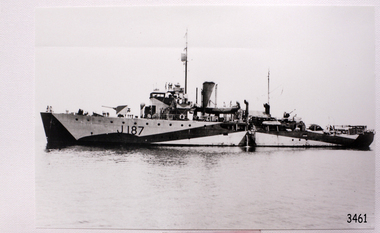
Photograph - Vessel, Steam Ship, H.M.A.S. Bendigo J187, post WWII
... sea mine patrol... Sydney built ship sea mine patrol Mine sweeper Mine clearance ...This photograph depicts the Royal Australian Navy's ship HMAS Bendigo (J187), one of 30 sips commissioned by the RAN for defence purposes in World War II. The ship was named after the City of Bendigo in Victoria. The corvette ship was a Bathurst class minesweeper, built by Cockatoo Docks and Engineering Company, at Cockatoo Island, Sydney. The ship was launched in March 1941, commissioned May 1941, decommissioned September 1946, and sold to a Chinese company as a civilian vessel.This photograph is significant for its association with the Royal Australian Navy and Australia's maritime and naval history. Black and white photograph of steamship H.M.A.S. Bendigo,, Bathurst class minesweeper J187.flagstaff hill, maritime village, maritime museum, warrnambool, shipwreck coast, cockatoo docks and engineering company, h.m.a.s. bendigo, hmas bendigo, hmas bendigo i, j187, world war ii, bathurst class corvette, royal australian navy, sydney built ship, sea mine patrol, mine sweeper, mine clearance, photograph, maritime photograph, minesweeper -
 Bendigo Historical Society Inc.
Document - GARDEN GULLY LINE OF REEF
Handwritten document . 'The Garden Gully line of reef, south to north, main shafts only' Great Southern, first important mine 1876 - 1924 Ulster United Londonderry shaft The Sea Amalgamated Garden Gully United 'Bendigo's most famous mine' 1874 - 1921 Victory and Pandora Ironbark 1871 - 1921 Unity Mine Carlisle United Long Gully ' Bendigo's richest mine' Cornish United 1866 - 1920 Koch's pioneer Windmill Hill 1874 - 1920 Confidence Extended 1877 - 1896 - 1915 Johnson's Group California Gully No. 1 and No. 2 and No. 3 Derby line North Johnson's Princess Dagmar 1876 - 1918 Golden Age 1870 - 1917 Johnson's Reef Extended Golden Pyke 1870 - 1921 Constellation 1887 - 1923 Great Northern 1877 - 1922 Virginia 1878 - 1922 Specimen Hill United 1860 - 1920 New Argus 1864 - 1922 Clarence United Sailors Gully 1857 - 1918 South New Moon 1871-1920's and 1933 - 1941 New Moon 1868 - 1922 - 1931 Suffolk United 1870 - 1918 North New Moon 1894 - 1924Albert Richardsonbendigo, mining, garden gully line of reef mines -
 Bendigo Historical Society Inc.
Document - GARDEN GULLY LINE OF REEF, LEASE BLOCKS 5360 AND 5361
Two page document titled ' Report on lease blocks Nos. 5360 and 5361 Garden Gully line of reef, Bendigo. Produced by the Department of Mines 1899. The area described is about 'one mile and a quarter southeast from the centre of the city of Bendigo, immediately south of the Great Southern Gold Mining Company's workings and is intersected by two auriferous gullies ... Salomon's Gully and Derwenter's Gully'. The alluvial deposits, the Garden Gully line, the Great Souther Co.and old workings are discussed in the paper. A map of the Garden Gully line of reef is attached to the report, showing claimholders and mine names along that section of the reef. Mines named on the map: Great Southern Garden Gully United Ulster Londonderry Burrows Horwoods Sea Amalgamated Garden Gully United Victory and Pandora Unity Carlisle and Garden Gully and Passbye United Cornish United Koch's PioneerJames Stirling, Government Geologistbendigo, mining, garden gully line of reef mines -
 National Vietnam Veterans Museum (NVVM)
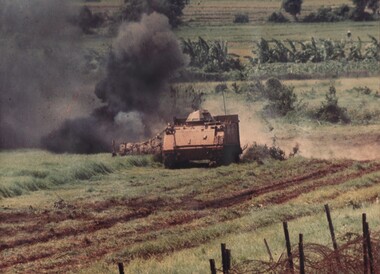
Photograph, Gibbons, Denis, Barrier Minefield
Denis Gibbons (1937 – 2011) Trained with the Australian Army, before travelling to Vietnam in January 1966, Denis stayed with the 1st Australian Task Force in Nui Dat working as a photographer. For almost five years Gibbons toured with nine Australian infantry battalions, posting compelling war images from within many combat zones before being flown out in late November 1970 after sustaining injuries. The images held within the National Vietnam Veterans Museum make up the Gibbons Collection.A coloured Photograph of a specially constructed 'up armoured' Armoured Personnel Carrier (APC) being used to explode anti personnel mines buried in the 'Barrier' minefield from the village of Dat Do to the sea, Phuoc Tuy Province, South Vietnam. Each driver only spent and hour in the APC.photograph, apc, 3rd cavalry regiment, dat do, phuoc tuy province, gibbons collection catalogue, armoured personnel carrier, mine "anit-personnell m18a1, denis gibbons -
 Bendigo Historical Society Inc.
Document - LONG GULLY HISTORY GROUP COLLECTION: EDWARD CLARENCE DYASON
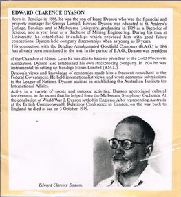
Edward Clarence Dyason was born in Bendigo in 1886, the son of Isaac Dyason who was the financial and property manager for George Lansell. After World Was 2, he settled in England. He represented Australia at the British Commonwealth Relations Conference in Canada, on the way back to England he died at sea on 3 October 1949. Printed obituary with black and white photo of Edward Clarence Dyason. Printed article mounted on yellow card which is mounted on purple card and laminated.bendigo, history, long gully history group, the long gully history group - edward clarence dyason, isaac dyason, george lansell, st andrew's college bendigo, melbourne university, bendigo amalgamated goldfield company (b. a. g.), chamber of mines, gold producers association, bendigo mines limited (b.m.l.), league of nations, australian institute for international affairs, melbourne symphony orchestra, british commonwealth relations conference -
 Bendigo Historical Society Inc.
Map - HUSTLERS LINE OF REEFS - LONGITUDINAL SECTION THROUGH THE SADDLE REEFS
Drawing with Longitudinal Section through the Saddle Reefs along portion of Hustler's Line of Reefs, Bendigo. Map shows the depth of the mines, reef numbers and Datum 700 ft above sea level. North and South is also noted on the map. Map signed by H. S, Whitelaw, Underground Survey Office, Bendigo, September 1913. Bulletin No 33, Plate No XXXIV. Bendigo Creek, Ironbark Creek and Long Gully are also noted. Mines are: Fortuna Hustlers, Hustler's Royal Reserve No 2 Main Shaft, Hustler's Royal Reserve No 2 Park Shaft, Royal Hustler's, Imperial Hustler's, Extended Hustler's Freehold, Great Extended Hustler's Tribute (Pups), Old Shaft, Great Extended Hustler's Reef No 2, Great Extended Hustler's Main Shaft, Old Shaft, Hustler's Reef, Hustler's Reef No 1, Comet, K. K., United Hustler's & Redan, Old Shaft and Hustler's Consols. Has Geological Survey of Victoria Crest and underneath is: H. Herman, Director, W. Dickson, Secretary for Mines, The Hon. J Drysdale Brown M L C. Minister of Mines.Geological Survey of Victoria Crestmining, hustler's reef maps, hustlers line of reefs, bendigo creek, royal hustler's, imperial hustler's, extended hustler's freehold, great extended hustler's tribute (pups), great extended hustler's reef no 2, great extended hustler's main shaft, hustler's reef, hustler's reef no 1, united hustler's & redan, old shaft and hustler's consols.h s whitelaw, underground survey office bendigo september 1913 -
 Bendigo Historical Society Inc.
Map - HUSTLER'S REEF NO 1 MINE - TRANSVERSE SECTION OF THE HUSTLER'S REEF NO 1 MINE
Map of a transverse Section of the Hustler's Reef No 1 Mine on the hustler's Line of Reefs Bulletin No 33, Plate No XXI. Map shows poppet legs at 801.07 feet above Sea Level and drawing of shaft with the different levels. Also shown are geological features and stone encountered. Geological Survey of Victoria emblem H Herman, Director, W Dickson, Secretary of Mines and The Hon. J. Drysdale Brown MLC Minister of Mines. Signed by H S Whitelaw, Underground Survey Office Bendigo, September 1913. This item has not been scanned or photographed.mining, parish map, hustler's reef no 1 mine, hustler's line of reefs, geological survey of victoria, underground survey office bendigo, h s whitelaw, h herman, w dickson, the hon j drysdale brown -
 Bendigo Historical Society Inc.
Map - HUSTLER'S ROYAL RESERVE NO 2 CO. - LONGITUDINAL SECTION OF THE HUSTLER'S ROYAL RESERVE NO 2 CO
Longitudinal Section of the Hustler's Royal Reserve No 2 Co. on the Hustler's Line of Reef Bulletin No 33, Plate No VIII. Note - Plates 4, 8, 13, 20, 26 & 31 form a Longitudinal Section from Fortuna Hustler's to Hustler's Consols Mine. Mines mentioned are the Hustler's Royal Reserve No 2 Main Shaft, Hustler's Royal Reserve No 2 Park Shaft, Royal Hustler's, Imperial Hustler's, Great Extended Hustler's Freehold and the Great Extended. Section shows depth of levels, datum lines and height of sill above sea level yield in oz. of gold. Geological Survey of Victoria emblem. H. Herman, Director, W. Dickson, Secretary for Mines and The Hon. J. Drysdale Brown MLC, Minister for Mines and signed by H S Whitelaw, Underground Survey Office Bendigo, September 1913. mining, parish map, hustler's royal reserve no 2, royal hustler's, imperial hustler's, great extended hustler's freehold, great extended, geological survey of victoria, underground survey office bendigo, h s whitelaw, h herman, w dickson, the hon j drysdale brown -
 Bendigo Historical Society Inc.
Map - HUSTLER'S ROYAL RESERVE NO 2 CO - TRANSVERSE SECTION OF THE HUSTLER'S ROYAL RESERVE NO 2 CO
Transverse Section of the Hustler's Royal Reserve No 2 Co Mine on the Hustler's Line of Reef Bendigo, Bulletin No 33, Plate No VII. Section shows the poppet legs and the sill of Shaft at 707.65 ft above sea level, depth of levels, stone encountered and geological features. Geological Survey of Victoria emblem. H. Herman Director, W. Dickson Secretary of Mines and The Hon. J. Drysdale Brown MLC, Minister of Mines. Signed by H S Whitelaw, Underground Survey Office Bendigo, September 1913. mining, parish map, hustler's royal reserve no 2 co, h s whitelaw, undergrou;nd survey office bendigo, geological survey of victoria, h herman, w dickson, the hon. j drysdale brown mlc -
 Bendigo Historical Society Inc.
Map - HUSTLER'S ROYAL RESERVE NO 2 (PARK SHAFT.) - TRANSVERSE SECTION OF THE HUSTLER'S ROYAL RESERVE NO 2
Transverse section of the Hustler's Royal Reserve, No 2 (Park Shaft.) on the Hustler's Line of Reef. Bulletin No 33, Plate No IX. Section shows poppet legs and sill of shaft at 755.70 ft above sea level, depth of levels, type of stone encountered including lava and geological features. Geological Survey of Victoria emblem and beneath it H. Herman, Director, W. Dickson, Secretary of Mines and The Hon. J. Drysdale Brown MLC Minister of Mines and signed by H S Whitelaw, Underground Survey Office, Bendigo September 1913.mining, parish map, hustler's royal reserve no 2 (park shaft.), h s whitelaw, underground survey office bendigo, geological survey of victoria, h herman, w dickson, the hon j drysdale brown mlc, hustler's line of reef -
 Bendigo Historical Society Inc.
Map - UNITED HUSTLER'S & REDAN & K. K. MINES - PLAN OF THE UNITED HUSTLER'S & REDAN & K. K. MINES
... . Sill of shaft of the K. K. Mine 773.56 ft above Sea Level... Mine 745.62 above Sea Level. Also mentioned is the average ...Plan of the United Hustler's & Redan & K. K. Mines Bulletin No 33 Plate No XXXI. Shows depth of levels, Probable positions of reefs and natural surface with the poppet legs at the two shafts. Sill of shaft of the K. K. Mine 773.56 ft above Sea Level and sill of shaft of the United Hustler's & Redan Mine 745.62 above Sea Level. Also mentioned is the average amount of gold obtained per ton. Note on the top of page - Plates 4, 8, 13, 20, 26 & 31 form a Longitudinal Section from Fortuna Hustler's to Hustler's Consols Mine. Geological Survey of Victoria emblem and signed by H S Whitelaw, Underground Survey Office, Bendigo, September 1913. mining, parish map, united hustler's & redan & k. k. mines, geological survey of victoria, h s whitelaw, underground survey office bendigo -
 Bendigo Historical Society Inc.
Map - UNITED HUSTLER'S & REDAN MINE - TRANSVERSE SECTION UNITED HUSTLER'S & REDAN MINE
Transverse Section of the United Hustler's & Redan Mine on the Hustler's Line of Reefs Bulletin No 33, Plate No XXIX. Map has drawing of poppet legs on the surface, depth of levels, type of stone encountered and some geological features. Sill of shaft 745.62 ft above sea level. Map has Geological Survey of Victoria emblem and signed by H S Whitelaw, Underground Survey Office Bendigo, 'September 1913. mining, parish map, united hustler's & redan mine, hustler's line of reef, geological survey of victoria, h s whitelaw -
 Bendigo Historical Society Inc.
Map - K. K. MINE - TRANSVERSE SECTION K. K. MINE
Transverse Section of the K. K. Mine on the Hustler's Line of Reefs, Bulletin No 33, Plate No XXXII. Map shows the different levels and their depth. Also, the different types of stone encountered and geological features such as spurs and faults. Has drawing of the poppet legs at the top of the shaft and sill of shaft 773.56 ft above sea level. Map has Geological Survey of Victoria crest and signed by H S Whitelaw, Underground Survey Office Bendigo, September 1913. miners, fortuna hustler's mine, transverse section of k. k. mine, hustler's line of reefs, geological survey of victoria, h s whitelaw -
 Bendigo Historical Society Inc.
Document - NEW CHUM & VICTORIA LINES OF REEF - NOTES ON JOHNSON'S REEF
Handwritten notes mention 'History of Bendigo by G Mackay, St Mungo Line of Reef from the Belmont Mine, Princess Alexander Shaft, Johnson's no 1 Mine, North Johnson's with notes on buildings, etc. and date 22/9/1892, and the Johnson's Reef Extended dated 29/10/1892, with note on building, mullock heap, and sill 779.18 above sea level. Also mentioned are Leo Chapman and Tom Sayers.document, gold, new chum & victoria lines of reef, notes on johnson's reef, history of bendigo, g mackay, mines' dept, st mungo line of reef, e j dunn report 21/10/92, princess alexander shaft, united devonshire shaft, johnson's reef, garden gully line, johnson's no 1 mine, north johnson's, e j dunn's report 29/10/1892, johnson's reef extended, leo chapman, tom sayers