Showing 72 items
matching municipal boundaries
-
 Port Melbourne Historical & Preservation Society
Document - Electoral Roll, City of Port Melbourne, Boundary Ward, City of Port Melbourne, Voters' Rolls, 1983
Prepared by the Town clerk's office. Voters Roll for City of Port Melbourne's Boundary Ward: list of electors entitled to be enrolled on Municipal Clerk's rolls.Voters' Rolls 1983/84 City of Port Melbourne, Electoral Province of Melbourne, Port Melbourne Division Sandridge Ward - List of electors entitled to be enrolled on Municipal Clerks' Rolls @ 29 July 1983.local government - city of port melbourne, town clerks, frederick charles jackson -
 Ballarat Heritage Services
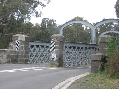
Photograph, Redesdale Bridge, 2016, 18/01/2016
... municipal boundary... of metcalfe bridge municipal boundary shire of mcivor redesdale bridge ...The Redesdale Bridge is a wrought iron and timber structure with bluestone abutments which was installed over the Campaspe River in January 1868, although the bridge actually bears the date 1867. In 1859, the "Herald of the Morning", a ship carrying a cargo including 350 tons of ironwork for the Hawthorn bridge, caught fire and was scuttled a quarter of a mile off the jetty at Sandridge. A Melbourne salvaging firm raised the ironwork from the bottom of the bay, but after details of an arranged sale to the government caused a scandal in Parliament, the material was sold privately to the Melbourne foundry Langlands & Co. Two hundred tons of it was sold to the goldfields shires of McIvor and Metcalfe for only £1000. The bridge was designed by engineer T.B. Muntz and built by a contractor named Doran, and was completed late and considerably over budget at £6274. The bridge spans 45.7m across the river and has two roadways which are carried between three metal lattice girders in a through truss configuration. The design for the Hawthorn bridge had the deck supported over the trusses, and to stiffen the through truss configuration three sets of distinctive paired arches connect the trusses above the roadways. The roadway decking is constructed of longitudinally placed timbers on timber cross girders which rest on the lower chords of the trusses. (Heritage Victoria) A number of colour photographs showing the historic bridge at Metcalfe.metcalfe, shire of metcalfe, bridge, municipal boundary, shire of mcivor, redesdale bridge, campaspe river, t.b. muntz, doran -
Southern Sherbrooke Historical Society Inc.
Information folder - Local Government Amalgamations 1986, 1985 & 1986
Folder containing information pertaining to the Local Government amalgamations in Victoria in 1986. Contents: -copy of "Local Government Act 1958, appointment of a division of the local government commission and referral of proposals to the division", 8 pages and 6 explanatory maps -memo, dated 21 November 1985 from K. E. Matson, General Manager, Shire of Sherbrooke, to all councillors, re. local government commission and municipal restructure, 12 pages including map -letter, Warwick Heine, CEO, Shire of Lilydale to K. E. Matson, General Manager, Shire of Sherbrooke, dated 16 April 1986, re. local government restructure (2 copies) -booklet, "The Restructure of Local Government in Victoria: Options Paper Eastern Melbourne Segment", Local Government Commission June 1986, 24 pages -article "Residents to fight land deal", Knox-Sherbrooke News, 17 June1986, re. proposed annexation of part of Lysterfield by Berwick Council -article "Knox and Sherbooke align for the future", The Trader, 30 April 1986, re. alignment of common boundary -article "Boundary changes 'just a joke'", by Cheryl Critchley, Knox-Sherbrooke News, 6 May 1986 , re. Knox-Sherbrooke boundary alignment -article "Border clash worsens", by Peter Janky, Mountain District Free Press, 7 May 1986, re. Sherbrooke-Lilydale boundary changes -article "Ranges future is still clouded", The Free Press 30 April 1986, re. proposal to form a shire covering Dandenong Ranges -article "Sherbrooke wins first battle in restructuring", by Peter Janky, Free Press, 30 April 1986, re. ceding of forest areas by Knox to Sherbrooke.shire of sherbrooke, shire of lilydale, knox city council, berwick shire council -
 Ballarat Tramway Museum
Map, Electric Supply Co. of Vic (ESCo), Ballarat Electoral Map - ESCo, 1900
Document prepared by the Electric Supply Co of Victoria, as part of an order under the Electric Light and Power Act 1896, section 5 of order No. 17 granted to company. Dated 19/2/1901 and signed by the Postmaster-General. Shows the order area being parts of the City of Ballaarat, Sebastopol and Ballarat East. Shows the street names, boundaries, principal power line routes, land reserves, parks, mine locations, railways and Lake Wendouree. Signed by R L Williams Town Clerk City of Ballarat, J R Hall for the Borough of Sebastopol, and John Gent for the Town of Ballarat EastYields information about the power supply to the Ballarat area.Cloth backed paper map, coloured and marked up as exhibit 17.Notes in ink including the signature of Benjamin Deakin 24/9/00 and certified by the three involved municipal Town Clerks.ballarat power supply, esco, electric supply co of victoria, city of ballaarat, east ballarat, sebastopol, orders, power lines, power supply -
 Kew Historical Society Inc
Legal record - The Indenture, Crown Portion 86, otherwise known as 'The Morgan Deed', 1852 (and later)
This indenture once formed part of the City of Kew's Municipal Collection. Cr. W.D. Vaughan in his history 'Kew's Civic Century' (1960) records on page 194 that: "The original deed of conveyance of the land being all of Crown Portion 86, Kew, purchased by John Quick, James Venn Morgan, Samuel Derrick and William Derrick was presented by the Historical Society of Victoria on behalf of Mrs Fryer, a daughter of the later J.V. Morgan, to the [Kew] Council on August 5, 1941. Crown Portion 86, comprised all the land between Cotham Road and High Street to an alignment opposite the east boundary of Glenferrie Road. On it the first residential house was built by Mr. J.V. Morgan in 1852." Following the donation, the Indenture was surrounded by other original related text and explanatory notes and framed. The resulting framed documents are the largest framed objects in the collection.The Indenture and the accompanying contextual documents are some of the most historically significant manuscripts to have survived since the settlement of Kew in the 1850s. They provide a link to Kew's most famous pioneering families.Framed 1952 Indenture recording the sale of land in Kew to pioneering Kew families.james venn morgan, john quick, william derrick, samuel derrick, kew (vic) - history, kew (vic) - pioneers, samuel watts, kew (vic.) — municipal collection -
Kew Historical Society Inc
Journal, Kewriosity : July 1993
... . Recreation Centre Extension / p1. Chief Executive's Column [Municipal ...Thank you to the volunteers of Kew / p1. Recreation Centre Extension / p1. Chief Executive's Column [Municipal boundaries] / p2&3. Mayor's Comment / Cr Roger Streeton p3. Diary Dates [July - August 1993] / p4. Main Street comes to Kew / p5. Scholarships bring success to Kew High School / p5. Explore worlds through a book / p5. Council News [Mayor's Winter Concert; Kindergarten open days; Council elections; Davis St Kindergarten; Death cap mushrooms] / p6. Around Kew [Kew Community House; Citizen's Advice Bureau; Working to help mothers; Over 50's water exercises; CAA book fair; New computers for Trinity Grammar] / p7. Weekly collection of mobile garbage tins begins from 19 July / p8.Kewriosity was a local newsletter combining Kew Council and community news. It was published between November 1983 and June 1994, replacing an earlier Kewriosity [broad] Sheet (1979-84). In producing Kewriosity, Council aimed to provide a range of interesting and informative articles covering its deliberations and decision making, together with items of general interest and importance to the Kew community and information not generally available through daily media outlets.non-fictionThank you to the volunteers of Kew / p1. Recreation Centre Extension / p1. Chief Executive's Column [Municipal boundaries] / p2&3. Mayor's Comment / Cr Roger Streeton p3. Diary Dates [July - August 1993] / p4. Main Street comes to Kew / p5. Scholarships bring success to Kew High School / p5. Explore worlds through a book / p5. Council News [Mayor's Winter Concert; Kindergarten open days; Council elections; Davis St Kindergarten; Death cap mushrooms] / p6. Around Kew [Kew Community House; Citizen's Advice Bureau; Working to help mothers; Over 50's water exercises; CAA book fair; New computers for Trinity Grammar] / p7. Weekly collection of mobile garbage tins begins from 19 July / p8.publications -- city of kew (vic.), kewriosity, council newsletters, community newsletters -
 City of Greater Bendigo - Civic Collection
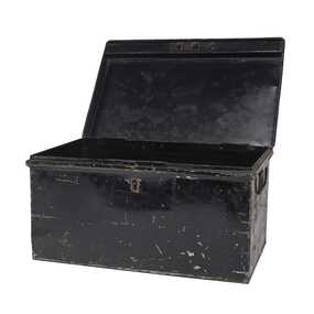
Functional object - Metal Box, Unknown
The first local government authority for Marong was the Marong Road District (an early form of single-purpose local government), which was proclaimed on 19 August 1860. Its boundary was altered twice in 1862 and on 12 December 1864 it was re designated as a Shire. It absorbed Raywood Borough in 1915, and was proclaimed a Rural City in 1990. On 2 December 1994, with the creation of Greater Bendigo City Council, it was abolished by being amalgamated with Bendigo City, Eaglehawk Borough, Huntly Shire, part of McIvor Shire, part of Metcalfe Shire and Strathfieldsaye Shire to form the City of Greater Bendigo. This metal box contained a roll of admission tickets and was possibly used for holding cash at the swimming pool or other municipal facility. Lockable painted metal box. Shire of Marongshire of marong -
 Eltham District Historical Society Inc
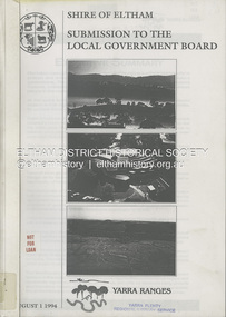
Book, Shire of Eltham, Submission to the Local Government Board: Yarra Ranges, 1 August 1994
A restructure proposal by the Shire of Eltham, named the municipality of Yarra Ranges, reflects a strategic focus. It has natural boundaries and a strong sense of place built on communities of interest. Prepared in consultation with the community and neigbouring municipalities of Diamond Valley and Heidelberg. Contents include: Principles for change, rationale for the proposal, mergers and other restructure proposals. Appendices include: community consultation, Metropolitan Green Wedge Strategy, Constituent Council Benchmark, external refernce benchmark - Moreland, communities of interest, conservation and landcare groups, social profile, key financial management strategies and more.54 pages, 11 Appendicesnon-fictionA restructure proposal by the Shire of Eltham, named the municipality of Yarra Ranges, reflects a strategic focus. It has natural boundaries and a strong sense of place built on communities of interest. Prepared in consultation with the community and neigbouring municipalities of Diamond Valley and Heidelberg. Contents include: Principles for change, rationale for the proposal, mergers and other restructure proposals. Appendices include: community consultation, Metropolitan Green Wedge Strategy, Constituent Council Benchmark, external refernce benchmark - Moreland, communities of interest, conservation and landcare groups, social profile, key financial management strategies and more.local government, municipal restructuring, council amalgamation -
 St Kilda Historical Society
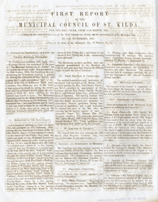
Document - Annual report, First Report by the Municipal Council of St Kilda, 1857
First report of the Municipal Council of St Kilda, for the half-year from 11 March 1857 - 11 September 1857. The Municipal District of St Kilda was proclaimed on 24 April 1855 but the election of the Council was delayed by a dispute over boundaries. This report outlines the process of deciding on the boundaries and establishing the Council, which met for the first time on 11 March 1957.Four-page report, printed double sided on two sheets of folded blue bank papermunicipality of st kilda, st kilda - history, 19th century -
 Eltham District Historical Society Inc
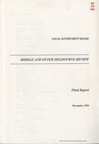
Book, Local Government Board, Middle and Outer Melbourne Review: Final Report, November 1994
Final report folllowing a review on the most appropriate local government structure for the middle and outer Melbourne metropolitan area covered by various municipal districts including Diamond Valley, Eltham, Heidelberg and Whittlesea in Melbourne's north. Contents include Structural issues, Boundary issues (for each location), Financial issues, The Proposals for each municipality and Final recommendations, produced by the Local Government Board113 pagesnon-fictionFinal report folllowing a review on the most appropriate local government structure for the middle and outer Melbourne metropolitan area covered by various municipal districts including Diamond Valley, Eltham, Heidelberg and Whittlesea in Melbourne's north. Contents include Structural issues, Boundary issues (for each location), Financial issues, The Proposals for each municipality and Final recommendations, produced by the Local Government Board council amalgamation, annexation, local government -
 Melbourne Tram Museum
Document - Report, Melbourne & Metropolitan Tramways Board (MMTB), "Municipal Miles, late 1920's to mid 1930's
File- card, green grey - Rondo of London type, titled "Municipal Miles" - giving the calculations and background paperwork for the breakdown of the tramway system by municipality. Used late 1920's to mid 1930's. The top sheet, scanned, though superseded shows the route miles by double track, single track, shared at council boundaries and the total miles of track. See Reg Item 2083 for tram miles for the system as a whole - was this information required for rate valuation returns.trams, tramways, mmtb, trackwork, mileages, reports, councils -
 Whitehorse Historical Society Inc.
Map - Parish Map, Parish of Nunawading, 1892
A map copied from 'Directory maps - parishes and counties' dated 26 Nov 1892. Compiled and lithographed by G.S. Bonney. The map includes roads, railway, stations, names of property owners. It has a scale [ca. 1:31,680] 40 chains to an 1 inch.A map copied from 'Directory maps - parishes and counties' dated 26 Nov 1892. Compiled and lithographed by G.S. Bonney. The map includes roads, railway, stations, names of property owners. It has a scale [ca. 1:31,680] 40 chains to an 1 inch.non-fictionA map copied from 'Directory maps - parishes and counties' dated 26 Nov 1892. Compiled and lithographed by G.S. Bonney. The map includes roads, railway, stations, names of property owners. It has a scale [ca. 1:31,680] 40 chains to an 1 inch.maps, parish of nunawading