Showing 119 items matching "north road brighton"
-
 City of Moorabbin Historical Society (Operating the Box Cottage Museum)
Photograph - Photograph , City of Moorabbin Mayoral Chain, circa 1990
City of Moorabbin was proclaimed 1934 and managed the areas of Cheltenham, Highett, Moorabbin, Bentleigh, East Bentleigh, East Brighton, McKinnon, Ormond until the Amalgamation of Councils in 1994. The City of Kingston then took over the area south of South Road while City of Glen Eira took the area to the north Kingston City Council possesses the original Mayoral Chain of former City of Moorabbin and it is displayed on the Moorabbin Mayoral Robe at KCC Office Cheltenham for the Annual Opening meeting of KCC in February . 2018 The Moorabbin Mayoral Robe was sent on 7 year loan to KCC for display at Cheltenham with the former City of Chelsea and former City of Mordialloc Mayoral Robes.Since the 1960s far-sighted community members have generously donated many significant items to the ‘Box Cottage’ museum, specifically to provide future generations with a fascinating, and tangible insight into day-to-day life from the 1800’s and up to the mid 1900's. Moorabbin City Council supported their efforts until the Amalgamation of Councils 1994. The City of Kingston donated the 1990 City of Moorabbin Mayoral Robes in 2007 Photograph of the City of Moorabbin Mayoral Chain circa 1990 in a glass covered, wooden frame Photograph of Mayoral Chain worn by Kingston City Council Mayor Steve Staikos, with Councillor Brownlees, in November 2018 when Robe and Jabot were loaned to KCC by CMHS Box Cottage MuseumPlate at base of photograph frame states ' City of Moorabbin Mayoral Chain /Manufactured By / P. Blashki & Sons Pty.Ltd'/moorabbin, kingston, mayors, glen eira, mayoral chain, moorabbin shire -
 City of Moorabbin Historical Society (Operating the Box Cottage Museum)
Photograph - Map of Dendy's Special Survey, 1852 Map of Henry Dendy's Special Survey of 1841, 19th Century
A Map drawn in 1852 that shows the 5,120 acres that formed Dendy's Special Survey of 1841. In 1840 Henry Dendy, a farmer in Surrey, England acquired a "Special Survey" from the Commissioners for Land and Emigration which gave Dendy the right to choose land in Port Phillip for the "bargain basement" price of only £1 per acre for 5120 acres, (an area of 8 square miles). The Special Survey also included the right to "the shipment of a worker for every £20 spent on land, whose free passage was paid by the Crown, equalling a total of 100 workers ". Accordingly Dendy sold his English holdings and paid the required £5120 and arrived in Melbourne in February 1841. However by this time land in the new colony was selling for £5 - £40 per acre. Because Henry Dendy possessed the order from the Colonial Office in London he was able to successfully oppose Governor LaTrobe's attempts to alter the price of the land. Dendy appointed Jonathan Were, (an entrepreneur, who had arrived in 1839), as his Manager and who later became a partner. Together, Dendy and Were decided on an area 5 miles south from Melbourne, bounded by North Road, East Boundary Road, South Road and to the west by Port Phillip Bay. Were and Dendy pitched their tents in the area now known as ' Park St, Brighton' and sank a well near the corner of 'St Andrew's St and Wells St'. By 1845 J.B Were and Company had bought almost half of Dendy's land and Were built himself "Moorabbin House" in Were St Brighton made from stone, quarried from local cliffs. It was still standing in 1924. Legend records Moorabbin is named after the Aboriginal word for ' Mother's Milk ' The soil is very fertile and well supplied with water especially in the area called 'East Brighton' - now known as Bentleigh and East Bentleigh - By 1850 the area had developed with numerous market gardens, dairy farms, fruit gardens and vineyards supplying food for the growing population of Melbourne.This Map shows the birth of the Brighton and Moorabbin area. On 18th January1859 Brighton was proclaimed a Municipality and a Borough by October 1863. Meanwhile, following a Petition, the area of East and South Brighton, incorporating Mordialloc, Cheltenham, Mentone, Sandringham and Oakleigh separated from Brighton to form the Moorabbin District Roads Board becoming the first Local Government Authority. Col. William Mair was elected as the first Chairman of the Moorabbin Roads Board. Moorabbin Shire 1871 developed further and was declared a City in1934. The City of Moorabbin was the largest Municipality in Melbourne before the Amalgamation of Councils in 1994 when it was divided in the south to City of Kingston and in the north to City of Glen Eira A Photo-lithographed 1852 Map showing the 5,120 acres that formed Dendy's Special Survey of 1841. Henry Dendy & Jonathan Were chose an area 5 miles south from Melbourne, bounded by North Road, East Boundary Road, South Road and to the west by Port Phillip Bay. Moorabbin County of Bourke / Photo-Lithographed at the department of Lands and Survey. /Melbourne. / Price 1/- brighton, moorabbin, bentleigh, cheltenham, dendy henry, bent thomas, were jonathan, special survey -
 City of Moorabbin Historical Society (Operating the Box Cottage Museum)
Book, Stirling, Amie Livingstone, Amie, Memories of an Australian Childhood, 1980
Amie Livingston Stirling 1880-1945 recorded her memories of growing up in Omeo, Elwood and San Remo in Victoria and in 1880s and '90s. About her father James Stirling, the famous coal-mining pioneer and geologist. Her grand-daughter Linda Harrison compiled her writings and added stories from her later life in Paris and North Africa274 p. : ill., ports., tables ; Pale blue hardback book of the childhood memories of Amie Livingston Stirling1880- 1945, compiled by her grand-daughter Linda Harrison in1980 non-fictionAmie Livingston Stirling 1880-1945 recorded her memories of growing up in Omeo, Elwood and San Remo in Victoria and in 1880s and '90s. About her father James Stirling, the famous coal-mining pioneer and geologist. Her grand-daughter Linda Harrison compiled her writings and added stories from her later life in Paris and North Africastirling james, reid elizabeth, early settlers, pioneers, surveyors, geologists, gippsland, omeo, elwood, melbourne, victoria, geelong, mining, botany, von mueller baron, elster creek, brighton, moorabbin, howitt alfred william, murray r a f, goodsir agnes, amie stirling -
 St Kilda Historical Society
Photograph, CableTram, c. 1905
also stamped on back D.J. Taggartblack and white photograph1900. CableTram (North Carlton to St Kilda) in Lonsdale St, Melbourne about 1905. Brian Pump 36 Knaith road, Ringwood East. Phone: 8707001. Rathdowne, Lygon and Swanston sts and St Kilda rd. Rathdowne st to Brighton rd. 49 North Carlton and St Kilda. -
 Ballarat Tramway Museum
Ephemera - Timetable/s, Melbourne and Metropolitan Tramways Board (MMTB), Set of 24 MMTB Melbourne tram timetables, 1969
Set of 24 MMTB timetables for various routes, dated July 1969. Generally includes Sat and Suns, Good Friday and Christmas day as well as weekdays, unless noted otherwise. Also includes a map of the route, detailed time points, sections, connecting services, fares, and organisation address - 616 Little Collins St. Melbourne. Have been folded into ten portions. All on white paper unless noted otherwise. Items shown with an # - have a sticker modifying timetable information details on the front page. 1154.1 - Route 4 - Carnegie - City .2 - Route 4D - East Malvern (Darling Road) - City # .3 - Route 5 - Malvern Burk Road, - City # .4 - Route 6 - Glen Iris - City # .5 - Route 7 - Camberwell - City # .6 - Route 8 - Toorak - City # .7 - Routes 9, 10 and 12 - South Melbourne and St Kilda Beach - City (Brunswick St.) - via Collins St. .8 - Routes 10, 11 - West Preston and routes 9 & 9A Northcote .9 - Routes 15 & 22 - Moreland and 1 & 21 - East Coburg .10 - Route - 15 & 16 - St Kilda Beach and 1 & 2A - South Melbourne Beach - via Swanston St. .11 - Route 19 - North Coburg - City # .12 - Route 42 - Mont Albert - City # .13 - Routes 48 - North Balwyn and Burwood - City .14 - as above, but for Saturdays and Sundays on pink paper .15 - Routes 55 & 56, West Coburg - City - (William St.) - Domain Road. .16 - Route 57 - West Maribyrnong - City .17 - Route 59 - Essendon (Aerodrome) - City .18 - Route 64 & 65 - East Brighton - City .19 - Route 69 - Kew Cotham Road - St. Kilda Beach # .20 - Route 70 - Wattle Park - City # .21 - Routes 77 - Prahran - City, 78 - North Richmond - Prahran, 79 - North Richmond - St Kilda Beach .22 - Route 82 - Footscray to Moonee Ponds .23 - Route 88 - East Preston - City and Route 96, East Brunswick - City .24 - as above but for Saturdays and Sundays on pink paper. Images of a sample of documents added 16-11-2013.mmtb, timetables, melbourne -
 Bayside Gallery - Bayside City Council Art & Heritage Collection
Map, H.B. Foot, Plan of the Brighton Estate containing 5120 acres, first special survey at Port Phillip, c. 1842
This plan records the Brighton Estate, also known as Dendy's Special Survey. In 1840 Henry Dendy, a farmer in Surrey, England acquired a "Special Survey" from the Commissioners for Land and Emigration which gave him the right to choose land in Port Phillip for the low price of £1 per acre for 5120 acres. Dendy appointed Jonathan Binns Were, as his agent, who later became a partner. Together, Dendy and Were decided on an area 5 miles south from Melbourne, bounded by North Road, East Boundary Road, South Road and to the west by Port Phillip Bay. Their Brighton Estate was first surveyed by T. S. Townsend in May 1841 and was re-surveyed by Robert Hoddle. Dendy and Were were making plans to sell the land and advertised a 30-guinea prize for the best subdivision which was to be divided into a village, marine residences, suburban and cultivation allotments, with the remainder being divided into country sections. The competition was won by H.B. Foot, who planned the village around a reserve and crescents and a 'green belt' forming the town boundary. brighton estate, dendy's special survey, special survey, henry dendy, jonathan binns were, w.b. were, survey, plan, map, brighton, george ward cole, baker's lithographer, hibernian, subdivision, town planning, cartographic material, h.b. foot -
 Bayside Gallery - Bayside City Council Art & Heritage Collection
Photograph, Department of Crown Lands and Survey, Victoria, Melbourne Project: Brighton and Elwood, 1976
The Department of Crown Lands and Survey (1857-1983) was responsible for the administration of survey and mapping and the sale, occupation and management of crown land throughout its existence. This aerial photograph shows parts of Brighton and Elwood and was taken on 1 December 1976brighton, elwood, department of crown lands and survey, aerial photograph, elsternwick park, point ormond, north road, ormond esplanade, st kilda street, glen huntly road, bayside, port phillip bay, map, cartographic material, melbourne project 1976 -
 Bayside Gallery - Bayside City Council Art & Heritage Collection
Photograph, Department of Crown Lands and Survey, Victoria, Melbourne Project: Brighton, 1976
... Project 1976 Brighton Yacht Club Middle Brighton Baths North Road ...The Department of Crown Lands and Survey (1857-1983) was responsible for the administration of survey and mapping and the sale, occupation and management of crown land throughout its existence. This aerial photograph shows parts of Brighton and was taken on 1 December 1976brighton, department of crown lands and survey, aerial photograph, bayside, port phillip bay, map, cartographic material, melbourne project 1976, brighton yacht club, middle brighton baths, north road, st kilda street, new street -
 Bayside Gallery - Bayside City Council Art & Heritage Collection
Photograph, Department of Crown Lands and Survey, Victoria, Brighton, Elwood and Elsternwick, c. 1965-71
The Department of Crown Lands and Survey (1857-1983) was responsible for the administration of survey and mapping and the sale, occupation and management of crown land throughout its existence. This aerial photograph shows parts of Brighton, Elwood and Elsternwick and was taken circa 1965-71.brighton, department of crown lands and survey, aerial photograph, bayside, port phillip bay, map, cartographic material, elwood, elsternwick, elsternwick park, elwood tram depot, elwood pier, new street, glen huntly road, st kilda street, nepean highway -
 Bayside Gallery - Bayside City Council Art & Heritage Collection
Sculpture, Jeffery Wilkinson, The swimmer, c.1950s, cast 1999
Jeffery Wilkinson, The swimmer c.1950s, cast 1999, bronze, 162 x 250 x 46 cm. Bayside City Council Art and Heritage Collection. Commissioned 1999.bronze Public Art Commission located on Beach Rd, north of Hampton Life Saving Club, Hampton, Victoria.swimmer, female, sculpture, public art, bronze, hampton, beach road, jeffery wilkinson, coastal art trail -
 Bayside Gallery - Bayside City Council Art & Heritage Collection
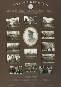
Photograph - gelatin silver photograph, Visit of His Royal Highness the Prince of Wales to the Municipality of Brighton, 1920
In 1920 the Prince of Wales embarked on a journey to Australia on behalf of his father, King George V. While the visit was intended to strengthen the relationship between Australia and the Empire, the main objective was to offer thanks to the Australian men and women for the sacrifices and contributions that they had made during World War I. The Royal Tour began in April 1920 and covered 110 cities and towns across the country. The Prince spent eleven days in New South Wales, nine days in Victoria, four days in Tasmania, eleven days in Western Australia, six days in South Australia and eight days in Queensland. On Saturday 5 June 1920, following a morning at the races in Flemington, the Prince spent the afternoon at ANZAC Hostel in Brighton, where he chatted to wounded soldiers and, according to the newspaper reports at the time, "won the hearts of all present."prince of wales, his royal highness, hrh, royal tour, anzac hostel, brighton, mayor, cr. thomas wilson, j.h. taylor, town clerk, soldiers, diggers, crowd, guard of honour, captain grieve, h.m.s. renown, north road, kamesborough, bayside -
 Bayside Gallery - Bayside City Council Art & Heritage Collection
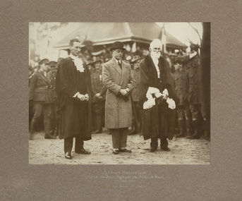
Photograph - gelatin silver photograph, Visit of His Royal Highness the Prince of Wales to Brighton, 1920
In 1920 the Prince of Wales embarked on a journey to Australia on behalf of his father, King George V. While the visit was intended to strengthen the relationship between Australia and the Empire, the main objective was to offer thanks to the Australian men and women for the sacrifices and contributions that they had made during World War I. The Royal Tour began in April 1920 and covered 110 cities and towns across the country. The Prince spent eleven days in New South Wales, nine days in Victoria, four days in Tasmania, eleven days in Western Australia, six days in South Australia and eight days in Queensland. On Saturday 5 June 1920, following a morning at the races in Flemington, the Prince spent the afternoon at ANZAC Hostel in Brighton, where he chatted to wounded soldiers and, according to the newspaper reports at the time, "won the hearts of all present."prince of wales, his royal highness, hrh, royal tour, anzac hostel, brighton, mayor, cr. thomas wilson, j.h. taylor, town clerk, soldiers, diggers, crowd, north road, kamesborough, bayside -
 Bayside Gallery - Bayside City Council Art & Heritage Collection
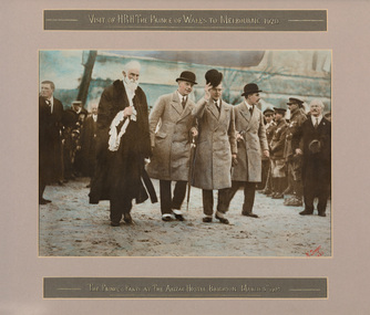
Photograph - hand tinted gelatin silver photograph, H. Singer, The Prince and party at The Anzac Hostel, Brighton, 1920
In 1920 the Prince of Wales embarked on a journey to Australia on behalf of his father, King George V. While the visit was intended to strengthen the relationship between Australia and the Empire, the main objective was to offer thanks to the Australian men and women for the sacrifices and contributions that they had made during World War I. The Royal Tour began in April 1920 and covered 110 cities and towns across the country. The Prince spent eleven days in New South Wales, nine days in Victoria, four days in Tasmania, eleven days in Western Australia, six days in South Australia and eight days in Queensland. On Saturday 5 June 1920, following a morning at the races in Flemington, the Prince spent the afternoon at ANZAC Hostel in Brighton, where he chatted to wounded soldiers and, according to the newspaper reports at the time, "won the hearts of all present."prince of wales, his royal highness, hrh, royal tour, anzac hostel, brighton, mayor, cr. thomas wilson, soldiers, diggers, crowd, north road, kamesborough, bayside -
 Ballarat Tramway Museum
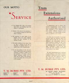
Pamphlet - Real Estate, T M Burke Pty Ltd, "Tram Extensions Authorised", 1936
Wal Jack collected tramway and railway items for his collection. This pamphlet gives details of the Melbourne Public Transport system - rail, tram and bus in late 1936. Issued by T M Burke Pty Ltd of 840 Collins St Melbourne, Real Estate agents, shows the extensive sub-divisions where land was available for purchase and notes the MMTB authorisation of new tram routes. Gives details of the T M Burke services. Routes shown as authorised (16-7-1936) are: Keilor Road Essendon, High St North Balwyn and Hawthorn Road East Brighton. Demonstrates a Real Estate Sales pamphlet.Pamphlet - four colours printed on cream coloured bond paper, folded vertically originally.letter, wal jack, buninyong, railway lines -
 Kew Historical Society Inc
Plan, Melbourne & Metropolitan Board of Works : Contour Plan of Melbourne & Suburbs : Melbourne Sewage, 1894
The Melbourne and Metropolitan Board of Works (MMBW) plans were produced from the 1890s to the 1950s. They were crucial to the design and development of Melbourne's sewerage and drainage system. This plan forms part of a large group of MMBW plans and maps that was donated to the Society by the Mr Poulter, City Engineer of the City of Kew in 1989. Within this collection, thirty-five hand-coloured plans, backed with linen, are of statewide significance as they include annotations that provide details of construction materials used in buildings in the first decade of the 20th century as well as additional information about land ownership and usage. The copies in the Public Record Office Victoria and the State Library of Victoria are monochrome versions which do not denote building materials so that the maps in this collection are invaluable and unique tools for researchers and heritage consultants. A number of the plans are not held in the collection of the State Library of Victoria so they have the additional attribute of rarity.Digital copy of an original MMBW plan. This contour plan shows the area identified by the MMBW for purposes of drainage and sewerage in 1894. The suburbs represented extend from Williamstown in the west to Bulleen in the east, and from Preston in the north, south to Sandringham. Suburbs are outlined in coloured ink. Red lines indicate main and branch sewers in existence at the beginning of 1894 in central and inner Melbourne. These extended as far as Williamstown and Brighton, but not yet as far as Kew, where sewering did not commence until 1901. Contour lines show the topography, which was important for indicating the fall of the land for the laying of sewers and drainage channels. Kew appears to be fairly undeveloped at this date except for railway lines and stations (the Kew and Outer Circle lines), main roads, the Kew Lunatic Asylum Reserve and Studley Park. However, the contour plan does not accurately represent the density of settlement, nor the large number of houses, which were being built in Kew and other suburbs from the 1850s to the land boom of the late 1880’s and early 1890’s. This plan is part of a large and historically significant group of MMBW plans and maps that was donated to the Society by the Mr Poulter, City Engineer of the City of Kew in 1989.mmbw contour plan of melbourne and suburbs, melbourne and metropolitan board of works, melbourne sewage, cartography -
 Kew Historical Society Inc
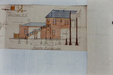
Slide - Architectural Drawing, Kew Public Offices, 1887
A civic campaign for new public offices developed in Kew in the 1880s. After much deliberation, the location chosen was the junction of Bulleen and Cotham Roads. The buildings were designed by George Watson and John Henry Harvey, architects within the Department of Public Works (Victoria). Building was commenced in 1887, and after one year, the buildings were opened. The Post Office was transferred to the new Commonwealth Government in 1901. The Police Station and Court House, sold by the Victorian Government to the City of Boroondara in 2007, are now a community cultural centre and performing arts venue.The buildings were listed on the Victorian Heritage Register Register (HO885) in 1991. They are historically and architecturally significant to the State Of Victoria because Watson and Harvey's designs exhibit diversity in integrating civil offices, they accommodate the apex of road junctions, and they demonstrate a departure from the contemporaneously favoured High Victorian Classical to the Queen Anne style in the design of civic buildings. 35mm colour transparency of an original plan by George Watson and John Henry Harvey, architects of the Department of Public Works (Victoria), in 1887 for New Public Offices at Kew. This plan was copied by the donor from an original held at the Commonwealth Archives in Brighton (Vic). The copy was made to illustrate a report that the donor made on ‘The functional planning design, building materials and construction methods of the Kew Post Office’ as part of course work at RMIT.NORTH ELEVATION / SECTION K-Kkew court house, kew police station, kew post office, architectural drawings, khs - slides, new public offices -- kew (vic.), architecture — queen anne style -
 Glen Eira City Council History and Heritage Collection
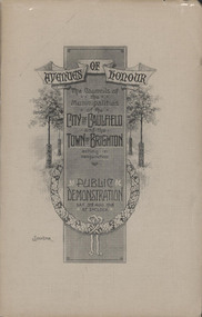
Booklet, "AVENUES OF HONOUR The Councils of the Municipalities of the CITY OF CAULFIELD TOWN OF BRIGHTON acting in conjunction PUBLIC DEMONSTRATION SAT 3rd AUG. 1918 AT 3oCLOCK"
Souvenir Programme from the Councils of the Municipalities of the City of Caulfield and the Town of Brighton for a Public Demonstration to be held on Sat 3rd August 1918 at 3 o'clock for the proposed Avenues of Honour to be planted in memory of fallen WWI soldiers. From Honour Roll Display 2019 interpretation panel - Brighton-Caulfield Avenue of Honour It is hard to imagine but a grand arboreal Avenue of Honour once lined parts of North Road, McMillan Street and Point Nepean Road (now Nepean Highway). The Avenue of Honour was a distinctly Australian phenomenon with hundreds being constructed throughout Australia during and following World War One, most of these in Victoria. Consisting of tree lined streets with each tree representing a solider, the Avenue of Honour signalled a more egalitarian approach to commemoration where rank was not a consideration. Arguably the most famous Avenue of Honour in Victoria still exists at Ballarat. Stretching for nearly 22 kilometres, the entrance to the Avenue is marked by the imposing Arch of Victory. Smaller in scale, the Brighton-Caulfield Avenue of Honour was dedicated to the ‘memory of (Brighton and Caulfield’s) kith and kin who came from (the) district and who died in the Great War’. A joint project between the neighbouring Councils, the idea was first reported in The Argus on 1 July 1918. Plans moved along quickly and on 3 August 1918 the Governor of Victoria Arthur Stanley planted the first Australian flowering gum. The next of kin were then invited to plant trees for lost sons, brothers, uncles, nephews and husbands. In all, over 400 trees were planted. Intensely personal, the Avenue also acted as a focus of grief and remembrance for the wider community. For many years, the annual civic Anzac Day service was held at the Avenue on Point Nepean Road, near Glen Huntly Road, Elsternwick. The service was moved to Caulfield Park upon the completion of the Cenotaph in 1930. Due to road widening and disease the last original tree was replaced in the 1980s, however a plaque in Caulfield Park records the Avenue’s plantation. Commemorative booklet, grey cover with text printed on the grey textured paper cover and an image of four trees and a wreath. Image of a kookaburra on the back. Inside, 28 numbered pages with b/w text and photographic images including a transparent paper representation of the proposed Avenues of Honour on Brighton Road and Point Nepean Road. Souvenir programme for a Public Demonstration for the Avenues of Honour as detailed on the front.city of caufield, world war one, first world war, anzac, remembrance, town of brighton, brighton, caulfield, avenue of honour -
 Glen Eira City Council History and Heritage Collection
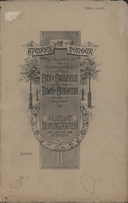
Booklet, D. W. Paterson Co. Pty. Ltd, "AVENUES OF HONOUR The Councils of the Municipalities of the CITY OF CAULFIELD TOWN OF BRIGHTON acting in conjunction PUBLIC DEMONSTRATION SAT 3rd AUG. 1918 AT 3oCLOCK SOUVENIR"
Souvenir Programme from the Councils of the Municipalities of the City of Caulfield and the Town of Brighton for a Public Demonstration to be held on Sat 3rd August 1918 at 3 o'clock for the proposed Avenues of Honour to be planted in memory of fallen WWI soldiers. One of two known copies, this copy has "Town Clerk" stamped in the upper corner, rhs.Commemorative booklet, grey cover with text printed on the grey textured paper and an image of four trees and a wreath. Image of a kookaburra on the back. Inside, 28 numbered pages with b/w text and photographic images including a transparent paper representation of the proposed Avenues of Honour on Brighton Road and Point Nepean Road. Souvenir programme for a Public Demonstration for the Avenues of Honour as detailed on the front. From Honour Roll Display 2019 interpretation panel - Brighton-Caulfield Avenue of Honour It is hard to imagine but a grand arboreal Avenue of Honour once lined parts of North Road, McMillan Street and Point Nepean Road (now Nepean Highway). The Avenue of Honour was a distinctly Australian phenomenon with hundreds being constructed throughout Australia during and following World War One, most of these in Victoria. Consisting of tree lined streets with each tree representing a solider, the Avenue of Honour signalled a more egalitarian approach to commemoration where rank was not a consideration. Arguably the most famous Avenue of Honour in Victoria still exists at Ballarat. Stretching for nearly 22 kilometres, the entrance to the Avenue is marked by the imposing Arch of Victory. Smaller in scale, the Brighton-Caulfield Avenue of Honour was dedicated to the ‘memory of (Brighton and Caulfield’s) kith and kin who came from (the) district and who died in the Great War’. A joint project between the neighbouring Councils, the idea was first reported in The Argus on 1 July 1918. Plans moved along quickly and on 3 August 1918 the Governor of Victoria Arthur Stanley planted the first Australian flowering gum. The next of kin were then invited to plant trees for lost sons, brothers, uncles, nephews and husbands. In all, over 400 trees were planted. Intensely personal, the Avenue also acted as a focus of grief and remembrance for the wider community. For many years, the annual civic Anzac Day service was held at the Avenue on Point Nepean Road, near Glen Huntly Road, Elsternwick. The service was moved to Caulfield Park upon the completion of the Cenotaph in 1930. Due to road widening and disease the last original tree was replaced in the 1980s, however a plaque in Caulfield Park records the Avenue’s plantation. Inkstamp upper corner rhs: "TOWN CLERK" -
 Surrey Hills Historical Society Collection
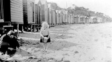
Photograph, Beatrice Mary Stalker, later Mrs Howard Breedon Everard, at the beach, 1930s
Mary Stalker’s engagement notice in The Argus in July 1947 indicates that she was the youngest daughter of Mr & Mrs A M Stalker of Montlare [Monclair] Avenue, North Brighton. It announces her engagement to ”Cr Howard Breedon Everard JP Ev-Ron, Woori Yallock, Youngest son of Hon WH Everard Wellington St Kew and the late Mrs Everard.” Beatrice Mary Stalker was born in 1919. Her parents were Alexander MacLaren Stalker (1885-1970/1973) and Charlotte Eleanor Hayward (1884-1953) who were married in 1911. Her sisters were Joan Winnock Stalker, Betty Neil Stalker and Ruth McLaren Stalker. Charlotte was a teacher prior to her marriage. Alexander, an accountant, lived in Wattle Valley Road, Canterbury in 1910. From 1912-1931 they are listed at ‘Benwerrin’, Wandsworth Road, Surrey Hills. Mary Stalker married in 1949 and by 1954 she and Howard were living at 44 Wandsworth Road, Surrey Hills, which was their home for decades. Howard was born in 1914 and died in October 2010: "EVERARD. - Howard Breedon. In loving memory of Howard, who lived life to the full to the very end of his 96 years. Greatly loved and honoured by Mary, Rosemary, David, Elizabeth, John and extended families." Beatrice Mary Everard died on 25 September 2019, aged 93. it is assumed that the woman in the photo is Mary's mother, Charlotte Eleanor Stalker (nee Hayward). The photo taken at the beach in 1930's may have been at Brighton, given the family’s later association with the suburb. This photo documents part of the social history of a family with a long and strong association with Surrey Hills. The backdrop of the typical bathing boxes used for changing into swimsuits, for lunch and for storing sports and beach gear, documents beach recreation and culture of the 1930s. Given the family's later residence in Brighton, this may well have been taken at Brighton Beach. For many years in the late nineteenth century, Brighton was Melbourne's favourite seaside destination. The now iconic bathing boxes were a response to Victorian ideas of morality and sea bathing. There are 82 Brighton bathing boxes, which protected by a heritage overlay because of their uniform scale and proportion, building materials, sentry order alignment. All retain their classic Victorian architectural features with timber framing, weatherboards and corrugated iron roofs. They remain as they did over one hundred years ago, as licensed bathing boxes. Service amenities such as electricity or water were never connected.A black and white photograph of a lady and little girl on the beach. There is a row of bathing boxes behind them.(miss) mary stalker, bathing boxes, (mrs) mary everard, (miss beatrice mary stalker, (mrs) beatrice mary everard, (mrs) charlotte eleanor stalker, (miss) charlotte eleanor hayward -
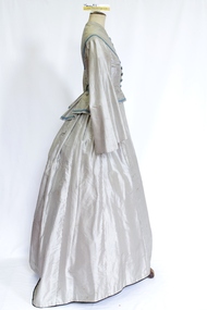 Brighton Historical Society
Clothing - Dress, Day dress, circa 1855-1872
This dress was donated as having belonged to Annie Elizabeth McLean, who worked as a maid to the daughters of Samuel Renwick of Caulfield. Annie was born in Argyllshire, Scotland in 1853. This dress appears to have been originally made circa 1855 and then modified circa 1872. As Annie would only have been two years old in 1855, this indicates that the dress would most probably have been originally made for someone else and later acquired by Annie. Annie Elizabeth McLean arrived in the Colony of Victoria from Argyllshire, Scotland with her aunts and cousins in 1867, aged thirteen and a half. She had been educated in Scotland and eventually became a personal maid and then companion to the Renwick girl, daughters of Samuel Renwick of Caulfield, Victoria. The Renwicks' home, 'The Garrell' on Glen Eira Road, was one of Caulfield's earliest residences, having been built around 1854. Samuel was a business partner of William Kerr Thomson, a well-known Brighton resident and the original occupant of the North Road mansion 'Kamesburgh'. During her time with the Renwick family, Annie travelled with them to England, then to Scotland, then back to Victoria. She left the family upon the marriage of the youngest Renwick daughter, then went to the household of Sir William and Lady McCullough until she left to be married to Alfred John Ashfold in 1878.This c1872 grey and white silk pin stripe dress features a high round neckline with eleven decorative blue silk buttons and secured by a concealed line of fifteen hook and eyelet closure. The bodice (.1) has decorative blue and green braid over the shoulder and bust and across the base of the bodice. The dress features three darts shaping the dress to the body. The sleeve is cut high but relatively full and tapers to the elbow then flares again in Pagoda like style but ends at the wrist or hand. The skirt (.2) opens over the left hip and features a pocket over the right hip. The skirt at the front finishes at the ankle or just above the ground. At the back the bodice features panels shaping the dress into the body and pleated and flared from the waist. At the small of the back is a decorative bow with pinked edges and decorative braid. The skirt at the back is uncommon in shape most likely as the result of modification. It appears to have had panels removed reducing its original fullness. It has a tape inside the back of the skirt that would draw the skirt in creating a bustle like shape . It would appear that the dress had been modified in order to create a more fashionable silhouette most probably in circa 1872. There are three separate pieces of fabric. One is made up into a semi-circular over-skirt trimmed with blue braid and fringing (.3). Two pieces are unpicked skirt gores, one still has its cotton lining attached (.4 and .5).annie elizabeth mclean, samuel renwick, the garrell, caulfield -
 Mont De Lancey
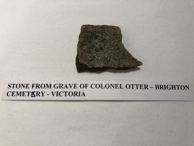
Stone
Stone from grave of Colonel Otter in Brighton Cemetery, Victoria.stones -
 Mont De Lancey
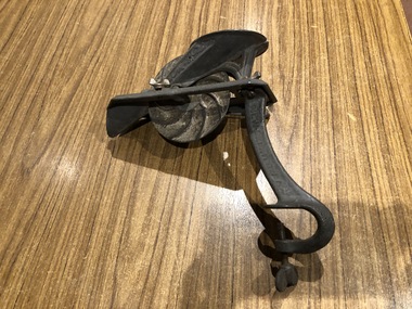
Cherry Stoner, Circa 1910
Hand-cranked cherry stoner."Logan & Strobridge" "New-Brighton. PA."food processing equipment -
 City of Moorabbin Historical Society (Operating the Box Cottage Museum)
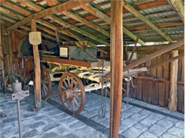
Functional object - Plateway horse-drawn wagon, c. 1883
This Plateway Wagon was built by Pengelly's Carriage Works, North Brighton 1883. The wagon was owned by the Corrigan family, market gardeners in Noble Park. It is an original, timber horse-drawn wagon that used the the Plateway or Wheelway from 1890. These heavily laden market gardener’s carts could travel relatively smoothly and safely, along the steel rails on the main roads of Moorabbin Parish to Melbourne and St Kilda markets to sell their produce, at a time when the road surfaces were rutted and hazardous.After the Henry Dendy Special Survey of the Parish of Moorabbin in 1841, land was sold to pioneer settlers who developed market gardens, vineyards and fruit gardens ( orchards ). These market gardeners took their produce in heavily laden horse-drawn Wagons along the steel Plateway to the markets in St Kilda and Melbourne. An original, timber horse-drawn wagon of a type that used the Plateway or Wheelway. The steel rails of the Plateway played such an important role from the 1890’s in the transportation of produce along the City of Moorabbin’s major roads, (including Centre Road, Bentleigh), to reach the markets in St Kilda and Melbourne. Heavily laden market gardener’s carts , drawn by a horse, could travel relatively smoothly and safely, along the steel rails to city markets, at a time when the road surfaces were rutted and hazardous. horse, melbourne, brighton, moorabbin, steel, henry, dendy, fruit, gardens, roads, plateway, wheelway, bentleigh, vineyards, orchards, draught, markets, st kilda, wagons -
 Melbourne Tram Museum
Album - Charles Craig - part 1 of 2, 1950s to 1970s
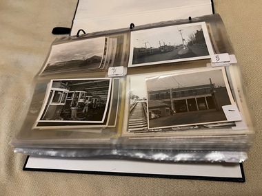
Photo - see pdf file for further information. Number Brief Description CC1 S178 at Elsternwick level crossing track works CC2 Building East Preston Depot 1955 CC3 Camberwell depot – post WW2 – lots of trams and a black cat CC4 W2 584 and SW6 958 northbound – Chapel St and Brighton Road CC5 W2 357 – southbound, Chapel St Brighton Road CC6 Pascoe Vale Road, Raceday working – note the signal CC7 The Preston Workshops - The Argus, post WW2, 223, 647 et al CC8 923 or is it 922 being built at Preston – The Argus photo - CC8A 832 being positioned onto trucks at Preston after an overhaul – Argus Photo – see also CC306 CC9 Footscray depot` CC10 W5 797 in St Kilda Road during track works – 1950s CC11 W2 457 at Kew Post Office CC12 Wellington Parade – W2 432, 492 and 337 – special event CC13 Swan St line up of trams – football? Or other special event – Sinclair’s bus on the right side. CC14 W2 630 being washed at a depot – The Argus photo CC15 Royal Park line at Flemington Road – W2 355 and W5 786 CC16 Nicholson St track construction from a tram cab CC17 T181 on tour at Gordon St CC18 T181 on Maribyrnong Bridge CC19 Ditto at River St just off bridge CC20 As for CC18 CC21 At Raleigh Rd CC22 T181 at Footscray depot CC23 Track construction, Nicholson, just north of Gertrude CC24 Commissioning overhead Bourke St tram 988 CC25 Queens Parade – 997 and 994 CC26 Swapping trolley wheel to skid – commissioning CC27 Track construction in Gertrude St CC28 985 in Queens Parade running special CC29 997 in Queens Parade CC30 1033 at North Fitzroy – AETA Special CC31 Bourke St at Elizabeth St – has passengers on board CC32 W6 985, 996 Queens Parade, Mk 3 bus 333 CC33 As above CC34 Showing construction at Nicholson & Gertrude – Bourke St CC35 W2 223 on Burnley temporary bridge – VR track expansion CC36 W5 823 – ditto CC37 Tram on old bridge prior to removal CC38 W2 433 on temporary bridge with new bridge beams and old track CC39 Looking down showing temporary single track – Swan St CC40 Tait train passing under tram bridge CC41 SW6 on single line – off loading CC42 W2 547 at City Road Junction CC43 City Road Jtn – 1969 – 596 and 771 CC44 City Road Jtn – 1969 – 596 and 771 (same as CC45 438 in Flinders St CC46 355 somewhere CC47 552 somewhere CC47A 364 at Preston Workshops? CC48 W2 334 on Traverser – Preston Workshops CC49 Wellington pade – large line up of trams, c1950 925, and 611 CC50 W2 493 Franklin st – advertising for Savings Certificates CC51 Possibly 551 with advertising for fund raising for Blind institute CC52 249 at Hawthorn – Riversdale Junction – with a Tally Ho and Village Fair Aux. board CC53 MMTB Postcard of 511 CC54 Wattle Park terminus with Single line warning sign CC55 Wattle Park Duplication CC56 36 at Domain Junction – 833 CC57 36 at Domain Junction CC58 36 at Domain Junction with 810 and 833 CC59 36 in Swanston by Flinders St Station CC60 36 in Spencer St at A’Beckett CC61 36 crossing Collins St CC62 36 crossing Collins St CC63 36 northbound in St Kilda Road with Shrine in background CC64 36 northbound in Swanston St at Flinders St CC65 Postcard – Ballarat 36 in Domain Road CC66 Postcard - Stampshow – Hawthorn Horse tram CC67 Postcard - Stampshow – Peace cable tram CC68 Postcard - 1041 and cable car set 1 at Preston CC69 Postcard - Colins & Elizabeth – greetings from old Melbourne CC70 Postcard - Cable car set at Preston CC71 Postcard - Twentyman’s cable cars CC72 Postcard - Nu-color-vue – horse tram 256 CC73 Cable car set – Market & Flinders CC74 Cable trams at Twentymans’ in their shed CC75 Cable tram track at Bourke & Spencer prior to removal CC76 Cable tram bogie at Preston Workshops – used as a dolly CC77 Cable trams at Twentymans’ CC78 Postcard - Valentines – Bourke looking west from Swanston CC79 Postcard - Rose 3938 – Bourke at Swanston – the Leviathan building CC80 Postcard - Valentines – Elizabeth St looking south from Collins – No. 19 CC81 Postcard - Rose P4765 – Bourke St Melbourne CC82 Postcard - Rose 4090 – cable tram passing Parliament house CC83 Postcard - Valentines – GPO Elizabeth St CC84 Interior of cable trailer with clothing on a set CC85 Elizabeth St looking north CC86 Cigarette card - Collins St No. 41- WD HO Wills CC87 Postcard - Rialto building with cable set CC88 Postcard - Valentines - Swanston at Flinders looking north CC89 CC90 Q 150 Hanna St – dated on rear CC91 176 turning – photo ex Alan Jungworth CC92 161 on Princes Bridge – minimum fare 4d sign and Inspector CC93 459 at Point Ormond CC94 158 at Gordon St – side on view CC95 X 217 in Swanston St CC96 X 217 in Swanston St with an East Brighton destination CC97 T177 CC98 T177 Peel St – no destination roll – being transferred? CC99 X1 462 in Glenhuntly Road to Point Ormond CC100 X1 462 in Glenhuntly Road to Elsternwick Rly Station CC101 X1 462 in Glenhuntly Road to Point Ormond CC102 Q 150 Hanna St CC103 190 at Camberwell Depot CC104 T182 at Footscray CC105 X1 466 and W2 at Footscray CC106 190 at Camberwell Depot CC107 X1 467 Barkly St Footscray CC108 X2 679 turning into William St from La Trobe St CC109 X2 677 Glenhuntly Road with Point Ormond Destination CC110 Postcard T180 CC111 Postcard format – X1 467 on a truck – see also CC178 CC112 Postcard format – X1 467 at Wantirna South CC113 Q200 and SW6 896 at Thornbury – has labels on rear CC114 T177, Ballarat Road – has labels on rear CC115 T178 at Point Ormond CC116 Postcard X1 465 and 466 CC117 Postcard – X2 676 CC118 Postcard – TMSV X2 217 CC119 810 on temporary bridging – 24-12-67 CC120 W2 575 – Queens Parade junction in, still temporary bridging, substation under construction CC121 Forming Queens Parade Junction base slab CC122 W2 596 prior to tramway works – all tracks still in position CC123 It’s a mass of reinforcing – bridging being formed CC124 Looking north with substation being built CC125 Looking east with some rather tight curves, Wellington St still in use CC126 SW6 958 ex Wellington St with all tracks and signal box and buildings. CC127 Victoria Pde at Gisborne looking east – at least 4 cars CC128 SW6 893? With dash canopy lights and SW6 862 and a man with a newspaper CC129 SW6 894 on the S curves, with tram in Wellington St CC130 Similar photo CC131 W2 564 turning into Wellington St – the concrete tracks are not that old CC132 W2 552 running out of Wellington St CC133 W5 732 from Fitzroy St into St Kilda Road with next iteration in position – very wonky CC134 W5 764 turning into Fitzroy St CC135 SW6 947 turning from Wellington St CC136 W2 586 running out of High St CC137 W2 500 turning into Wellington St CC138 W2 543 in Wellington St inbound CC139 L103 with St Kilda Junction destination, and a tower truck on right CC140 Workmen – new track in Queensway in use CC141 Ditto CC142 L103 in Queensway, and another car in bound CC143 Looking east along Wellington St which has been taken out of use. Also a MMTB Roller CC144 W5 824 and a W2 and all types of wobbly temporary track CC145 W2 354 to High St CC146 Sw6 947 on the S bends CC147 W2 500 looking north – tram on the S bends CC148 SW6 896 leaving the S bend CC149 W2 357 and a MMTB City bus with trees/gardens on the side CC150 W5 817 Elliot Ave – see also CC302 CC151 W2 552 – note the large trolley bridge CC152 W2 550 at depot or workshops CC153 1B truck CC154 SW2 432 CC155 W2 155 at Glenhuntly CC156 SW6 937 on AETA tour? CC157 X2 677 on Footscray service – Ballarat Rd? CC158 W2 641 – High St Kew? CC159 SW6 847 – Power St Hawthorn CC160 Simpson St – big line up CC161 W2 546 truck No. 1? CC162 W2s at Glenhuntly depot CC163 No. 15 truck under 899 CC164 206 and other junk at Preston Workshops CC165 W in Swanston St Melbourne – Rose series card CC166 Y1 613 Batman Ave?? or William St at Collins CC167 Tram plans CC168 X 217 Swanston St – see also 95 and 96 CC169 217 in Swanston St – same as 95 CC169A 192 in St Kilda Road at Princes bridge CC170 192 in St Kilda Road at Princes bridge CC171 Bendigo 3 arriving Malvern depot – being unloaded CC172 Ditto CC173 T180 at a depot CC174 X1 463 wheel set CC175 C30 – dog car side view – close up CC176 C30 dog car CC177 206 and 30 at Preston Workshops CC178 X1 467 on a truck – see CC111 also CC179 42 CC180 42 at a depot, no destination box CC181 W2 556 1A type truck CC182 Flinders St Station – Rose Series CC183 W7 1035 Spring – Nicholson St CC184 W7 1022 MMTB Post Card CC185 Adelaide 178 – has on rear – R. Lilburn 4/82 CC186 Adelaide 175 – has on rear – R. Lilburn 4/82 CC187 Y1 610 on AETA tour CC188 Y1 610 on AETA tour with large group – Point Ormond CC189 AETA display – has GH55-32 in pencil on rear CC190 AETA display – has GH55-29 in pencil on rear CC191 Y1 610 on AETA tour with large group – Point Ormond CC192 VR 53 at Footscray CC193 VR cars 40 and 34 at Elwood wash dock CC194 W7 1024 as the 1970 Christmas tram CC195 Geelong – loading a set of 22E trucks CC196 Geelong 10 and 23 running an AETA special CC197 Geelong – AETA special CC198 Geelong 7 at Junction CC199 Geelong 10, in the city CC200 Geelong 33 with Belmont destination CC201 Geelong 15 Eastern Park destination 29-3-1948 CC202 Geelong 23 at Railway Station – 29-3-1948 CC203 Geelong 23 at Railway Station – 29-3-1948 CC204 Geelong – loading a bogie tram CC205 Geelong – loading a bogie tram CC206 Geelong 40 – loaded on truck CC207 Geelong 40 – on jacks CC208 Geelong 40 on jacks – 19 behind CC209 Geelong 38 with two workers on either side CC210 – 214 Australian Historic Tramways stamp folder and set CC215 Bendigo 17 at depot – has dup JBS on rear CC216 Bendigo 20, 29 bogie and straight sill car at Charing Cross CC217 Bendigo one man bogie Pall Mall CC218 Bendigo – Bogie 23, other cars and welding truck at depot CC219 Bendigo 7 with Quarry Hill destination CC220 Bendigo 21 with Lake Weerona destination CC221 ESCo 18 Ballarat CC222 Ballarat bogie 22 on AETA special CC223 Ditto CC224 Ballarat 34 at Stones Corner – R Lilburn CC225 Ballarat 15 in Bridge St – R Lilburn CC226 Ballarat 40 at Gardens – R Lilburn CC227 Ballarat 37 running out of depot – R Lilburn CC228 Postcard – Valentines – Sturt St with loaded horse tram trailer CC229 AETA Geelong tram tour ticket – 29-3-1948 CC230 Postcard – Geelong – Valentine 2114 – T&G building CC231 Postcard – PMTT ! – High St Malvern CC232 Postcard – Empire – Glenferrie Road, Malvern at Wattletree Rd CC233 Postcard Y469, MMTB CC234 Postcard Z2 Spring St CC235 Postcard – Z1 MMTB CC236 Postcard – Stamp Show W1 431 CC237 Postcard – Stamp show B2005 CC238 Postcard – Stamp show W6 982 CC239 Postcard – Valentines 1264 – Johnstone Park with tram in distance CC240 Postcard – Rose 10711 – Swanston and Lonsdale – Hospital and W232 CC241 Postcard – Rose 4827 – Fitzroy St St Kilda W2 362 and 548 CC242 Postcard – Valentines – 939 – St Kilda War Memorial, W and a R? CC243 Postcard – Valentines – 572 – St Kilda War Memorial, W 413 and 140? CC244 Postcard – Valentines – 938 – Uper and Lower Esplanade – L 104 CC245 Postcard – St Kilda Rd at Princes Bridge Y1 and W CC246 Postcard – Biscay BG82 – W5 814 - CC247 Postcard – Biscay 796112 – Bourke St looking west CC248 Postcard – Biscay 796109 – Bourke St looking east CC249 Postcard – Biscay 2AUS58 – Z5 Bourke St CC250 Postcard – Biscay BG 249 – Swanston St CC251 Postcard – National View – St Kilda Rd – shrine and Prince Henrys W2 405 CC252 Postcard – Nu color vue – 11 ML 156 – St Kilda Rd CC253 Postcard – Nu color vue – 11 ML 153 – Swanston St CC254 Postcard – Nu Color vue – Collins St 442 CC255 Postcard – Pitt card – Adelaide – H 364 at Victoria St CC256 Postcard – SPER L/P 154 CC257 Postcard – BTMS – 550 CC258 Postcard – SPER – Brisbane 295 CC259 Adelaide 131 at Burnside – has R Lilburn on card, c1911 CC260 Adelaide 194 CC261 Adelaide 235, with two crew, The News photo CC262 Rockhampton, outside post office – has source of photo details CC263 Sydney – 2086 and 2062 arriving Circular Quay CC264 Sydney – P class – Pitt St? CC265 Sydney – 1610 at Circular Quay CC266 Brisbane 99 and 468 CC267 Sydney with bridge behind CC268 Steam tram Paramatta Park – 103 CC269 Sydney – Museum Station =- Elizabeth St CC270 Sydney – weed burner 137S at a loop Demonstrates the work of Charles Craig in photography and collection of prints.Assembled album in a black presentation folder of 270 photographs from the Charles Craig Collection - 86 sleeves - part 1 of 2. All photographs have been scanned and placed on the Museum's G drive. A list of all photographs with details where possible has been compiled. Victorian Provincial, Launceston, Hobart and Sydney tram photos have been transferred to other Museums, image files retained.melbourne, tramways, tramcars, trams, charles craig, st kilda junction, trackworks -
 Melbourne Tram Museum
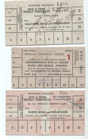
Ephemera - Rail & Tram weekly tickets, Victorian Railways (VR), c1935
Set of three Victorian Railways Rail & Tram weekly Periodicals with conditions of travel on the rear, See reference page 124 and Figure 6-27. Such tickets were introduced on 1/7/1939. All tickets were available for 14 tram trips only, but unlimited rail trips: 1 - Balcombe Road and Melbourne - First Class - white card - No. 1346, marked cancelled 13/5/1939 2 - Sandringham and cnr Bluff Road and Royal Ave - white card - Male, No. 41618, price 1/3 with a red 1 (first class?) - stamped cancelled 3 - North Road and Melbourne - white card overprinted in pink to leave a cross, Female, No. 506, Second class, with cancelled hand written on the front.Demonstrates a Victorian Railways Rail and Tram weekly tickets for both their tramways and the changes made over time. May have been used for training samples.Set of three printed card tickets with over printing and hand writing as shown.tickets, vr, vr trams, victorian railways, st kilda brighton tramway, weekly tickets, sandringham to black rock -
 Melbourne Tram Museum
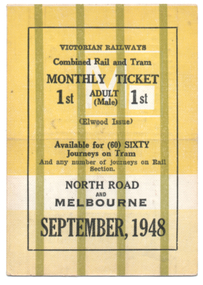
Ephemera - Rail & Tram Monthly ticket, Victorian Railways (VR), Sept. 1948
Victorian Railways Rail & Tram Monthly Periodical with conditions of travel on the inside. See reference page 124/125 and Figure 6-33. All tickets were available for 60 only tram trips, but allowed unlimited rail trips with 60 separate squares for a tram conductor to punch. This ticket is for First class travel, from North Road to Melbourne, though the rail portion only provided for first-class travel. Ticket No. 002 for September 1948. Colour of the ticket and markings varied for each month. Ticket has been cancelled with two red lines on one side.Demonstrates a Victorian Railways Rail and Tram monthly ticket for a specific section or trip on the St Kilda Brighton tramway. May have been used as a training sample.Printed card ticket, heavy card, coloured, with a crease in the middle so it could be folded.tickets, vr, vr trams, victorian railways, st kilda brighton tramway, monthy -
 Melbourne Tram Museum
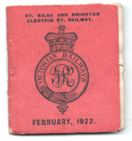
Ephemera - Tram Monthly ticket book, Victorian Railways (VR), Feb. 1922
Victorian Railways Rail & Tram Monthly Periodical book of tickets with conditions of travel on the inside covers. See reference page 124/125 and Figure 6-35. Book of 60 tickets (No. 49) for Feb. 1922 from North Road to St Kilda. The traveller also had to hold a monthly rail ticket for St Kilda station to Melbourne. The conductor would tear out each ticket and hand half one portion back to the traveller. Has been stamped "cancelled". See item 1688 for a single sheet example.Demonstrates a Victorian Railways Rail and Tram monthly ticket for a specific section or trip on the St Kilda Brighton tramway. May have been used as a training sample. Shows the complexity of the monthly ticket system and the cost of printing such books for each month and each section of the tramway.Printed book, 30 pages + red cover, centre stapled with perforated tickets or coupons.tickets, vr, vr trams, victorian railways, st kilda brighton tramway, monthy -
 Melbourne Tram Museum
Ephemera - Timetable, M>Tram, Set of 21 M>Tram timetables, Sep. 2002
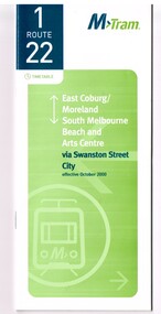
Set of 21 M>Tram timetables, light green cover with route number on cover, giving details of popular M>Tram destination, check points, map and description of routes, use of Metcards and contact details. .1 - Route 1 / 22 - East Coburg/Moreland to South Melbourne Beach - October 2000 - 36 pages. .2 - Route 3 - East Malvern - Melbourne University - January 2002 - 24 pages. .3 - Route 82 - Moonee Ponds - Footscray - October 2000 - 20 pages. .4 - Route 5 - Malvern (Burke Road) - Melbourne University - August 2003 - 32 pages. .5 - Route 6 - Glen Iris - Melbourne University - January 2002 - 24 pages. .6 - Route 8 - Toorak - Melbourne University - August 2003 - 24 pages. .7 - Route 16 - St Kilda Beach - Melbourne University - January 2002 - 24 pages. .8 - Route 19 - North Coburg - City - October 2000 - 36 Pages .9 - Route 55 - West Coburg - Domain Road Interchange - October 2000 - 28 pages. .10 - Route 57 - West Maribyrnong - City - October 2000 - 28 pages. .11 - Route 64 - East Brighton - Melbourne University - January 2002 - 32 pages. .12 - Route 67 - Carnegie - Melbourne University - January 2002 - 24 pages. .13 - Route 72 - Camberwell - Melbourne University - January 2002 - 24 pages. .14 - Route 78 / 79 - North Richmond - Prahran / St Kilda Beach - January 2003 - 20 pages. Full Image of .8 added 9/4/17 following a query about route 19 timetables - see image i2. .15 - Route 5 - Malvern (Burke Road) - Melbourne University - January 2002 - 32 pages .16 - Route 8 - Toorak - Melbourne University - January 2002 - 24 pages. .17 - Route 69 - Kew Cotham Road - St Kilda Beach - January 2002 - 20 pages .18 - Route 59 - Airport West - City - October 2000 - 32 Pages .19 - Route 78 / 79 - North Richmond - Prahran / St Kilda Beach - January 2002 - 20 pages. .20 - Route 82 - Moonee Ponds - Footscray - October 2000 - 20 pages. .21 - Route 67 - Carnegie - Melbourne University - Augst 2003 - 24 pagestrams, tramways, m>tram, tram services, timetables, route 1, route 22, route 82, route 5, route 6, route 8, route 16, route 19, route 55, route 57, route 64, route 67, route 72, route 78, route 79, route 69, route 59, route 82 -
 Melbourne Tram Museum
Ephemera - Timetable, The Met, Set of 12 Tram Timetables, produced by The Met, 1987 - 1989
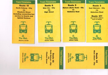
Set of 12 Tram Timetables, produced by The Met for various routes, yellow cover with a green top band, multi fold horizontal sheet, giving a route map, description, notes, time points, information contact details and types of tickets (Neighbourhood and Travelcards) and where they could be purchased. .1 - Route 3 - East Malvern - City via Balaclava Road - replaced by bus 377 on Sundays - dated 14/9/1987 .2 - Route 5 - Malvern Burke Road - City via Wattletree Road - 19/6/1988 .3 - Route 6 - Glen Iris - City via High St - 19/6/1988 .4 - Route 19 - North Coburg - City via Elizabeth St including connecting bus service to Gowrie and Upfield stations - 14/11/1988 .5 - Route 42 - Mont Albert - City - 15/8/1988 .6 - Route 48 - North Balwyn - City via Flinders St - 31/10/1988 .7 - Route 55 - West Coburg - Domain Interchange via William St - 11/2/1987 .8 - Route 57 - West Maribyrnong - City via North Melbourne - Route 357 bus replaces tram on Sunday - 27/8/1989 .9 - Route 59 - Airport West - City via Essendon - 27/8/1989 .10 - Route 64 - East Brighton - City via Hawthorn Road - 14/9/1987 .11- Route 70 - Wattle Park (Elgar Road) Princes Bridge via Swan St - 31/10/1988 .12 - Route 86 - Bundoora - City via West Preston - 15/8/1988 Full Image of .4 added 9/4/17 following a query about route 19 timetables - see image i5.trams, tramways, timetables, tickets, tram services, route 3, route 5, route 6, route 19, route 42, route 48, route 55, route 57, route 59, route 64, route 70, route 86 -
 Melbourne Tram Museum
Ephemera - Timetable, The Met, Set of 18 Tram Timetables, produced by The Met, 1986 - 1988
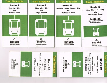
Set of 18 Tram Timetables, produced by The Met for various routes, white cover with two green, multi fold horizontal sheet, giving a route map, description, notes, time points, information contact details and types of tickets (Neighbourhood and Travelcards) and where they could be purchased. .1 - Route 3 - East Malvern - City via Balaclava Road - replaced by bus 377 on Sundays - dated 14/9/1987 .2 - Route 5 - Malvern Burke Road - City via Wattletree Road - 19/6/1988 .3 - Route 6 - Glen Iris - City via High St - 19/6/1988 .4 - Route 8 - Toorak - City via Toorak Road - 19/6/1988 .5 - Route 19 - North Coburg - City via Elizabeth St including connecting bus service to Gowrie and Upfield stations - 11/3/1987 .6 - Route 55 - West Coburg - Domain Interchange via William St - 11/2/1987 .7 - Route 57 - West Maribyrnong - City via North Melbourne - Route 357 bus replaces tram on Sunday - 1/12/1986 .8 - Route 59 - Airport West - City via Essendon -1/12/1986 .9 - Route 64 - East Brighton - City via Hawthorn Road - 14/9/1987 .10 - Route 67 - Carnegie - City via Glenhuntly Road - 14/9/1987 .11 - Route 69 - Kew (Cotham Road) - St Kilda Beach via Glenferrie Road - 19/6/1988 .12- Route 72 - Camberwell - City via Malvern Road - 19/6/1988 .13 - Route 75 - East Burwood - City via Flinders St - 15/2/1988 .14 - Route 78, Route 79, North Richmond - Prahran via Chapel St and North Richmond - St Kilda Beach via Chapel St - 13/7/1987 .15 - Route 82 - Footscray Moonee Ponds via Highpoint City and Route 223 bus replacement for Saturday afternoon and all day Sunday. 3/8/1987 .16 - Route 88 - Bundoora - City via Preston .17 - Route 96 - East Brunswick - St Kilda Beach via Bourke St City - 22/11/1987 .18 - Route 111 - Royal Exhibition Buildings - Port Melbourne via Bourke St City - 20/12/1987. (2nd copy added 1/4/20201( .19 - Route 600 - St Kilda - Middle Brighton via Elwood - 1/12/1986 Full Image of .5 added 9/4/17 following a query about route 19 timetables - see image i6.trams, tramways, timetables, tickets, tram services, route 3, route 5, route 6, route 19, route 55, route 57, route 59, route 64, route 8, route 67, route 69, route 72, route 75, route 78, route 78, route 79, route 82, route 88, route 86, route 111, route 600