Showing 16691 items matching "orbost-power-water-supply"
-
 Orbost & District Historical Society
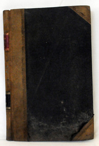
cash book, 1905 - 1914
This ledger was used by the Shire of Orbost pound keeper from 1906 - 1914. The item was donated to Orbost & District Historical society from P.R.O.V. as a Place of Deposit (POD) item for safe keeping by a local history group or museum. The shire covered an area of 9,347 square kilometres and existed from 1892 until 1994 when it became part of the East Gippsland Shire Council. Orbost was at first included in the Bairnsdale Shire from 1882 and was later part of the Tambo Shire. Because of travelling distances the Croajingalong Shire was created in 1892 (name changed to Orbost Shire 17.2.1893 with James Cameron as the first Shire President. In 1994 it amalgamated to become part of East Gippsland Shire Council. This book records the impounding of animals which have been found wandering on local roads or trespassing on land. Many are farm animals. Impounded animals were either claimed by their owners after payment of a fee or if unclaimed , they were sold. The Orbost Pound was situated on Martin Street.This book is a record of a practice which was necessary to remove stock which were wandering on local roads or trespassing on neighbours. It contains many local names and is of social interest. (ref. Vic. Collections)A ledger with a black cover, brown binding. The page edges are marbled. It contains hand-written records of payments received by the treasurer of the Orbost Pound.on spine : inside a red box in gold lettering"Pound Cash Book" inside a black box in gold lettering"Shire of Orbost"orbost-shire-council orbost-pound accounts cash-book -
 Melton City Libraries
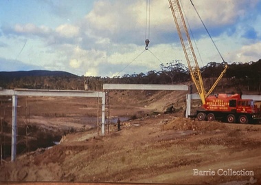
Photograph, Construction of Dam Wall- Melton Water Supply, 1963
Photographs of the construction of the dam wall for Melton's water supplylocal significant events, council, local architecture, local identities -
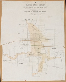
 Bacchus Marsh & District Historical Society
Map, Lerderderg District Proposed Irrigation and Water Supply Trust (A). Plan showing boundaries of Trust District
The 1886 Irrigation Act in Victoria introduced the first legislation in Australia designed to enable the creation of a detailed scheme for agricultural irrigation. Part of the legislation saw the use of government funds for local irrigation projects. These local projects were managed by local irrigation trusts. The Lerderderg Irrigation and Water Supply Trust] was formed in 1890. This map depicts the proposed area of the Trust.Printed paper map of the proposed Lerderderg District Irrigation and Water Supply. Plan showing boundaries of Trust District. The Lerderderg District lies within the Parishes of Korkuperrumul and Merrimu in the County of Bourke. At the top of the map above its title is the letter 'A; in capital lettering. Scale: 40 Chains = 1 inch.irrigation, water supply, lerderderg irrigation and water supply trust -
 University of Melbourne, Burnley Campus Archives
Plan, Water Supply, c. 1960
A. Plan of existing and proposed new buildings, temporary structures or due for demolition. Water Supply Plan sketched over. B. Sketch plan on tracing paper, further details of water supply.water suplly -
 Orbost & District Historical Society
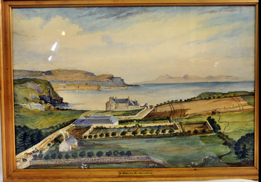
Painting, Blackney, I, Orbost - Isle of Sky - Scotland
This picture was donated by , Col & Mrs Swire after visiting Orbost Vic. They came from Orbost in the Isle Of Skye. The original watercolour was painted circa 1845 by Ann Lyon-Mackenzie.This painting has aesthetic significance and an association with the history of Orbost.A large watercolour reproduction picture of a property called Orbost on the Isle of Skye, Scotland. Gold frame with glass.Front - Orbost in the Isle of Sky, Scotlandwatercolour orbost isle-of-skyelyon-mackenzie-ann -
 Orbost & District Historical Society
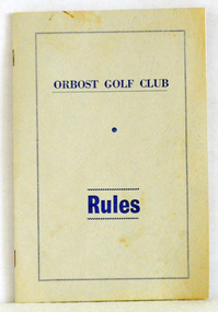
booklet, Snowy River Mail as "Mail" Print, Orbost Golf Club Rules, 1968
Published by the Orbost Golf Club.The golf club was established in 1906 it was originally formed as the Snowy River Golf Club and played on private land near the banks of the Snowy River just to the south of town. In the 1930’s the Golf Club relocated to its present site and was renamed Orbost Golf Club. The land was shared by the Show grounds and Racing Club. Orbost Golf Club later acquired the land outright to provide a permanent home for golfers in Orbost and surrounding district.A thin, 24pp booklet with a grey cover titled "Orbost Golf Club Rules". It contains the rules of the Orbost Golf Club and has a loose sheet with amendments. The cover has blue print.orbost-golf-club recreation sport golf -
 Bacchus Marsh & District Historical Society
Map, Bacchus Marsh District (A). Proposed Irrigation and Water Supply Trust. Plan shewing boundaries of Trust District
The 1886 Irrigation Act in Victoria introduced the first legislation in Australia designed to enable the creation of a detailed scheme for agricultural irrigation. Part of the legislation saw the use of government funds for local irrigation projects. These local projects were managed by local irrigation trusts. The Bacchus Marsh Irrigation and Water Supply Trust was formed in 1889. This map depicts the proposed area of the Trust.Printed paper map of the proposed Bacchus Marsh Irrigation and Water Supply district. Circa 1889. Plan showing boundaries of Trust District. The District lies within the Parishes of Korkuperrimul, Merrimu, Parwan and Gorrockburkchap in the Counties of Bourke and Grant. At the top of the map above its title is the letter 'A; in capital lettering. Scale: 40 Chains = 1 inch.irrigation, water supply, bacchus marsh irrigation and water supply trust -
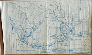 Orbost & District Historical Society
survey, 1941
this item is a useful reference tool.A survey map produced by the State Rivers and Water Supply Commission. It is on white paper with blue ink. It is a hand-drawn survey of the Snowy River in 1939-40.survey map snowy-river -
4th/19th Prince of Wales's Light Horse Regiment Unit History Room
Book, Operators Manual Radio Sets AN/VRC53 & AN/GRC1258 Amplifier Power Supply Group OA-3633/GRC
Handbook for equipment used by the RegimentSoft covered book detailing installation, operating instructions and operator's maintenance of Radio Sets AN/VRC53 & AN/GRC1258 Amplifier Power Supply Group OA-3633/GRCTM 11-5820-498-10handbook, radio, vrc -
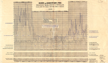 Whitehorse Historical Society Inc.
Document, Melbourne water supply, 1937
Melbourne and Metropolitan Board of Works. Melbourne water supply and sewerage. Diagrams showing water consumed, sewage pumped, rainfall and temperature, 1936.melbourne and metropolitan board of works, sewerage and sanitation, rainfall, temperature -
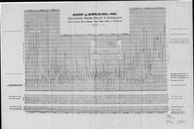 Whitehorse Historical Society Inc.
Document, Melbourne water supply, 1932
Melbourne and Metropolitan Board of Works, Melbourne water supply and sewerage diagrams showing water consumed, sewage pumped, rainfall and temperature, 1931.melbourne and metropolitan board of works, sewerage and sanitation, rainfall, temperature -
 Orbost & District Historical Society
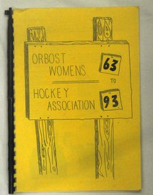
book, Orbost Women's Hockey 1963-1993
This is a local history book produced by a local sporting club.A spiral bound book of 18 pp with a yellow cover. It is titled Orbost Women's Hockey Association 63 to 93. There are hand drawings on the front cover.sport recreation hockey-women's-orbost -
 Bacchus Marsh & District Historical Society
Map, Lerderderg District Proposed Irrigation and Water Supply Trust (C). Plan showing overlap in boundaries of the Trust District
The 1886 Irrigation Act in Victoria introduced the first legislation in Australia designed to enable the creation of a detailed scheme for agricultural irrigation. Part of the legislation saw the use of government funds for local irrigation projects. These local projects were managed by local irrigation trusts. The Lerderderg Irrigation and Water Supply Trust was formed in 1890. Printed paper map of the proposed Lerderderg District Irrigation and Water Supply. Plan showing overlap in boundaries of Trust District referred to in Mr Burke's report. The Lerderderg District lies within the Parishes of Korkuperrumul and Merrimu in the County of Bourke. At the top of the map above its title is the letter 'C; in capital lettering. A note on this map states: 'Portion of Bacchus MarshUrban District included in area of proposed Trust District shown by hatched shaded lines thus /////////////irrigation, water supply, lerderderg irrigation and water supply trust -
Whitehorse Historical Society Inc.
Booklet - Pamphlet, A Historical survey of Melbourne's water supply, 1942
Based on an address by J.C. Jessop, 8 May 1942. With plan of Melbourne's water supply system.Based on an address by J.C. Jessop, 8 May 1942. With plan of Melbourne's water supply system.Based on an address by J.C. Jessop, 8 May 1942. With plan of Melbourne's water supply system.water supply, melbourne and metropolitan board of works., blackburn, james, hodgkinson, clement, oldham, t -
 Orbost & District Historical Society
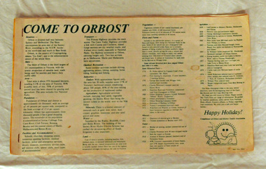
brochure, Come To Orbost, c 1980's
This brochure was produced as a tourist guide to Orbost.This item is a useful research tool.A magazine/brochure for use as tourist information. It contains the history, maps and touring routes of the Orbost district.tourism-orbost -
 Orbost & District Historical Society
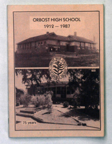
book, Snowy River Mail as "Mail" Print, ORBOST HIGH SCHOOL 1912 -1987, 1987
This magazine was produced for the 75th anniversary of Orbost High School. 2238.1 belonged to Mary Gilbert. 2238.2 belonged to Ruth Legge.Orbost High School / Orbost Secondary College has played a significant part in the education of senior students in the Orbost district . It is the sole senior educational institution. This item is representative of its history. It is a useful reference tool.Two copies of a 48 pp magazine titled, "Orbost High School 1912-1987". It has a pink cover with two photos of Orbost High School - 1925 and 1987. In the centre is the school badge.magazine-orbost-high-school -
 Orbost & District Historical Society
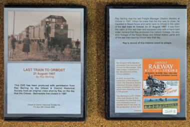
D.V.D. s, Last Train to Orbost, 21.8.1987
These are copies of an original video shot by Ray Barling on the day that the Orbost-Bairnsdale line closed in 1987. He used a hand-held video camera from his cabin on the train, The video was shown at the 2016 Centenary Exhibition in Orbost. The Bairnsdale-Orbost railway was opened in 1916 to serve the agricultural and timber industry. Because of the decline in traffic and heavy operating costs, the line was finally closed in August, 1987. Orbost Railway Station was opened on Monday 10 April 1916 as the terminus of the Orbost railway line, and closed in 1987. The station was located on the west side of the Snowy River despite the town of Orbost being on the east side of the river, in order to save on the costs of a bridge over the river, which at the time had highly variable levels. This item is associated with the history of the Orbost-Bairnsdale railway line and therefore reflects the role that the rail line played in the social and economic history of Orbost. On April 10 1916, the first scheduled train service left Orbost for Bairnsdale. The Bairnsdale-Orbost railway was opened to serve the agricultural and timber industry. Because of the decline in traffic and heavy operating costs, the line was finally closed in August, 1987. Orbost Railway Station was opened on Monday 10 April 1916 as the terminus of the Orbost railway line, and closed in 1987. The station was located on the west side of the Snowy River despite the town of Orbost being on the east side of the river, in order to save on the costs of a bridge over the river, which at the time had highly variable levels, The video was shown for the first time at the Centenary Exhibition held in Orbost, by the Orbost & District Historical Society, t created much interest leading to the production of the videos.Two copies of a D.V.D. titled"Last Train To Orbost 21 August 1987". The cover is a photo of the last train.rail-closure orbost-bairnsdale-railway -
 Bacchus Marsh & District Historical Society
Map, Lerderderg District Proposed Irrigation and Water Supply Trust (B) Plan Showing Proposed Works
The 1886 Irrigation Act in Victoria introduced the first legislation in Australia designed to enable the creation of a detailed scheme for agricultural irrigation. Part of the legislation saw the use of government funds for local irrigation projects. These local projects were managed by local irrigation trusts. The Lerderderg Irrigation and Water Supply Trust was formed in 1890. This map depicts the proposed area of the Trust and proposed works such as channels and weirs.Printed paper map of the proposed Lerderderg District Irrigation and Water Supply area showing proposed works. The map scale is 40 chains + 1 inch. The Lerderderg District lies within the Parishes of Korkuperrumul and Merrimu in the County of Bourke. At the top of the map above its title is the letter 'B; in capital lettering. A series of proposed channels are indicated on the map in red lines. A proposed weir site and alternative weir site are also indicated on the map. irrigation, water supply, lerderderg irrigation and water supply trust -
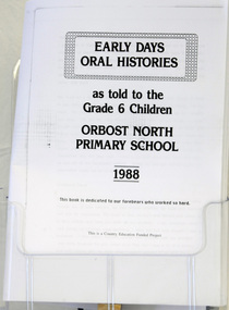 Orbost & District Historical Society
document, EARLY DAYS, ORAL HISTORIES as told to the Grade 6 children Orbost North Primary School 1988
The original document was published as a hard cover book and was funded by Country Education for Orbost North Primary School. It describes the social life and customs of the older people in Orbost.A black and white printed A3 photocopy of document produced by Grade 6 children of Orbost North Primary School. 44pages.orbost social-life orbost-north -
Alexandra Timber Tramway & Museum
Mr Sapsford, rubicon .Near power house (tin hut)
Power house was called the tin hut by those who built it and other locals . the building of Rubicon power house was helped by the timber indusary .As the timber and locals were helped by the building and supply of powerUn replaceablerubicon photo black and white of power house ,in forground chonnel running over the rubicon river , mens camp for workers in back ground . taken by Mr Sapsford of Alexandar . in good condrubicon . near power house (tin hut) -
 Stawell Historical Society Inc
Photograph, Stawell Water Supply Water Ranger’s Wife -- Mrs Cumming nee Unknown in a Jig in the Grampians
Stawell Water Supply Water Ranger’s Wife. Mrs. Cumming in jig Grampiansstawell -
 Buninyong & District Historical Society
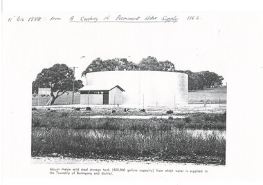
Photograph - Copy of a publication depicting Mount Helen water tank 1958, Mount Helen water tank 1958
This image depicts the opening of the permanent water supply for the Buninyong Township and District in 1958 for Buninyong Water TrustThis image illustrates the turning on the valve for the first permanent water supply to Buninyong in 1958A black and white photocopy of a photo showing the 500,000 gallon capacity water tank at Mount HelenMount Helen mild steel storage tank, (500,00 gallons capacity) from which water is supplied to the Township of Mount Buninyong and district.buninyong water trust, buninyong water supply, mount helen water storage tank -
Tatura Irrigation & Wartime Camps Museum
Map, State Rivers and Water Supply Commission, Goulburn Irrigation System, C 1940
A map showing the extent of Goulburn irrigation C. 1940. Also indicated by shading are: natural water resources, proposed extensions, existing stock and domestic supply areas, reservoirs, main channels, principal distribution channels, and railways.Irrigation Rivers Victoria.irrigation, victoria state rivers and water supply commission, map -
 Stawell Historical Society Inc
Photograph, Switching ON of the S.E.C. power supply for Stawell Sept 1968
Switching on of the S.E.C. power supply for Stawell. Sept 1968stawell electricity power -
Tatura Irrigation & Wartime Camps Museum
Document, Royal Commission on Water Supply - Minutes of Evidence, 1896
34 Pages of evidence taken at the 1896 Royal Commission on Water Supply. Some of the hearing was held at Tatura. A4 Photocopy -
 Federation University Historical Collection
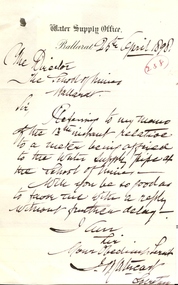
Document - correspondence, Ballarat Water Supply Office to Ballarat School of Mines, 25/08/1898
.1) A handwritten memorandum on 'Ballarat Water Supply Office' Memorandum letterhead. The Memo reads: Memorandum from the Water Supply Office, Grenville Street, near the Gas Works. Ballarat 13 April 1898 To the Registrar Schoolof Mines Ballarat Sir, I write your attention to the letter from this office dated 2nd December 1897 requesting that a suitable meter be affixed to the Water Supplu pipe at the School. I am directed to ask if the request has been complied with. Yours obediently J. [?]. Cathcart .2) A handwritten letter from J. Cathcart on 'Water Supply Office' letter head. The letter reads: Water Supply Office Ballarat 25th April 1898 The Director The School of Mines Ballarat Sir, Referring to my memo of the 13th instant relative to a meter being installed to the water supply pipe at the School of Mines - Will yo be so good as to favor me with a reply without further delay. I am Sir Your Obedient Serv't J. [M?] Cathcart Secretary.2) Written in a red circle '238'.ballarat school of mines, ballarat water supply, water, cathcart -
 Melbourne Tram Museum
Pamphlet, Yarra Trams, "Power supply upgrade project - J. S. Grey Reserve West Preston", Jul. 2016
Digital image of a folded A4 pamphlet titled "Power supply upgrade project - J. S. Grey Reserve West Preston", about the construction of a new sub-station on the reserve, gives construction dates, impact, site plan, elevation plan, reason or need for the sub-station for tram power upgrades. Dated July 2016. A4 print made for files.trams, tramways, substation, power supply, yarra trams, west preston -
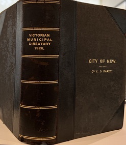 Kew Historical Society Inc
Journal, Arnall & Jackson: Printers & Stationers, Victorian Municipal Directory and Gazetteer : Also Commonwealth Guide and the Water Supply Record for 1928
The Victorian Municipal Directory provided annual details, and later bi-annual details, of all councils. Published by Arnall & Jackson (Printers and Stationers), copies were published in 'cloth' for sixteen shillings and 'half roan' for eighteen shillings. This copy was owned by Cr C.S.Parry. Elected to the Kew City Council as a representative of North Ward, Cr Parry was elevated to the position of Mayor in 1931. It, together with five other editions, was presented to the Kew Historical Society in 1987 by his grandson.Bound copy of the Victorian Municipal Directory and Gazetteer: Also Commonwealth Guide and the Water Supply Record for 1928. The volume contains 846 pages and includes sections on: - Comparative table – Municipal Returns for Twenty-one Years. - Index to Townships, Parishes and Railway Stations. - Changes and appointments. - Commonwealth of Australia (Constitution, Parliament, Departments and Officers). - State of Victoria (Parliament, Departments and Officers / Boards, Institutions, Trusts and Loans). - Municipalities in Victoria (Cities and Towns, Boroughs, Shires). - Water Supply (State Rivers and Water Supply Commission).non-fictionThe Victorian Municipal Directory provided annual details, and later bi-annual details, of all councils. Published by Arnall & Jackson (Printers and Stationers), copies were published in 'cloth' for sixteen shillings and 'half roan' for eighteen shillings. This copy was owned by Cr C.S.Parry. Elected to the Kew City Council as a representative of North Ward, Cr Parry was elevated to the position of Mayor in 1931. It, together with five other editions, was presented to the Kew Historical Society in 1987 by his grandson. victoria -- registers -- periodicals., victoria -- directories., water-supply -- victoria -- directories., municipal government -- victoria -- periodicals., cities and towns -- victoria -- directories. -
 Orbost & District Historical Society
rate books, 1977 - 1984
These items were donated to Orbost & District Historical society from P.R.O.V. as a Place of Deposit (POD) item for safe keeping by a local history group or museum. The shire covered an area of 9,347 square kilometres and existed from 1892 until 1994 when it became part of the East Gippsland Shire Council. The East Gippsland Region Water Authority was constituted on January 1, 1995. The new Authority assumed responsibility for the services previously provided by the Mitchell Water Board, the Tambo Water Board, the Orbost Water Board and the Mallacoota Water Board. East Gippsland Water is the registered business name of the East Gippsland Region Water Authority. (info. from P.R.O.) These items are a historical record of Orbost Shire transactions with water management authorities which no longer exist.Seven rate books for the Shire of Orbost, Mallacoota and Cann River Water Trust. 2554.1 with records from 1977-1978 has a brown cardboard cover and string binding. 2554.2 has a brown cardboard cover with a hand-written title and green string binding. Records are from 1978 -1979. 2554.3 has a brown cardboard cover with a hand-written title and green string binding. Records are from 1919 - 1980. 2554.4 has a white cardboard cover and taped spine. In black print on the cover is 1980/1981. 2554.5 has a green cover with a metal fastening clip. Records are from 1980 -1981. 2554.6 has a white cover, taped binding and metal clips.Records are from 1982 -1983. 2554.7 has a white cover and metal rings. It is dated 1984.water-rates cann-valley-water-board -
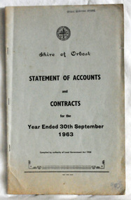 Orbost & District Historical Society
statement of accounts, Shire of Orbost Statement of Accounts, 1963
This document was made by the Shire of Orbost, local government. The Shire of Orbost was a local government area about 380 kilometres (236 mi) east of Melbourne, the state capital of Victoria, Australia. The shire covered an area of 9,347 square kilometres (3,608.9 sq mi), and existed from 1892 until 1994. Originally, Orbost was part of the Bairnsdale Road District which was created on 30 April 1867. Splitting away as part of the Shire of Tambo in 1882, Orbost was first incorporated as a shire in its own right as the Shire of Croajingolong on 30 May 1892. It received its present name on 17 February 1893. On 3 January 1913 part of its western riding was annexed to Tambo as its Cunninghame Riding. On 2 December 1994, the Shire was abolished, and merged with City and Shire of Bairnsdale, Shire of Tambo, most of Shire of Omeo and the Boole Boole Peninsula from Shire of Rosedale into the Shire of East Gippsland. Local governments play an important role in the lives of citizens in Australia. Local government authorities exist to provide services and amenities to local communities, and are also responsible for regulating and providing services for land and property in their district. This item is representative of a time when Orbost had its own Shire Council. A document with a light blue cover, black print. It is a "statement of accounts for the Shire of Orbost for the year ended 30th September, 1963".document-statement-of-accounts orbost-shire