Showing 150 items
matching plenty fire
-
 Greensborough Historical Society
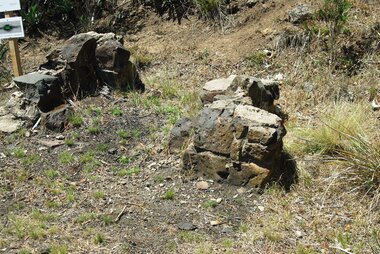
Photograph - Digital image, Marilyn Smith et al, Janefield Precinct: Old fire place on lower terrace, 27/11/2014
Janefield Precinct: Old fire place on lower terrace. The remains of this site are between Greensborough and Janefield. A RAAF Hygiene Training Camp was located on the Plenty River, just south of the Janefield community. It was in use from 1944 to 1946. The Camp was constructed from salvaged materials. Instruction included building and maintenance of grease traps, latrines, elementary plumbing and carpentry.Early remains of a WW2 training camp 2 Digital colour photographs. -
 Greensborough Historical Society
Photograph - Digital image, Outhouse, Willis Vale, 1920c
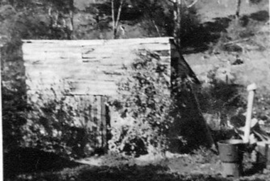
... in 1964 when a fire originating from North Plenty Gorge - Kurrak... was destroyed in 1964 when a fire originating from North Plenty Gorge ...This photograph shows one of the out buildings at 'Willis Vale', a property owned and farmed by the Partington family from the 1870s. The derelict Willis Vale house was destroyed in 1964 when a fire originating from North Plenty Gorge - Kurrak Road - was lit by two teenage boys and made its way several kilometres down to Partington's Flat Greensborough.The hoe of a pioneer Greensborough family.Digital copy of black and white photograph.willis vale, partington family -
 Greensborough Historical Society
Painting - Digital image, Barn at Willis Vale, 1920c
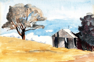
... Willis Vale house was destroyed in 1964 when a fire originating... a fire originating from North Plenty Gorge - Kurrak Road ...Painting of a barn at Willis Vale. 'Willis Vale' was owned and farmed by the Partington family from the 1870s. The derelict Willis Vale house was destroyed in 1964 when a fire originating from North Plenty Gorge - Kurrak Road - was lit by two teenage boys and made its way several kilometres down to Partington's Flat Greensborough. Gary Partington thought the barn was probably associated with the bull yard. (Note: Only some abandoned stumps existed when Gary was very young in the mid to late 1940s) Digital copy of painting.willis vale, partington family -
 Greensborough Historical Society
Photograph - Digital Image, Willis Vale, 1950c
... when a fire originating from North Plenty Gorge - Kurrak Road... Plenty Lower Plenty melbourne House built by Edward Maygar ...House built by Edward Maygar, Robert Whatmough lived there mid 19th century and later sold to Partington family. It was located on the Plenty River at Partington's Flat Greensborough. The derelict Willis Vale house was vandalized later destroyed in 1964 when a fire originating from North Plenty Gorge - Kurrak Road - was lit by two teenage boys and made its way several kilometres down to Partington's Flat Greensborough. This photo was taken after the Partington's moved house in 1947 across the river where Alan built their new Alwyn house that had access to electricity.A pioneer home in Greensborough.Digital copy of black and white photograph.willis vale, partington family, robert whatmough, maygar family -
 Greensborough Historical Society
Photograph - Digital image, Willis Vale, 1939c
... . It was located on the Plenty River at Partington's Flat Greensborough... was destroyed in 1964 when a fire originating from North Plenty Gorge ...Willis Vale: House built by Edward Maygar, Robert Whatmough lived there mid 19th century and later sold to Partington family. It was located on the Plenty River at Partington's Flat Greensborough. The derelict Willis Vale house was destroyed in 1964 when a fire originating from North Plenty Gorge - Kurrak Road - was lit by two teenage boys and made its way several kilometres down to Partington's Flat Greensborough.Home of the Partington family.Digital copy of black and white photograph.willis vale, partington family, maygar family, whatmough -
![Photograph - Digital image, Willis Vale [2], 1950c](/media/collectors/4f729f5697f83e03086015b8/items/54fd41442162f10d30bf885f/item-media/54fd41912162f10d30bf8caa/item-fit-380x285.jpg) Greensborough Historical Society
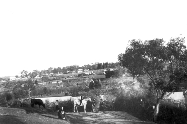
Greensborough Historical SocietyPhotograph - Digital image, Willis Vale [2], 1950c
... . It was located on the Plenty River across from Partington's Flat... when a fire originating from North Plenty Gorge - Kurrak Road ...View of Greensborough in the distance from Willis Vale and surrounding land: House built by Edward Maygar, The flowering Hawthorne Bushes were planted by William Partington. Note the prominent house on upper right where Robert Whatmough lived in the mid 19th century and later sold to Partington family. It was located on the Plenty River across from Partington's Flat. The derelict Willis Vale house was destroyed in 1964 when a fire originating from North Plenty Gorge - Kurrak Road - was lit by two teenage boys and made its way several kilometres down to Partington's Flat Greensborough. In 1946, Alan Partington built the Alwyn Farmhouse in place of the original Robert Whatmough home seen in this photo which became Whatmough Park circa 1976.Home of the Partington familyDigital copy of black and white photograph.willis vale, partington family, maygar family, whatmough -
![Photograph - Digital image, Willis Vale [house from distance], 1932c](/media/collectors/4f729f5697f83e03086015b8/items/54fd54082162f10d30c05b8a/item-media/54fd54392162f10d30c05f8f/item-fit-380x285.jpg) Greensborough Historical Society
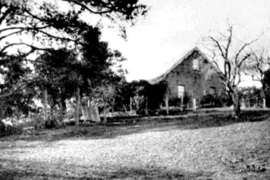
Greensborough Historical SocietyPhotograph - Digital image, Willis Vale [house from distance], 1932c
... . It was located on the Plenty River at Partington's Flat Greensborough... Plenty Lower Plenty melbourne Willis Vale: House built by Edward ...Willis Vale: House built by Edward Maygar, Robert Whatmough lived there mid 19th century and later sold to Partington family. It was located on the Plenty River at Partington's Flat Greensborough. Land use included farming and orchards. The derelict Willis Vale house was destroyed in 1964 when a fire originating from North Plenty Gorge - Kurrak Road - was lit by two teenage boys and made its way several kilometres down to Partington's Flat Greensborough.Home of the Partington familyDigital copy of black and white photograph.willis vale, partington family, whatmough, maygar -
![Photograph - Digital image, Willis Vale [3], 1878c](/media/collectors/4f729f5697f83e03086015b8/items/54fd5aeb2162f10d30c0aed5/item-media/54fd5b042162f10d30c0b12d/item-fit-380x285.jpg) Greensborough Historical Society
Greensborough Historical SocietyPhotograph - Digital image, Willis Vale [3], 1878c
... in 1964 when a fire originating from North Plenty Gorge - Kurrak... Plenty Lower Plenty melbourne Ellen and Charles Partington ...Ellen and Charles Partington at Willis Vale: House built by Edward Maygar, Robert Whatmough lived there mid 19th century and later sold to Partington family. It was located on the Plenty River at Partington's Flat Greensborough. Land use included farming and orchards. The derelict Willis Vale house was destroyed in 1964 when a fire originating from North Plenty Gorge - Kurrak Road - was lit by two teenage boys and made its way several kilometres down to Partington's Flat Greensborough.Home of the Partington familyDigital copy of black and white photograph.charles partington, willis vale, ellen partington -
 Greensborough Historical Society
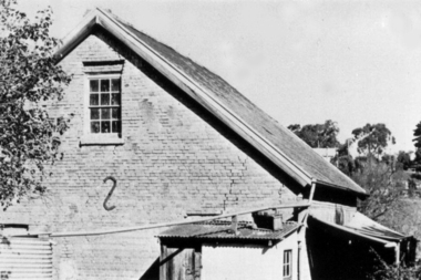
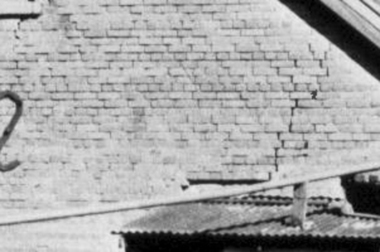
Photograph - Digital Image, Brickwork, Willis Vale, 1950c
... and later sold to Partington family. It was located on the Plenty... Plenty Lower Plenty melbourne Close up photograph of a section ...Close up photograph of a section of brickwork at Willis Vale. This is the end wall under the roof. Willis Vale built by Edward Maygar, Robert Whatmough lived there mid 19th century and later sold to Partington family. It was located on the Plenty River at Partington's Flat Greensborough. Land use included farming and orchards. The derelict Willis Vale house was vandalized in 1964 and destroyed when a fire originating from North Plenty Gorge - Kurrak Road - was lit by two teenage boys and made its way several kilometres down to Partington's Flat Greensborough. This photo was taken after the Partington's moved house in 1947 across the river where Alan built their new Alwyn house that had access to electricity.Part of Willis Vale, a pioneer home in the Greensborough area.Digital copy of black and white photograph.willis vale -
 Greensborough Historical Society
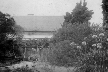
Photograph - Digital Image, View of Greensborough from Willis Vale, 1906_
... in 1964 when a fire originating from North Plenty Gorge - Kurrak... Plenty Lower Plenty melbourne View of Greensborough from Willis ...View of Greensborough from Willis Vale. The people in the photograph were visitors and not identified. Willis Vale: House built by Edward Maygar, Robert Whatmough lived there mid 19th century and later sold to Partington family. It was located on the Plenty River at Partington's Flat Greensborough. Land use included farming and orchards. The derelict Willis Vale house was destroyed in 1964 when a fire originating from North Plenty Gorge - Kurrak Road - was lit by two teenage boys and made its way several kilometres down to Partington's Flat Greensborough. [Ellen died on 13/10/1903 - Some think this photo is thought to have been taken shortly after, at her funeral.]Digital copy of black and white photograph.willis vale, greensborough, partington family -
 Greensborough Historical Society
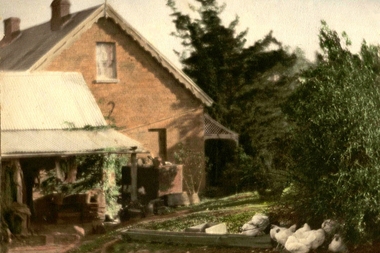
Photograph - Digital Image, Willis Vale, 1950c
... . It was located on the Plenty River at Partington's Flat Greensborough... when a fire originating from North Plenty Gorge - Kurrak Road ...Willis Vale: House built by Edward Maygar, Robert Whatmough lived there mid 19th century and later sold to Partington family. It was located on the Plenty River at Partington's Flat Greensborough. Land use included farming and orchards. The derelict Willis Vale house was vandalized in 1964 and destroyed when a fire originating from North Plenty Gorge - Kurrak Road - was lit by two teenage boys and made its way several kilometres down to Partington's Flat Greensborough. This photo was taken after the Partington's moved house in 1947 across the river where Alan built their new Alwyn house that had access to electricity.Home of the Partington familyDigital copy of black and white photograph.willis vale, partington family, whatmough, maygar family -
 Greensborough Historical Society
Photograph - Digital Image, Willis Vale, 1920c
... . It was located on the Plenty River at Partington's Flat Greensborough... Plenty Lower Plenty melbourne Willis Vale: House built by Edward ...Willis Vale: House built by Edward Maygar, Robert Whatmough lived there mid 19th century and later sold to Partington family. It was located on the Plenty River at Partington's Flat Greensborough. Land use included farming and orchards. The derelict Willis Vale house was destroyed in 1964 when a fire originating from North Plenty Gorge - Kurrak Road - was lit by two teenage boys and made its way several kilometres down to Partington's Flat Greensborough.Home of the Partington familyDigital copy of black and white photograph.willis vale, partington family, maygar, whatmough -
 Greensborough Historical Society
Photograph - Digital image, Willis Vale in Colour, 1940c
... . It was located on the Plenty River at Partington's Flat Greensborough... Plenty Lower Plenty melbourne Willis Vale: House built by Edward ...Willis Vale: House built by Edward Maygar, Robert Whatmough lived there mid 19th century and later sold to Partington family. It was located on the Plenty River at Partington's Flat Greensborough. Land use included farming and orchards. The derelict Willis Vale house was destroyed in 1964 when a fire originating from North Plenty Gorge - Kurrak Road - was lit by two teenage boys and made its way several kilometres down to Partington's Flat Greensborough.Home of the Partington familyDigital copy of colour photograph.willis vale, partington, whatmough, maygar -
![Photograph - Digital image, Willis Vale [front door], 1900c](/media/collectors/4f729f5697f83e03086015b8/items/55029fb42162f11024c2fdd5/item-media/55029fe62162f11024c300cd/item-fit-380x285.jpg) Greensborough Historical Society
Greensborough Historical SocietyPhotograph - Digital image, Willis Vale [front door], 1900c
... . It was located on the Plenty River at Partington's Flat Greensborough... Plenty Lower Plenty melbourne Willis Vale: House built by Edward ...Willis Vale: House built by Edward Maygar, Robert Whatmough lived there mid 19th century and later sold to Partington family. It was located on the Plenty River at Partington's Flat Greensborough. Land use included farming and orchards. The derelict Willis Vale house was destroyed in 1964 when a fire originating from North Plenty Gorge - Kurrak Road - was lit by two teenage boys and made its way several kilometres down to Partington's Flat Greensborough.Home of the Partington familyDigital copy of black and white photograph.willis vale, partington -
 Greensborough Historical Society
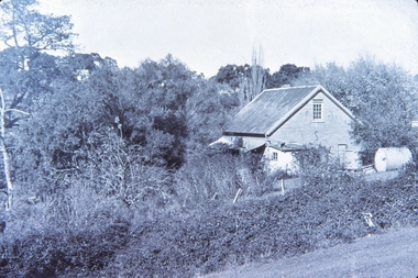
Photograph - Digital Image, Willis Vale, 1950c
... . It was located on the Plenty River at Partington's Flat Greensborough... when a fire originating from North Plenty Gorge - Kurrak Road ...Willis Vale: House built by Edward Maygar, Robert Whatmough lived there mid 19th century and later sold to Partington family. It was located on the Plenty River at Partington's Flat Greensborough. Land use included farming and orchards. The derelict Willis Vale house was vandalized in 1964 and destroyed when a fire originating from North Plenty Gorge - Kurrak Road - was lit by two teenage boys and made its way several kilometres down to Partington's Flat Greensborough. This photo was taken after the Partington's moved house in 1947; across the river where Alan built their new Alwyn house that had access to electricity.Home of the Partington familyDigital copy of black and white photograph.willis vale, partington, whatmough, maygar -
![Photograph - Digital image, Willis Vale [side view], 1950c](/media/collectors/4f729f5697f83e03086015b8/items/5502a2592162f11024c32328/item-media/5502a2852162f11024c3268d/item-fit-380x285.jpg) Greensborough Historical Society
Greensborough Historical SocietyPhotograph - Digital image, Willis Vale [side view], 1950c
... . It was located on the Plenty River at Partington's Flat Greensborough... when a fire originating from North Plenty Gorge - Kurrak Road ...Willis Vale: House built by Edward Maygar, Robert Whatmough lived there mid 19th century and later sold to Partington family. It was located on the Plenty River at Partington's Flat Greensborough. Land use included farming and orchards. The derelict Willis Vale house was vandalized in 1964 and destroyed when a fire originating from North Plenty Gorge - Kurrak Road - was lit by two teenage boys and made its way several kilometres down to Partington's Flat Greensborough. This photo was taken after the Partington's moved house in 1947. across the river where Alan built their new Alwyn house that had access to electricity. Home of the Partington family Home of the Partington familyDigital copy of black and white photograph.willis vale, partington, whatmough, maygar -
 Greensborough Historical Society
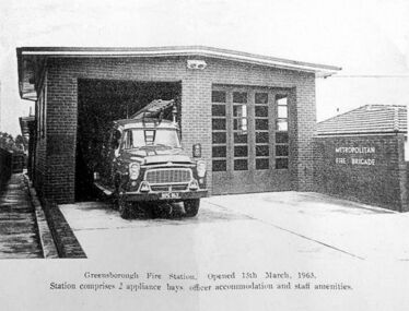
Photograph - Digital image, Church Street Fire Station, 15/05/1963
... Plenty Lower Plenty melbourne Opening of Fire Station in 1963 ...Opening of Fire Station in 1963. Greensborough had a fire service from 1938. It was relocated to Church Street in 1963 then moved to Grimshaw Street when Greensborough Plaza was developed.Digital copy of black and white photograph.greensborough fire station -
 Greensborough Historical Society
Photograph - Digital Image, Willis Vale, 1950c
... . It was located on the Plenty River at Partington's Flat Greensborough... was destroyed in 1964 when a fire originating from North Plenty Gorge ...House built by Edward Maygar, Robert Whatmough lived there mid 19th century and later sold to Partington family. It was located on the Plenty River at Partington's Flat Greensborough. The derelict Willis Vale house was destroyed in 1964 when a fire originating from North Plenty Gorge - Kurrak Road - was lit by two teenage boys and made its way several kilometres down to Partington's Flat Greensborough.Willis Vale was one of the earliest homes built in the area.Black and white digital photograph.willis vale, partington family -
 Greensborough Historical Society
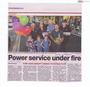
Newspaper Clipping, Power services under fire, 13/04/2016
Shop owners in Were Street Montmorency are concerned at the number of power outages that impact their businesses.News clipping, black text, colour image.were street montmorency, power outages, local businesses -
 Greensborough Historical Society
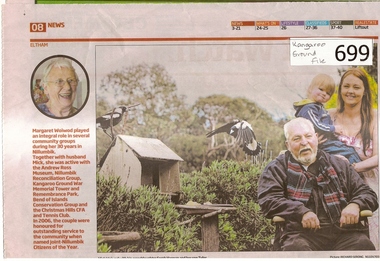
Newspaper clipping, Diamond Valley Leader, A Life Worth Celebrating, 12/09/2012
The item was written about Margaret Woiwod who passed away on August 1 2012.Margaret Woiwod was a prominent community minded person who lived in Bend of Isles for 25 years and later in Eltham North.A multi coloured 1 page newspaper article.Nilbend of isles, kangaroo ground fire tower, nillumbik reconciliation group, woiwod -
 Greensborough Historical Society
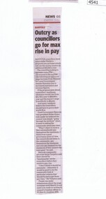
Newspaper Clipping, Diamond Valley Leader, Outcry as councillors go for max rise in pay, 22/02/2017
Banyule councillors have come under fire for a proposed pay increase which will see the mayor receive an additional $18,000 a year.News article 1 page, black text.banyule city council, pay increase, councillors -
 Greensborough Historical Society
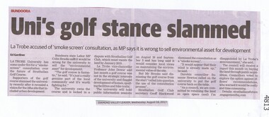
Newspaper Clipping, Diamond Valley Leader, Uni's golf stance slammed, 16/08/2017
La Trobe University has come under fire for a "smoke-screen" consultation over the future of Strathallan Golf CourseNews article 1 page, black text.la trobe university, strathallan golf course, darebin council -
 Greensborough Historical Society
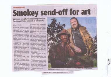
Newspaper Clipping, Diamond Valley Leader, Smokey send-off for art, 13/09/2017
Popular wooden sculptures inspired by wartime characters were set on fire and farewelled in a special ceremony over the weekend. The sculptures, created by chainsaw artist Leigh Conkie had stood at War Memorial Park for over a decade. They will be replaced by the Homefront Project.News article 1 page, black text, colour image.greensborough war memorial park, wooden sculptures, banyule city council, leigh conkie, homefront project -
 Greensborough Historical Society
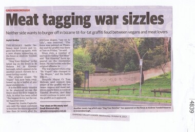
Newspaper Clipping, Diamond Valley Leader, Meat tagging war sizzles, 04/10/2017
The hungry battle between meat lovers and vegans has fired up again, with a new slogan appearing on the fence at Andrew Yandell Reserve.News article 1 page, black text, colour image.andrew yandell reserve, greensborough, graffiti, banyule council, yandell reserve -
 Greensborough Historical Society
Photograph - Digital Image, St Helena car fire 1957, 28/02/1957
... Plenty Lower Plenty melbourne A car fire in St Helena, 28th ...A car fire in St Helena, 28th February 1957. Sadly a man died [George Lawrey] in this car fire.Digital copy of photographst helena, fire -
 Greensborough Historical Society
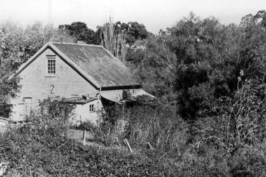
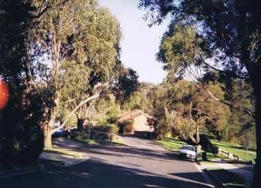
Photograph - Digital Image, Willis Vale site, 2014_
... in 1964 when a fire originating from North Plenty Gorge - Kurrak... Plenty Lower Plenty melbourne Photograph of the site ...Photograph of the site of the 'Willis Vale' homestead, home of the Partington family. The derelict Willis Vale house was destroyed in 1964 when a fire originating from North Plenty Gorge - Kurrak Road - was lit by two teenage boys and made its way several kilometres down to Partington's Flat Greensborough.Digital copy of colour photograph."This house is where Willis Vale homestead was on Partingtons Flat"partington family, willis vale -
 Greensborough Historical Society
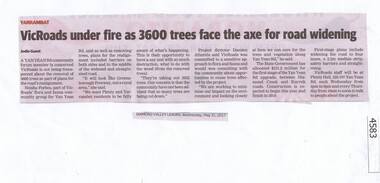
Newspaper Clipping, Diamond Valley Leader, VicRoads under fire as 3600 trees face the axe for road widening, 31/05/2017
A Yan Yean Rd community forum member is concerned VicRoads is not being transparent about the removal of 3600 trees as part of plans for the road’s realignment.News article 1 page, black text.yan yean road, vicroads, tree removal, yarrambat -
 Greensborough Historical Society
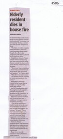
Newspaper Clipping, Diamond Valley Leader, Elderly resident dies in house fire, 14/06/2017
A Bundoora resident who woke to giant flames outside his home said “everyone was screaming” during a house fire that has left one person dead.News article 1 page, black text.bundoora, fire death -
 Greensborough Historical Society
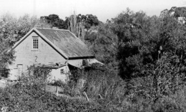
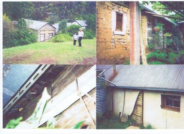
Photograph - Digital image, Happy Hollow, 1892o
Robert Emmett Whatmough leased the Happy Hollow site from John Cully McLaughlin in 1892 and built a bark house there. This was retained by later owners, the Bell family. Original photographs were taken prior to 2003, as the building was destroyed by fire in 2003Copies of four coloured photographs on one pagewhatmough family, happy hollow farm, bell family -
![Document, Graeme Butler & Associates et al, Bell's Cottage [Happy Hollow]: Victorian Heritage database report, 26/02/2017](/media/collectors/4f729f5697f83e03086015b8/items/59cc514221ea7a0f3c6ce8a6/item-media/59eeff6521ea67113c5b327b/item-fit-380x285.jpg) Greensborough Historical Society
Greensborough Historical SocietyDocument, Graeme Butler & Associates et al, Bell's Cottage [Happy Hollow]: Victorian Heritage database report, 26/02/2017
In 1997, Bell's Cottage at Happy Hollow Farm was included in the Nillumbik Heritage Overlay HO59.The cottage was built by Robert Whatmough and associated with the pioneering orchardists Frederick and Theodore Flintoff and William Verner. It is technically significant for its wattle and daub construction, vertical slabs and bark roof. It was destroyed by fire in 2003.3 p. typescript, one black & white photographhappy hollow farm, bell family