Showing 120 items
matching point nepean
-
 Chelsea & District Historical Society Inc
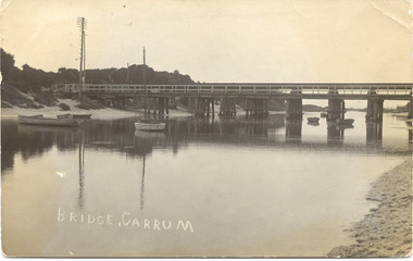
Photograph - Patterson River, Rail and Road Bridge
... Black and white photo of the road bridge (Point Nepean... (Point Nepean / Nepean Highway) and rail bridge, near the mouth ...The first bridge over the river was built in the early 1880's, prior to this it was a pontoon bridge.Black and white photo of the road bridge (Point Nepean / Nepean Highway) and rail bridge, near the mouth of the Patterson River. Taken from the mouth of the river.patterson river, road bridge, rail bridge, chelsea, transport, patterson river bridge, carrum bridge -
 City of Kingston
Pamphlet - Colour, Moorabbin News Print, Auction = Sale Heather Grove Estate, c. 1914
... , Railway Parade, Highett Road and Point Nepean Road.... Parade, Highett Road and Point Nepean Road. Auction = Sale ...Sales plan for land in the suburb of Cheltenham, bounded by Tulip Grove and Heather Grove.The developing urban area of Highett within the City of Kingston. This land sale pamphlet illustrates the subdivision of land within the municipality and the changing demographic of the district as new houses are constructed close to infrastructure.Colour pamphlet advertising auction of Heather Grove Estate, Cheltenham. Incorporates a map of the estate bordered by Wickham Road, Railway Parade, Highett Road and Point Nepean Road.Handwritten in grey pencil on subdivision 1: Sold / 20/- Handwritten in grey pencil on subdivision 2: 25/- Handwritten in grey pencil on subdivision 3: 30/- Handwritten in grey pencil on subdivision 4: 110 / 30/- Handwritten in grey pencil on subdivisions 1, 11, 10, 9 and 8: Sold Handwritten in grey pencil beneath 'Heather Grove': 20/- 20/- 20/- 20/- Handwritten in black ink on subdivison 12 and 7: £85 Handwritten in back ink on subdivision 5: £60 Handwritten in back ink on subdivision 6: £65 Handwritten in grey pencil above subdivision map: 1-8-9-10-11 Handwritten in grey pencil above subdivision map: [enclosed in a circle] 12- / £75 Handwritten in grey pencil above subdivision map: [enclosed in a circle] 2 / £85 Handwritten in grey pencil above subdivision map: [enclosed in a circle] 3 / £100 Handwritten in grey pencil above subdivision map: [enclosed in a circle] 4 / £100 Handwritten in grey pencil above subdivision map: [enclosed in a circle] 5 / £60 Handwritten in grey pencil above subdivision map: [enclosed in a circle] 6 / £65 Handwritten in grey pencil above subdivision map: [enclosed in a circle] 7 / £25- Handwritten in grey pencil above subdivision map: [enclosed in a circle] £125 / [indecipherable] Handwritten in grey pencil above subdivision map: 37.00 / 18.10 / 56.80 / 3 / [horizontal line] / 59 8 Handwritten in grey pencil along railway line marking: 21/6 / 12/6 / 13/- / 19/-land sales, estate, cheltenham -
 Queenscliffe Maritime Museum
Functional object - Porthole
... SS Cheviot was wrecked on Cheviot Beach, Sorrento, Point..., Sorrento, Point Nepean Salvaged from the wreck of the SS Cheviot ...SS Cheviot was wrecked on Cheviot Beach, Sorrento, Point Nepean Salvaged from the wreck of the SS Cheviot wrecked on 20 October 1887 with loss of life. Queenscliff Lifeboat unable to navigate the Rip due to treacherous weather2 Brass Portholes -
Whitehorse Historical Society Inc.
Document, Commonwealth of Australia, 1973
... and the area of the Point Nepean Defence Reserve for the purpose... defence road and the area of the Point Nepean Defence Reserve ...Officer Cadet School ordinary permit to use defence road and the area of the Point Nepean Defence Reserve for the purpose of sightseeing issued to Nunawading Historical Society for 16 Sep 1973.Officer Cadet School ordinary permit to use defence road and the area of the Point Nepean Defence Reserve for the purpose of sightseeing issued to Nunawading Historical Society for 16 Sep 1973.Officer Cadet School ordinary permit to use defence road and the area of the Point Nepean Defence Reserve for the purpose of sightseeing issued to Nunawading Historical Society for 16 Sep 1973.armed forces, officer cadet school, portsea, australian government -
 City of Kingston
Pamphlet - Colour, Highett Town, 1888
... by Wickham Road, Railway Parade, Highett Road and Point Nepean Road.... Parade, Highett Road and Point Nepean Road. Highett Town Pamphlet ...Sales plan for land in the suburb of Highett, bounded by Highett Road, Worthing Terrace and the railway line, and incorporating Major Street and Train Street.The developing urban area of Highett within the City of Kingston. This land sale pamphlet illustrates the subdivision of land within the municipality and the changing demographic of the district as new houses are constructed close to infrastructure.Colour pamphlet advertising for private sale the Station Entrance Estate, Highett. Incorporates a map of the estate bordered by Wickham Road, Railway Parade, Highett Road and Point Nepean Road.land sales, highett -
 City of Kingston
Pamphlet - Colour, H. R. Hill & Co, Walker's Estate, Cheltenham for sale by public auction, c. 1923
... bordered by Wickham Road, Railway Parade, Highett Road and Point... Parade, Highett Road and Point Nepean Road. Walker's Estate ...Sales plan for land in the suburb of Cheltenham, encompassing both sides of Walker Grove, a section of Centre Dandenong Rd and Axelton St. The developing urban area of Cheltenham within the City of Kingston. This land sale pamphlet illustrates the subdivision of land within the municipality and the changing demographic of the district as new houses are constructed.Black and white pamphlet advertising for private sale the Station Entrance Estate, Highett. Incorporates a map of the estate bordered by Wickham Road, Railway Parade, Highett Road and Point Nepean Road.Handwritten in black pen on subdivision map: 'x' written on subdivisions 2, 3, 8-11, 15-17, 19. Potentially indicating that these properties did not sell at auction. Handwritten in black pen on subdivision map: assumed sale price on subdivisions 1, 4-7, 12-14, 18, 20-31. land sales, cheltenham, estate -
 City of Kingston
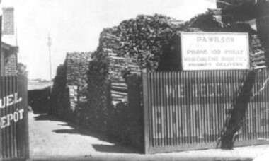
Photograph - Black and white, c. 1910
... Percy Wilson's woodyard was on Point Nepean Road... Parkdale Percy Wilson's woodyard was on Point Nepean Road ...Percy Wilson's woodyard was on Point Nepean Road, Cheltenham. Wilson was the local wood man and fuel merchant. Black and white image of a wood yard with a corrugated iron fence. Advertising is painted on to the fence, indicating they also sell briquettes. There is a sign on top of the fence including the business name, phone number and that it sells wood, coal, coke, and briquettes.cheltenham, wood, coal, briquettes, commerce, domestic -
 Uniting Church Archives - Synod of Victoria
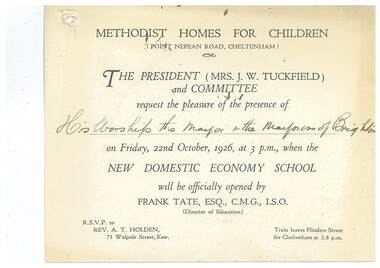
Document - Invitation, Methodist Homes for Children New Domestic Economy School
... at the Methodist Homes for Children, Point Nepean Road, Cheltenham... of the domestic economy school at the Methodist Homes for Children, Point ...E3000.30.1 White card printed invitation to the Mayor and Mayoress of Brighton to the opening of the domestic economy school at the Methodist Homes for Children, Point Nepean Road, Cheltenham. E3000.30.2 Copy of reply sent. Typed on pink paper.methodist homes for children, tuckfield j w mrs, tate frank -
 Chelsea & District Historical Society Inc
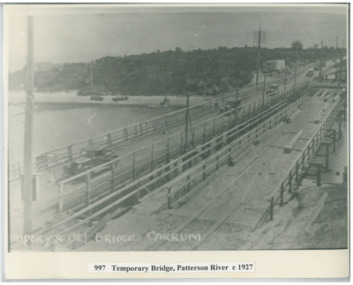
Photograph - Patterson River, Temporary and Old Bridge, c 1927
... Black and white photo of the old wooden road bridge (Point..., Carrum Black and white photo of the old wooden road bridge (Point ...The first bridge over the river was built in the early 1880's, prior to this it was a pontoon bridge. In 1927 the construction of a concrete bridge was undertaken.Black and white photo of the old wooden road bridge (Point Nepean / Nepean Highway), and a temporary bridge over Patterson River, Carrum near the mouth of the river. Cars using the old bridge. Rowing boats on shore. Temporary and old bridge, Carrumpatterson river, road bridge, rail bridge, chelsea, transport, patterson river bridge, carrum bridge, temporary bridge, cars -
 City of Kingston
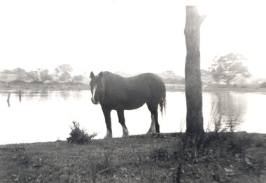
Photograph - Digital image, Black and white, c. 1950
... Street, looking towards Point Nepean Road.... Street, looking towards Point Nepean Road. This image shows ...Horse standing by a lake on the property of the Methodist Children's Homes, Cheltenham. The photograph is taken from Tennyson Street, looking towards Point Nepean Road.This image shows the land in Cheltenham, that later became Southland Shopping Centre. The land originally belonged to the Methodist Church, who operated a Children's Home on the property.Black and white image of a horse standing next to a tree trunk by a lake. cheltenham, methodist children's homes, southland, environment -
 Chelsea & District Historical Society Inc
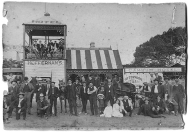
Photograph - Heffernan's Hotel, Carrum, c 1912
... situated in Point Nepean Road (now Nepean Highway). The hotel... situated in Point Nepean Road (now Nepean Highway). The hotel ...Thomas Heffernam (1860-1934) purchased the Carrum Hotel situated in Point Nepean Road (now Nepean Highway). The hotel was previously called Long Beach Hotel. The Riviera Hotel now occupies this site (2025).Black and white photo of a group of people standing in front of Carrum Hotel (Heffernan's), CarrumHeffernan's Carrum Hotel; Afternoon Teacarrum, seaford, carrum hotel, horse and cart, long beach hotel, riviera hotel, heffernan -
 Chelsea & District Historical Society Inc
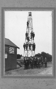
Photograph - Chelsea Fire Brigade Members, c 1920
... of the station which was situated on Point Nepean Road. Four members... of the station which was situated on Point Nepean Road. Four members Have ...Members of the Chelsea Fire Brigade, standing in front of the station which was situated on Point Nepean Road. Four members Have been identified: Standing on ground from the right, Captain J. J. Smith, Frank Jennings, Mr Frickie, Zeke Smith.Black and White phot of the members of the Chelsea Fire Brigade standing in front of the of the Fire station and on the bell and hose tower.firefighters, chelsea, chelsea fire brigade, fireman, fire equipment -
 Eltham District Historical Society Inc
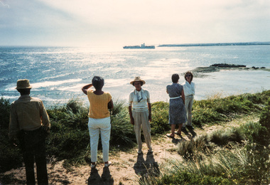
Photograph, Joh Ebeli, Ship passing the Rip, Portsea and Sorrento, 1 December 1985, 01/12/1985
... Reserve at Point Nepean. We also visited the Museum at Sorrento... Reserve at Point Nepean. We also visited the Museum at Sorrento ...[from EDHS Newsletter No. 46, January 1986:] Our bus trip to Portsea was considered by many to be one of the most enjoyable staged by the Society. Peter Collins of the Peninsula Historical Society travelled with us as a guide. He proved most informative and entertaining, particularly with regard to the Army and Quarantine Reserve at Point Nepean. We also visited the Museum at Sorrento and the site of the 1803 First Settlement. This was a long and tiring, but very rewarding, trip.Colour photographactivities, portsea, sorrento -
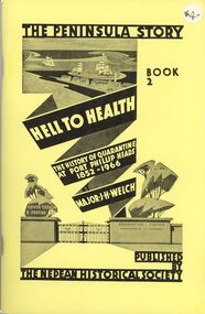 Bendigo Historical Society Inc.
Book - STRAUCH COLLECTION: THE PENINSULA STORY BOOK 2
... with scarlet fever and typhus. They were landed at Point Nepean... with scarlet fever and typhus. They were landed at Point Nepean ...Victoria's first quarantine station was established at Hobson's Bay in 1840. However with the influx of immigrants during the gold rush, a new station was needed in Port Phillip Bay. In 1852 the "Ticonderago" arrived with 300 passengers ill with scarlet fever and typhus. They were landed at Point Nepean, Portsea, which which was known as the "Sanitary Station" until the 1880's when it's name changed to the Quarantine Station. It ceased quarantine duties in 1980.The Peninsula Story Book 2 Hell to Health the history of quarantine at Port Phillip Heads 1852 - 1966 by Major J.H.Welch, published by the Nepean Historical Society. Soft cover 96 pages with black and white photographs.Major J H Welchvictoria, history, quarantine station, australia-quarantine station-portsea vic-history-victoria -
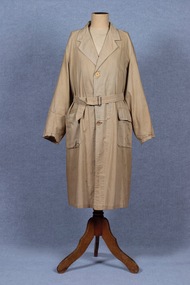 Brighton Historical Society
Coat, Dustcoat, c.1948
... managed a family grocery store circa 1948 at 510 Point Nepean Road... at 510 Point Nepean Road, East Brighton. Frederick was born ...Dust coat worn by Mr Frederick Alister Jennings when he managed a family grocery store circa 1948 at 510 Point Nepean Road, East Brighton. Frederick was born at Nagambie, Victoria in 1909 and died in Brighton in 1979. He was the son of Hugh Edwin Jennings and Alice Constance Warren. He married Margaret Jean Hughes in 1934 and served in the Second World War. He lived at 1 Valda Grove Brighton. Frederick was a commercial traveller as well as his time spent managing the store in Point Nepean Road. It is believed this coat dates from his time at the store c1948 - 1955. The store was owned for many years by his father-in-law W. G. Hughes and was one of a group of shops near the corner of Centre Road. In 1944-45 the group of shops included Fletcher’s fuel merchants, a haberdasher, butcher, fruiterer, grocer, Brighton East post office, a ladies’ hairdresser and Hughes’ grocer. In 1950 Hughes’ grocery store was between a service station and the Commercial Bank on what had been renamed Nepean Highway. The business was sold to G. S. Maynard, grocer, sometime before 1960.Unlined dustcoat of beige cotton. Fastens centre front with three brown plastic buttons. Two large patch pockets. Separate cloth belt with metal buckle. Signs of wear and mending. .1 - coat .2 -beltGarment label reads: APEX (RLG.) Dust Coat DEPT. MYER STORE for MEN. MELBOURNE & ADELAIDEdustcoat, occupational dress, grocer, hughes grocery store, brighton, frederick alister jennings -
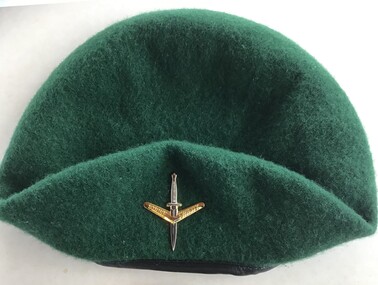 Queenscliffe Maritime Museum
Uniform - Beret
... to Point Nepean, simulating a raid. The weather was calm at Point... from Point Lonsdale to Point Nepean, simulating a raid ...On the evening of February 17, 1960, 74 peacetime commandos in army boats set off on a training exercise from Point Lonsdale to Point Nepean, simulating a raid. The weather was calm at Point Lonsdale on a midweek evening 50 years ago, but 50 years ago weather forecasts were not yet reliable. By nightfall a massive storm came through and all hell broke loose. Soon, three young Victorians were dead and more than 70 others were rescued from huge seas in Bass Strait.Green commando beret similar to ones worn by commandos involved in Rip Disaster of 1960Commando beret (green) with unit insigniaUnit insignia: "Strike Swiftly"commandos, beret -
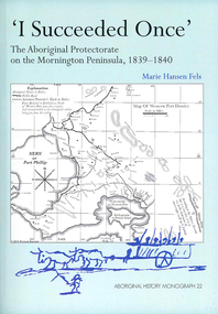 Victorian Aboriginal Corporation for Languages
Book, Marie Hansen Fels, I succeeded once : the Aboriginal Protectorate on the Mornington Peninsula, 1839-1840, 2011
... on the foreshore at McCrae 11. The abduction between Arthurs Seat and Point... on the foreshore at McCrae 11. The abduction between Arthurs Seat and Point ...1. The writings of William Thomas 2. The Context 3. The record of observation 4. Tubberubbabel, Protectorate head station 5. Kangerong, Protectorate second station 6. Buckkermitterwarrer, Protectorate third station 7. Kullurk, the Bonurong choice for a reserve 8. The raid into Gippsland and the massacres remembered 9. Manufacturing industry on the Mornington Peninsula, 'the successful plan at Arthurs Seat' 10. Death of Johnny and his burial on the foreshore at McCrae 11. The abduction between Arthurs Seat and Point Nepean, and Yankee Yankee's return 12. Thomas' translations.maps, document reproductions, b&w illustrations, colour illustrations, colour photographsboon wurrung, yarra mission, william thomas -
 Queenscliffe Maritime Museum
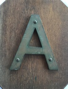
Sign - Metal letter A
... the notorious Corsair Rock, part of the Point Nepean Reef... the notorious Corsair Rock, part of the Point Nepean Reef ...The steamship, SS Australia, was built in Greenock, Scotland in 1892, for the P & O Steam Navigation Company. Australia was considered to be one of the most luxurious vessels afloat and she held the speed record from England to Australia at the time. On 21st June 1904, due to pilot error, the Australia hit the notorious Corsair Rock, part of the Point Nepean Reef, on the eastern side of Port Philip heads, opening a gaping 5 meter hole along her keel. Passengers and some of the crew were rescued by craft sent from Queenscliff.Relic from a significant wreck on Corsair Rock at Point NepeanMetal letter A mounted on timber board in front with salvage account on the backAccount of salvage of artefactsign, ships name, ss australia -
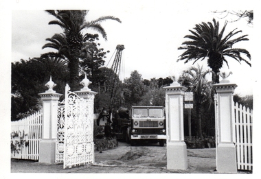 Williamstown Botanic Gardens- Hobsons Bay City Council
Photos - Cannons, 1970
... effectively replaced by new facilities at Queenscliff and Point Nepean... facilities at Queenscliff and Point Nepean, but they were still used ...The Armstrong Cannons were originally placed at Fort Gellibrand, located at the southernmost tip of the Williamstown peninsula. The Fort was developed during the 1850s as part of a defensive system for the city and port of Melbourne. The importance of the Fort batteries declined from the 1890s, when they were effectively replaced by new facilities at Queenscliff and Point Nepean, but they were still used for gunnery practice. Local residents, through the Williamstown Town Council, complained to the Acting Minister for Defence that the concussion from the guns damaged windows, walls and foundations of buildings. The Armstrong Cannons were moved from Fort Gellibrand to the Gardens in 1906. A primary source of evidence of the cannons being in the Gardens. The cannons are remembered fondly as play equipment for the local children. Many tales have been told of climbing over them and pretending to be shot out of them A collection of seven black and white photographs documenting the removal of the cannons from the Gardens Photo 1 (a) Black and white landscape image. View is looking through the main gates looking at the front of the truck, which has the name Walter Wright across the front bumper, the crane and canon. The gates and fence are painted a light colour, probably white. Photo 2 (b) Black and white landscape image. Back of loader with cannon on it. Man standing on top of the cannon bending over either tying or untying ropes. Trunk of a palm tree is on the left side of the photo with a top of a palm tree in the background. Photo 3 (c) Black and portrait white image. A cannon being loaded by the crane on to trailer. Palm tree is in the background and fronds from a palm tree can be seen in the right top corner. Photo 4 (d) Black and white landscape image. Side on view of a cannon on the truck parked outside the grounds of the Gardens. The logo of the name of the trucking company is on the door of the truck above the words ‘WALTER H WRIGHT / TRANSPORT PTY LTD / S SCHULZ ST WEST MELB’. A second cannon can be seen in the background. A bus is in the background on the middle right side of the image. Photo 5 (e) Black and white landscape image. Truck with cannon on the back leaving the ground of the Gardens. Tree on the right side of the image and power pole is behind the truck. The logo of the name of the trucking company is on the door of the truck above the words ‘WALTER H WRIGHT / TRANSPORT PTY LTD / S SCHULZ ST WEST MELB’. ‘WALTER WRIGHT’ is on the front bumper Photo 6 (f) Black and white landscape image. Cannon tied down on the back of the truck as it is being driven across the street. Three houses in the background and two cars, one is a Volkswagen Photo 7 (g) Black and white landscape image. Cannon on the back of the truck which is parked over the street from the Gardens. Three houses are in the background. Two trees bare of leaves. The front of a car in in the foreground – it has a sun visor and the steering wheel is a light colour.armstrong cannons, williamstown botanic gardens, hobsons bay city council, 1970, walter h wright / transport pty ltd -
 Glen Eira City Council History and Heritage Collection
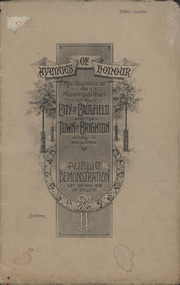
Booklet, D. W. Paterson Co. Pty. Ltd, "AVENUES OF HONOUR The Councils of the Municipalities of the CITY OF CAULFIELD TOWN OF BRIGHTON acting in conjunction PUBLIC DEMONSTRATION SAT 3rd AUG. 1918 AT 3oCLOCK SOUVENIR"
... on Brighton Road and Point Nepean Road. Souvenir programme... of the proposed Avenues of Honour on Brighton Road and Point Nepean Road ...Souvenir Programme from the Councils of the Municipalities of the City of Caulfield and the Town of Brighton for a Public Demonstration to be held on Sat 3rd August 1918 at 3 o'clock for the proposed Avenues of Honour to be planted in memory of fallen WWI soldiers. One of two known copies, this copy has "Town Clerk" stamped in the upper corner, rhs.Commemorative booklet, grey cover with text printed on the grey textured paper and an image of four trees and a wreath. Image of a kookaburra on the back. Inside, 28 numbered pages with b/w text and photographic images including a transparent paper representation of the proposed Avenues of Honour on Brighton Road and Point Nepean Road. Souvenir programme for a Public Demonstration for the Avenues of Honour as detailed on the front. From Honour Roll Display 2019 interpretation panel - Brighton-Caulfield Avenue of Honour It is hard to imagine but a grand arboreal Avenue of Honour once lined parts of North Road, McMillan Street and Point Nepean Road (now Nepean Highway). The Avenue of Honour was a distinctly Australian phenomenon with hundreds being constructed throughout Australia during and following World War One, most of these in Victoria. Consisting of tree lined streets with each tree representing a solider, the Avenue of Honour signalled a more egalitarian approach to commemoration where rank was not a consideration. Arguably the most famous Avenue of Honour in Victoria still exists at Ballarat. Stretching for nearly 22 kilometres, the entrance to the Avenue is marked by the imposing Arch of Victory. Smaller in scale, the Brighton-Caulfield Avenue of Honour was dedicated to the ‘memory of (Brighton and Caulfield’s) kith and kin who came from (the) district and who died in the Great War’. A joint project between the neighbouring Councils, the idea was first reported in The Argus on 1 July 1918. Plans moved along quickly and on 3 August 1918 the Governor of Victoria Arthur Stanley planted the first Australian flowering gum. The next of kin were then invited to plant trees for lost sons, brothers, uncles, nephews and husbands. In all, over 400 trees were planted. Intensely personal, the Avenue also acted as a focus of grief and remembrance for the wider community. For many years, the annual civic Anzac Day service was held at the Avenue on Point Nepean Road, near Glen Huntly Road, Elsternwick. The service was moved to Caulfield Park upon the completion of the Cenotaph in 1930. Due to road widening and disease the last original tree was replaced in the 1980s, however a plaque in Caulfield Park records the Avenue’s plantation. Inkstamp upper corner rhs: "TOWN CLERK" -
Queenscliffe Maritime Museum
Uniform - Uniform, commando
... Lonsdale to Point Nepean, simulating a raid. Swept out to sea... exercise from Point Lonsdale to Point Nepean, simulating a raid ...Equipment similar to that worn by commandos involved in Rip Disaster. On the evening of February 17, 1960, 74 peacetime commandos in army boats set off on a training exercise from Point Lonsdale to Point Nepean, simulating a raid. Swept out to sea through The Rip as they crossed the bay from Point Lonsdale, George ''Taffy'' Drakopoulos and Eddie Meyer drowned before they could be rescued. Another man, Roger Wood, selflessly helped his fellow commandos up a rope ladder to safety from a Zodiac inflatable, only to be flung off the end into an angry sea somewhere beyond The Rip. The three dead men were all from Melbourne, all aged around 20.Lifeboat Queenscliff assisted in the search for the lost commandos in February 1960Army commando webbing belt and pair of gaiterswebbing, uniform, commandos, rip disaster -
 Queenscliffe Maritime Museum
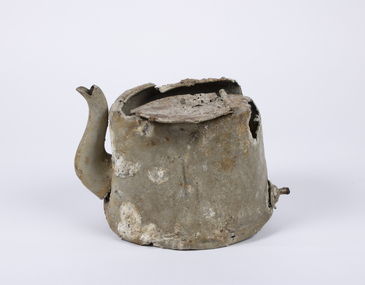
Domestic object - Teapot
... to Point Nepean to seek better anchorage due to impending bad... Queenscliff to Point Nepean to seek better anchorage due to impending ...In 1940, German minefields were laid in east and west Bass Strait which quickly claimed merchant ships Cambridge (British) and the City of Rayville (American). HMAS Goorangai had finished mine sweeping duties and after resupply was crossing from Queenscliff to Point Nepean to seek better anchorage due to impending bad weather. At around 20:30 on the 20th of November 1940 the 10,400-ton MV Duntroon was transiting the South Channel on her way to Sydney from Perth via Melbourne carrying 65 passengers and general and perishable cargo. It struck HMAS Goorangai forward of the funnel on the port side and cut her in two. At about 20:45 HMAS Goorangai sank in less than a minute resulting in the loss of her whole ship’s company, a complement of 24 officers and sailors.HMAS Goorangai was the first Royal Australian Navy (RAN) ship lost in WWII, the first RAN surface ship lost in wartime, and the first RAN surface ship lost with all hands. A memorial cairn was erected at Queenscliff in 1981 and a service of commemoration is held there every year.A severely damaged and corroded aluminium teapot recovered from the wreck of HMAS Goorangaihmas goorangai, wwii, collision at sea -
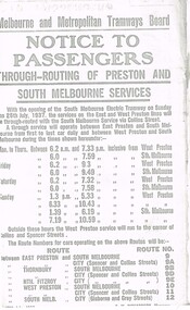 Melbourne Tram Museum
Document - Photocopy, Melbourne & Metropolitan Tramways Board (MMTB), "Notice to Passengers - Through routing of Preston and South Melbourne Services", Originals - 1937
... Cemetery tramway via Hawthorn Road, to Point Nepean Rd, East... - Extension of Brighton Cemetery tramway via Hawthorn Road, to Point ...Set of three photocopied notices onto foolscap, heat sensitive paper, c1937, with details of alterations due to revised or new tram routes. All signed S. M. Richardson as Manager. .1 - "Notice to Passengers - Through routing of Preston and South Melbourne Services" Gives new route numbers. Dated 10th July 1937. .2 - "Notice to Passengers - Extension of Brighton Cemetery tramway via Hawthorn Road, to Point Nepean Rd, East Brighton" - November 1937, part of copy missing on left hand side. Opening date to be 5th December 1937. .3 - "Notice to Passengers - Collingwood cable tramway bus service on Sunday mornings", gives details of bus times and frequency - and commencement times for the cable trams. Dated 3rd November 1937.trams, tramways, preston, south melbourne, east brighton, hawthorn rd, opening, routes, buses, cable trams, collingwood -
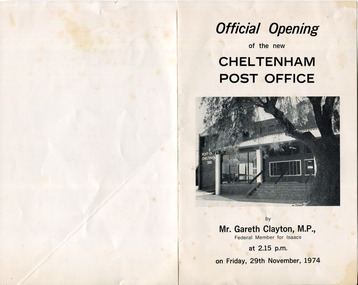 City of Moorabbin Historical Society (Operating the Box Cottage Museum)
Document - Program Official Opening Cheltenham Post Office, Government Printer, 1974
... building was built 1891 in Point Nepean Road for the official... building was built 1891 in Point Nepean Road for the official ...John Hitchen was the manager of the first Cheltenham Post Office that opened 1/8/1857 in a boot and shoe store. Mail was transported to and from St Kilda to Cheltenham by coach 6 days a week and an additional service twice weekly to Tootgarook via Frankston also by coach. 1868 Post office Savings Bank began operation and the Telegraph office was established at the Railway Station 1885. A new building was built 1891 in Point Nepean Road for the official Cheltenham Post Office and a new manual telephone exchange began 1899 with 24 subscribers. By 1909 100 subscribers, 1951 there were 1700 and in 1974 12,000 subscribers . Hence this new building was designed by Oscar A. T. Gimsey & Assoc. and built by T W Morris & Sons Mordialloc. Mr G Clayton Federal MP Isaacs, opened the Post Office with Moorabbin City Council Mayor C.R McHutchison, Mr WJB Pollock, Director Posts and Telegraphs, and hands the Key of the post Office to Mr L De Longville Postmaster.The Post Office was an integral part to the development and prosperity of the Cheltenham area as the area grew from pioneer settlers in the 1850's to flourishing market gardens c1900 and industrial diversity of 1974.Program for the 'Official Opening of the Cheltenham Post Office' November 29th 1974 with a black and white photo of the building.city of moorabbin, county of bourke, moorabbin roads board, parish of moorabbin, shire of moorabbin, henry dendy's special survey 1841, were j.b., bent thomas, o'shannassy john, king richard, charman s, highett william, ormond francis, maynard dennis, post office, telegraph, st kilda station, tootgarook, frankston, clayton g mhr, mchutchison r.p mayor, pollock w j b mp, market gardens, early settlers, horse coach, de longville l postmaster -
 City of Moorabbin Historical Society (Operating the Box Cottage Museum)
Photograph, Black & White Postcard, Cheltenham Railway Station c1920, c1920
... Point Nepean Rd to Charman Rd and by 1910 various shops... Line saw the traders move from Point Nepean Rd to Charman Rd ...Although the Railway line had been planned for some time Sir Thomas Bent MP was responsible for making it happen in order to revitalize the fortunes of the Moorabbin Shire that he had represented for so long. The train line opened in 1881with 8 Stations between Caulfield and Mordialloc.The first Steam engine carried dignitaries and local residents. Bent also ensured that the Station houses in his constituency were built in a distinctive decorative cottage style. Bent faced severe criticism for diverting the rail line through his local area and for the expenditure on the Stations. Local residents established and cared for Gardens at the Stations and Cheltenham was awarded Best Garden c1910. The arrival of the Railway Line saw the traders move from Point Nepean Rd to Charman Rd and by 1910 various shops and business were present. 2016 - current has seen large protest rallies against the destruction of Mentone Station and Cheltenham Station as the Victorian State Government proceeds to remove Railway Level Crossings. A compromise to retain the Station buildings whilst placing the Rail Line underground is desired.Cheltenham Railway Station is one of the original cottage style stations ordered by Sir Thomas Bent when the rail line was extended from Caulfield to Mordialloc 1881Photograph Black & White Postcard showing the entrance to Cheltenham Railway Station c1920Valentine &Sons Pub Co Ltd Melb railways, cheltenham station, mentone station, south brighton station, railway level crossing removal 2016 -19, smith j l; smith mary ann, stanley helen, smith vic, smith harry redvers, chaff cutter, horse drawn carts, toll gates brighton, motor cars 1900, steam engines, early settlers, bentleigh, parish of moorabbin, city of moorabbin, county of bourke, moorabbin roads board, shire of moorabbin, henry dendy's special survey 1841, were j.b.; bent thomas, o'shannassy john, king richard, charman s, highett william, ormond francis, maynard dennis, market gardeners, vineyards, orchards -
Queenscliffe Maritime Museum
Geological specimen - Copper ore
... and the ship was sailed from anchorage and ran ashore at Point Nepean... and the ship was sailed from anchorage and ran ashore at Point Nepean ...The Empress of the Sea was a magnificent three masted, square rigged, wooden sailing clipper ship built in Boston, USA. The Empress of the Sea is historically and archaeologically significant as it was one of Donald Mackay's famous wooden clipper ships, i.e. representative of a particular design or type. It was also associated with both the Black Ball and White Star Lines of Australian Packets, which carried thousands of immigrants from Britain to Australia. The Empress of the Sea caught fire at Queenscliff at 4 am on 19 December 1861. When the officer of the watch attempted to extinguish the fire they found fire pump handles missing and buckets ineffective. Fire became out of control and the ship was sailed from anchorage and ran ashore at Point Nepean. Ship rolled over onto starboard side by force of the tide and the shifting ballast. The port side was burnt to the copper. The Empress of the Sea lies in 5 metres (16 feet) to 7 metres (23 feet) of water, 700 metres (2,297 feet) offshore from Nepean Bay, Port Phillip. The site covers an area 150 metres (492 feet) long and 50 metres (164 feet) wide. The bow lies towards the south-west. Piece of copper ore, possibly part of ships cargo, recovered from the site of the Empress of the Sea shipwrecked in Nepean Bay 1861shipwrecks, nepean bay, empress of the sea -
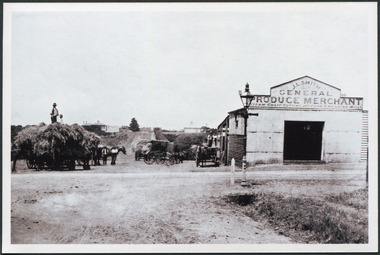 City of Moorabbin Historical Society (Operating the Box Cottage Museum)
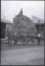
Photograph, Black & White J. L. Smith Hay & Grain Store Bentleigh c1910, c1910
... Gates' on Point Nepean Road and Dendy Street. East Brighton... Smith was born at their home near the 'Toll Gates' on Point ...John Logan Smith 1860-1932 , the son of Irish immigrants James and Marianne Smith was born at their home near the 'Toll Gates' on Point Nepean Road and Dendy Street. East Brighton. At that time the area had many orchards that were later replaced by market gardens. J.L.Smith at first rented a cottage 'Law Muir Den' & Shed from Mr Box and commenced business as a wood merchant - sawing logs into shorter pieces using one horse to power the saw. He purchased the property, added to the buildings , began trading in fuel and fodder as well and installed a chaff cutting mill powered by 10hp steam engine. The business prospered 1909 following the death of Tommy Bent, J/L Smith was nominated for Councillor of the Shire of Moorabbin. WW1 1914 - 18 both John and Mary Ann supported local War Relief Auxiliaries and their son Vic served as a Signaler in AIF. As Motor transport was increasing 1926 J L Smith built a small Garage on the opposite corner (Woolworths Supermarket 2005) , employed a good mechanic ( Reg Hunt ) and developed another successful business. The Grain Store was managed by family until 1930. In 1932 JL Smith assisted a man whose car had broken down, pushing it to the garage and sadly suffered a heart attack and died. He is buried in Cheltenham Cemetery. J.L.Smith was an early settler in East Brighton now Bentleigh and established successful Wood cutting, Grain & Chaff cutting and Motor garage businesses in Centre Road . He was elected Councillor of the Shire of Moorabbin and, with Mary Ann, his family were involved with local Church, Red Cross, and other community organizations.Black & white photograph of the Hay & Grain Store of John Logan Smith 1860-1932 on the corner of Jasper Rd and Centre Rd Bentleigh ( East Brighton) c1910. A Horse drawn cart loaded with hay and another outside the first building used by J L Smith -
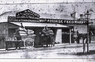 City of Moorabbin Historical Society (Operating the Box Cottage Museum)
Photograph, Black & White, J.L.Smith Hay & Grain Store c1916 Bentleigh, 1916
... Gates' on Point Nepean Road and Dendy Street. East Brighton... Smith was born at their home near the 'Toll Gates' on Point ...John Logan Smith 1860-1932 , the son of Irish immigrants James and Marianne Smith was born at their home near the 'Toll Gates' on Point Nepean Road and Dendy Street. East Brighton. At that time the area had many orchards that were later replaced by market gardens. J.L.Smith at first rented a cottage 'Law Muir Den' & Shed from Mr Box and commenced business as a wood merchant - sawing logs into shorter pieces using one horse to power the saw. He purchased the property, added to the buildings , began trading in fuel and fodder as well and installed a chaff cutting mill powered by 10hp steam engine. The business prospered 1909 following the death of Tommy Bent, J/L Smith was nominated for Councillor of the Shire of Moorabbin. WW1 1914 - 18 both John and Mary Ann supported local War Relief Auxiliaries and their son Vic served as a Signaler in AIF. As Motor transport was increasing 1926 J L Smith built a small Garage on the opposite corner (Woolworths Supermarket 2005) , employed a good mechanic ( Reg Hunt ) and developed another successful business. The Grain Store was managed by family until 1930. In 1932 JL Smith assisted a man whose car had broken down, pushing it to the garage and sadly suffered a heart attack and died. He is buried in Cheltenham Cemetery J.L.Smith was an early settler in East Brighton now Bentleigh and established successful Wood cutting, Grain & Chaff cutting and Motor garage businesses in Centre Road . He was elected Councillor of the Shire of Moorabbin and, with Mary Ann, his family were involved with local Church, Red Cross, and other community organizations.Black & White photograph of J L Smith Hay & Grain Store and Crushing Mill Jasper Rd / Centre Rd Bentleigh 1916. A veranda has been added to the store, new signage attached and a Gas light and hitching post are in foreground. 3 Horse drawn carts loaded with grain bags and drivers sitting on top of loadV. Smithgas street light, hitching posts, smith vic, photography, smith j l; smith mary ann, stanley helen, smith vic, smith harry redvers, chaff cutter, horse drawn carts, toll gates brighton, motor cars 1900, steam engines, early settlers, bentleigh, parish of moorabbin, city of moorabbin, county of bourke, moorabbin roads board, shire of moorabbin, henry dendy's special survey 1841, were j.b.; bent thomas, o'shannassy john, king richard, charman s, highett william, ormond francis, maynard dennis, market gardeners, vineyards, orchards -
 City of Moorabbin Historical Society (Operating the Box Cottage Museum)
Photographs, x 2 ,Black & White, F Smith Horse drawn cart loaded, Baled Straw, Grain, c1920
... Gates' on Point Nepean Road and Dendy Street. East Brighton... Smith was born at their home near the 'Toll Gates' on Point ...John Logan Smith 1860-1932 , the son of Irish immigrants James and Marianne Smith was born at their home near the 'Toll Gates' on Point Nepean Road and Dendy Street. East Brighton. At that time the area had many orchards that were later replaced by market gardens. J.L.Smith at first rented a cottage 'Law Muir Den' & Shed from Mr Box and commenced business as a wood merchant - sawing logs into shorter pieces using one horse to power the saw. He purchased the property, added to the buildings , began trading in fuel and fodder as well and installed a chaff cutting mill powered by 10hp steam engine. The business prospered 1909 following the death of Tommy Bent, J/L Smith was nominated for Councillor of the Shire of Moorabbin. WW1 1914 - 18 both John and Mary Ann supported local War Relief Auxiliaries and their son Vic served as a Signaler in AIF. As Motor transport was increasing 1926 J L Smith built a small Garage on the opposite corner (Woolworths Supermarket 2005) , employed a good mechanic ( Reg Hunt ) and developed another successful business. The Grain Store was managed by family until 1930. In 1932 J L Smith assisted a man whose car had broken down, pushing it to the garage and sadly suffered a heart attack and died. He is buried in Cheltenham Cemetery. J.L.Smith was an early settler in East Brighton now Bentleigh and established successful Wood cutting, Grain & Chaff cutting and Motor garage businesses in Centre Road . He was elected Councillor of the Shire of Moorabbin and, with Mary Ann, his family were involved with local Church, Red Cross, and other community organizations.2 x Black & White photographs showing horse drawn carts loaded with (a) Hay and (b) bags of grain outside J.L.Smith Grain & Chaff Store Centre Rd Bentleigh c1920smith frank, smith arch, smith tom, smith j l; smith mary ann, stanley helen, smith vic, smith harry redvers, chaff cutter, horse drawn carts, toll gates brighton, motor cars 1900, steam engines, early settlers, bentleigh, parish of moorabbin, city of moorabbin, county of bourke, moorabbin roads board, shire of moorabbin, henry dendy's special survey 1841, were j.b.; bent thomas, o'shannassy john, king richard, charman s, highett william, ormond francis, maynard dennis, market gardeners, vineyards, orchards -
 Nepean Historical Society
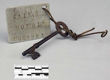
Functional object - Key with Tag
... in Sydney. The following year, the couple settled in Point Nepean... in Sydney. The following year, the couple settled in Point Nepean ...This object features a key with a labelled tag attached to it. It was once the key to the well-known Nepean Hotel. Also known locally as 'The Castle', likely due to its grand size and turret-like tower, the Nepean Hotel was officially established in 1872 by James Sandle Ford (https://poi-australia.com.au/points-of-interest/australia/victoria/portsea/approximate-site-ford-family-nepean-hotel-c-1870-pt-nepean-rd-near-fitzjohns-crt-portsea-mornington-peninsula-vic/). Born in 1811, Ford was only nineteen years old when he was sentenced to seven years transportation for 'Machine Breaking' in 1830. (https://nepeanhistoricalsociety.asn.au/james-sandle-ford/). He arrived in Van Diemen's Land (Tasmania) in 1831 and served five years of his sentence, before being pardoned in 1836. Ford met and married Irish immigrant Hannah Sullivan in 1841 in Sydney. The following year, the couple settled in Point Nepean. Ford is often accredited with the naming of the town of Portsea - after Portsea in Hampshire, UK - and spent a lifetime establishing himself throughout the area. This included: lime burning, dairying, horse judging and breeding, and the cultivation of land and livestock. Ford died in 1890, however his hotel continued to operate for many decades, run by his descendants - including Julia Cain during the first half of the twentieth century (https://trove.nla.gov.au/newspaper/article/65817831) (https://trove.nla.gov.au/newspaper/article/3734533). The hotel was demolished in 1971. This object is significant as it is important in relation to the development and prosperity of the area of Point Nepean. A door key with a rusted surface. One end of the key features a single set of teeth with three notches. Attached to the other end is a rounded handle with a hole through the middle. Looped through the hole is a piece of thin, rusted wire. The wire is looped through both the key and a hole in a white square-shaped tag. Printed on the tag are the words: 'CAIN'S HOTEL PORTSEA'. CAIN'S HOTEL, PORTSEAnepean hotel, cain family, james ford, james sandle ford, portsea hotel