Showing 69 items matching "port phillip pioneers"
-
 Greensborough Historical Society
Book, David Hay, In Their Own Words: a glimpse of life in the formative years of the Colony of Port Phillip, 2015
This family history describes life in the colony of Port Phillip (Melbourne) as documented by pioneers of the Reid family who settled at Hazelglen, now Doreen. This history compiled by descendant David Hay.Paperback book with text and colour Imagesaustralian history, port phillip district, reid family, patrick reid, agnes reid, doreen -
 Clunes Museum
Book - DIARY, PETER KEMPSON, A PIONEER'S JOURNEY TO EARLY PORT PHILLIP, 1998
... TO EARLY PORT PHILLIP. THE DIARY OF PETER KEMPSON 1848 - 1849... A PIONEER'S JOURNEY TO EARLY PORT PHILLIP Book DIARY PETER KEMPSON ...THE DIARY OF PETER KEMPSON 1848 - 1849WHITE COVER WITH BLACK PLASTIC SPINE. A PIONEER'S JOURNEY TO EARLY PORT PHILLIP. THE DIARY OF PETER KEMPSON 1848 - 1849non-fictionTHE DIARY OF PETER KEMPSON 1848 - 1849local history, documents, diary, kempson, peter, diary -
 Whitehorse Historical Society Inc.
Document, Nunawading Orchardists, ?
... . Pastoral Pioneers of the Port Phillip District. Amendment C157 City.... Pastoral Pioneers of the Port Phillip District. Amendment C157 City ...Lists of Nunawading orchardists from 1894non-fictionLists of Nunawading orchardists from 1894nunawading, orchardists, orchards -
 Eltham District Historical Society Inc
Photograph - Digital Photograph, Alan King, Blue Lake, Plenty Gorge Park, 2008
A quarry was transformed into the Blue Lake. Published: Nillumbik Now and Then / Marguerite Marshall 2008; photographs Alan King with Marguerite Marshall.; p179 The dramatic steep-sided Plenty Gorge lies along the divide of two geological areas, and separates the Nillumbik Shire and the City of Whittlesea. On the Nillumbik side are undulating hills and sedimentary rock, and in Whittlesea, lies a basalt plain formed by volcanic action up to two million years ago. This provides the Plenty Gorge Park with diverse vegetation and habitats, making it one of Greater Melbourne’s most important refuges for threatened and significant species. The park, established in 1986, consists of around 1350 hectares, and extends 11 kilometres along the Plenty River, from Greensborough to Mernda. It provides a wildlife corridor for around 500 native plant and 280 animal species. The area’s plentiful food and water attracted the Wurundjeri Aboriginal people and then European settlers. By 1837 squatters had claimed large runs of land for their sheep and cattle. The Plenty Valley was among the first in the Port Phillip District to be settled - mainly in the less heavily timbered west - and was proclaimed a settled district in 1841.But by the late 1880s, the settlers’ extensive land clearing for animal grazing, then agriculture, depleted the Wurundjeri’s traditional food sources, which helped to drive them away. Many Wurundjeri artefacts remain (now government protected), and so far 57 sites have been identified in the park, including scarred trees, burial areas and stone artefacts. Pioneer life could be very hard because of isolation, flooding, bushfires and bushrangers. Following the Black Thursday bushfires of 1851, basalt was quarried to build more fire-resistant homes. Gold discoveries in the early 1850s swelled the population, particularly around Smugglers Gully; but food production made more of an impact. In the late 1850s wheat production supplanted grazing. In the 1860s the government made small holdings available to poorer settlers. These had the greatest effect on the district, particularly in Doreen and Yarrambat, where orchards were established from the 1880s to 1914. Links with a prominent early family are the remains of Stuchbery Farm, by the river’s edge bounded by Smugglers Gully to the north and La Trobe Road, Yarrambat, to the east. The Stuchberys moved to the valley in 1890, and the family still lives in the area. In 1890, Alfred and Ada first lived in a tent where four children were born, then Alfred built the house and outbuildings around 1896. They planted an orchard, then a market garden, and developed a dairy. The family belonged to the local Methodist and tennis communities. Their grandson Walter, opened the Flying Scotsman Model Railway Museum in Yarrambat, which his widow, Vi, continues to run. Wal was also the Yarrambat CFA Captain for 22 years until 1987. Walter sold 24 hectares in 1976 for development - now Vista Court - and in 1990, the remaining 22.6 hectares for the park. Remaining are an early stone dairy and remnants of a stone barn, a pig sty and a well. Until it was destroyed by fire in 2003, a slab hut stood on the Happy Hollow Farm site, at the southern end of the park. The hut is thought to have been built in the Depression around 1893. This was a rare and late example of a slab hut with a domestic orchard close to Melbourne. Emmet Watmough and his family first occupied the hut, followed by a succession of families, until the Bell family bought it around 1948. There they led a subsistence lifestyle for 50 years, despite encroaching Melbourne suburbia. The Yellow Gum Recreation Area includes the Blue Lake, coloured turquoise at certain times of the year. Following the 1957 bushfires, this area was quarried by Reid Quarries Pty Ltd for Melbourne’s first skyscrapers, then by Boral Australia. However in the early 1970s water began seeping into the quarry forming the Blue Lake and the quarry was closed. The State Government bought the site in 1997 and opened it as a park in 1999.This collection of almost 130 photos about places and people within the Shire of Nillumbik, an urban and rural municipality in Melbourne's north, contributes to an understanding of the history of the Shire. Published in 2008 immediately prior to the Black Saturday bushfires of February 7, 2009, it documents sites that were impacted, and in some cases destroyed by the fires. It includes photographs taken especially for the publication, creating a unique time capsule representing the Shire in the early 21st century. It remains the most recent comprehenesive publication devoted to the Shire's history connecting local residents to the past. nillumbik now and then (marshall-king) collection, blue lake, plenty gorge park -
 Eltham District Historical Society Inc
Photograph - Digital Photograph, Marguerite Marshall, Stuchbery Farm dairy, 14 March 2008
Stuchbery Farm was situated on the Plenty River bounded by Smugglers Gully to the north and La trobe Road, Yarrambat, to the east. Alan and Ada Stutchbery moved to the valley in 1890, first living in a tent where four children were born. Alfred built a home and outbuildings around 1896. They planted an orchard, then a market garden and developed a dairy. Published: Nillumbik Now and Then / Marguerite Marshall 2008; photographs Alan King with Marguerite Marshall.; p179 The dramatic steep-sided Plenty Gorge lies along the divide of two geological areas, and separates the Nillumbik Shire and the City of Whittlesea. On the Nillumbik side are undulating hills and sedimentary rock, and in Whittlesea, lies a basalt plain formed by volcanic action up to two million years ago. This provides the Plenty Gorge Park with diverse vegetation and habitats, making it one of Greater Melbourne’s most important refuges for threatened and significant species. The park, established in 1986, consists of around 1350 hectares, and extends 11 kilometres along the Plenty River, from Greensborough to Mernda. It provides a wildlife corridor for around 500 native plant and 280 animal species. The area’s plentiful food and water attracted the Wurundjeri Aboriginal people and then European settlers. By 1837 squatters had claimed large runs of land for their sheep and cattle. The Plenty Valley was among the first in the Port Phillip District to be settled - mainly in the less heavily timbered west - and was proclaimed a settled district in 1841. But by the late 1880s, the settlers’ extensive land clearing for animal grazing, then agriculture, depleted the Wurundjeri’s traditional food sources, which helped to drive them away. Many Wurundjeri artefacts remain (now government protected), and so far 57 sites have been identified in the park, including scarred trees, burial areas and stone artefacts. Pioneer life could be very hard because of isolation, flooding, bushfires and bushrangers. Following the Black Thursday bushfires of 1851, basalt was quarried to build more fire-resistant homes. Gold discoveries in the early 1850s swelled the population, particularly around Smugglers Gully; but food production made more of an impact. In the late 1850s wheat production supplanted grazing. In the 1860s the government made small holdings available to poorer settlers. These had the greatest effect on the district, particularly in Doreen and Yarrambat, where orchards were established from the 1880s to 1914. Links with a prominent early family are the remains of Stuchbery Farm, by the river’s edge bounded by Smugglers Gully to the north and La Trobe Road, Yarrambat, to the east. The Stuchberys moved to the valley in 1890, and the family still lives in the area. In 1890, Alfred and Ada first lived in a tent where four children were born, then Alfred built the house and outbuildings around 1896. They planted an orchard, then a market garden, and developed a dairy. The family belonged to the local Methodist and tennis communities. Their grandson Walter, opened the Flying Scotsman Model Railway Museum in Yarrambat, which his widow, Vi, continues to run. Wal was also the Yarrambat CFA Captain for 22 years until 1987. Walter sold 24 hectares in 1976 for development - now Vista Court - and in 1990, the remaining 22.6 hectares for the park. Remaining are an early stone dairy and remnants of a stone barn, a pig sty and a well. Until it was destroyed by fire in 2003, a slab hut stood on the Happy Hollow Farm site, at the southern end of the park. The hut is thought to have been built in the Depression around 1893. This was a rare and late example of a slab hut with a domestic orchard close to Melbourne. Emmet Watmough and his family first occupied the hut, followed by a succession of families, until the Bell family bought it around 1948. There they led a subsistence lifestyle for 50 years, despite encroaching Melbourne suburbia. The Yellow Gum Recreation Area includes the Blue Lake, coloured turquoise at certain times of the year. Following the 1957 bushfires, this area was quarried by Reid Quarries Pty Ltd for Melbourne’s first skyscrapers, then by Boral Australia. However in the early 1970s water began seeping into the quarry forming the Blue Lake and the quarry was closed. The State Government bought the site in 1997 and opened it as a park in 1999.This collection of almost 130 photos about places and people within the Shire of Nillumbik, an urban and rural municipality in Melbourne's north, contributes to an understanding of the history of the Shire. Published in 2008 immediately prior to the Black Saturday bushfires of February 7, 2009, it documents sites that were impacted, and in some cases destroyed by the fires. It includes photographs taken especially for the publication, creating a unique time capsule representing the Shire in the early 21st century. It remains the most recent comprehenesive publication devoted to the Shire's history connecting local residents to the past. nillumbik now and then (marshall-king) collection, ada stuchbery, alan stuchbery, dairy, stuchbery farm, farm buildings, yarrambat, plenty gorge park -
 Clunes Museum
Photograph, ca1861
When Richard Daintree rejoined the Victorian Geological Survey as a field surveyor in January 1859, he pioneered the use of photography in field-work. The glass plates attributed to him by the State Library of Victoria show four images of the mines in Clunes, Victoria, Australia in the 1860'sBlack and white reproduction of Port Phillip Colonial & Gold Mining Co., Clunes, Victoria, Australia in a light wood timber frameOn Reverse: Handwritten in pencil Port Phillip Co. 1860's Nettleton Photography glass plate Latrobe Libraryport phillip and colonial gold mining co., richard daintree -
 Narre Warren and District Family History Group
Book, Alfred Joyce, A homestead history : being the reminiscences and letters of Alfred Joyce of Plaistow and Norwood, Port Phillip, 1843 to 1864, 1969
A HOMESTEAD HISTORY Alfred Joyce began a pastoral partnership with his brother in the Upper Loddon early in 1844. His reminiscences reveal events of the venture, from the departure from Melbourne with the completion of a roomy homestead, from the threat of bankruptcy, to substantial success within a decade. In writing them, he was not dependent upon his memories; the many letters he had written to his parents in London had eventually been returned to him, and those written between 1851 and his mother's death in 1858 form a continuation of his own narrative. They describe in vivid detail the upheavals that followed the discovery of gold, the transformation of both town and country, the dissolution of the Joyce brothers' partnership, and Alfred's activities as pastoralist, farmer and miller at Norwood on die Bet Bet Creek. In this third edition, for which a much wider range of illustrations is available, an epilogue continues the story of George Joyce at Plaistow and Alfred Joyce at Norwood until both properties had passed into other hands. Domestic tragedy overwhelmed the one, while droughts and mortgages eventually ruined the other. It is a record which, in the words of the American Historical Review, 'would serve as script for a first-class documentary film and deserves high rank, in the literature of pastoral pioneering'. Other reviewers have been equally emphatic: 'The real history of Australia is written very largely in such records as this' (Australian Quarterly); 'of historical documents such as diese we cannot have too many' (Sydney Morning Herald). (back cover)non-fictionA HOMESTEAD HISTORY Alfred Joyce began a pastoral partnership with his brother in the Upper Loddon early in 1844. His reminiscences reveal events of the venture, from the departure from Melbourne with the completion of a roomy homestead, from the threat of bankruptcy, to substantial success within a decade. In writing them, he was not dependent upon his memories; the many letters he had written to his parents in London had eventually been returned to him, and those written between 1851 and his mother's death in 1858 form a continuation of his own narrative. They describe in vivid detail the upheavals that followed the discovery of gold, the transformation of both town and country, the dissolution of the Joyce brothers' partnership, and Alfred's activities as pastoralist, farmer and miller at Norwood on die Bet Bet Creek. In this third edition, for which a much wider range of illustrations is available, an epilogue continues the story of George Joyce at Plaistow and Alfred Joyce at Norwood until both properties had passed into other hands. Domestic tragedy overwhelmed the one, while droughts and mortgages eventually ruined the other. It is a record which, in the words of the American Historical Review, 'would serve as script for a first-class documentary film and deserves high rank, in the literature of pastoral pioneering'. Other reviewers have been equally emphatic: 'The real history of Australia is written very largely in such records as this' (Australian Quarterly); 'of historical documents such as diese we cannot have too many' (Sydney Morning Herald). (back cover)alfred joyce, upper loddon -
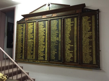 Kew Historical Society Inc
Memorabilia, MUIOOF: Port Phillip District/Yarra Yarra District Honour Board, 1930
The MUIOOF Lodge was located in Union Street, Kew. The Lodge was established in 1863. It was demolished in the early 1990s.The Lodge Board lists the names of representatives of many of Kew's pioneering families. The Board was donated to the Society when the Hall was demolished. MUIOOF Lodge Board - Yarra Yarra District, Loyal Kew Lodge No. 5093 Port Phillip District till 1888 / Yarra Yarra District from 1888 Past Grands [listed] W.Woolard 1864 to A.E. Martin 1990 Maker marks - [Painted on back panel] "Lodge Board - Written by Bro. J. Kleiner, Signwriter 432 Burwood Rd. Glenferrie March 1930".[Engraved on pediment] "G.E. Gosbell, Woodcarver 1955". muioof (kew), yarra yarra district, port phillip district, j. kleiner, manchester unity independent order of oddfellows, w. woollard, d. gray, g. taylor, d. dannock, e.g. backwell, s. conder, j.h. joyce, r. summers, r. clulow, w. morris, f. fanhauser, j. waters, w. butson, a. dalton, t.g. jellis, j. watson, w. howieson, a.h. alexander, w.h. perry, a.r. studd, t. greenhill, w.a. hunt, w. maslen, t. eakins, h. ellis, a. geoffrey, j. priestman, t.e. morrisjamieson, c.h. bryan, g. hinchcliffe, t. foley, a.j. conder, s. clapham, a. cornish, f.j. fauvel, e.m. bond, h. co, j.g m. moller, e. hillier, w. finucane, w.e. bristow, v. geoffrey, a. hill, j.t. studd, h. de c. kellett, a.j whittaker, e. foley, e.f. fordred, p.j. ridgeway, j. barnard, h.a. ingham, h. woollard, j.w. fuller, e. mclean, p.g. pearce, f. walsh, h. fryar, h. salisbury, h. woolard, h.c. cox, a.j. watson, w. holt, f.t. james, e.c. parry, g. lees, h.o. ada,s, g.c. barclay, g.h. mockridge, g. philpott, j. corser, a. lilburn, w.p. wheeler, t.e. morri, r.r. clarke, h.d. sisson, w.r. harle, w.g. gray, j.d. newman, c.w. laidler, e.a. rae, a.a. homes, a. mcconachie, h.f. woollard, p.g. gallop, h.c. nelson, l.n. graebe, e.w. firth, n. rae, r.j. kelly, j. donaldson, f.t. jmes, c. till, t.j. doyle, s.m.f wills, w.l. smith, h. mcallan, h.a. morgan, a. kinns, w.r. adams, c.h. jones, g.h. carter, m. prout, a.w. bishop, k.c. hemmings, e.k. sparls, l.m. harle, j.m. prout, l.e. watts, d.b. adams, f.u. woolard, a. macrae, n.l. gration, d.h. vickers, m.h.m. alister, t.a. till, r.w. bent, j.w. woolard, a.e. woolard, r.h. harle, jean harle, l.o. adams, d.h. lloyd, k.w. harle, d.g. mclean, p.s. pearse, v.l. profitt, f.c. marks, m.h. mcalister, j. newman, e.m. savory, a.f gration, c.g. teasdale, e.k. sparkes, a.j. scott, w.h. savory, t.r. holland, g.t. smith, d. adams, s. rowe, t. bentley, l.e. fegan, m.j. fiander, g.n. bentley, j.l. oakley, h. brierley, b. oakley, m. j. fiander, w. humphries, a. weingardt, c. nunn, d.a. adams, s.p. clark, s. evans, g.n.bentley, s. clugston, d.c. mitchell, a.e. martin, g.n bentley, l.b. murrell, t.b. will, d. murrell -
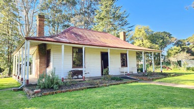 Old Gippstown
Building - Bushy Park
13 August 1843 First application for the Bushy Park run appeared in the “Port Phillip Gazette”. It was taken up by Angus McMillan, who took up the Boisdale run across the Avon River at the same time, for his employer Lachlan Macalister. This house was built in 1848. March 1844 Licence to Bushy Park granted to McMillan. It consisted of 16,000 acres. Late 1840s Bushy Park homestead built for McMillan by Andrew Martin and Matt McCraw. High local historic significance as associated with major pioneer and a very old white settlement in Gippsland.A square shaped timber house, with a corrugated iron roof over shingles. It has a verandah that covers both the front and sides of the house. The house is contructed of redgum timber, and internally has four rooms.National Trust of Australia Plaque - Bushy Park Homestead - Class 'C'mcmillan, angus, old gippstown, west gippsland, gippsland, gippsland heritage park, goldfields, victorian era, moe, historical village, wellington shire, avon river, boisedale, briagolong, dargo, murdoch mackintosh, national trust, andrew martin and matt mccraw., latrobe valley, old gippstown heritage park, gunaikurnai, latrobe city council