Showing 18482 items
matching portland-freezing-works
-
 Glenelg Shire Council Cultural Collection
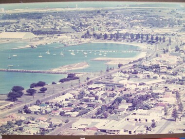
Photograph - Photograph - Portland Foreshore, n.d
Glenelg Shire Council RecordsAerial view of Portland foreshore.Front: (no inscriptions) Back: Portland Studios/11 Julia St., Portland 3305. Tel. 232224 (black stamp centre top). Portland Development Committee Archive Material (black pen, upper centre). Portland Development Committee Inc. (blue ink stamp, centre).portland foreshore -
 Glenelg Shire Council Cultural Collection
Banner - Banner - Yesterday's Foundations, Nov-10
port of portland archives -
Glenelg Shire Council Cultural Collection
Banner - Banner - The Heart of our Region, Nov-10
-
Glenelg Shire Council Cultural Collection
Banner - Banner - Tomorrow's Possibilities, Nov-10
-
Glenelg Shire Council Cultural Collection
Photograph, View across North Portland to Bridgewater Bay, 1968
Port of Portland Authority archives.Front: (no inscriptions) Back: LOOKING ACROSS NORTH PORTLAND TOWARDS BRIDGEWATER BAY JULY. 1968port of portland, bridgewater bay, wool stores -
Glenelg Shire Council Cultural Collection
Functional object - Sticker, PORTLAND 150th, n.d
Portland celebrated the 150th anniversary of its formation as a town in 1984. A number of commemorative items were produced.Oblong-shaped promotional sticker, promoting Portland's 150th celebrations in 1984. Black text printed on white background, plus logo of whale in triangle with blue green wave designs.Front: Portland's 150th Anniversary 1934-1984 Victoria's First Permanent Settlement150th, 1984, 1934, sticker, commemorative, celebration -
 Glenelg Shire Council Cultural Collection
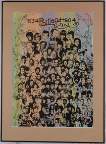
Print, 1834-Portland-1984, 1984
Print was part of "A Community View, 150 years in Portland Screenprint Exhibition." Part of CEMA Art Collection. Part of Angela Gee residency workshops, 1983 and 1984.Image of approximately 125 people's faces and two dogs, surrounded by a border of line-drawn flowers, leaves and stems. At top centre are the words "1834 Portland 1984" with a decorative underline in bold alluding to the shape of the Portland Bay and Cape Nelson. Background colours are in vertical swathes: aqua, pale green, apricot, blue, mauve, pink, turquiose.Front: (no inscriptions) Back: Portland C.S.P. (Community Screen Print) Design Studio 1983-1985. Initiated by C.E.M.A., Portland Access Printshop and Anne O'Kane, C.A.O. Purpose - an employment project to train 5 people in print-making, costume and design. A grant of $200,000 was obtained from the Commonwealth Employment Program; the products - costumes, flags, posters, banners - were used for Portlands 150th Anniversary Celebrations.angela gee, portland centenary, 1984, screenprint, cema, female artist, female artists -
 Flagstaff Hill Maritime Museum and Village
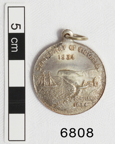
Medal - Commemorative, Centenary of Victoria, Melbourne and Portland, 1935
This commemorative medal celebrates a colonisation of two towns, now cities, in Victoria; Melbourne and Portland. The medal shows the significance placed on the colonisation of Victoria and the growth of the hundred year period. Medal, silver. with hole and ring at the top. Obverse: Sailing Ship, Coast, Boat on shore, 3 men. Reverse Colonial man on grass, river, city buildings on other river bank Medal commemorates the centenary of Victoria and Portland 1834 and Melbourne 1835. "CENTENARY OF VICTORIA 1934" & "PORTLAND 1834", "CENTENARY OF MELBOURNE 1935" & "1835" flagstaff hill, warrnambool, shipwrecked-coast, flagstaff-hill, flagstaff-hill-maritime-museum, maritime-museum, shipwreck-coast, flagstaff-hill-maritime-village, medal, centenary medal, centenary of victoria, centenary of melbourne, 1834-1934, 1835-1935, colonial, centenary of portland, colonisation of victoria -
 Glenelg Shire Council Cultural Collection
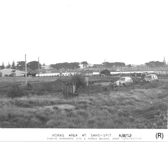
Photograph - Photograph - Portland Harbour Trust - Works area at Sand-spit, 6.8.52, 1952
Port of Portland Authority archivesFront: WORKS AREA AT SAND-SPIT. 6/8/52/ SHOWING WORKSHOPS' SITE & STORES BUILDING UNDER CONSTRUCTION (lower centre) Back: P.H.T./ Print No. 3/3 Neg. No // Date taken 6-8-52./ SUBJECT./ % (Ink stamp with blue pen and pencil additions, centre)port of portland archives -
 Kew Historical Society Inc
Plan, Melbourne & Metropolitan Board of Works : Borough of Kew : Detail Plan No.1302, 1910
The Melbourne and Metropolitan Board of Works (MMBW) plans were produced from the 1890s to the 1950s. They were crucial to the design and development of Melbourne's sewerage and drainage system. The plans, at a scale of 40 feet to 1 inch (1:480), provide a detailed historical record of Melbourne streetscapes and environmental features. Each plan covers one or two street blocks (roughly six streets), showing details of buildings, including garden layouts and ownership boundaries, and features such as laneways, drains, bridges, parks, municipal boundaries and other prominent landmarks as they existed at the time each plan was produced. (Source: State Library of Victoria)This plan forms part of a large group of MMBW plans and maps that was donated to the Society by the Mr Poulter, City Engineer of the City of Kew in 1989. Within this collection, thirty-five hand-coloured plans, backed with linen, are of statewide significance as they include annotations that provide details of construction materials used in buildings in the first decade of the 20th century as well as additional information about land ownership and usage. The copies in the Public Record Office Victoria and the State Library of Victoria are monochrome versions which do not denote building materials so that the maps in this collection are invaluable and unique tools for researchers and heritage consultants. A number of the plans are not held in the collection of the State Library of Victoria so they have the additional attribute of rarity.Original survey plan, issued by the MMBW to a contractor with responsibility for constructing sewers in the area identified on the plan within the Borough of Kew. The plan was at some stage hand-coloured, possibly by the contractor, but more likely by officers working in the Engineering Department of the Borough and later Town, then City of Kew. The hand-coloured sections of buildings on the plan were used to denote masonry or brick constructions (pink), weatherboard constructions (yellow), and public buildings (grey). The absence of buildings and or property in Kew facing the Yarra is the most notable feature of this plan. Walmer Street and its bridge stretched, then and now, from Studley Park Road to Victoria Street, Richmond. On the Richmond side of the Yarra, there was evidence in 1904 of industry (‘Wool shed’; Soap Works’) and entertainment (‘Skittle Alley’). In reality, another Plan (No.1303) shows Chinese Gardens bordering the Yarra on the Kew side and buildings in Young Street.melbourne and metropolitan board of works, detail plans, mmbw 1302, cartography -
Glenelg Shire Council Cultural Collection
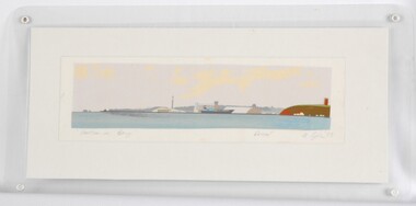
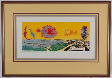
Print, Portland Pier, 1983
CEMA Art Collection Part of "A Community View" 150 years in Portland Screenprint Exhibition. Part of Angela Gee Residency 1983 and 1984.Laminated screenprint depicting a panoramic view of Portland Harbour and coastline in lower half. Top half of work features five enlarged sea creatures on a yellow background. The creatures are (from left to right): two seahorses; a side view of a fish; a bug; and a front view of a fish.Front: Portland Pier 32/70 A Gee 83 Back: 11 -
Glenelg Shire Council Cultural Collection
Photograph - Photograph - Thomas Borthwick and Sons abattoirs and Australian Estates wool stores, 1968
Port of Portland Authority archives.Front: (no inscriptions) Back: OPEN COUNTRY WEEST OF THE HENTY HIGHWAY AT NORTH PORTLAND JAN 1968/ PORTLAND HARBOUR TRUST COMMISSIONERSport of portland archives -
 Glenelg Shire Council Cultural Collection
Print, Portland Bay, 1983
CEMA Art Collection Part of "A Community View" 150 years in Portland Screenprint Exhibition Part of Angela Gee Residency 1983 and 1984Laminated screenprint of Portland Bay. Wide angle view of the Bay, with water tower / lighthouse on the right, the harbour with a docked ship in the centre, and the end of the peninsular and ocean on the left.Front: "Portland Bay" (lower left) Proof (lower right centre) A Gee '83 (lower right) (pencil) Back: 12 -
 Warrnambool and District Historical Society Inc.
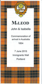
Document, McLeod Immigrants wall Portland, 2015
This is a brochure commemorating the arrival in Australia of John and Isabella McLeod and the unveiling of a plaque at the Immigrants Wall in Portland in 2015. The Immigrants Wall is located in Bentinck Street in Portland, Victoria and was a Glenelg Shire Bicentenary Project to enable descendants of those who first set foot on Australian soil at Portland to commemorate this event by placing a memorial plaque on the wall. John and Isabella McLeod were two of these immigrants to come to Portland in 1854. They came from the Isle of Raasay in Scotland and they and their families settled in areas around Warrnambool (Purnim, Port Fairy, Framlingham, Rosebrook etc)This brochure is of some interest as giving some information on John and Isabella McLeod and their families who came to Portland in 1854 and settled in areas around Warrnambool. These McLeods are ancestors of Graeme McLeod, a Warrnambool and District Historical Society memberThis is an A3 sheet folded three times. It has printed information on the Immigrants Wall at Portland and on John and Isabella McLeod. The front page has an outline of the McLeod tartan and the clan badge. The pages include colour photographs and a McLeod family tree.Front page: ‘McLeod, John & Isabella, Commemoration of arrival in Australia, 1854, 7 June 2015, Immigrants Wall, Portland’john and isabella mcleod, immigrants wall, portland, warrnambool -
 Kew Historical Society Inc
Plan, Melbourne & Metropolitan Board of Works : Borough of Kew : Detail Plan No.1590, 1905
The Melbourne and Metropolitan Board of Works (MMBW) plans were produced from the 1890s to the 1950s. They were crucial to the design and development of Melbourne's sewerage and drainage system. The plans, at a scale of 40 feet to 1 inch (1:480), provide a detailed historical record of Melbourne streetscapes and environmental features. Each plan covers one or two street blocks (roughly six streets), showing details of buildings, including garden layouts and ownership boundaries, and features such as laneways, drains, bridges, parks, municipal boundaries and other prominent landmarks as they existed at the time each plan was produced. (Source: State Library of Victoria)This plan forms part of a large group of MMBW plans and maps that was donated to the Society by the Mr Poulter, City Engineer of the City of Kew in 1989. Within this collection, thirty-five hand-coloured plans, backed with linen, are of statewide significance as they include annotations that provide details of construction materials used in buildings in the first decade of the 20th century as well as additional information about land ownership and usage. The copies in the Public Record Office Victoria and the State Library of Victoria are monochrome versions which do not denote building materials so that the maps in this collection are invaluable and unique tools for researchers and heritage consultants. A number of the plans are not held in the collection of the State Library of Victoria so they have the additional attribute of rarity.Original survey plan, issued by the MMBW to a contractor with responsibility for constructing sewers in the area identified on the plan within the Borough of Kew. The plan was at some stage hand-coloured, possibly by the contractor, but more likely by officers working in the Engineering Department of the Borough and later Town, then City of Kew. The hand-coloured sections of buildings on the plan were used to denote masonry or brick constructions (pink), weatherboard constructions (yellow), and public buildings (grey). Surveyed by the Board of Works in 1903 and published in 1904, Plan No.1590 shows development north of Cotham Road. While this plan includes built structures in Mary Street, Cotham Road, High Street, Park Hill Road, Kent Street, Ridgeway Avenue, and Ermington Lane (now Ermington Place), only part of this section was notated and coloured in this contractor’s copy. Numerous houses, large and small are named on the plan: ‘Cholula’, ‘Belper’, ‘The Uplands’, ‘Spring Grove’ facing Cotham Road; ‘Marion’ facing Kent Street; and ‘Kia Ora’ facing Ridgeway Avenue.melbourne and metropolitan board of works, detail plans, mmbw 1590, survey plans - borough of kew, cartography -
Glenelg Shire Council Cultural Collection
Print - Linocut - Admella Rescue Series No. 8, During the night the Portland lifeboat was launched, 2009
Part of suite of 16 Linocuts created for an exhibition at the Portland Arts centre for the Admella 150th Festival.Linocut print. Eighth in a suit of 16, of the Admella Resue Series. Depicts a man with a lantern, standing in the bow of the Portland Lifeboat, as it is being launched by several men with ropes. Printed in black on white archival paper.Front: Front - Linocut, Bob Stone 2009 'During the night the Portland lifeboat was launched.' - hand written, black penadmella, portland lifeboat, 150th anniversary, linocut -
 Ballarat Heritage Services
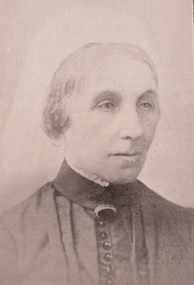
Photograph - Image, Mrs Stephen Henty of Portland
Stephen Henty married Jane Pace in Fremantle April 1836; four sons and six daughters were the issue of the marriage. Mrs. Stephen Henty was born in Yorkshire on 14 April 1812, and she died in Hamilton on 02 February 1906. She was the first white woman to settle permanently in Western Victoria, arriving in Portland on 18 December 1836. From a small booklet "Old Memories," written by Jane Henty on her 84th birthday. 'My husband and I arrived at Portland Bay in 1836, though he had made some trips there previously. It was on a Sunday night we landed by moonlight. I was carried on shore through the surf by a sailor. On reaching the homestead, a comfortable dwelling composed of four rooms, kitchen and dairy, a bright log fire was burning, table spread with a large pot loaf, piles of eggs and tea. Edward had not travelled inland, but my husband never rested until he had gone all through the interior, cut a track through 15 miles of forest land with two men and a dray, and arrived on the banks of the Wannon. He used to be absent for weeks at a time, causing me great anxiety. The natives were not to be trusted, so he usually took with him an expiree from Tasmania. Stephen Henty fixed all three of the first stations -Muntham, Merino Downs, and Sandford. In July 1837 Stephen sent some fine flocks of merino sheep to Muntham, having previously had a hut built for the men, and yards for the sheep; his two brothers, John and Frank, took charge of the sheep on the road. "On August 3, 1837, my son Richmond was born the very day the sheep arrived at Muntham. Edward was in Tasmania at the time, and arrived three weeks after the birth of my son, with his brother James and his son... My husband and Edward were in partnership, Edward managing Muntham, and Stephen the mercantile part at Portland Bay. John managed Sandford and Frank Merino Downs... My husband was the first white man who stood on the border of the Blue Lake at Mt. Gambier. He said he would never forget the feeling of awe he felt on coming suddenly on the blue water in the wilderness.("The Portland Bay Settlement", by Noel Learmonth, 1934)Black and white image Mrs Stephen Henty.stephen henty, portland, pioneer, women, jane henty, jane pace, merino downs -
 National Wool Museum
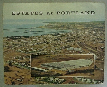
Booklet, Estates at Portland
Cover of booklet describing the Australian Estates Company building in Portland, Victoria, as well as a background on Portland."Estates at Portland"wool stores, australian estates company ltd -
 Kew Historical Society Inc
Plan, Melbourne & Metropolitan Board of Works / Borough of Kew, Detail Plan No.1593, 1905
The Melbourne and Metropolitan Board of Works (MMBW) plans were produced from the 1890s to the 1950s. They were crucial to the design and development of Melbourne's sewerage and drainage system. The plans, at a scale of 40 feet to 1 inch (1:480), provide a detailed historical record of Melbourne streetscapes and environmental features. Each plan covers one or two street blocks (roughly six streets), showing details of buildings, including garden layouts and ownership boundaries, and features such as laneways, drains, bridges, parks, municipal boundaries and other prominent landmarks as they existed at the time each plan was produced. (Source: State Library of Victoria)This plan forms part of a large group of MMBW plans and maps that was donated to the Society by the Mr Poulter, City Engineer of the City of Kew in 1989. Within this collection, thirty-five hand-coloured plans, backed with linen, are of statewide significance as they include annotations that provide details of construction materials used in buildings in the first decade of the 20th century as well as additional information about land ownership and usage. The copies in the Public Record Office Victoria and the State Library of Victoria are monochrome versions which do not denote building materials so that the maps in this collection are invaluable and unique tools for researchers and heritage consultants. A number of the plans are not held in the collection of the State Library of Victoria so they have the additional attribute of rarity.Original survey plan, issued by the MMBW to a contractor with responsibility for constructing sewers in the area identified on the plan within the Borough of Kew. The plan was at some stage hand-coloured, possibly by the contractor, but more likely by officers working in the Engineering Department of the Borough and later Town, then City of Kew. The hand-coloured sections of buildings on the plan were used to denote masonry or brick constructions (pink), weatherboard constructions (yellow), and public buildings (grey). The laborious task of hand-tinting these Board of Works plans was not without hazards as is evidenced by Plan No. 1593. On the Plan, the original colourist spilt black and green ink, partially obscuring some parts. The most obvious casualty is ‘Clifton’ located on the corner of Cotham Road and Park Street [now Adeney Avenue]. Included in this Plan, and outlined in pink is that part of the section that the contracting engineer was tasked with completing. This included sewering on both sides of this part of Cotham Road, but excluded properties such as ‘Glendonald’ and ‘Monnington’. This area was to undergo a series of subdivisions including the ‘Clifton Estate’, which created housing lots on Adeney Avenue and Florence Avenue in 1916. The most notable occupant of Clifton was William Adeney [died 1893], a pioneer of Camperdown, after which Park Street was later renamed.melbourne and metropolitan board of works, detail plans, survey plans - borough of kew, mmbw 1593, cartography -
Glenelg Shire Council Cultural Collection
Photograph, View of Portland Harbour, c. 1974
Port of Portland Authority archives.Front: (no inscriptions) Back: (no inscriptions)port of portland, south portland, portland harbour -
 Kew Historical Society Inc
Plan, Melbourne & Metropolitan Board of Works : Borough of Kew : Detail Plan No.1571, 1904
The Melbourne and Metropolitan Board of Works (MMBW) plans were produced from the 1890s to the 1950s. They were crucial to the design and development of Melbourne's sewerage and drainage system. The plans, at a scale of 40 feet to 1 inch (1:480), provide a detailed historical record of Melbourne streetscapes and environmental features. Each plan covers one or two street blocks (roughly six streets), showing details of buildings, including garden layouts and ownership boundaries, and features such as laneways, drains, bridges, parks, municipal boundaries and other prominent landmarks as they existed at the time each plan was produced. (Source: State Library of Victoria)This plan forms part of a large group of MMBW plans and maps that was donated to the Society by the Mr Poulter, City Engineer of the City of Kew in 1989. Within this collection, thirty-five hand-coloured plans, backed with linen, are of statewide significance as they include annotations that provide details of construction materials used in buildings in the first decade of the 20th century as well as additional information about land ownership and usage. The copies in the Public Record Office Victoria and the State Library of Victoria are monochrome versions which do not denote building materials so that the maps in this collection are invaluable and unique tools for researchers and heritage consultants. A number of the plans are not held in the collection of the State Library of Victoria so they have the additional attribute of rarity.Digital copy of the original survey plan, issued by the MMBW to a contractor with responsibility for constructing sewers in the area identified on the plan within the Borough of Kew. The plan was at some stage hand-coloured, possibly by the contractor, but more likely by officers working in the Engineering Department of the Borough and later Town, then City of Kew. The hand-coloured sections of buildings on the plan were used to denote masonry or brick constructions (pink), weatherboard constructions (yellow), and public buildings (grey). This plan is part of a large and historically significant group of MMBW plans and maps that was donated to the Society by the Mr Poulter, City Engineer of the City of Kew in 1989. When the contracts were let for surveyors to identify and record the extant houses and landscapes within an area for the Board of Works, the contracts were let at separate times, hence the anomaly where two copies of Plan No.1571 exist in our collection. The first of these plans identifies the building materials used in houses bordering Fitzwilliam Street, Edgevale Road, May Street, Malin Street, Davis Street and Wellington Street. The cut off point for the survey was the south side of Wellington Street. By 1903 when the survey was undertaken many of the sites were already built on, particularly those facing Edgevale Road. The plan identifies the preponderance of weatherboard houses in the area. The other version of the plan identifies the buildings between Wellington Street and Cotham Road.melbourne and metropolitan board of works, detail plans, mmbw 1571, cartography -
 Kew Historical Society Inc
Plan, Melbourne & Metropolitan Board of Works : Contour Plan of Melbourne & Suburbs : Melbourne Sewage, 1894
The Melbourne and Metropolitan Board of Works (MMBW) plans were produced from the 1890s to the 1950s. They were crucial to the design and development of Melbourne's sewerage and drainage system. This plan forms part of a large group of MMBW plans and maps that was donated to the Society by the Mr Poulter, City Engineer of the City of Kew in 1989. Within this collection, thirty-five hand-coloured plans, backed with linen, are of statewide significance as they include annotations that provide details of construction materials used in buildings in the first decade of the 20th century as well as additional information about land ownership and usage. The copies in the Public Record Office Victoria and the State Library of Victoria are monochrome versions which do not denote building materials so that the maps in this collection are invaluable and unique tools for researchers and heritage consultants. A number of the plans are not held in the collection of the State Library of Victoria so they have the additional attribute of rarity.Digital copy of an original MMBW plan. This contour plan shows the area identified by the MMBW for purposes of drainage and sewerage in 1894. The suburbs represented extend from Williamstown in the west to Bulleen in the east, and from Preston in the north, south to Sandringham. Suburbs are outlined in coloured ink. Red lines indicate main and branch sewers in existence at the beginning of 1894 in central and inner Melbourne. These extended as far as Williamstown and Brighton, but not yet as far as Kew, where sewering did not commence until 1901. Contour lines show the topography, which was important for indicating the fall of the land for the laying of sewers and drainage channels. Kew appears to be fairly undeveloped at this date except for railway lines and stations (the Kew and Outer Circle lines), main roads, the Kew Lunatic Asylum Reserve and Studley Park. However, the contour plan does not accurately represent the density of settlement, nor the large number of houses, which were being built in Kew and other suburbs from the 1850s to the land boom of the late 1880’s and early 1890’s. This plan is part of a large and historically significant group of MMBW plans and maps that was donated to the Society by the Mr Poulter, City Engineer of the City of Kew in 1989.mmbw contour plan of melbourne and suburbs, melbourne and metropolitan board of works, melbourne sewage, cartography -
Glenelg Shire Council Cultural Collection
Print - Linocut - Admella Rescue Series No. 13, Bob Stone, Help had reached the sufferers at last... Every heart will rejoice over this good news Portland Guardian 11th August 1859, 2009
Part of suite of 16 Linocuts created for an exhibition at the Portland Arts centre for the Admella 150th Festival.Linocut. Thirteenth in a suite of 16 in the Admella rescue series. Printed in black on white archival paper. Depicts 3 men on Admella, with a rope from them to the Portland lifeboat.Front: 'Linocut Bob Stone, 2009 Help had reached the sufferers at last... Every heart will rejoice over this good news Portland Guardian 11th August 1859' - Handwritten, black ink.admella, shipwreck, portland lifeboat -
 Melbourne Tram Museum
Document - Report, Parliamentary Public Works Committee, "Parliamentary Public Works Committee Report Plenty Road, Preston, Tramway Extension Enquiry, 1967
Report contained within a light brown card folder, containing a photocopy of report titled "Parliamentary Public Works Committee Report (including map) on The Plenty Road, Preston, Tramway Extension Enquiry - 1967". Report stapled in top right hand corner, 15 pages examining the extension of the East Preston route to Bolderwood Parade. Map shows extension proposed, bus routes, railway lines, streets - folded into 4.AETA stamp on front and inside sheet and "4E6" in ink on front cover. AETA stamp on the bottom right hand corner of the map.trams, tramways, east preston, new tramway, bolderwood parade, proposals -
 Lakes Entrance Historical Society
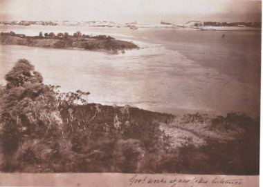
Photograph - New Works Lakes Entrance, 1885 c
Shows sand between timber piers at Entrance site, vegetation on Bullock Island, vegetation on hummocks is very sparse.Sepia toned photograph of New Works area prior to opening Lakes Entrance VictoriaGovernment Works at new Lakes Entrancesettlement, houses, waterways, gippsland lakes -
Hume City Civic Collection
Container - Flagon - wine, END OF AN ERA - WORKS DEPOT, pre 1994
The flagon with port was issued to recognise the end of the Shire of Bulla Works Depot. The port was from the Mt Aitken Estates in Gisborne. Public Works previously administered by the Shire of Bulla went out to private tendering.A cream and brown glazed flagon with sloping sides. The lower half of the flagon is cream with brown printing. The upper half and neck is brown. There is a black unbroken seal over the cork and the port is still in the flagon. On the front there is the Shire of Bulla insignia and on the back: the Shire of Bulla logo with the list of all employees of the Works Depot.on front: END OF AN ERA / (Shire of Bulla Insignia) / WORKS DEPOT / REMEMBER / "Safety is no Accident" shire of bulla, works depot, mt aitken vineyards, vineyards, ackland, b, adams, s, aksalih, b, aquilina, r, bartley, p, beavis, a, bell, f, bentley, k, bernard, c, birrell, s, bishop, o, brabander, p, brown, n, clements, p, coundon, j, coundon, k, culhane, n, davis, d, farquahar, s, forster, m, gardner, t, gibbings-johns, r, green, k, hamilton, m, healy, p, houston, k, kostantinidis, m, lumsden, b, mazza, s, mazza, e, moxham, s, higgs, j, laws, g, bailey, n, acton, b, fitzmaurice, n, lee, m, hewson, t, lumsden, d, bryant, p, jankovic, d, riley, p, mott, b, naughton, p, olson, a, peavey, r, pittaway, b, morgan, s, morton, j, markman, o, lagana, f, ivakovic, m, jamieson, d, podolczak, n, prestage, d, pullen, p, pyke, b, richards, k, russell, r, sartore, a, schaffer, s, schembri, l, service, t, smith, b, taylor, n, thom, m, thomas, c, travers, k, travers, p, turner, r, tyquin, e, tyquin, k, tyquin, t, watts, j, wilson, h, whitworth, l, withers, d, george evans collection -
 Glenelg Shire Council Cultural Collection
Print, Portland Pier, 1983
CEMA Art Collection Part of "A Community View" 150 years in Portland Screenprint Exhibition. Part of Angela Gee Residency 1983 and 1984.Screenprint depicting a panoramic view of Portland Harbour and coastline in lower half. Top half of work features five enlarged sea creatures on a yellow background. The creatures are (from left to right): two seahorses; a side view of a fish; a bug; and a front view of a fish. Mounted on yellow matt with purple highlight and sage edging. Wooden and gold frame with glass glazingFront: Portland Pier 30/70 (lower left) A Gee 83 (lower right) (pencil)femal artists, female artist, angela gee, portland screenprint, portland bay press, 150 years, 150th anniversary, 1984 -
Glenelg Shire Council Cultural Collection
Functional object - Folder, promotional, E.Davis & Sons Pty Ltd. Portland 3305, c. 1980
Promotional folder (folded but not fully constructed) with wrap-around aerial image of Portland (c.1980). On the front is printed, 'Welcome to Portland' Black & white, with white text.Front: Welcome to Portland growth area in the 80's Back: Photograph courtsey of Portland Harbour Trust Printed by E. Davis & Sons Pty. Ltd. Portland, 3305promotion, portland, tourism -
 National Wool Museum
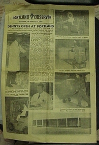
Newspaper, The Portland Observer
First page has article and photographs of new Dennys Lascelles Limited wool store in Portland.The Portland Observerwool stores, portland observer dennys, lascelles limited, portland, victoria -
Glenelg Shire Council Cultural Collection
Photograph - Photograph, framed collection - Early shipping history in Portland, Victoria, Early shipping history in Portland, n.d
UnknownFramed collection of photographs in brown timber frame, under glass. 1. Portland 1903; 2. Shipping at Ocean Pier; 3. Bullock teams in Julia Street; 4. Portland early 1900; 5. Portland early 1980s; 6. Fisherman's breakwater South East gale; 7. S.S. Stentor being loaded by lighters - wool; 8. Lifeboat practice early 20th century.Front: Portland 1903/ Shipping at Ocean Pier/ Bullock teams in Julia Street/ Portland early 1900/ Portland early 1980s/ Fisherman's breakwater South East gale/ S.S. Stentor being loaded by lighters - wool/ Lifeboat practice early 20th century. Back: (no inscriptions)