Showing 104 items
matching railway tunnel
-
 Eltham District Historical Society Inc
Photograph, Spring Excursion, Exploring the Upper Yarra, 22 October 1995, 22/10/1995
[article by Bettina Woodburn in EDHS Newsletter No. 105, November 1995:] EXPLORING THE UPPER YARRA - We enjoyed the Spring Excursion, this year "Exploring the Upper Yarra" - in spite of the constant rain and the countryside under the cloud cover, especially in the valleys, being mainly shiny shades of green. The occasional fields of buttercups, clumps of arum lilies and splendid rhododendron and other flowering bushes became very special. The Cobb and Co coach was warm and a cosy retreat as we zig-zagged on the highways and byways to glimpse the Yarra River, upstream and down, its secret places, and particularly the many bridges. Russell excelled as 'Poet Laureate', reading from Dacre Smyth's book. This 1979 publication includes paintings of all the bridges along the river with poems and brief descriptions of each one. Some of the bridges are in out-of-the-way places and are not very well known. We looked forward to hearing the poetry as much as seeing the 'constructions'… Big Pat (was he short or tall, lean or fat? - he did win the £200 reward for discovering gold and had the creek named after him), about the 'Eddies'?, and the disliked 'meccano' bridge in Warburton, etc. etc. The hot roast lunch in the old Reefton Hotel was also most welcome. It was easy to imagine it peopled by miners and early settlers. Starting by crossing the new (1974) concrete bridge at Warrandyte we headed through Wonga Park with views to the Christmas Hills and to the escarpment of the Yering Gorge, which causes flood waters to back up through the Yarra Glen plain, so avoiding disasters downstream. At the end of a long driveway we found the wooden, privately owned Henley Bridge (1935 after the 1934 floods). This facilitates access to different parts of Henley Farm and to Lilydale. Everard Park, named after Blanche Shallard's father, a State Member for 17 years, below the Highway Yarra crossing was in need of care. It is 10 miles from Yarra Glen by road but, as "Yarra Marra” canoeists well know, 32 winding miles down by water. After more delightful countryside scenes we joined the Warburton Highway at Woori Yallock. From the old Railway Station at Launching Place the Centennial Trail for walkers, cyclists and horse riders has replaced the rails. The line from Lilydale was opened in 1901, and the last diesel freight train ran to Warburton in 1965. It continued to rain as we had morning tea in Warburton in a shelter between footbridges. From here we continued upstream past the Bridge to O'Shannassy Lodge and Reservoir, Starvation Creek, and the Peninsular tunnel (miners dug it as at Pound Bend) which we visited (scrambling down those steps!) on our return after lunch. Our furthermost point was the Upper Yarra Dam Reserve (and vast catchment area). Finished in 1957 after ten years' work and 100 years after Yan Yean, it supplies much of Melbourne's water. After crossing the 30m Launching Place Bridge to the Eltham side of the Yarra and Healesville, we saw in the distance the Yarra Glen Timber Trestle Bridge over the river flats "the longest for years in the land it was said!" Harry's dream of "better weather over the Divide" unfortunately didn't come true, but I'm sure we 36 members will retain happy memories of a day that was wet and green and filled with Bridges.Two colour photographsactivities, upper yarra, upper yarra dam -
 Eltham District Historical Society Inc
Photograph, Yarra River from Henley Bridge, Kangaroo Ground, Spring Excursion, Exploring the Upper Yarra, 22 October 1995, 22/10/1995
[article by Bettina Woodburn in EDHS Newsletter No. 105, November 1995:] EXPLORING THE UPPER YARRA - We enjoyed the Spring Excursion, this year "Exploring the Upper Yarra" - in spite of the constant rain and the countryside under the cloud cover, especially in the valleys, being mainly shiny shades of green. The occasional fields of buttercups, clumps of arum lilies and splendid rhododendron and other flowering bushes became very special. The Cobb and Co coach was warm and a cosy retreat as we zig-zagged on the highways and byways to glimpse the Yarra River, upstream and down, its secret places, and particularly the many bridges. Russell excelled as 'Poet Laureate', reading from Dacre Smyth's book. This 1979 publication includes paintings of all the bridges along the river with poems and brief descriptions of each one. Some of the bridges are in out-of-the-way places and are not very well known. We looked forward to hearing the poetry as much as seeing the 'constructions'… Big Pat (was he short or tall, lean or fat? - he did win the £200 reward for discovering gold and had the creek named after him), about the 'Eddies'?, and the disliked 'meccano' bridge in Warburton, etc. etc. The hot roast lunch in the old Reefton Hotel was also most welcome. It was easy to imagine it peopled by miners and early settlers. Starting by crossing the new (1974) concrete bridge at Warrandyte we headed through Wonga Park with views to the Christmas Hills and to the escarpment of the Yering Gorge, which causes flood waters to back up through the Yarra Glen plain, so avoiding disasters downstream. At the end of a long driveway we found the wooden, privately owned Henley Bridge (1935 after the 1934 floods). This facilitates access to different parts of Henley Farm and to Lilydale. Everard Park, named after Blanche Shallard's father, a State Member for 17 years, below the Highway Yarra crossing was in need of care. It is 10 miles from Yarra Glen by road but, as "Yarra Marra” canoeists well know, 32 winding miles down by water. After more delightful countryside scenes we joined the Warburton Highway at Woori Yallock. From the old Railway Station at Launching Place the Centennial Trail for walkers, cyclists and horse riders has replaced the rails. The line from Lilydale was opened in 1901, and the last diesel freight train ran to Warburton in 1965. It continued to rain as we had morning tea in Warburton in a shelter between footbridges. From here we continued upstream past the Bridge to O'Shannassy Lodge and Reservoir, Starvation Creek, and the Peninsular tunnel (miners dug it as at Pound Bend) which we visited (scrambling down those steps!) on our return after lunch. Our furthermost point was the Upper Yarra Dam Reserve (and vast catchment area). Finished in 1957 after ten years' work and 100 years after Yan Yean, it supplies much of Melbourne's water. After crossing the 30m Launching Place Bridge to the Eltham side of the Yarra and Healesville, we saw in the distance the Yarra Glen Timber Trestle Bridge over the river flats "the longest for years in the land it was said!" Harry's dream of "better weather over the Divide" unfortunately didn't come true, but I'm sure we 36 members will retain happy memories of a day that was wet and green and filled with Bridges.Colour photographactivities, upper yarra, henley bridge -
 Ringwood and District Historical Society
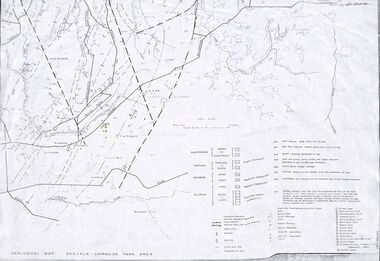
Map - Maps, Geological Map Donvale to Chirnside Park, also Victorian Railways Maps of Hawthorn to Lilydale Line incl Ringwood to East Ringwood - 1881
Faint photocopies of sections of larger maps. Geological map includes location of mine shafts circa 1920.Victory Shaft, North Victory Shaft, South Caledonia Shaft, Caledonia Shaft, North Caledonia Shaft, Black Swan Shaft, Reward Shaft, Consols Shaft, Blocks Shaft, Devonshire Shaft, Crown Shaft, Yarra Tunnel Reef Working, Bright's Shaft, Kingwood Antimony Company Shaft (Boardman's Shaft), Southern Shaft. -
 Eltham District Historical Society Inc
Photograph, Peter Bassett-Smith, Upper Yarra Dam, Spring Tour, 22 Oct 1995, 22/10/1995
EXPLORING THE UPPER YARRA (Newsletter No. 105, November 1995, by Bettina Woodburn) We enjoyed the Spring Excursion, this year "Exploring the Upper Yarra" - in spite of the constant rain and the countryside under the cloud cover, especially in the valleys, being mainly shiny shades of green. The occasional fields of buttercups, clumps of arum lilies and splendid rhododendron and other flowering bushes became very special. The Cobb and Co coach was warm and a cosy retreat as we zig-zagged on the highways and byways to glimpse the Yarra River, upstream and down, its secret places, and particularly the many bridges. Russell excelled as 'Poet Laureate', reading from Dacre Smyth's book. This 1979 publication includes paintings of all the bridges along the river with poems and brief descriptions of each one. Some of the bridges are in out of the way places and are not very well known. We looked forward to hearing the poetry as much as seeing the ' constructions'…Big Pat (was he short or tall, lean or fat? He did win the two hundred pound reward for discovering gold and had the creek named after him), about the 'Eddies'?, and the disliked 'meccano' bridge in Warburton, etc. etc. The hot roast lunch in the old Reefton Hotel was also most welcome. It was easy to imagine it peopled by miners and early settlers. Starting by crossing the new (1974) concrete bridge at Warrandyte we headed through Wonga Park with views to the Christmas Hills and to the escarpment of the Yering Gorge, which causes flood waters to back up through the Yarra Glen plain, so avoiding disasters downstream. At the end of a long driveway we found the wooden, privately owned Henley Bridge (1935 after the 1934 floods). This facilitates access to different parts of Henley Farm and to Lilydale. Everard Park, named after Blanche Shallard's father, a State Member for 17 years, below the Highway Yarra crossing was in need of care. It is 10 miles from Yarra Glen by road but, as "Yarra Marra” canoeists well know, 32 winding miles down by water. After more delightful countryside scenes we joined the Warburton Highway at Woori Yallock. From the old Railway Station at Launching Place the Centennial Trail for walkers, cyclists and ' horse riders has replaced the rails. The line from Lilydale was opened in 1901, and the last diesel freight train ran to Warburton in 1965. It continued to rain as we had morning tea in Warburton in a shelter between footbridges. From here we continued upstream past the Bridge to O'Shannasy Lodge and Reservoir, Starvation Creek, and the Peninsular tunnel (miners dug it as at Pound Bend) which we visited (scrambling down those steps!) on our return after lunch. Our furthermost point was the Upper Yarra Dam Reserve (and vast catchment area). Finished in 1957 after ten years work and 100 years after Yan Yean, it supplies much of Melbourne's water. After crossing the 30m Launching Place Bridge to the Eltham side of the Yarra and Healesville, we saw in the distance the Yarra Glen Timber Trestle Bridge over the river flats "the longest for years in the land it was said!" Harry's dream of "better weather over the Divide" unfortunately didn't come true, but I'm sure we 36 members will retain happy memories of a day that was wet and green and filled with Bridges. Bettina Woodburn - October 1995 Record of the Society's history of activities - Spring 1995 excursionColour photographactivities, upper yarra dam, 1995, peter bassett-smith -
 Eltham District Historical Society Inc
Photograph, Peter Bassett-Smith, Upper Yarra Dam, Spring Tour, 22 Oct 1995, 22/10/1995
EXPLORING THE UPPER YARRA (Newsletter No. 105, November 1995, by Bettina Woodburn) We enjoyed the Spring Excursion, this year "Exploring the Upper Yarra" - in spite of the constant rain and the countryside under the cloud cover, especially in the valleys, being mainly shiny shades of green. The occasional fields of buttercups, clumps of arum lilies and splendid rhododendron and other flowering bushes became very special. The Cobb and Co coach was warm and a cosy retreat as we zig-zagged on the highways and byways to glimpse the Yarra River, upstream and down, its secret places, and particularly the many bridges. Russell excelled as 'Poet Laureate', reading from Dacre Smyth's book. This 1979 publication includes paintings of all the bridges along the river with poems and brief descriptions of each one. Some of the bridges are in out of the way places and are not very well known. We looked forward to hearing the poetry as much as seeing the ' constructions'…Big Pat (was he short or tall, lean or fat? He did win the two hundred pound reward for discovering gold and had the creek named after him), about the 'Eddies'?, and the disliked 'meccano' bridge in Warburton, etc. etc. The hot roast lunch in the old Reefton Hotel was also most welcome. It was easy to imagine it peopled by miners and early settlers. Starting by crossing the new (1974) concrete bridge at Warrandyte we headed through Wonga Park with views to the Christmas Hills and to the escarpment of the Yering Gorge, which causes flood waters to back up through the Yarra Glen plain, so avoiding disasters downstream. At the end of a long driveway we found the wooden, privately owned Henley Bridge (1935 after the 1934 floods). This facilitates access to different parts of Henley Farm and to Lilydale. Everard Park, named after Blanche Shallard's father, a State Member for 17 years, below the Highway Yarra crossing was in need of care. It is 10 miles from Yarra Glen by road but, as "Yarra Marra” canoeists well know, 32 winding miles down by water. After more delightful countryside scenes we joined the Warburton Highway at Woori Yallock. From the old Railway Station at Launching Place the Centennial Trail for walkers, cyclists and ' horse riders has replaced the rails. The line from Lilydale was opened in 1901, and the last diesel freight train ran to Warburton in 1965. It continued to rain as we had morning tea in Warburton in a shelter between footbridges. From here we continued upstream past the Bridge to O'Shannasy Lodge and Reservoir, Starvation Creek, and the Peninsular tunnel (miners dug it as at Pound Bend) which we visited (scrambling down those steps!) on our return after lunch. Our furthermost point was the Upper Yarra Dam Reserve (and vast catchment area). Finished in 1957 after ten years work and 100 years after Yan Yean, it supplies much of Melbourne's water. After crossing the 30m Launching Place Bridge to the Eltham side of the Yarra and Healesville, we saw in the distance the Yarra Glen Timber Trestle Bridge over the river flats "the longest for years in the land it was said!" Harry's dream of "better weather over the Divide" unfortunately didn't come true, but I'm sure we 36 members will retain happy memories of a day that was wet and green and filled with Bridges. Bettina Woodburn - October 1995 Record of the Society's history of activities - Spring 1995 excursionColour photographactivities, upper yarra dam, 1995 -
 Glen Eira Historical Society
Album - Album page, Hotham Street, Circa 1972
... brick bay windows verandahs railway bridges tunnels gardens ...This photograph is part of the Caulfield Historical Album 1972. This album was created in approximately 1972 as part of a project by the Caulfield Historical Society to assist in identifying buildings worthy of preservation. The album is related to a Survey the Caulfield Historical Society developed in collaboration with the National Trust of Australia (Victoria) and Caulfield City Council to identify historic buildings within the City of Caulfield that warranted the protection of a National Trust Classification. Principal photographer thought to be Trevor Hart, member of Caulfield Historical Society. Most photographs were taken between 1966-1972 with a small number of photographs being older and from unknown sources. All photographs are black and white except where stated, with 386 photographs over 198 pages.Victorian Heritage Database - Hotham Street Road Overbridge HO116 Heritage Overlay - City of Glen Eira https://vhd.heritagecouncil.vic.gov.au/places/43557 (as of 04/07/2021) The Hotham Street road overbridge is located on the Sandringham railway line between Ripponlea and Elsternwick railway stations. It is presumed to have been built by contractors Sharp and Campbell who signed a contract on 25th . November, 1881 to construct a second line of railway between Windsor and Elsternwick. This contract was completed during 1882 and the bridge may have been designed in the year when Robert Watson took over from William Elsdon as engineer in chief for the Victorian railways. It is historically, aesthetically and technically significant. It is historically significant (Criterion A) to the extent that it demonstrates the standards of construction adopted by the Victorian Railways Department when it rebuilt the lines acquired from the private railway companies, (compare the Geelong and Melbourne Railway Co's line from Newport to Geelong, acquired in 1860). It is aesthetically significant (Criterion E) as an intact nineteenth century structure of its type, many similar girder bridges having been renewed with concrete girders in recent years. The bluestone abutments demonstrate high standards of stone masonry and are representative of Departmental work of the period. This bridge forms one of a group of historic structures on the railway to Brighton Beach and therefore contributes to the line's cultural importance as a whole. The survival of the riveted iron girders with their bellied angle iron struts is important since these elements are representative of the civil engineering practices of the Victorian Railways at the time and constitute the technical significance (Criterion F) of the structure.Page 96 of Photograph Album with three photographs (one portrait and two landscape) from Hotham Street - two external views of one house and a railway bridge.Handwritten: Hotham Street [top right] / 112 HOTHAM ST [under top left photo] / BRIDGE OVER SANDRINGHAM RAILWAY [under top right photo] / 112 HOTHAM ST CNR MELBY AVE [under bottom left photo] / 96 [bottom right]trevor hart, elsternwick, hotham street, caulfield, houses, brick, bay windows, verandahs, railway bridges, tunnels, gardens, bluestone, civil engineering, victorian railways, sharp and campbell, contractors -
 Federation University Historical Collection
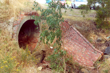
Photograph - Photograph Colour, Clare Gervasoni, Former Ballarat - Buninyong Railway Line Barrel Culvert, 1995, 2005
... a circular tunnel. Former Ballarat - Buninyong Railway Line Barrel ....1 shows part of a the track still on locationSixteen colour photographs of a brick culvert built as part of the Ballarat - Buninyong Railway Line taken in 1995. The culvert is in disrepair and is located at Mt Helen. The culvert has bricks throughout it and creates a circular tunnel.railway, brick, train, culvert, barrel culvert -
 Federation University Historical Collection
Photograph - Photograph - Colour, Caroline Winter, World War One Graves, 05/08/2012
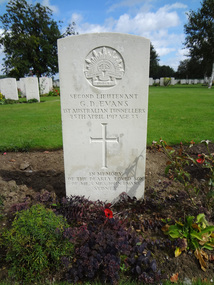
These photographs were taken by Caroline Winter, lecturer at the University of Ballarat. Horace Pickford was born at Clunes, Victoria. He was killed in action on 27 September 1917. According to his dossier Pickford was in the 58th battalion and was buried in the vicinity of Polygon Wood. Glyndwr Evans was a native of Treorchy in the Welsh Rhondda Valley. He emigrated to Australia with his parents who lived at Randwick in New South Wales. He attended the Ballarat School of Mines, and served on the Student's Magazine Committee in 1905. The following year Glyndwr took up a position as a solutionist at the Golden Horseshoe Mine at Kalgoorlie. In the application for a commission in the AIF Glyndwr stated at he had completed three years at the Ballarat School of Mines, obtaining a Mine Manager's Certificate of Competancy, an Assayers Certificate and additional certificates in Land Surveying, Electrical Technology, Metallurgy and Geology. Gyndwr was a member of the AIF 1st Australian Tunnelling Coy. He was killed in Action at Hill 60 on 25 April 1917 and is buried in Belgium at the Railway Dugout Burial Ground (Plot VII, Row G, Grave 33). (http://guerin.ballarat.edu.au/aasp/is/library/collections/art_history/honour-roll/honourroll_Evans.shtml) A number of colour photographs of World War One war graves of soldiers from the Ballarat district. .1) Horace Pickford's headstone, Tyne Cot Cemetery .2) Glyn Evans tombstone, Railway Dugouts Cemetery south of Ypres. 3. Railway Dugouts Cemetery, Glyn Evans tombstone has a poppy on it. university of ballarat, world war one, war graves, war cemetery, world war i, world war, pickford, evans, horace pickford, harry pickford -
 Federation University Historical Collection
Book, Railway Practice: a collection of working plans and practical details of construction in the public works of the most celebrated engineers, 1847 (exact)
A green cloth hard cover book. Title and author's name are engraved in gold on spine. This is the 3rd edition, first series with black and white illustrations. It describes the engineering practices of the early days of British railroads. The book includes (series 1 to 4)and it contains, roads, tramroads and railroads, bridges, aqueducts, viaducts, wharfs, warehouses, roofs, and sheds, canals, locks, sluices, & the various works on rivers, streams, etc., harbours, docks, piers and jetties, tunnels, cuttings and embankments, the several works connected with the drainage of marshes, marine sands, and the irrigation of land, water-works, gas-works, water-wheels, mills, engines.civil engineering, railway practice, rail constructions, s c brees, western railway great britain, public works, railroads, canals, s.c. brees, samuel brees, samuel charles brees -
 Federation University Historical Collection
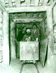
Photograph - Black and White, 1988, Three men standing behind a trolley in a mine tunnel, 06/1988
This image was taken at the conclusion of a special eight week "Crash course" in mining, requested by Eastern Reefs. It was used in the Ballarat School of Mines Review, 1988, page 7.Black and white image of three men standing behind a trolley in a mine tunnel showing supporting beams (thought to be Sovereign Hill) They are from left to right Ernie Terrill (Ballarat CES), Raymond Collins (Ballarat School of Mines Mining Student) and Malcolm Vallance (Ballarat School of Mines Special Projects Manager).ballarat school of mines, mines, mining, mining trolley, mine truck, mining railway, malcolm vallance, mal vallance, raymond collins, ernie terrill, eastern reefs, sovereign hill, mining education -
 Federation University Historical Collection
Book, Jacobs Lewis Vines Architects and Conservation Planners, Historic Sites Survey: Ballarat Study Area, 1980, 1980
This survey was commissioned by the Land Conservation Council, Australian Heritage Commission and the Ministry for Conservation 114 page report on historic sites in the Ballarat region. It includes information on sites, a schexdule of sites, silte selection and designated areas (ie around towns)historic sites, ballarat, wendy jacobs, miles lewis, gary vines, berringa, buninyong, creswick, dunnstown, fiery creek, lal lal, langi logan, cathcart, mount cole, mount egerton, nerrina, gong gong, wombat state forest, railways, explorers routes, early roads, land conservation council, ausralian hertiage commission, department of planning, icomos (burra) charter, nigel lewis, richard aitken, freehold land, public land, langi ghiran, new jubille mine, birthday tunnel mine, pitfield plains, smythesdale, buninyong company, mount clear, mt clear, canadian gully, warrenheip distillery, thomas mitchell, waterloo, trawalla, beaufort, raglan, internment camps, forestry, mining, mining, mt egerton, mary hollick collection, jubilee mine, burra charter, historica areas data form, explorers, egerton company, black horse mine, mt egerton government battery, kaolin mines, anderson brothers, barkstead, anderson's tramway, clarkesdale, berry leads, birthday tunnel mine berringa, warrenheip, australasian company, mount mercer, lanvi-kal-kal, water race -
 Bendigo Historical Society Inc.
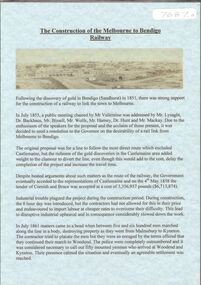
Document - RAILWAYS COLLECTION: THE BIG HILL TUNNEL
Railways Collection- Extract from page 78 &79 of Annals of Bendigo - Opening of the Bendigo railway - Black and white photo of The Big Hill Tunnel. The article describes the official Line opening ceremony.photograph, train -
 Bendigo Historical Society Inc.
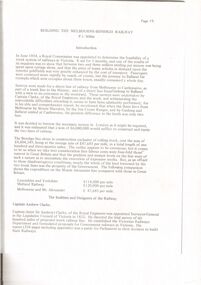
Document - ''THE CONSTRUCTION: OF THE MELBOURNE TO BENDIGO RAILWAY'' P.1
''The Construction of the Melbourne to Bendigo Railway' pages 1 and 2 (separate sheets) of a document (laminated) prepared by the Bendigo Historical Society and outlining the history of the construction of the line..Bendigo Historical Societybendigo, history, bendigo railway, construction of the melbourne to bendigo rail line. mr valintine, mr lysaght, dr backhaus, mr bissell, mr harney, dr hunt , mr mackay, cornish & bruce, malmsbury viaduct, taradale viaduct, coliban river, elphinstone tunnel, big hill tunnel, sir henry barkly, mr robert burrowes. -
 Bendigo Historical Society Inc.
Document - BUILDING THE MELBOURNE TO BENDIGO RAILWAY
'BUILDING THE MELBOURNE-BENDIGO RAILWAY'' ( P J MILLAR). Copied from ??? With pages numbered from 19 to 42. Detailed coverage under sections: The builders and designers of the Railway; Some of the bridges along the line (viaducts and tunnels); Ordering of materials and plant; Transport of material; The strikes along the line; Riots on the line; Darbyshire's resignation; Conclusion. Includes 12 figures (poor quality reproduction photos and one map (Contracts for the Main Trunk Lines). One copy without stapling; oneP. J. Millarbendigo, history, bendigo railway, bendigo railway, j. p. millar, captain andrew clarke. -
 Bendigo Historical Society Inc.
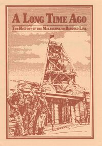
Document - A LONG TIME AGO: THE HISTORY OF THE MELBOURNE TO BENDIGO LINE
'A LONG TIME AGO: THE HISTORY OF THE MELBOURNE TO BENDIGO LINE' Bi-fold publication. A schematic 'strip' map of the line with particular places (approx 40) marked on the route with short descriptions of these sites. Concise description of the construction of the line; a summary of present attractions for the visitor to Bendigo and V/Line information.Walker Printing Bendigorailways, bendigo to melbourne, brochure, barkers creek , harcourt, elphinstone tunnel, malsmbury, malmsbury viaduct, kyneton, carlsruhe, hanging rock, woodend, mount macedon, riddells creek, clarkefield hotel, rupertswood, sunbury, diggers rest, sydenham, st albans, spencer street. v/line. -
 Bendigo Historical Society Inc.
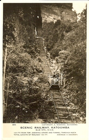
Photograph - BASIL MILLER COLLECTION: SCENIC RAILWAY - KATOOMBA N.S.W
Two black and white photographs of the scenic railway located at Katoomba N.S.W. Inscriptions: Number 503 on front of one and 496 on other. They both have the same inscriptions on front; Copyright. A. Manning Katoomba, Scenic Railway Katoomba, Blue Mountains N.S.W. Grade at this point52 degrees for a distance of 181 feet (503). 1200 feet from the top showing grade and tunnel through rock (496). Total length of railway 1300 feet at an average gradient of 45 degrees.person, individual, basil miller -
 Bendigo Historical Society Inc.
Photograph - VIEWS OF BENDIGO: COPIES OF 52 PHOTOS, 1850 - 1900
Copies of Photographs from - Views of Bendigo by Nicholas Caire Originals in Box 13 No.1 Sandhurst east/ City Reserve x 2 No 2 New Chum Line of Reef No 3 Sandhurst to North from top of Masonic Hall No.4 Hustler's Line of Reef No.5 Battery of stampers for crushing quartz x 2 No.6 View Sandhurst from top of Masonic Hall x 2 No.7 Excavation Quartz Reef, Ironbark Hill. No 8 St. Paul's Church. No.9 View Camp Reserve from Court House. No.10 View of Nth. Old Chum. No.11 View Camp Hill near the Lodge x 2 No.12 Garden Gully. No.13 Shamrock Hotel, Sandhurst. No.14 View from Court House, east end Pall Mall. No.15 Wesleyan Church, Golden Square x 2 No.16 Savings Bank, Sandhurst No.17 Bendigo District Hospital. No.18 Interior Wesleyan Church x 2 No.19 View Golden Square township. No.20 The Town Hall, Sandhurst. No 21 The City Hotel,Sandhurst. No 22 Pall Mall Sandhurst, No 23 Sandhurst City Market No 24 Pall Mall looking west x 2 No 25 Camp Hill x 2 No 26 Charing Cross No 27 View Sandhurst. x 2 No 28 Long Gully. No 29 Railway station and sheds No 30 Cemetery Back Ck. No 31 Kock's Pioneer Quartz Crushing Plant Long Gully. No 32 Masonic Hall. No 33 Bendigo Benevolent Asylum. No 34 Bendigo Flat. No 35 Old Chum Hill x 2 No 36 New Chum Gully No 37 Township of Eaglehawk No 38 From St Paul's tower looking west No 39 Tunnel Big Hill. No 40 From St Paul's tower looking south x 2 No 41 From St Paul's tower looking eastward x 2 No 42 From St Paul's tower looking north west x 2 No 43 Great Extended Hustlers Quartz Mining Claim No 44 Big Hill Rail line x 2 No 45 From St Paul's tower looking westward x 2 No 46 From St Paul's tower looking north west No 47 Big Hill Ranges Buick. x 2 No 48 St.Paul's Tower x 2 No 49 Eaglehawk township. No 50 Mitchell Street No 51 Botanical gardens, White Hills x 2 No 52 View Point, Sandhurst. .N.J. Caire.place, bendigo, bendigo area., views of bendigo. -
 Bendigo Historical Society Inc.
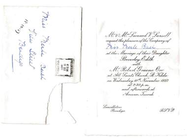
Document - BUSH COLLECTION: ITEMS OF CORRESPONDENCE (TO MISS M BUSH), a. 1937; b. 1964
Items of correspondence (to Miss M Bush). A. Invitation to Miss M Bush to marriage of Beverley Edith Lansell to Robert Graeme Orr on 10/11/1937. Postmarked 18/10/37; b. from Office of The Secretary for Railways (NSW) to M. Bush re enquiry about Reso train. Letter, receipts and two photographs of Reso train leaving Running Creek No 2 tunnel (North Coast Line).person, individual, bush collection - personal, bush collection, collection, wedding invitation, photograph, photo, correspondence, reso train, transportation, trains, railway line -
 Bendigo Historical Society Inc.
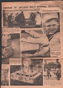
Newspaper - FOSTER AND WILSON COLLECTION: THE SUN NEWS-PICTORIAL, 22 September 1936
Pages 19, 20, 21 & 22 of the Sun News-Pictorial dated Tuesday, September 22, 1936. It has part of a serial, racing news and a number of pictures spread over pages 20 & 21. One of the pictures is a goods train emerging from the tunnel north of Elphinstone, on the Bendigo line. Another picture is a small child, Kelvin Rodgers who had been to America to have a nail removed from his lung.newspaper, sun news -pictorial, tunnerl scene bendigo railway, foster & wilson collection, the sun news-pictorial 22 sep 1936 -
 Bendigo Historical Society Inc.
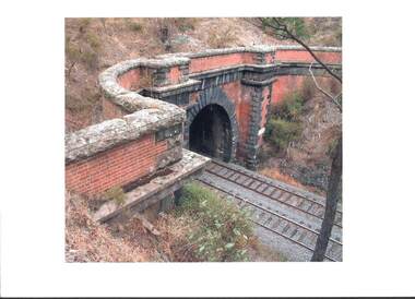
Photograph - RAILWAYS COLLECTION: COLOUR PHOTO OF ELPHINSTONE RAIL TUNNEL
RAILWAYS COLLECTION -Colour Photo of Elphinstone Tunnel (a similar photo was used by Jim Evans in his booklet -Melbourne to Bendigo Railway 1862-2012 and quotes the Photographer as Geoffrey Russell). The photo is printed on quality paper showing an entrance to the tunnel which is in fair condition with bricks and stone on the face and has two train tracks running through.Geoffrey Russellphotograph, landscape -
 Bendigo Historical Society Inc.
Photograph - RAILWAYS COLLECTION: COLOUR PHOTO OF ELPHINSTONE TUNNEL
RAILWAYS COLLECTION 2 x -Colour Photos of Elphinstone Tunnel (this photo was used by Jim Evans in his booklet -Melbourne to Bendigo Railway 1862-2012 and quotes the Photographer as Geoffrey Russell). The photo is printed on quality paper showing an entrance to the tunnel which is in fair condition with bricks and stone on the face and has two train tracks running through.Geoffrey Russellphotograph, landscape, elphinstone tunnel long rail laid bendigo, wednesday.—one of the most unusual operations undertaken by the victorian railways took place on the bendigo-melbourne line at the elphinstone tunnel this afternoon, when two rails, each 1, 710ft. in length, were placed in posi- tion in the tunnel. these rails were the longest ever laid in victoria, the previous greatest length being 225ft. the tunnel, which is 1, 254ft. in length, is the longest in the state, and forms an historic link with the early railways of victoria, being constructed in 1862, three years after the first train ran in australia. the object of the work is to improve the track for the fast train services and to reduce the cost of maintenance. by putting in a welded rail right through the tunnel the use of "fish plates" will be eliminated. for the new undertaking 110lb. rails are being used to replace the 80lb. rails at present in use. the rails, each weighing 30 tons, were made from 38 sets of rails of 45ft. each, the welding taking place on the site of the work. hauled by an x35 locomotive the long rail was placed in position 3½ minutes after the first pull. the work was carried out without any in- terruption to traffic. -
 Coal Creek Community Park & Museum
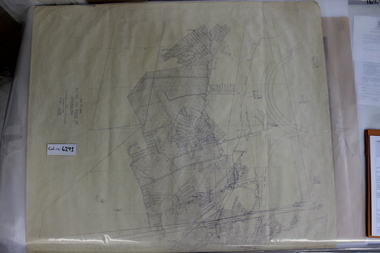
Mine Map, 1942
6291.1 - Plan of "Austral Coal Mining Co" Lease in Korumburra detailing the mine tunnel plan, coal seam areas and some surface features such as railway sidings & Leura Creek. -
 Bendigo Historical Society Inc.
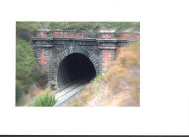
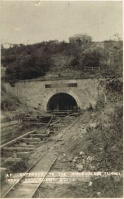
Postcard - ACC LOCK COLLECTION: ENTRANCE TO THE HINDENBERG TUNNEL NEAR BELLICOURT - POSTCARD, 1914-1918
... Tunnel near Bellicourt. Damaged railway lines in front... POSTCARD Postcard WW1 Hindenberg Tunnel Bellicourt Postcard, WW1, B ...Postcard, WW1, B&W image of the entrance to the Hindenberg Tunnel near Bellicourt. Damaged railway lines in front . A building above the tunnel. Five figures standing at the entrance. Two copies A7postcard, postcard, ww1, hindenberg tunnel, bellicourt -
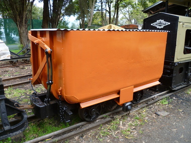 Puffing Billy Railway
Side Tipping Wagon - W. G. Allen & Sons (Tipton) Ltd
Built by W. G. Allen & Sons (Tipton) Ltd., Tipton, Staffordshire, England. This vehicle was used on the construction of dams, etc., and the Jindivick tunnel at Tarago in Gippsland for the state Rivers & Water Supply Commission of Victoria. The small wheel located on the side ran up a suitably located ramp automatically tipping the hopper and emptying the contents. Historic - Industrial Narrow Gauge Railway - side tipping wagon used by the State Rivers & Water Supply Commission of Victoria - Jindivick tunnel at Tarago, Victoria, AustraliaSide Tipping Wagon made of Iron, steel and wrought ironpuffing billy railway, pbr, side tipping wagon - w. g. allen & sons (tipton) ltd, puffing billy, side tipping wagon, w. g. allen & sons (tipton) ltd, jindivick tunnel, state rivers & water supply commission of victoria -
Whitehorse Historical Society Inc.
Article, Crossing work starts, 2003
Article on grade separation at Middleborough Road railway crossing; with items on maintaining tunnel design in proposed Mitcham Frankston Freeway.Article on grade separation at Middleborough Road railway crossing; with items on maintaining tunnel design in proposed Mitcham Frankston Freeway.Article on grade separation at Middleborough Road railway crossing; with items on maintaining tunnel design in proposed Mitcham Frankston Freeway.eastern freeway extension, railway crossings, middleborough road, blackburn, laburnum railway station -
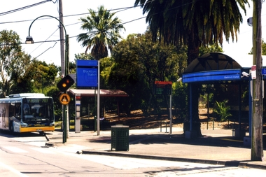 Whitehorse Historical Society Inc.
Photograph, Blackburn Railway Station, 2012
Coloured photograph of the entrance to the Blackburn Railway Station in South Parade , Blackburn. A ventura bus is on the left and the entrance to the underground tunnel is on the right - 2012blackburn railway station, south parade blackburn, transport -
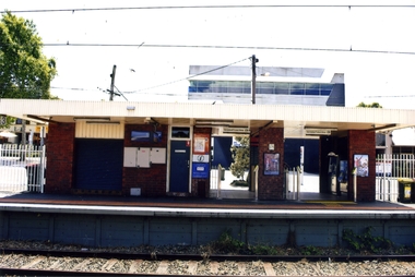 Whitehorse Historical Society Inc.
Photograph, Blackburn Railway Station, 2012
... and South Parade via a tunnel - 2012 Blackburn Railway Station ...See NP3406Coloured photograph of the railway line near the Blackburn station, heading west towards the 'city Entry is from Railway Road and South Parade via a tunnel - 2012blackburn railway station, railways