Showing 120 items
matching rural view
-
 Greensborough Historical Society
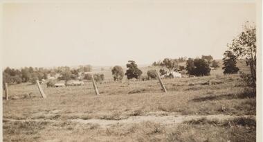
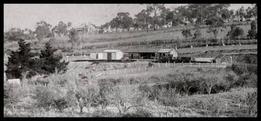
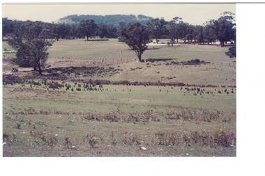
Photograph - Digital image, View from Rose McLaughlin's house, Beales Road Greensborough 1937, 1937_
Part of a collection of photographs copied from the late Shirley Fraser (nee Black), also descendant of the McLaughlin and Whatmough family. This photograph shows the view from Rose McLaughlin's Beales Road home in 1937.This photograph shows the rural nature of Greensborough in the 1930s.Digital copy of black and white photograph.shirley fraser, rosalie mclaughlin, beales road -
 Greensborough Historical Society
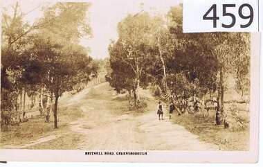
Postcard, The Rose Stereographs, Britnell Road, Greensborough, 1920s
This postcard shows us what Britnells Road (now Mountainview Road) looked like in the WW1 era. Britnell Road is a former name of the Mountain View Road section between St Helena Rd and Sherbourne Rodd.A sepia toned postcard featuring a photograph of a rural road scene.2 photo mount remains on rear, nil on front.britnell road, greensborough, mountain view road. -
 Greensborough Historical Society
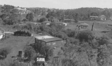
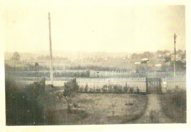
Photograph - Digital image, View of Bicton Street from Gladstone Road, 1950_
This view of Bicton Street Greensborough, taken from Gladstone Road Briar Hill circa 1950 shows the rural nature of the suburb at this time.Digital copy of black and white photo.bicton street greensborough, gladstone road briar hill -
 Greensborough Historical Society
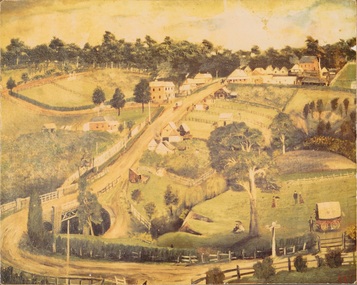
Print, Greensborough 1889 / Arthur Elliott, 1889_
... Park and bluestone bridge in foreground. A view of rural ...Mounted print of "Greensborough 1889 painted by Arthur Elliott". Shows Main Street Greensborough with the Methodist Church in upper right corner, Lower Park and bluestone bridge in foreground.A view of rural Greensborough 1889.Print of painting, mounted on masonite.main street greensborough, arthur elliott -
 Greensborough Historical Society
Photograph - Digital image, Greensborough Station, 1923c
An early view of Greensborough Station showing the rural nature of the area in the early part of the 20th century.Digital copy of black and white photograph.greensborough station -
 Greensborough Historical Society
Photograph, Greensborough from the Godwill home, 1935c
... in Williams Street Greensborough. It shows a rural view of the area ...This was taken by Gordon Godwill in the mid 1930s.The photograph was taken from the Godwill home in Williams Street Greensborough. It shows a rural view of the area where the Greensborough Plaza now stands.A black and white photograph.Nilgodwill, williams st, greensborough plaza, 1930's -
 Glenelg Shire Council Cultural Collection
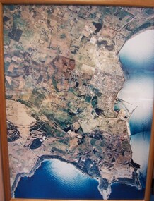
Photograph - Photograph - aerial view of Portland, 1988
Census Project No. 1995. Portland Dec. 1988.Aerial view of the "City of Portland" and surrounding rural area to a scale of 1:10,000 Aerial Photomosaic of Portland Bay, 1988Front: (no inscriptions) Back: (no inscriptions)aerial photography, central portland, portland harbour -
 Glenelg Shire Council Cultural Collection
Slide - Slide - Cashmore Airport, Portland, 1980s
... construction site Cashmore Airport engineering landscape rural Coloured ...Coloured slide. View of worksite, body of water in foreground; Earth moving equipment further back, then cattle and low hills at rear.portland airport, construction site, cashmore airport, engineering, landscape, rural -
Glenelg Shire Council Cultural Collection
Photograph - Photograph - Rural scene with gums and water, horse standing near tree, n.d
Black and white photo mounted on heavy card. Rural scene with gums and water, horse standing near tree.Back: 'View near Portland' - black pen -
Glenelg Shire Council Cultural Collection
Photograph - Photograph - Rural scene, n.d
Black and white photo mounted on heavy dark grey card. Image shows a rural scene, stream, reeds, bare trees of an unknown location.Back: 'View near Portland' - black pen. 'largo/fargo class 1 (all crossed out, black pen) -
Glenelg Shire Council Cultural Collection
Photograph - Photograph - Rural scene, n.d
Black and white photo mounted on dark grey card, with lighter border around print. Rural scene, waterway, derelict fence, gums, reeds.Back: 'View near Portland' largo/fargo class 1 - pen -
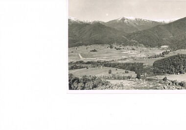
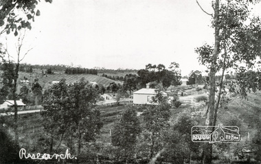
 Eltham District Historical Society Inc
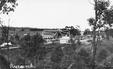
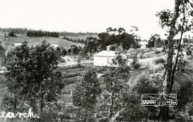
Negative - Photograph, Tom Prior, View of Research, Vic, c.1900
View of Research looking down Ingrams Road towards the rear of Doney's store, Main Road left to right. General Store centre. Ingrams Road opposite General Store. Hotel right of centre. The small building at left of photo housed the school for a short period of time but it was too hot in summer and the community lobbied for a more substantial school.This photo forms part of a collection of photographs gathered by the Shire of Eltham for their centenary project book,"Pioneers and Painters: 100 years of the Shire of Eltham" by Alan Marshall (1971). The collection of over 500 images is held in partnership between Eltham District Historical Society and Yarra Plenty Regional Library (Eltham Library) and is now formally known as the 'The Shire of Eltham Pioneers Photograph Collection.' It is significant in being the first community sourced collection representing the places and people of the Shire's first one hundred years. The Reynolds family were early settlers in Research. The Reynolds/ Prior collection of photographs were taken by Tom Prior, the maternal uncle of Ivy Reynolds, around 1900 and the 60 photos in the album give a fine overview of many of the landmarks of Research and Eltham over 100 years ago. lvy lived in the family home for many years at 106 Thompson Cres Research. Ivy's father, Ernst Richard Reynolds and grandfather, Richard Reynolds, lived at the same address. Ivy's father Richard worked for Mr. Trail on his property in Research. Reynolds Road is named after the family. Mr Tom Prior (wife Eva) worked at the Melbourne zoo. He was very innovative and made his own camera, using the black cloth hood to exclude the light. The photographs are a reminder of the rural nature of Research and Eltham and its rich heritage.Digital image 120 format B&W negativesepp, shire of eltham pioneers photograph collection, research (vic.), general store, ingrams road, main road, research hotel, doney property, research primary school, reynolds prior collection -
 Kiewa Valley Historical Society
Photograph Farm Land, Mount Beauty Acreage before Golf Course, Circa 1950
This photograph is a "snap shot" in time circa 1950s detailing the rural environment before the effects of the Kiewa Valley Hydro Scheme altered the basic rural setting of the valley. The golfing fairway was being mapped out on previous grazing land, before the laying of a golf course, for use by the construction workers and auxiliary administration employees of the Victorian State Electricity Commission. This photograph details a dramatic period in time which saw an enormous change to the exclusively rural area of the Kiewa Valley region in the mid 1900s. This change presented both physical and mental challenges to the existing quiet rural inhabitants of the valley. The State of Victoria had to make adjustments to the changing demands imposed by population and industrial expansions. The development of cleaner energy supplies to a growing population has its downside ,which ever way the intrusion into the "natural" landscape is made.Black and white photograph detailing surveyor posts for construction of golf course. Land used, before establishment of the Mount Beauty Village, as farming/grazing cattle and viewed towards Mount Bogong and its Alpine ranges. The photo is on 200gms paper and not on photographic paper.nilmount beauty in the 1940s - 1950s, grazing in the kiewa valley, sec victoria -
 Kiewa Valley Historical Society
Photograph Transmission lines Mount Beauty, 66 KVA Transmission lines from Clover Power Station, Circa 1950
This photograph is a "snap shot" in time circa 1950s detailing the rural environmental change and the progressive effects of the Kiewa Valley Hydro Scheme on the basic rural setting of the valley (note the sparsity of rural infrastructure). This photograph shows the beginning of the accommodation and administration buildings for use by the construction workers and auxiliary administration employees of the Victorian State Electricity Commission. It also provides a view of the landscape before extensive development of Pondage and other non rural buildings.This photograph details a dramatic period in time which saw an enormous change to the exclusively rural area of the Kiewa Valley region in the mid 1900s (see sparse rural buildings/houses). This change presented both physical and mental challenges to the existing quiet rural inhabitants of the valley. The State of Victoria had to make adjustments to the changing demands imposed by population and industrial expansions. The development of cleaner energy supplies to a growing population has its downside ,which ever way the intrusion into the "natural" landscape is made. The construction of the large Pondage at the centre of the photograph is a good example.This black and white photograph of a panoramic view of the Kiewa Valley (Mount Beauty SEC construction workers village) shows the newly completed transmission line towers delivering electrical power(66KVA) from the Clover Power Station. The photo is on 200gms paper and not on special photographic paper.mount beauty 1940 to 1950s, development of sec kiewa hydro scheme, sec victoria -
 Kiewa Valley Historical Society
Photograph of Kiewa Valley Panorama, Farming lands within the Kiewa Valley in1950s, Circa 1950
This photograph shows how (early to mid1900s), before the establishment of the Mount Beauty "gated" village, the Kiewa Valley was farmed and the scarce population was spread out over acres of productive land. This photograph catches a time before (what appeared to the local farmers as the invasion by a mass of construction workers) when this remote valley was part of a "lay back" rural landscape,occasionally visited by friends and some wayward tourists. The mountain ranges provided an adequate barrier against the way-would traveller. The immigration numbers coming into Australia was still quite small ( due to the "white" Australia policy) which was in force before World War II. After World War II a mass of displaced European refugees and migrants boosted the Australian population and provided for a greater degree of diverse professions and rural related work force.This photograph depicts the borderline in time between an exclusively rural based population and respective activities(early 1900s)to the present (2000 on wards) integrated village, tourist and retiree/holiday area. The time when land was exclusively used in agriculture is over and the impact of cheaper rural produce from Asian markets will see a shift of land useage and population activities. The Kiewa Valley is loosing its hiding place and is becoming more and more a source of untapped residential land. Black and white photograph of farming/grazing land useage, before the establishment of the Mount Beauty Village. Small pockets of residentual houses can be viewed. Road access (unsealed dirt) was typical of that provided in rural regions in the 1950s. The photo is on 200gms paper and not on photographic paper.kiewa valley in the early1900s, grazing in the kiewa valley, sec victoria -
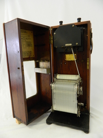 Kiewa Valley Historical Society
Meter Ammeter Recorder, Circa 1950
This testing voltmeter recorder was last certified by SEC Vic laboratories on the 17/4/77. It was used extensively as mobile recorder placed for periods of one month at locations experiencing unacceptable fluctuations of power. These locations would cover the North East regions of Victoria. They cover voltage drops at domestic and business properties especially those that were experiencing regular fluctuations(daily) at approximately the same time of the day. As the electrical network is required to operate within a set level of voltage, fluctuations outside of this has to be investigated and necessary remedial action taken. This is especially so for rural properties where power "drainage" can occur through animal/bird and tree interference. It can also be the result of defective wiring and overloading at peek operational times (milking machines).This mobile voltage recorder is very significant to the Kiewa Valley because it highlights the difficulties that can occur in maintaining a power supply that experiences fluctuating power demands by the rural industries that it supplies. The requirement of a mobile testing apparatus to cover the various sections in the Kiewa Valley and other rural areas in the northeast region is one of necessity as electricity once connected to a rural property is a labour saving supply as generators on rural properties require a higher degree of maintenance an ultimately at a higher cost. The testing of the SEC Vic supplied electricity to rural properties,those who had previously run on generators, had to be quick and unassuming with certainty of correct supply levels.The mechanism of this voltage recorder has been installed(by the manufacturer) into its own protective wooden box. This box has a front (swing open) lockable section which permits direct access to the installed measuring equipment (for servicing and data collection). The top section of the box has two screw on terminals for access to the machine being tested. This tester has its own inbuilt ink supply facilities and a mechanical clockwork device that unwinds a roll of paper onto a second roll at a rate of 10 mm per hour. The recording chart is marked with time slots against voltage. There is a recording arm which has an ink pen at the end. Both arm and pen carry the ink supply from the ink reservoir, located on the left side of the cabinet door in specially constructed bottle holder( three small bottle capacity). To record a suspect power problem to a home or business establishment the voltmeter is connected to a power supply outlet being tested and wind the recording clockwork mechanism (gives a four week running time). Before leaving the recorder in situ the electrician checks to see if the chart is recording the correct voltage and that the clock mechanism is advancing correctly.On the front of the access "door" at the top a metal label "RECORDING AMMETER" below this "MURDAY SYSTEM" below this "ALTERNATING CURRENT" and below this the manufacturer's registered number "No. 139156" Below this is a metal tag with State Electricity Commission of Victoria Electrical Engineer's Section equipment number "338" Below these tags and above the viewing window is the manufacturer's dtails "EVERSHED & VIGNOLES Led LONDON"sec vic kiewa hydro scheme, alternate energy supplies, alpine feasibility studies temperature, rainfall, power outages -
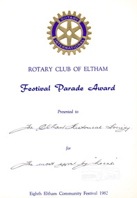 Eltham District Historical Society Inc
Certificate, Rotary Club of Eltham, Certificate, Festival Parade Award, Rotary Club of Eltham, Eighth Eltham Community Festival 1982, 1982
Eltham Community Festival awards. Awarded to the Shire of Eltham Historical Society for the most effort by locals. Newsletter No. 27, November 1982 ELTHAM COMMUNITY FESTIVAL Although our parade entry did not win a prize this year, it was considered highly successful from a participation point of view. Despite some uncertainty as to just who was corning, members and friends kept appearing at the assembly area . As in the past years our friends from the Victorian Folk Music·Club brought their instruments along and really added to the occasion. This year we concentrated on a rural theme with a tractor/trailer combination. Thanks to Peter Bassett-Smith for the tractor, Joh Ebeli for the decorations and friendly trailer owner Dennis McKay. Unfortunately the closing stages of the parade were marred by heavy rain. We just finished as the rain started but members scattered very quickly. This has prompted the suggestion for future parades that we have a tent or other suitable venue for members to gather after the event. This is worth following up. The cold driving rain provided a special problem for Peter in driving his tractor home to Kangaroo Ground. Have you ever had to choose between standing up to warm your hands on the exhaust and having your tractor seat flooded? Paper certificate printed with handwritten award nomination and categoryawards, eltham festival, rotary club of eltham, shire of eltham historical society, joh ebeli, peter bassett-smith -
 Eltham District Historical Society Inc
Photograph, Tom Prior, View looking down Ingrams Road, Research towards the rear of Doney's store
The small building at left of photo housed the school for a short period of time but it was too hot in summer and the community lobbied for a more substantial school.The Reynolds family were early settlers in Research. The Reynolds/ Prior collection of photographs were taken by Tom Prior, the maternal uncle of Ivy Reynolds, around 1900 and the 60 photos in the album give a fine overview of many of the landmarks of Research and Eltham over 100 years ago. lvy lived in the family home for many years at 106 Thompson Cres Research. Ivy's father, Ernst Richard Reynolds and grandfather, Richard Reynolds, lived at the same address. Ivy's father Richard worked for Mr. Trail on his property in Research. Reynolds Road is named after the family. Mr Tom Prior (wife Eva) worked at the Melbourne zoo. He was very innovative and made his own camera, using the black cloth hood to exclude the light. The photographs are a reminder of the rural nature of Research and Eltham and its rich heritage. Black and white photograph mounted in an album, the Reynolds/Prior Photograph Collection, this being one of 53 reproduced black and white images of early Eltham.The Reynolds/Prior Photograph Collection, Presented to the Eltham District Historical Society, 14 June 2006 by Ross McDonald. A second copy was also presented to the Andrew Ross Museum, Kangaroo Grounddoney property, general store, ingrams road, main road, research (vic.), research hotel, research primary school, reynolds prior collection, sepp, shire of eltham pioneers photograph collection -
 Kiewa Valley Historical Society
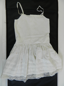
Petticoat Child
This petticoat is demonstrative of home made infant undergarment clothing in the early 1900. Distance to and from commercial haberdashery store was too far to fit out young girls especially if the are undergarments. Mothers and other family members had the seamstress talent to make clothes that are not in full view of anyoneHistorically these undergarments have no fashion relevance for the younger fashion scene and this garment is an example of the self sufficient supply of home made articles. This was especially so within the Kiewa Valley and surrounds. Fashion in Australia and more so in areas with little or no access to overseas or city merchandise lacked "modern fashionable" clothes e.g. the latest from England and Paris. This region was and still is a rural backdrop of clothes that fit into the type of life and work of the society it holds.Cotton petticoat, white, three buttons on top back, 8mm wide straps of cotton tape. Gathered skirt with triple row of Rick Rack on the bottom edge and three pintucks, 17mm wide, on the lower edge of skirt. Garment is completely hand stitchedchildren's underwear, female underwear, dressmaking, handcraft, costume, clothing -
 Kiewa Valley Historical Society
Book - Non Fiction History, The Kiewa Story, circa 1993
This book provides in chronological order the development of the Kiewa Hydro-electricity scheme from the first concept (1911) to final construction work (1961). It covers the first attempt to utilise the power of the Victorian Alps water system. It started from a private syndicate and developed to the current State Electricity Commission of Victoria. The incentive for the Hydro scheme was to make money and not as an alternative to the carbon producing coal fired power plants. These coal fired power plants were increasing in numbers to service an ever increasing demand made by population expansion, especially in cities and large rural settlements. This demand spiraled up after World War II when there was a tremendous spike in immigration numbers due to refugees and displaced persons in Europe. The ability to utilise the untapped water provided by the winter snow fields, for a higher yield in electricity, was a powerful incentive to overcome the physical hardships in this remote Alpine region. Future power requirements may initiate the re-installation of the other two power stations(Pretty Valley and Big Hill) covered in original Scheme. This publication not only covers the development of the Kiewa Valley region with respect to population (within a socio-economical framework) but also the subtle but yet strong physical changes of a relatively pristine alpine region. The demands that an ever growing regional population places on the environment is clearly documented in print and black and white photographs. The working and living conditions of those who constructed and gave life to this hydro scheme is well documented in this book. It may be viewed as spartan now but was relevantly good at that moment in time, especially for those workers fleeing a devastated European environment. The successful planning and consideration to minimising any intrusion upon the natural alpine forests and high plains can viewed as an example (compared to the Tasmanian Hydro schemes) of how future hydro schemes (an inevitable requirement) will proceed. Most rural towns (in the early 1900s) were built by unencumbered rural based citizens, with the exception of Mount Beauty and Falls Creek. These two settlements were brought into life by a State (Victorian) Authority for a specific function and program. They were a gated community, that is, only open to construction workers involved with the hydro scheme. All facilities within these communities were provided by the State Electricity Commission of Victoria. The impact on the social, financial and individual independency of the community, by the transition from the S.E.C .environment to one of local government (Shire of Bright), had in some cases a severe impact.This hard covered book has a green cover with pictures on the front and back covers. The front cover has a coloured picture of a snow covered Mount Bogong taken from the opposite mountain range. The valley between both ranges has a whisk of mist over it. At the bottom of this picture are three black and white photographs covering the construction of the Kiewa Hydro - Electricity Scheme. On the back cover is a photograph, (black and white) detailing the Bogong village and Junction dam containing lake Guy. The inside front cover is a black and white photograph which details the construction of the West Kiewa tailrace tunnel during April 1951. The inside back cover is a black and white photograph of the concrete pour at the Clover Dam circa 1952. All photographs and sketches are in black and white. The pages are approximately 160 g/m2 and those which have photographs are on gloss paper.Book spine: "The Kiewa Story Graham Napier Geoff Easdown" alongside this is a white framed circle with white spokes radiating out and underneath in white lettering SECkiewa valley, hydro scheme, victorian alpine region, electricity generators, graham napier, geoff easdown -
 Eltham District Historical Society Inc
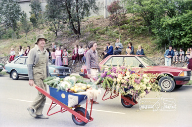
Photograph, Eltham Festival Parade, 16 October 1982, 1982
Roll of negatives of the Eltham Festival Parade as it progresses along Main Road past the Catholic Church heading towards Bridge Street. Floats included the Tasmanian Wilderness Society with the Save the Franklin River campaign, and Diamond Valley Railway celebrating 21 years of passenger service as well as the Victorian Police Marching Band. A well known Eltham identity, Jock Read was asked to lead the Eltham Pony Club contingent that year and the roll includes several shots of Jock on his horse, Lofty who was approximately ten years of age, his colour was still classed as a steel grey at the time before he went "white" quite a few years later. 1982: 16-17 October. “Pioneers of Eltham” and tractor (rain) Neswletter No. 27, November 1982 Although our parade entry did not win a prize this year, it was considered highly successful from a participation point of view. Despite some uncertainty as to just who was coming, members and friends kept appearing at the assembly area. As in the past years our friends from the Victorian Folk Music Club brought their instruments along and really added to the occasion. This year we concentrated on a rural theme with a tractor/trailer combination. Thanks to Peter Bassett-Smith for the tractor, Joh Ebeli for the decorations and friendly trailer owner Dennis McKay. Unfortunately the closing stages of the parade were marred by heavy rain. We just finished as the rain started but members scattered very quickly. This has prompted the suggestion for future parades that we have a tent or other suitable venue for members to gather after the event. This is worth following up. The cold driving rain provided a special problem for Peter in driving his tractor home to Kangaroo Ground. Have you ever had to choose between standing up to warm your hands on the exhaust and having your tractor seat flooded? Certificate, Festival Parade Award, Rotary Club of Eltham, Eighth Eltham Community Festival 1982. Presented to the Shire of Eltham Historical Society for the most effort by "locals"Roll of 35mm colour negative film, 24 shotsKodak Safety Film 5035eltham festival, catholic church, diamond valley railway, eltham, eltham district historical society, eltham parade, festivals, eltham fire brigade, eltham horse and pony club, jock read, learning co-op primary school, eltham living and learning centre, lofty (horse), main road, marching band, montmorency scouts, parade, parade floats, peter bassett-smith, research pre-school, roller city, shire of eltham historical society, victorian police -
 Streatham and District Historical Society
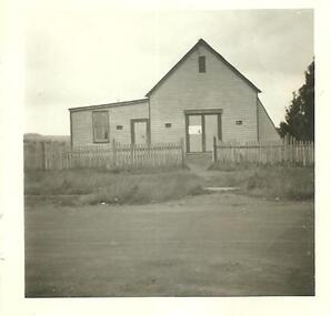
Picture, Streatham Hall
This shows the typical building structures of the time period. As the population grows in the area the need for a community meeting place becomes a requirement for the community. Local community rely on each other for company, support and social engagements.This building demonstrats the needs of the local community and the population in and around Streatham in 1888.Square picture in black and white showing the Streatham Hall. The picture is a shot of the front of a single storey weatherboard building with two doorways and one window in view. There is a picket fence running across the front of the building,Back: Stamped in green ink "317"building, rural, streatham, structures, areas, materials -
 Eltham District Historical Society Inc
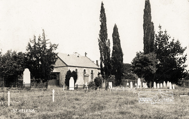
Photograph postcard, St. Helena church; postcard dated December 1907
This is an early view of the historical church and precinct. Statement of Significance Last updated on - October 10, 2005 St Helena's is a rare surviving example of a churchyard cemetery. It is of local historical significance because of its association with the local pioneering family, the Beales, and other notable citizens including Walter Withers and Graham Webster. The cemetery is also the oldest in the municipality, of State significance. The high level of maintenance and the rural ambience contribute to the overall significance of the site. St Katherine's Church building has been reconstructed and is of local historical interest, principally for its value in interpreting the original setting within the Cemetery. It contains stained glass windows of local historical significance, commemorating casualties of the Beale family in World War One. - Victorian Heritage DatabaseDigital file only Postcards scanned from the collection of Michael Aitken on loan to EDHS, 13 Feb 2018michael aitken collection, postcards, st helena, st katherine's church -
 Federation University Historical Collection
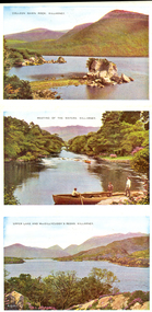
Letter Card, Six View Letter card of Killarney, Ireland
Probably acquired because of its connection to rural life and the Irish immigrants settled in the Ballarat DistrictSix coloured images from Killarney, Ireland. * Colleen Gawn Rock * Meeting of the Waters * Upper Lake and MacGillycuddy's Reeks, Killarney * The Islands, Upper Lake * Kate Kearney's Cottage * Lower Lake and Ross Castlechatham-holmes family archive, killarney, ireland -
Federation University Historical Collection
Booklet, Rural Education Conference Ballarat: Collected Papers of J.T. Turner, 1979
... of View * Farmer's Point of View * Concern About Rural Education... include: * Principal's Point of View * Teacher's Point of View ...Yellow covered with black plastic spine. Contents include: * Principal's Point of View * Teacher's Point of View * Student's Point of View * Farmer's Point of View * Concern About Rural Education * The Nathalia Study * Low-Achiever's Study * The Penal Colony * "Assistance", "Bounty" and "Wakefield" Settlers * Rural Urbanization (1810-1895) * "The Rush to be Rich" * Selection ballarat school of mines, tafe, county education project, j.l. turner, f.e. emery -
 Bendigo Historical Society Inc.
Photograph - HOUSE IN LANDSCAPE VIEW, 1960's ?
Hand tinted photo: photo of house in rural setting with autumn toned trees. Photo appears to have been taken at Daylesford or Hepburn Springs. House is small cottage, set in front of pine forest rising on hill to rear. Large eucalypts on right with road just evident on extreme right of photo.F. T. Kennedyplace, building, rural cottage -
 Buninyong & District Historical Society
Photograph - Photograph colour of Green Hill, View of Green Hill from Ballarat Institute of Advanced Education (Federation University) site, 1968
Colour photograph of site of Ballarat Institute of Advanced Education 1968 showing Green HillThe construction of the Mt. Helen campus in the 1970s in the predominately rural area was an important milestone in the expansion of tertiary education in the Central HighlandsColour photograph from Ballarat Institute of Advanced Education construction site toward Green Hill 1968Mt. Helen Site - Eastern end towards Green Hill 1968education, ballarat institute of advanced education, federation university, landscape, mt. helen, green hill -
 Buninyong & District Historical Society
Photograph - Photograph colour of site of Mt Helen Ballarat Institute of Advanced Education 1968, View of Ballarat Institute of Advanced Education (Federation University) site Mt Helen, 1968
Colour photograph of site of Ballarat Institute of Advanced Education 1968 showing Mount BuninyongThe construction of the Mt. Helen campus in the 1970s in the predominately rural area was an important milestone in the expansion of tertiary education in the Central HighlandsColour photograph of Ballarat Institute of Advanced Education site Mt Helen toward Mount Buninyong1968Mt. Helen - Towards Mt Buninyong from N.W. 1968 Before Campus Beginseducation, ballarat institute of advanced education, federation university, landscape, mt. helen, mount buninyong -
 Benalla Art Gallery
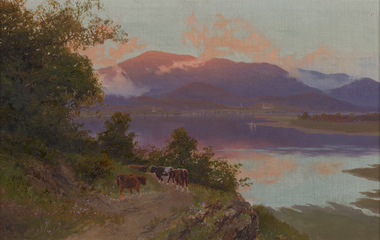
Painting, W. C. PIGUENIT, Mt Wellington at sunrise: a view from Risdon Cove towards Glenorchy, c. 1870
Born: Hobart, Tasmania, Australia 1836; Died: Hunter's Hill, New South Wales, Australia 1914RomanticismLedger Gift, 1976Rural landscape with cows, track, lake and large mountains and clouds. Golden gesso painted timber frame.Recto: Signed "W. C. Piguenit" in black oil in l.l.c of composition; Not dated; Not titledpainting, landscape, water, animals, cows, boats, trees, mountains, clouds, sky, colonial, reflections