Showing 10464 items
matching section
-
 Greensborough Historical Society
Poster - Planning Document, Shire of Diamond Valley et al, Subdivision Plan # 1018 - Parish of Nillumbik, County Bourke, Crown Allotment 4 Section 15, and Crown Allotment B Section 12, Eltham North, 1981-1982
Subdivision Plan # 1018 - Parish of Nillumbik, County Bourke, Crown Allotment 4 Section 15, and Crown Allotment B Section 12, Eltham North. This subdivision plan includes Ryans Road (also known as Government Road) and St Clems Street. The developer for this subdivision is Taunton Developments and the Surveyors are Fisher Cleeland Turner & Dwyer Vic, Surveyors and Engineers.An example of hard copy subdivision plans from the Greensborough area. Mainly from the Shire of Diamond Valley era (1964-1994).Plan (single sided) mounted on heavy card. Stamped and handwritten Council permissions, dates and other details. subdivision plans, shire of diamond valley, taunton developments -
 Melbourne Tram Museum
Document - Report, Melbourne & Metropolitan Tramways Board (MMTB), "Section to Section trips compiled from information obtained by the Melbourne Metropolitan Transportation Study 1964 Card survey.", Mar. 1967
Report - Foolscap landscape format, red tape binding - approx. 30 pages with notes, diagrams, charts, maps showing passenger traffic for parts of each route. Titled "Section to Section trips compiled from information obtained by the Melbourne Metropolitan Transportation Study 1964 Card survey from tram and bus routes based on the Central Business area of Melbourne". Dated 3/1967. Contains a large fold out map of each route showing passenger numbers for the day.In top right hand corner "Lees" in inktrams, tramways, mmtb, tramways, melbourne, surveys, passengers, maps -
 Federation University Historical Collection
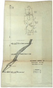
Plan, Sulieman Pasha Co Plan Transverse Section
The Sulieman Pasha is possibly named after the most important Sultan of the Ottoman Empire, Suleiman One, or Suleiman the Magnificent, when the Ottoman Empire was at its peak. Or potentially a number of Ottoman governors, statesmen and military commanders with the same name after, however the spelling is slightly different to the mine name. No Turkish connection was found relating to the formation of the company, and remains unconfirmed. The mine operated from two shafts; No. 1 near the corner of Humffray and Mair streets, and also near where the Welcome Nugget (2217 ounces) was found years earlier; and the controversial No. 2 shaft several blocks south bordering the northern side of the main highway through Ballarat. The company produced 62 666 ounces of gold, the twelfth highest quartz reef gold production for any mine on the Ballarat goldfield. Some crushing figure examples are January-June 1881: 3674 tonnes 1085 ounces; January-June 1885: 2949 tonnes 1281 ounces; July-December 1885: 4459 tonnes 1119 ounces; January-June 1887: 1869 tonnes 730 ounces; July-December 1892: 1450 tonnes 771 ounces; July-December 1896: 4365 tonnes 1372 ounces. Like many mines in the area, gold grades were low. John Watson was noted as mine manager in the 1880s, and John Williams 1890s. The company was re-organised twice increasing the number of shares from 4000 to 24 000, and increasing the capital available. The Sulieman Pasha Company was formed in 1878. David Fitzpatrick was given the honour of turning the first sod of both the No.1 and later No. 2 shafts. The first dividend was given to shareholders in July 1881. The company obtained a prospecting vote (government grant) to start, and was very proud to be the first Victorian gold mining company to pay the funds back to the government. The event was marked by a lavish banquet laid out for ministers and government officials by the company. Leases were purchased to the south in 1885 to the Llanberris Mine boundary, after poor results began accumulating from the small No. 1 shaft. To take advantage of this new land the company planned to sink a second shaft. Initially this was to take place on government land, but the uproar from nearby residents caused the company to purchase land along the Main Road (now Western Highway), and the old Yarrowee Hotel which had occupied the site since the alluvial digger days of the 1850's was demolished. The area had since those days become heavily occupied with a number of shops, houses, a post office, church and two schools in the immediate area. The thought of an underground mine next door drew considerable opposition. The company (before the days of public relations departments) wrote 'most people would have thought that progress as vital as mining would be supported by tradesmen whose business rely on the mining industry. It seems when it comes to mining they are bereft of their senses, and considering the low ebb of mining in Ballarat East, the action of our opponents are unaccountable. (Sarcastically) There are certain engineering difficulties in moving the quartz reefs to a new location, but if we could to appease our opponents we would'. The company also wanted to take over 4 acres of the St Paul's school oval for machinery, but accused the St Paul's Church of wanting extortionate amounts of money upfront, and on a yearly basis for the privilege. It stated the church could not be opposed to mining when several years earlier it had formed its own company to mine the land, only for shareholders to lose their money. In 1886, the company approached the Minister for Mines, and attended heated public meetings on the matter. The local residents, shop owners, and church submitted a 60 person petition to the local council and government authorities. They stated the shaft contravened the mining statutes, which stating no mining could take place within 150 yards of a public building or church. A speech by a resident stated 'mining always comes with glorious pictures of the great benefits which would accrue all parties concerned if their request is granted, but if property is destroyed or depreciated in value, no-one then comes forward and compensates them'. The No. 2 shaft was approved including taking over part of the school oval. In 1888, workers at the company's No. 2 shaft went on strike to try and bring their wages in line with other mines in the district (the No. 1 shaft was operated by tributers). William Madden (26) was killed from a fall of earth underground the same year, while a year later his father John Madden (70) was similarly killed in the Madame Berry Mine elsewhere in the district. In 1897 as the amount of gold being found fell away, it came to light part of the deal to purchase the Yarrowee Hotel site was a 5% royalty on gold found. Shareholders could not understand why they were paying a royalty to the former owners of the property. The mine closed in 1898 due to a lack of gold. In 1902 a boy (age unknown) called Charles Lee was killed from a fractured skull while working to dismantle the Sulieman Pasha plant. The fuss over the No. 2 shaft had a sequel. On the company winding up, the land was purchased by J.S. Trethowan who built a house next to the shaft. In 1907, the shaft caved-in creating a sinkhole immediately at the back of the house. A Mr Chamberlain heard a deep rumbling sound at 5am, and looked out the window to see his fowl house and thirteen chickens disappear down an expanding hole. He then went back to bed, and called the police later in the day. The shaft was 1050 feet deep, and the hole at the surface that developed was 20 feet by 17 feet across, and 20 feet depth. In 1930 it is reported a syndicate had been formed to clean out the old shaft, and re-open the mine. It is assumed this was the No. 1 shaft but no more was found. (https://www.mindat.org/loc-304239.html, accessed 07/08/2019) A transverse section plan of the Sulieman Pasha Mine.sulieman pasha company, plan, mining, united black hill mine, victoria united mine, victoria street, britannia united mine, last chance mine, llanberris mine, ottoman empire, john watson, john williams, david fitzpatrick -
 Whitehorse Historical Society Inc.
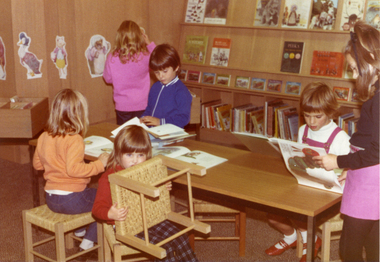
Photograph, Children's Section of Nunawading Library
Coloured photo of Children's Section of Nunawading Library.nunawading library -
 Ballarat Heritage Services
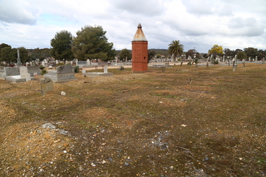
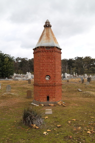
Photograph - Photograph - Colour, Clare Gervasoni, Chinese Section in the Bendigo Cemetery, 2018, 01/09/2018
Colour photograph of the Chinese section in the Bendigo Cemetery.bendigo cemetery, graves, headstones, chinese, lee kie -
 Ballarat Heritage Services
Photograph - Photograph - Colour, Clare Gervasoni, Chinese Section in the Bendigo Cemetery, 2018, 01/09/2018
Colour photograph of the Chinese section in the Bendigo Cemetery.A plaque states: This Pomelo Tree (known to the Chinese as the tree of life) was planted on 9 October 1996 in recognition and to the memory of the many Chinese buried at or in close proximity to this site during the 19th and 20th centuries. bendigo cemetery, graves, headstones, chinese, oven -
 Stawell Historical Society Inc
Map, Section 3 (Taken from Plan No 959), 1894
Section 3 (Taken from Plan No 959)stawell -
Stawell Historical Society Inc
Map, Section 2 (Taken from Plan No 959), 1894
Section 2 (Taken from Plan No 959)stawell -
Stawell Historical Society Inc
Map, Section 4 (Taken from Plan No 959), 1894
Section 4 (Taken from Plan No 959)stawell -
Stawell Historical Society Inc
Map, Section 5 (Taken from Plan No 959), 1894
Section 5 (Taken from Plan No 959)stawell -
Creswick Campus Historical Collection - University of Melbourne
Education kit - 3D Model of plant stem structure, Biocalderoni KFT, Stem cross section of plant
3D cross section of microscopic view of a plant stem. -
Stawell Historical Society Inc
Map, Section of Map, Stawell including Stawell Rifle Range, 1969
Section of Map, Stawell including Stawell Rifle Rangestawell -
 Kew Historical Society Inc
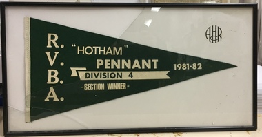
Award, RVBA, "Hotham" Pennant Division D4 Section Winner, 1981-2
Sports Clubs in Kew in the final decades of the 19th century and in the early 20th century were often umbrella organisations with facilities for a number of sports. Typically in Kew, this included teams in lawn bowls, tennis and croquet. The Kew Bowling Club was formed in 1880 while the privately owned Auburn Heights Recreation Club was opened in 1904. By 1998, the two Clubs decided to amalgamate at the Auburn Heights site in Barkers Road, forming the Kew Heights Sports Club. The combined club was itself taken over by the Melbourne Cricket Club in 2012 becoming MCC Kew Sports Club. In 2017 MCC Kew closed and its landholding was subsequently sold to Carey Baptist Grammar School. Both the Kew and Auburn Heights Clubs assembled important collections. These historically significant and large collections were donated to the Society in 2020. The collections include manuscripts, pictures, trophies, plans, honour boards etc. References Barnard FGA 1910, 'Sports and Pastimes' in Jubilee History of Kew Victoria: Its origin & progress 1803-1910. Chapman J & C 1999, The history of the Auburn Heights Recreation Club, 1904 to 1908. Reeve S 2012, City of Boroondara: Thematic Environmental History, p.216.The combined collections of the four sporting clubs making up the collection number hundreds of items that are historically significant locally. They are also significant to the sporting history of the greater Melbourne area and to the sports of lawn bowls and tennis in Australia in the 19th and 20th centuries. The collection illuminates two of the Victorian historic themes - 'Building community life' through forming community organisations and 'Shaping cultural and creative life' by participating in sport and recreation.Framed and glazed Auburn Heights Recreation Club pennant won by a team from the Men's Bowling Club. [The item forms part of the large historic Auburn Heights Recreation Club collection, with items relating to the sports of lawn bowls, tennis and croquet, gifted to the Kew Historical Society in 2020].R.V.B.A. / "HOTHAM" PENNANT DIVISION 4 SECTION WINNER 1981-82 / AHRCauburn heights recreation club - barkers road - kew (vic), sports clubs - kew (vic) - pennants, auburn heights men's bowling club - barkers road - kew (vic) -
Stawell Historical Society Inc
Archive - Plan, Stawell Water Supply, Stawell Water Supply Plan and Section of Valve House, c 1878
Part of Infrastructure on Big Hill For Stawell Water Supply Large Technical drawing of Piping Significant Tears and Sections MissingScale 4 ft to 1 inch -
 Ringwood and District Historical Society
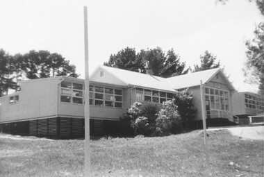
Photograph, External views of North Ringwood State School in Oban Road, including newly completed section - December 1972
Written on back of photograph, "North Ringwood State School. New section, Dec. 1972". -
 National Wool Museum
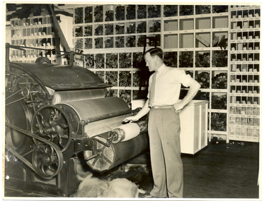
Photograph, Blending section
Colour blending, R S & S mill.Blending section/ Alf Harper - the colour blender ROBERT POCKLEY/ PHOTOGRAPGER G Kidmantextile machinery textile mills - history textile mills - staff textile mills, returned soldiers and sailors mill, blending, colour blending, finishing, harper, mr alfred - returned soldiers and sailors mill kidman, mr g. l., textile machinery, textile mills - history, textile mills - staff, textile mills -
 Buninyong & District Historical Society
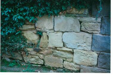
Photograph - Original Photograph, C J Brooks, Section of sandstone wall, 405 Learmonth St. Buninyong, July 1995
Stone of which wall is constructed is believed to have been used in the construction of Jamieson's Buninyong Inn, built for Margaret Jamieson starting about 1853. She owned the earlier Buninyong Inn which impinged on they surveyed Learmonth St. and was demolished. Margaret died in 1854 before the building was completed by her son, who built the third Buninyong Inn on the corner of Learmonth and Warrenheip. The two story hotel was tenented for a while, then bought by Dr. Sparling who demolished it.Colour photo, Section of sandstone wall, 405 Learmonth St. Buninyong.buninyong, jamieson, sparling, buninyong inn, wall, sandstone -
 Melton City Libraries
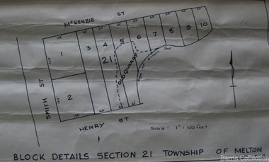
Map, Block details section 21 Township of Melton, 1965
In 1861, Mary Dowling and John Luby obtained Crown Grant land on the corner of Smith and McKenzie Street Melton.Section 21 is covers the block of Smith, Henry and McKenzie Street Meltoncouncil -
 Melbourne Tram Museum
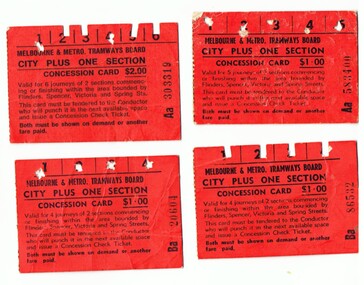
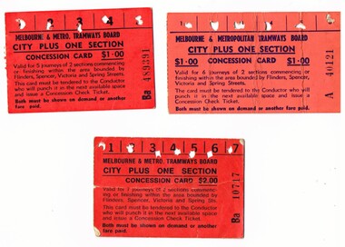
Ephemera - Ticket/s, Melbourne & Metropolitan Tramways Board (MMTB), Set of four City Plus One Section cards, mid to late 1970's
Set of four City Plus One Section cards, issued by the MMTB printed on red card. All used. Trip numbers. vary. .1 "City Plus One Section" - printed on red card, allowed for six trips within the city section and the next section. Has been used . Cost $2.00. Ticket Number Aa303319 .2 - ditto, five trips - Aa583400 - cost $1.00 .3 - ditto, four trips, cost $1.00, Ba 86532 and Ba20604.trams, tramways, mmtb, ticket, city section -
 Kew Historical Society Inc
Plan - Subdivision Plan, Boulevard Estate - Boulevard Section, 1930-1936
Pru Sanderson, in her groundbreaking ‘City of Kew Urban Conservation Study : Volume 2 - Development History’ (1988), summarised the periods of urban development and subdivisions of land in Kew. The periods that she identified included 1845-1880, 1880-1893, 1893-1921, 1921-1933, 1933-1943, and Post-War Development. These periods were selected as they represented periods of rapid growth or decline in urban development. An obvious starting point for Sanderson’s groupings involved population growth and the associated economic cycles. These cycles also highlighted urban expansion onto land that was predominantly rural, although in other cases it represented the decline and breakup of large estates. A number of the plans in the Kew Historical Society’s collection can also be found in other collections, such as those of the State Library of Victoria and the Boroondara Library Service. A number are however unique to the collection.The Kew Historical Society collection includes almost 100 subdivision plans pertaining to suburbs of the City of Melbourne. Most of these are of Kew, Kew East or Studley Park, although a smaller number are plans of Camberwell, Deepdene, Balwyn and Hawthorn. It is believed that the majority of the plans were gifted to the Society by persons connected with the real estate firm - J. R. Mathers and McMillan, 136 Cotham Road, Kew. The Plans in the collection are rarely in pristine form, being working plans on which the agent would write notes and record lots sold and the prices of these. The subdivision plans are historically significant examples of the growth of urban Melbourne from the beginning of the 20th Century up until the 1980s. A number of the plans are double-sided and often include a photograph on the reverse. This plan shows a subdivision with two sections: the ‘Boulevard Section’ and the ‘Riverside Section’. The first of these sections bordered Burke Road between Kilby Road and the farm beside the Yarra. Kilby Road, Munro Road, Burke Road and Old Burke Road bordered the 102 lots in the Boulevard Section of the plan. The streets within the Section included Walbundry Avenue, Inverness Way, Riverside Avenue, Cascade Street and Kyora Parade. These street names, at least in this subdivision plan linked the two Sections of the subdivision. At a later date, the City of Kew decided to alter the street names. Walbundry, Inverness, Riverside, Cascade and Kyora were all renamed as ‘Drives’ (e.g. Kyora Drive). The subdivision plan is of interest in that it names High Street in Kew as Doncaster Road. It also shows the location of the wooden church that was later removed to Yarraville on the corner of Kilby Road and High Street. The plan predates later developments such as the S. E. Dickens Supermarket.subdivision plans - east kew, boulevard estate, munro road -- kew east (vic.), kilby road -- kew east (vic.), burke road -- kew east (vic.), walbundry avenue -- kew east (vic.), inverness way -- kew east (vic.), riverside avenue -- kew east (vic.), cascade drive -- kew east (vic.), nyora parade -- kew east (vic.) -
University of Melbourne, Burnley Campus Archives
Plan, Crops Section, 1959-1983
(1) Undated photocopy, not much detail. (2) 'Crops Section 1980's', details with dates 1980-1983. (3) 'Crops Section Responsibilities 1980', labelled with initials. (4) Plans with very little detail, some areas marked, 'Plots 80-82'. (5) 'Crops Section - Burnley (1959?). (6) 'Replanting for students' Rows 6,7,8, 1crops, burnley -
 Ringwood and District Historical Society
Photograph, New market - View of goods intake section 'Target'. Ringwood 1982
Written on back of photograph, "E648. 8/1/82. View of goods intake section 'Target'". -
 Ringwood and District Historical Society
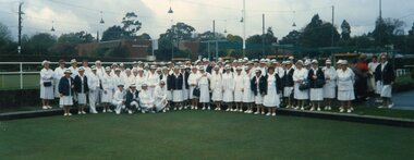
Photograph, Ringwood Bowls Club- Group photograph of Ladies Section, Opening Day 1996/97 season
Coloured photographGroup photograph of Ladies Section bowlers on Opening Day- 1996/97 season. No names listed. -
 Melbourne Tram Museum
Ephemera - Ticket/s, Melbourne & Metropolitan Tramways Board (MMTB), "City plus one Section concession card", mid to late 1070's and 1980's
Set of four section multiple journey concession cards, issued by the MMTB mid 1970's; .1 One "City Plus One Section" - printed on red card, allowed for six trips within the city section and the next section. Has been used . Cost $1.00. Ticket Number A40121. .2 - ditto, cost $2.00, eight trips Ba 10717. .3 - ditto, cost $1.00, 5 trips - Ba 489391 See also Reg Item 938 for examples, but different prices and arrangements.trams, tramways, mmtb, tickets, city section, melbourne -
 Flagstaff Hill Maritime Museum and Village
Document - Map, Department of Lands & Survey, Victoria / Panmure, 1942
This Emergency Edition of the map of Panmure, Victoria, is part of the W.R. Angus Collection. It was printed in 1942 during World War II. It is one of two maps donated to Flagstaff Hill Maritime Village by the family of Doctor William Roy Angus, who served as Surgeon Captain in the Australian Defence Department. The map was compiled for the Dept. of Army by the Dept. of Lands and Survey in Melbourne, prepared by the Australian Section of the Imperial General Staff, which was a British Government body created in 1907 to co-ordinate the defence of Britain and its Empire. It was printed by A.H.Q. Cartographic Company, Survey Corps, which was formed in 1941. The Corp changed its name to L.H.Q. Cartographic Company of Bendigo. In 1947 the name reverted back to the A.H.Q. Cartographic Company until 1955 when it became the A.H.Q. Survey Regiment. The W.R. Angus Collection includes historical medical equipment, surgical instruments and material once belonging to Dr Edward Ryan and Dr Thomas Francis Ryan, (both of Nhill, Victoria) as well as Dr Angus’ own belongings. The Collection’s history spans the medical practices of the two Doctors Ryan, from 1885-1926 plus that of Dr Angus who began practice in 1924. Dr. Angus served with the Australian Department of Defence as a Surgeon Captain during the Second World Was from 1942 to 1945. He served in Ballarat, Victoria, and in Bonegilla, N.S.W. until he suffering from a heart attack just before the war ended. ABOUT THE “W.R.ANGUS COLLECTION” - Doctor William Roy Angus M.B., B.S., Adel., 1923, F.R.C.S. Edin.,1928, was generally known as Dr Roy Angus. His working life included a position as a doctor with the Flying Doctor Service in Australia’s rural and remote areas. After many varied experiences Dr Angus and his family moved to Warrnambool in 1939 where he purchased “Birchwood,” the 1852 home and medical practice of Dr John Hunter Henderson. He was appointed on a part-time basis as Port Medical Officer in Warrnambool and held this position until the 1940’s when the government no longer required the service of a Port Medical Officer. Dr Angus was a surgeon at the Warrnambool Base Hospital 1939-1942. After further studies he commenced practice as an ophthalmologist in Warrnambool, pioneering in artificial eye improvements. He was Honorary Consultant Ophthalmologist to Warrnambool Base Hospital for 31 years and made monthly visits to Portland to perform eye surgery. Dr Angus and his wife Gladys were very involved in Warrnambool’s community with a strong interest in civic affairs. They were both involved in the creation of Flagstaff Hill Maritime Village, including the layout of the gardens. After his death on 28th March 1970 his family requested his practitioner’s plate, medical instruments and some personal belongings be displayed in the Port Medical Office surgery at Flagstaff Hill Maritime Village, and be called the “W. R. Angus Collection”. This Emergency Edition of the Map of Panmure is significant as an example of the documents prepared for the defence of Australia in World War 2. The Map is also significant for its connection between the Australian Army and the involvement of Dr WR Angus as a Surgeon in the Medical Services during World War II. The W.R. Angus Collection is significant for still being located at the site it is connected with, Doctor Angus being the last Port Medical Officer in Warrnambool. The collection of medical instruments and other equipment is culturally significant, being an historical example of medicine, administration, household equipment and clothing from late 19th to mid-20th century. Dr Angus assisted Dr Tom Ryan, a pioneer in the use of X-rays and in ocular surgery. The collection includes Dr Angus’s Army objects and is significant as an example of items issued to Doctors and Surgeons in the Medical Services of the Australian Army in World War IIMilitary map of Panmure, Victoria, Australia; part of the W.R. Angus Collection. Rectangular coloured map on cream paper for the Australian Army. Details include sea, waterways and land, contour lines, grid lines, names of districts, towns and roads, bridges, swamps, rail lines, cuttings, tracks, buildings (including blacksmiths), pumps, lighthouses, telegraph, telephones and electric transmission lines, and fire stations. The map has margin notes that include distances in miles to nearby towns. The map was compiled for the Dept. of Army by the Dept. of Lands and Survey in Melbourne, prepared by the Australian Section, Imperial General Staff and printed by A.H.Q. Cartographic Company, Melbourne in 1942. Crown Copyright Reserved. Inscriptions in red print state that it is and Emergency Edition and an Official document. An oval purple stamp includes the price.Printed in black; 'Victoria / Panmure", "No. 930 / Zone 6" Printed in red; “EMERGENCY EDITION”, “THIS MAP IS AN OFFICIAL DOCUMENT. IF FOUND, IT MUST BE HANDED / IN TO THE NEAREST MILITARY HEADQUARTERS OR POLICE STATION” Stamped: within concentric ovals (“- - - FOR SALE / PRICE 2/- / - - - - - OF THE ARMY”)flagstaff hill, warrnambool, flagstaff hill maritime museum, maritime museum, shipwreck coast, flagstaff hill maritime village, great ocean road, dr w r angus, dr ryan, warrnambool base hospital, flying doctor, surgeon captain, australian department of defence, royal australian army, world war 2, map panmure 1942, roy angus, port medical officer, nhill base hospital, military map, emergency map, military service australian army, department of army, department of lands and survey, a.h.q. cartographic company melbourne, panmure 1942, australian section, imperial general staff -
 Flagstaff Hill Maritime Museum and Village
Document - Map, Department of Lands & Survey, Victoria / Port Campbell, 1942
This Emergency Edition of the map of Port Campbell, Victoria, is part of the W.R. Angus Collection. It was printed in 1942 during World War II. It is one of two maps donated to Flagstaff Hill Maritime Village by the family of Doctor William Roy Angus, who served as Surgeon Captain in the Australian Defence Department. The map was compiled for the Dept. of Army by the Dept. of Lands and Survey in Melbourne, prepared by the Australian Section of the Imperial General Staff, which was a British Government body created in 1907 to co-ordinate the defence of Britain and its Empire. It was printed by A.H.Q. Cartographic Company, Survey Corps, which was formed in 1941. The Corp changed its name to L.H.Q. Cartographic Company of Bendigo. In 1947 the name reverted back to the A.H.Q. Cartographic Company until 1955 when it became the A.H.Q. Survey Regiment. The W.R. Angus Collection includes historical medical equipment, surgical instruments and material once belonging to Dr Edward Ryan and Dr Thomas Francis Ryan, (both of Nhill, Victoria) as well as Dr Angus’ own belongings. The Collection’s history spans the medical practices of the two Doctors Ryan, from 1885-1926 plus that of Dr Angus who began practice in 1924. Dr Angus served with the Australian Department of Defence as a Surgeon Captain during the Second World Was from 1942 to 1945. He served in Ballarat, Victoria, and in Bonegilla, N.S.W. until he suffering from a heart attack just before the war ended. ABOUT THE “W.R.ANGUS COLLECTION” - Doctor William Roy Angus M.B., B.S., Adel., 1923, F.R.C.S. Edin.,1928, was generally known as Dr Roy Angus. His working life included a position as a doctor with the Flying Doctor Service in Australia’s rural and remote areas. After many varied experiences Dr Angus and his family moved to Warrnambool in 1939 where he purchased “Birchwood,” the 1852 home and medical practice of Dr John Hunter Henderson. He was appointed on a part-time basis as Port Medical Officer in Warrnambool and held this position until the 1940’s when the government no longer required the service of a Port Medical Officer. Dr Angus was a surgeon at the Warrnambool Base Hospital 1939-1942. After further studies he commenced practice as an ophthalmologist in Warrnambool, pioneering in artificial eye improvements. He was Honorary Consultant Ophthalmologist to Warrnambool Base Hospital for 31 years and made monthly visits to Portland to perform eye surgery. Dr Angus and his wife Gladys were very involved in Warrnambool’s community with a strong interest in civic affairs. They were both involved in the creation of Flagstaff Hill Maritime Village, including the layout of the gardens. After his death on 28th March 1970 his family requested his practitioner’s plate, medical instruments and some personal belongings be displayed in the Port Medical Office surgery at Flagstaff Hill Maritime Village, and be called the “W. R. Angus Collection”. This Emergency Edition of the Map of Port Campbell is significant as an example of the documents prepared for the defence of Australia in World War 2. The Map is also significant for its connection between the Australian Army and the involvement of Dr WR Angus as a Surgeon in the Medical Services during World War II. The W.R. Angus Collection is significant for still being located at the site it is connected with, Doctor Angus being the last Port Medical Officer in Warrnambool. The collection of medical instruments and other equipment is culturally significant, being an historical example of medicine, administration, household equipment and clothing from late 19th to mid-20th century. Dr Angus assisted Dr Tom Ryan, a pioneer in the use of X-rays and in ocular surgery. The collection includes Dr Angus’s Army objects and is significant as an example of items issued to Doctors and Surgeons in the Medical Services of the Australian Army in World War IIMilitary map of Port Campbell, Victoria, Australia; part of the W.R. Angus Collection. Rectangular coloured map on cream paper for the Australian Army. Details include sea, waterways and land, contour lines, grid lines, names of districts, towns and roads, bridges, swamps, rail lines, cuttings, tracks, buildings (including blacksmiths), pumps, lighthouses, telegraph, telephones and electric transmission lines, and fire stations. The map has margin notes that include distances in miles to nearby towns. The map was compiled for the Dept. of Army by the Dept. of Lands and Survey in Melbourne, prepared by the Australian Section, Imperial General Staff and printed by A.H.Q. Cartographic Company, Melbourne in 1942. Crown Copyright Reserved. Inscriptions in red print state that it is and Emergency Edition and an Official document. An oval purple stamp includes the price.Printed in black; 'Victoria / Port Campbell", "No. 932 / Zone 6" Printed in red; “EMERGENCY EDITION”, “THIS MAP IS AN OFFICIAL DOCUMENT. IF FOUND, IT MUST BE HANDED / IN TO THE NEAREST MILITARY HEADQUARTERS OR POLICE STATION” Stamped: within concentric ovals (“- - - FOR SALE / PRICE 2/- / - - - - - OF THE ARMY”)flagstaff hill, warrnambool, flagstaff hill maritime museum, maritime museum, shipwreck coast, flagstaff hill maritime village, great ocean road, dr w r angus, dr ryan, warrnambool base hospital, nhill base hospital, flying doctor, surgeon captain, map port campbell 1942, roy angus, port medical officer, military map, emergency map, australian department of defence, royal australian army, military service australian army, department of army, department of lands and survey, world war 2, a.h.q. cartographic company melbourne, australian section, imperial general staff, port campbell 1942 -
 Ringwood and District Historical Society
Photograph, First section of bowling club and infant cypress. Houses in Adelaide Street Ringwood. (undated but probably late 1930's)
Photo with ducks superimposed and pencilled note "Ducks on Ringwood Bowling Green"Written on back of photograph, "Shows first section of bowling club and infant cypress. Houses in Adelaide St." -
Moorabbin Air Museum
Document (item) - Recognition Handbook of British Aircraft Air Publication 1480A Part 1 Section A to D
World War 2 British Aircraft Identification HandbookRECOGNITION HANDBOOK OF BRITISH AIRCRAFT AIR PUBLICATION 1480A Sections A to D Master copy written in pencilworld war 2 aeroplanes, second world war british aeroplane recognition handbook -
 Ringwood and District Historical Society
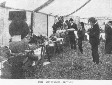
Photograph, Ringwood Horticultural Show, the Vegetable Section - 1902, 1902
Black and white photograph. (2 copies)Written on back of photograph: Ringwood Horticultural Show- Vegetable Section, 1902. Weekly Times 29-3-1902. -
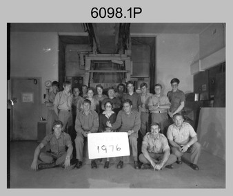 Bendigo Military Museum
photograph - Camera Section, Lithographic Squadron at the Army Survey Regiment, Bendigo, 1976, 1978 and 1979
This is a set of four photograph of Camera Section, Lithographic Squadron, one of the Army Survey Regiment’s four squadrons, at Fortuna, Bendigo in 1976, 1978 and 1979. The main tasks undertaken by Camera Section’s technicians were photographic enlargements, reductions and duplication of map reproduction material, and processing of aerial photography. Photo .2P and its enlargement (.3P) was taken with Camera Section in front of the Klimsch Commodore camera on the 5th of October 1978, before its decommissioning. It was replaced with a new Klimsch model with computerised control, improved speed and consistent controlled output.This is a set of four photograph of Camera Section, Lithographic Squadron, Army Survey Regiment at Fortuna, Bendigo, c1970s. The black and white photographs were printed on photographic paper and are part of the Army Survey Regiment’s Collection. The photographs were scanned at 300 dpi. .1) - Photo, black & white, 1976, Back Row L to R: unidentified, Garry Hudson, unidentified, Greg Kidman, unidentified, Bob Chamberlain, Mick ‘Buddha’ Ellis, Zoe (Lisiewich) Ames, Bill Jones, Trevor Osborne, Dave Miles, Chris Osborne. Front Row L to R: Frank Lenane, Gavin Neilson, Joanne Green, Warren ‘Waldo’ Shirley, Peter Coombes, John Nicholls. .2) & .3) - Photo, black & white, 5th Oct 1978, Back Row L to R: CPL Bob Chamberlain, Greg Kidman, SSGT George Graham, Chris Osborne, John Nicholls, Frank Lenane, Terry Edwards, Bill Jones, CAPT Gary Kenney, Peter Imeson. Front Row L to R: CPL Warren ‘Waldo’ Shirley, SPR Mick ‘Buddha’ Ellis, CPL Garran Hill. .4) - Photo, black & white, 1979, Back Row L to R: WO2 George Graham, CAPT Stan Vote, Peter Imeson, Gary Tremain, Penny Knott, Zoe (Lisiewich) Ames, Di Chalmers, Rob Bogumil, Bill Jones, Rhys De Laine, Brian Fauth, John McCracken. Front Row L to R: SGT Ralph Chant, SGT Garran Hill, CPL Gavin Neilson, Frank Lenane, Paul Baker, SSGT Trevor Osborne.No personnel are identified. Each photo is annotated on the front. .1P annotated ‘1976’ .2P &.3P annotated ‘CAMERA SECT 5 Oct 1978 The Last of the old Klimsch’ .3P annotated ‘Camera ‘79’royal australian survey corps, rasvy, army survey regiment, army svy regt, fortuna, asr, litho