Showing 288 items
matching settlement house
-
 Glenelg Shire Council Cultural Collection
Medal - Medallion- Portland's 150th Anniversary Celebrations 1984, BRIM MELBOURNE, c. 1984
In November 1984 Portland marked the 150th anniversary of European settlement and the foundation of the City of Portland. Various events happened in and around Portland, many community led. Syd Cuffe was the Portland Town Crier from 1983 to 2013. The role of Town Crier was created for Syd Cuffe in 1983 in the lead up to Portland’s 150th anniversary celebrations held in 1984-85. 200 items from Mr. Cuffe’s estate were donated to the Glenelg Shire Cultural Collection. The items relate to his town crying activities and community work across the Shire and further afield.Silver coloured medallion on green cord. Portland 150th Anniversary 1984, round edge on front, whale and triangle logo in centre. Spray of heath on reverse. Medal measures 3.1 cm x .1cm diameter.portland 150th anniversary -
Glenelg Shire Council Cultural Collection
Photograph - Photograph - Syd Cuffe, Town Crier, 19/11/1984
In November 1984 Portland marked the 150th anniversary of European settlement and the foundation of the City of Portland. Various events happened in and around Portland, many community led. Syd Cuffe was the Portland Town Crier from 1983 to 2013. The role of Town Crier was created for Syd Cuffe in 1983 in the lead up to Portland’s 150th anniversary celebrations held in 1984-85. 200 items from Mr. Cuffe’s estate were donated to the Glenelg Shire Cultural Collection. The items relate to his town crying activities and community work across the Shire and further afield.Coloured photo. Syd Cuffe in Town Crier's regalia on float with 3 people in period costume, Portland's 150th celebrations 1984.portlands 150th anniversary celebrations 1984 -
Glenelg Shire Council Cultural Collection
Photograph - Photograph - Syd Cuffe, Town Crier Portland's 150th Anniversary Celebrations 1984, 19/11/1984
In November 1984 Portland marked the 150th anniversary of European settlement and the foundation of the City of Portland. Various events happened in and around Portland, many community led. Syd Cuffe was the Portland Town Crier from 1983 to 2013. The role of Town Crier was created for Syd Cuffe in 1983 in the lead up to Portland’s 150th anniversary celebrations held in 1984-85. 200 items from Mr. Cuffe’s estate were donated to the Glenelg Shire Cultural Collection. The items relate to his town crying activities and community work across the Shire and further afield.Coloured photo. Royal Australian Navy members marching down Julia St as part of parade for Portland's 150th Anniversary celebrations.portlands 150th anniversary celebrations 1984 -
Glenelg Shire Council Cultural Collection
Photograph - Photograph - Syd Cuffe, Town Crier, 19/11/1984
In November 1984 Portland marked the 150th anniversary of European settlement and the foundation of the City of Portland. Various events happened in and around Portland, many community led. Syd Cuffe was the Portland Town Crier from 1983 to 2013. The role of Town Crier was created for Syd Cuffe in 1983 in the lead up to Portland’s 150th anniversary celebrations held in 1984-85. 200 items from Mr. Cuffe’s estate were donated to the Glenelg Shire Cultural Collection. The items relate to his town crying activities and community work across the Shire and further afield.Coloured photo of Syd Cuffe in his Town Crier's regalia, standing next to the fruit and vegetable section of Portland Supermarket. Portland's 150th Anniversary celebrations.portlands 150th anniversary celebrations 1984 -
Glenelg Shire Council Cultural Collection
Photograph - Photograph - Portland's 150th Anniversary Celebrations 1984, 19/11/1984
In November 1984 Portland marked the 150th anniversary of European settlement and the foundation of the City of Portland. Various events happened in and around Portland, many community led. Syd Cuffe was the Portland Town Crier from 1983 to 2013. The role of Town Crier was created for Syd Cuffe in 1983 in the lead up to Portland’s 150th anniversary celebrations held in 1984-85. 200 items from Mr. Cuffe’s estate were donated to the Glenelg Shire Cultural Collection. The items relate to his town crying activities and community work across the Shire and further afield.Coloured photo. Bullock team on Cliff St, part of parade for Portland's 150th Anniversary celebrations.portlands 150th anniversary celebrations 1984 -
Glenelg Shire Council Cultural Collection
Photograph - Photograph - Portland's 150th Anniversary Ball 1984, 17/11/1984
In November 1984 Portland marked the 150th anniversary of European settlement and the foundation of the City of Portland. Various events happened in and around Portland, many community led. Syd Cuffe was the Portland Town Crier from 1983 to 2013. The role of Town Crier was created for Syd Cuffe in 1983 in the lead up to Portland’s 150th anniversary celebrations held in 1984-85. 200 items from Mr. Cuffe’s estate were donated to the Glenelg Shire Cultural Collection. The items relate to his town crying activities and community work across the Shire and further afield.Coloured photo. Portland's 150th Anniversary ball, transit shed, KS Anderson wharf. View of stage, Australian Navy Band performing.portlands 150th anniversary celebrations 1984 -
Glenelg Shire Council Cultural Collection
Photograph - Photograph -Henty Beach, Portland's 150th Anniversary Celebrations 1984, 19/11/1984
In November 1984 Portland marked the 150th anniversary of European settlement and the foundation of the City of Portland. Various events happened in and around Portland, many community led.Coloured photo. Salvation Army band in period costume, Henty Beach, Portland's 150th Anniversary celebrations.portlands 150th anniversary celebrations 1984 -
Glenelg Shire Council Cultural Collection
Photograph - Photograph - Portland's 150th Anniversary Celebrations 1984, n.d
In November 1984 Portland marked the 150th anniversary of European settlement and the foundation of the City of Portland. Various events happened in and around Portland, many community led. Syd Cuffe was the Portland Town Crier from 1983 to 2013. The role of Town Crier was created for Syd Cuffe in 1983 in the lead up to Portland’s 150th anniversary celebrations held in 1984-85. 200 items from Mr. Cuffe’s estate were donated to the Glenelg Shire Cultural Collection. The items relate to his town crying activities and community work across the Shire and further afield.Coloured photo. Volunteer Battery Brigade - re-enactment group, parade Portland's 150th Anniversary celebrations.Back: 'M 24' - blue biro -
Glenelg Shire Council Cultural Collection
Medal - Medallion - centenary of Portland, 1934
Souvenir "Lt. James Grant 1800' on one side, 'Edward Henty / Centenary of POrtland Settlement 1834 - 1934' on the reversemedal, medallion, portland centenary -
Glenelg Shire Council Cultural Collection
Plaque - Plaque - Portland Vintage Car Club, Portland's 150th Anniversary, c. 1984
Enamelled brass plaque, oval, hole each end. Plain back, front green, enamelled border, with gold print, Portland Vintage Car Club Inc. Victoria's first Permanent Settlement. central area, pale gold, with 150th logo and gold print 'COMMEMORATES PORTLAND'S 15OTH ANNIVERSARY 1834 - 1984'vintage car, local society, portland 150th anniversary, 1834, 1984, plaque, souvenir, memorabilia -
Glenelg Shire Council Cultural Collection
Clothing - Apron - Portland 150th Anniversary, c. 1984
In November 1984 Portland marked the 150th anniversary of European settlement and the foundation of the City of Portland. Various events happened in and around Portland, many community led.Apron, white cotton, frill around hem, sides and armholes, tie each side of apron, child's period style, made for Portland's 150th celebrations.portland 150th anniversary, costume, portland high school -
Glenelg Shire Council Cultural Collection
Clothing - Sash - Portland's 150th Anniversary Celebrations 1984, c. 1984
In November 1984 Portland marked the 150th anniversary of European settlement and the foundation of the City of Portland. Various events happened in and around Portland, many community led.Sash, same fabric and colour as 9227. Worn with 9227. Made for Portland's 150th celebrations. Period style. 9227 - Skirt, steel blue in colour, with black vertical stripes, 'shiny' fabric. Long, gathered waist, deep frill at bottom, decorated with black lace. Made for Portland's 150th celebrations in a period style. -
Glenelg Shire Council Cultural Collection
Functional object - Envelope - The State's First Settlement 19 November 1934, Nov-34
Envelope, white, Centenary of Portland Celebrations, issue. Blue rectangle on left hand side, with 'Centenary of Portland Celebrations. THE STATE'S FIRST SETTLEMENT, 19th November 1934', all in blue, inside rectangle -
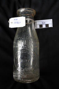 City of Moorabbin Historical Society (Operating the Box Cottage Museum)
Manufactured Glass, milk bottle 'Black Rock Dairy', 20thC
Alfred R Varcoe was a dairyman with stables, cart shed and his house in Eliza Street, Black Rock, Victoria. Dairy farming was established early in the settlement of the Brighton / Moorabbin area following the Dendy's Special Survey 1841 and subsequent land sales c1850. The produce was taken to feed the population of Melbourne and local residents.A clear glass ,1 pint , milk bottle used by Black Rock Dairy, MelbourneTHIS BOTTLE CONTAINS/ MILK / BOTTLED FOR SALE BY / BLACK ROCK MODEL / DAIRY / BLACK ROCK / BOTTLE IS THE PROPERTY OF THE ABOVE / IT IS OWNED AND CANNOT BE LEGALLY USED BY OTHERS/ ONE IMPERIAL PINT on base 440market gardeners, early settlers, farmers, dairies, milk production, moorabbin shire, moorabbin, cheltenham, black rock, brighton, dairy farmers, bottles, glass manufacture, varcoe alfred r; black rock dairy, dairy farmer, dairy products sales and deliveries, -
Glenelg Shire Council Cultural Collection
Souvenir - Souvenir Envelope, 1984
Two Australia Post souvenir envelopes - Victoria's 150th anniversary (Portland. First settlement). Cream coloured, envelope, full colour design on front of envelope shows Edward Henty, view of township, thistle, pier and council logos. Reverse has shows 150th.australia post, souvenir, victoria 150th -
Glenelg Shire Council Cultural Collection
Medal - Medallion, 1934
3 brass medallions, ring at top, threaded with red, white and blue ribbon. 100th Anniversary of first settlement at Portland 1834 - 1934. Edward Henty on one side, Lt. Grant and the 'Lady Nelson' on the other.commemoration, medal, 1834 to 1934, henty -
Glenelg Shire Council Cultural Collection
Souvenir - Envelope - Centenary of Portland celebrations 1934, c. 1934
Envelope, cream, blue bordered rectangle in left side of envelope with blue print 'Centenary of Portland celebrations. The State's first settlement 19 November 1934' -
Glenelg Shire Council Cultural Collection
Souvenir - Envelope - Centenary of Portland Celebrations issue 1934, Nov-34
Centenary of Portland 1934Envelope, white, Centenary of Portland Celebrations issue. Blue print, left hand side of envelope 'CENTENARY OF PORTLAND THE STATE'S FIRST SETTLEMENT 19 NOV. 1934 CELEBRATIONS' -
Glenelg Shire Council Cultural Collection
Souvenir - Souvenir - Sticker Portland 150th, 1984
Glenelg Shire Council Records dept.Oblong-shaped promotional sticker, promoting Portland's 150th celebrations in 1984. Black text printed on white background, plus logo of whale in triangle with blue green wave designs.Front: Portland's 150th Anniversary, 1934 1984, Victoria's First Permanent Settlement -
Glenelg Shire Council Cultural Collection
Souvenir - Cloth Badge - Portland souvenir, n.d
Cloth badge, white, rectangular, 'Portland's 150th Anniversary' logo. Royal blue blanket stitch around borders. Grey felt backing.Front: 'PORTLAND'S' - above logo '1834-1934' - either side of logo '150th ANNIVERSARY VICTORIA'S FIRST PERMANENT SETTLEMENT' - beneath logo -
Glenelg Shire Council Cultural Collection
Souvenir - Spoon - Portland Souvenir, n.d
Spoon, silver plated, badge with Portland's 150th logo; 'Portland's" above logo; "1834 1984' either side; '150th Anniversary Victoria's First Permanent Settlement' beneath logo.Back: 'Collector's World EPAI' - impressed -
Glenelg Shire Council Cultural Collection
Souvenir - Glass, c. 1984
Small, clear glass, Portland's 150th logo embossed in gold. Story of Portland's settlement on back of glass, gold, embossed. Gold rim.Front: 'Portland's - above logo, 150th Anniversary, 1984' - below logo gold, embossed -
Glenelg Shire Council Cultural Collection
Souvenir - Plate - Portland 150th Anniversary, c. 1984
White, fine china Westminster plate, commemorating Portland's 150th Anniversary. 150th logo in centre. Black print surrounding, gold rim.Front: 'PORTLAND'S 150TH ANNIVERSARY 1834-1984 VICTORIA'S FIRST PERMANENT SETTLEMENT' Back: Maker's mark: 'FINE CHINA WESTMINSTER AUSTRALIA'souvenir of portland, 150th anniversary, plate, commemorative -
Glenelg Shire Council Cultural Collection
Souvenir - Spoon - Portland 150th Anniversary, n.d
Silver plated spoon, badge with Portland's 150th logo, with 'Portland's' above logo; '1834 1984' either side of logo; '150th ANNIVERSARY VICTORIA'S FIRST PERMANENT SETTLEMENT' beneath logo.Back: 'Silverplated' - impressed 'Celest Perfection Plate Pty Ltd Australia' - impressedsouvenir of portland, teaspoon, 150th anniversary -
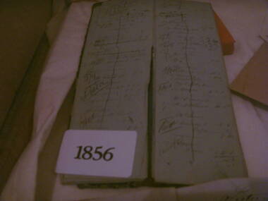 Heathcote McIvor Historical Society
Day Book, Book, 1856
Believed to be long to Routledge Brothers who ran a general store business in heathcote. They also owned a sawmill and quartz crushing battery.one of three books donated to the Museum, were found by the donors father back in the late 1960's while he was working on renovations to a building in heathcote these books had been thrown onto a pile of builders rubble, he retrieved them. when he passed away some years later his son found them while clearing out his effects, have travel through several house changes till 2010 when the son was doing a cleanup and the books were found again he contacted the Historic Society, date back to first settlement of Heathcote, inside writing is in excellient condition, as if it were written yeaterday. give a daily account of purchases by locals.gives us an insight into persons living and working in Heathcote McIvor district. Not many early items of this era left .Day book, oblong, leather cover, Day book gold blocked on front coverday book routledge, brothers -
 Eltham District Historical Society Inc
Photograph, Hurstbridge shops, Heidelberg-Kinglake Road, opposite Hurstbridge Railway Station, Eltham Heritage Tour, 24 May 1992, 24/05/1992
ELTHAM HERITAGE TOUR The Society excursion on 24th May 1992 was arranged by David Bick, leader of the team carrying out the Shire's heritage study. David selected a number of sites or buildings identified in the study, some of them lesser known components of the Shire's heritage. The tour commenced at the Eltham Shire Office at 10.00 am. Travel was by private car and mini-bus with stops at about twelve locations for commentary by David.It included a short walk in Hurstbridge and lunch at Kinglake. Highlights of the tour included: - 10 am Leave from Shire Offices - 3 Important Trees - A Physical Link to Eltham's First Settlers - Toorak Mansion Gates - A Surviving Farm House - An Intact Circa 1900 Main Street - First Settlers - Gold Miners, and Timber-getters - An Early Hotel - A Pioneering Homestead - Changing Eltham Shire - 20th Century - 4 pm Afternoon Tea and Finish Tour Extract from ELTHAM CULTURAL HERITAGE TOUR (Newsletter No. 85, July 1992, by Bettina Woodburn) "Leaving the cars at Hurstbridge we walked the main street of the old village settlement, now a suburb. Near the station was a fine Edwardian house complete with palm and pines. Opposite was the Police Station, 1930-60 with a portable lock-up behind and the residence beside it. No. 794 was the Post Off1ce 3099 the-original shop-front window now has mail-boxes below. Close to the Railway entrance the butcher's shop remains unchanged, but across the road the linear shopping centre tries to keep the character of the olden times. The Fire Bell once hung on a tall gum outside No. 832. Palms in front gardens indicate the age of some of the homes, about 70 years. A corrugated iron shed still stands on the front fence line next to No. 840. Adding to the streetscape is an example of the standard timber early 20th century four veranda post suburban villa."Record of the Society's history and activities and highlighting various aspects of the Heritage Study undertaken by David Bick used to create the future heritage overlay for the Shire of Eltham and later Nillumbik Shire.Roll of 35mm colour negative film, 4 stripsKodak Gold 100 5095shire of eltham historical society, activities, heritage tour, hurstbridge, shops -
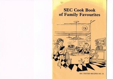 Kiewa Valley Historical Society
Book - Reference Cooking, SEC Cook Book of Family Favourites, Circa 1950
This SEC cook book was produced circa 1950s when the Kiewa Hydro Electricity Scheme and its Commission was in full swing. The Commission had constructed two settlements, Mount Beauty and Bogong Village to house construction workers and their families in a "closed" community. These "closed" communities were for SEC staff and construction workers only. Entry into these villages was restricted to "SEC pass" carrying construction staff and their families. All facilities such as retail, sporting and other community services was provided by the SEC. This created an isolated community in which limited individual choice or administrative family leeway was available. It was a typical company town (live and work for the company). The Company was in the Kiewa Valley constructing power stations for the Kiewa Hydro Electricity Scheme of Victoria. In one way the individual did not need to be concerned with living costs, educational needs for children, and recreational amenities and therefore "normal" community survival /living methods did not apply. This living, although restrictive, was quite simple. When the scheme was completed, in 1961, marking the end of company town, caused some of the employees, who had enjoyed the "controlled" township environment, a fair degree of angst in having the new 'laissez-faire" controls thrust upon them. This was magnified when both Mount Beauty and Bogong Village became meshed into the Bright Shire, vis-a-vis, local government. This cook book is a prime example of " the company is looking after you" and leave the worrying to us. This environment of a "company town", which creates the atmosphere of minimal personal responsibilities, is still present in a few remote mining towns in Australia at the beginning of the 21st Century.This book is a classical example of the psychological control in which the company had its construction workers families living in. The motto of many companies who had employees in isolated regions was "keep them happy". A happy and contented worker is a more productive worker. This was a period in time (1950s to 1970s) when social psychology was gaining recognition in the Australian workforce as well as internationally. At the end of the construction of all the power stations both the Mount Beauty settlement and the Bogong Village became more integrated into the main stream of rural Australia environment. Development of tourism in the region opened up not only interaction with a greater cross section of the ever expanding type of Australian but also the overseas based non rural culture tourist or immigrant. It allowed the intermingling of ideas in a non company controlled environment. The Mount Beauty and Bogong Village has, and even up to the 3000 Millennium, the same housing construction, as was built by the SEC. There has only been a very gradual change to modern domestic architectural home styles. This SEC cookbook has a folded cover with two staples at the spine, securing eight double sided pages. The white pages contain black print and sketches(3), and one black and white photograph (of the author). The front cover is mainly orange in colour with a gradual fading into yellow(at the top). The cover is approximately 210 g/m2 in thickness and each page is approximately 90 g/m2 thick. Front cover: top of page "SEC Cook Book of Family Favourites", in the middle a sketch, black on orange background, of a smiling mother walking from the kitchen to the dining table with a steaming rolled roast and vegetables in one hand and a gravy pot in the other. The furniture and decor relates to the 1950s. Below this sketch is printed"SEC TESTED RECIPES NO. 16" Inside cover: on top of the page is a black and white sketch of a pineapple, apple pear fish with scales, bunch of grapes with leaves a pork roll (head of pig one end and a roll ending on the other, on top of this food arrangement rests a fruit pie. Below this sketch are printed in black print the books contents.The first side of the first page is a black and white photograph Mary Dunne, the SEC Home Service supervisor who provided a signed foreword. The inside back cover has a promotional segment detailing a black and white photograph of a smiling (and happy) couple in the foreground with an electric stove in the distance. The written motto below this photograph is" to Live better -and save money they'll join the Power People. "the new tariff is(1960s) - First 75kWh --6 cents per kWh Next 435 kWh---2.3 cents per kWh Balance --1.7 cents per kWh The rate per killowatt-hour for the final block drops from 2.1 cents to 1.7 cents --a reduction of 19%.cooking recipes circa 1950s, domestic food, sec victoria cook books, recipes circa 1950s -
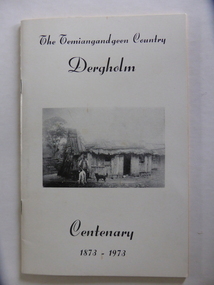 Warrnambool and District Historical Society Inc.
Booklet, The Temiangandeen Country Dergholm, 1973
This booklet gives information on the settlement of Dergholm at the time of the centenary of its founding, 1973. The origin of the name Dergholm is unclear but it may have Irish connections. Europeans came to the area in the 1840s and 50s but it was not until the 1870s that the town was surveyed. Dergholm is in the far west of Victoria 334 kilometres from Melbourne and nearby is Dergholm State Park established in 1982. The booklet was produced for the Centenary Back to Dergholm Committee and the local centenary celebrations. This book is of some interest as it provides information on Dergholm, a settlement in the far west of Western Victoria. This is a soft cover booklet of 52 pages by Alistair Roper. It has a cream-coloured cover with a black and white photograph of early Dergholm on the front cover (Edward Quinn’s house). The booklet has printed material - a President’s Message, an Author’s Note, Acknowledgements, Contents, information on the Dergholm area, including a list of local birds, and References. There are several black and white photographs of the area and its people. The book is stapled. Front Cover: ‘The Temiangandgeen Country, Dergholm Centenary, 1873-1973’dergholm victoria, alistair roper, history of western district of victoria -
 Warrnambool and District Historical Society Inc.
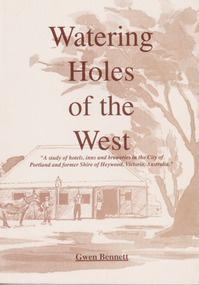
Book - Book: Watering Holes of the West, Watering Holes of the West, Published 1997
A study of hotels, inns and breweries in the city of Portland and the former shire of Heywood, Victoria.Sepia coloured soft card cover with drawing of an inn with people and coach outside. Drawing is identified as the Halfway House Tyrendarra from a photo courtesy of Miss J Brownlaw with artist Pam Sillard. Title in brown text. Author’s name in brown text at bottom of front cover. 112 pages with 22 chapters and index at the back.non-fictionA study of hotels, inns and breweries in the city of Portland and the former shire of Heywood, Victoria. watering holes, portland, shire of heywood, pubs, hotels, inns, breweries -
 RSL Victoria - Anzac House Reference Library and Memorabilia Collection
Photograph, Macleod Repatriation Sanitorium, circa 1914
The former Mont Park/Bundoora Psychiatric and Repatriation Hospitals Complex consisted of seven hospitals on a site of 185 hectares. The site comprising the Mont Park and Strathallen estates was consolidated by the Victorian government by purchase and transfer from the Closer Settlement Board in 1909 . The Mont Park Hospital commenced in 1910 with the building of the Farm Workers Block . In 1912 the landscape gardener Hugh Linaker was employed to layout the grounds of Mont Park and other State mental hospitals. The other hospitals were gradually split off from the Mont Park administration to form separate entities included among these was the Macleod Repatriation Hospital (1915), An agreement was made with the Defence Department in 1914 for the latter to erect the Mont Park central block (the "Chronic Wards") for use as a Military Hospital, and for it later to revert to the State as portion of Mont Park Hospital. The buildings now known as the Chronic Wards were completed in this way in 1916 and used as the Australian General Hospital no. 16 for the duration of the war. One wing of this building was set aside for mental patients during this period. Silver gelatin photographww1, macleod repatriation sanitorium, mont park