Showing 177 items
matching stone bridges
-
 Ballarat Tramway Museum
Slide - 35mm slide/s - set of 4, Dave Simpson, late 1960's early 1970's
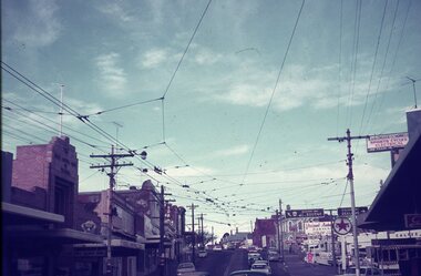
... of Stones Corner, corner of Bridge St, Victoria St and Main Road... Stones Corner and the traffic situation in Bridge St. Tramways ...Yields information about Stones Corner and the traffic situation in Bridge St.Set of four 35mm slides - Anscochrome white plastic mounts of Stones Corner, corner of Bridge St, Victoria St and Main Road. .1 - shows the overhead arrangements, with a tram about to enter Bridge St from Main Road. Has the Caltex service station in the background, also advert or roof signs for Viscount Ambassador Caravans, K&O (Digger) Schonell Sports Cycles and Electrical store. .2 - No. 26 inbound with many passengers - showing Mt Pleasant - could be running a Special. .3 - ditto with many cars in the photograph. .4 - tram 39 about to enter Bridge St from Main Road - has a red letter box on corner.tramways, trams, main road, bridge st, victoria st, stones corner, tram 26, tram 39 -
 Bacchus Marsh & District Historical Society
Photograph, Home and surgery of Doctor Rae, Bacchus Marsh 1883
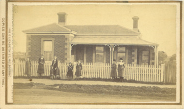
... and girls. A flat stone acts as a bridge over a deep drainage... and girls. A flat stone acts as a bridge over a deep drainage ...This image is one of a series of photographs taken by Melbourne based photographers Stevenson and McNicoll who visited Bacchus Marsh and its nearby districts between September and November 1883. The photo is of a brick residence, built in 1865-66 as a house and surgery for Dr. Rae, a medical practitioner in Bacchus Marsh 1863-1874. Dr. Rae was influential in community affairs as a Justice of the Peace, a member of the Board of Advice of Bacchus Marsh Common School and a President of the Mechanics’ Institute. After ill health forced him to resign his practice, he built the Bungalow in 1880, where he lived until his death. The house was later purchased by William Anderson (c.1880) who named it “Dunglass”. The people in this photograph are probably members of the Anderson family. The house is now used as an Adult Education Centre. The house is of significance as the embodiment of the importance to the community of its influential figures, such as Dr. Rae, in the late nineteenth and early twentieth centuries. Small sepia 'carte de viste' style unframed photograph on card with gold border framing photograph. Housed in the Jeremeas Family Album which contains photographs of Bacchus Marsh and District in 1883 by the photographers Stevenson and McNicoll. The photo is of a double-fronted brick Classical nineteenth century house with a high hip roof. Two brick chimneys are visible. The left hand bay is set forward, with the central section of the house being set back. A concave return verandah supported by decorative columns runs along the front and side of the house, leading to a separate entry door off the side verandah. On the window set in this door, the word ‘SURGERY’ can be discerned, indicating that this is the entrance to be used by patients. The building features buff-coloured stone quoins and architraves. A white picket fence runs along the front. Ranged along the footpath in front of the fence stands a group of eight young women and girls. A flat stone acts as a bridge over a deep drainage culvert running parallel to the street.Printed On the front: Stevenson & McNicoll. Photo. 108 Elizabeth St. Melbourne. COPIES CAN BE OBTAINED AT ANY TIME. On the back: LIGHT & TRUTH inscribed on a banner surmounted by a representation of the rising sun. Copies of this Portrait can be had at any time by sending the Name and Post Office Money Order or Stamps for the amount of order to STEVENSON & McNICOLL LATE BENSON & STEVENSON, Photographers. 108 Elizabeth Street, MELBOURNE. stevenson and mcnicoll 1883 photographs of bacchus marsh and district, doctors, houses bacchus marsh -
 Kew Historical Society Inc
Photograph, Opening Ceremony Victoria Street Bridge: Laying of memorial stone by John Adam Esq. Mayor of Richmond, 1884
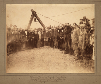
... Opening Ceremony Victoria Street Bridge: Laying of memorial... that: ‘The ceremony of laying the memorial stone of the Victoria-bridge, which... that: ‘The ceremony of laying the memorial stone of the Victoria-bridge, which ...A formal group photograph of the grand opening of the Victoria Street Bridge on March 31 1884. The Argus was to report that: ‘The ceremony of laying the memorial stone of the Victoria-bridge, which connects Kew and Hawthorn with Richmond and Collingwood, was performed yesterday afternoon by the mayor of Richmond (Mr John Adam) in the presence of a large assemblage. Among the gentlemen present at yesterday’s proceedings were the mayor of Collingwood (Mr. M. Dwyer), the Mayor of Melbourne (Councillor C. Smith, M.L. A.) the mayor of Kew (Mr. Barnard), Mr. J. A. B. Koch and Mr. W. W. Shelley (ex mayors of Richmond), Mr. Joseph Bosisto, M.L.A., the Hon. L. L. Smith, Councillor De Mole (ex mayor of Kew), Mr. Jas. Lancashire and Mr. Winter (ex mayors of Ricmond), Mr. Walker (ex mayors of Collingwood), Mr. Johnson (engineer), Mr. C. Rowan, C.E. (engineer of the bridge alterations) and the town clerks of Richmond, Collingwood and Kew.’ Following the opening ceremony ‘… a ponderous steam roller was driven over the structure, with a view to test, or rather to demonstrate its stability … Most of the gentlemen present walked over the bridge, after which they were grouped by a photographer, with the memorial stone as a central feature, and several views of the scene were taken’.An original, rare silver albumen mounted and titled photograph of an important event in 19th century Melbourne.Original photograph mounted on display card of the opening of the Victoria Street Bridge. The original photograph is very faded and has been enhanced to improve the image's viewability.On the reverse of the card is an indecipherable stamp and an inscription identifying the photographers. "T. W. & C. A. McAlpine Bros, Photographers &., Campbell Parade East Richmond Melbourne March 31.1884victoria street bridge, john adam, m. dwyer, c. smith, barnard, j.a.b. koch, w.w. shelley, bridge, kew, collingwood, l.l. smith, joseph bosisto -
 Ballarat Tramway Museum
Film - Movie Film & Box, Kodak, 1960
... 13, showing “View Point” at Stones Corner, Bridge St, east... 1960, Part 1” 0:16 13, showing “View Point” at Stones Corner ...Yields information in movie film format of Ballarat trams in 1960, how the system operated and was used by people., Yields information in movie film format of Ballarat trams in 1960, how the system operated and was used by people.Movie film - 8mm, approx. 30mins, with leader strip on a plastic reel, within a black and white plastic box, titled "Ballarat No. 1. 1960". Has been transferred to DVD - see Reg item 4100 as Segment No. 2. Made by Ben Parle. Also transferred to DVD by Rod Cook Oct. 2015, via Roger Greenwood for use in his DVD, "The City of Ballarat Trams, Gardens & Gold" of 2016. See Reg Item 6883. Synopsis: based on time. 0:00 View of typed introduction, noting that this is a pictorial record of Ballarat. 0:10 Title “The Tramways of Ballarat 1960, Part 1” 0:16 13, showing “View Point” at Stones Corner, Bridge St, east end, with trolley pole being turned, while another single trucker heads out towards Mt Pleasant. 0:25 13 leaving Stones Corner, short approach and then longer trailing shot of the tram going towards the City in Bridge St. 0:44 View out of front of tram in Bridge St heading towards the City, with cars in the photo, then passing through city Loop, no trams in the loop and running up to Lydiard St Nth and crossing the road. 1:22 Running up Sturt St from Armstrong St, passes over Dawson St X-over and up to the next intersection, Lyons St. 1:54 Title “The View Point Line” 1:59 19 inbound, in Ripon St, from crossing Mair St, towards camera and then passing away and turning into Sturt St. 2:49 View of a “Warning Oncoming Trams” sign 2:52 19 in Ripon St, going to View Point, crossing Webster St towards camera, then going away through the disconnected Victoria Ave loop, pass the “Warning Oncoming Trams” sign. Note very windy scene with people running across roads. 3:17 19 in Wendouree Parade, in bound, though showing destination View Point, going away from the camera, past the View Point Hotel. 3:39 19 coming towards camera near Excerpt or Devon St and then going away towards the terminus. 4:04 19 at the terminus, stationary, with a single trucker 3?, passing from Macarthur St into Wendouree Parade, behind 19. 4:20 33 coming towards camera in Wendouree Parade from St Aidans Drive, stopping to pick up passenger at Forest St and then going away towards the City, photographed from near the depot, on a wet and windy day. 4:54 35 in Wendouree Parade, coming towards the Camera from St Aidans Drive and then going away with the Gardens Loop area in the background. Tram stops at stop to let a passenger off. 5:28 21 leaving Gardens Loop for the City via the Depot, green light in signal can be seen. 5:43 28?, closely followed by 26 turn from Drummond St South into Sturt St. 6:18 Scene opens with shot of “Sebastopol” destination on a bogie tram. 6:21 Title “The Sebastopol Line” 6:24 21 turning from Sturt St into Drummond St Sth with destination of Bell St and then going away from the camera. 6:55 38 in Drummond St Sth, coming towards the camera and then passing the camera with Sturt St just in the view. 7:10 21, showing Gregory St, in Drummond St Sth, approaching and then going away, entering the Urquhart St Loop, 7:39 34 in Drummond St Sth (location check required (Latrobe?)), approaches camera, picks up passengers and the goes away. 8:09 39 at ? Street, turns from Drummond St Sth into Skipton St, after picking up and setting down passengers, bound for Sebastopol 8:55 35 inbound in Skipton St passes through the Bell Street Loop, and then goes away from the camera. 9:33 42 outbound in Skipton St, approaches the camera, passes and then crosses over the half the road into Albert St. 10:00 39 inbound in Albert St – location? 10:31 34 outbound for Sebastopol, approaches camera and just starts to pass by. 10:36 34 in Grey St crossing loop, crosses 42 inbound. 10:59 39 outbound in Albert St, with shopping centre in bound, approaches camera, passes and then crosses over Albert St. Mid morning scene. 11:39 39 inbound, Albert St south, approaches camera and then passes and the crosses over Albert St. 12:16 41 outbound in Albert St passes the camera, and pulls into the terminus with the conductor getting out on the back bumper to pull the pole down as the tram stops and a passenger walks into the Royal Hotel. 12:39 Title “The Lydiard Street North Line” 12:44 Filmed from the Hotel balcony, 21 inbound in Lydiard St Nth passes over Mair St, stops while 33 passes in the other direction. 13:18 With the red light showing on the Seymour St loop signal, 33 inbound for Sebastopol stops and picks up many passengers, passes the camera and runs past the VRI building in the background and through the loop. Possibly filmed on a Sunday given the ladies dresses and quieter streets. 14:01 30 outbound, passes the camera and stops at Macarthur St. Filmed alongside the brick wall of the cutting. 14:28 30 inbound arrives, passes through the Gregory St loop and then proceeds past the camera, making a stop to pick up passengers. 15:14 28 in Lydiard St Nth – location?, approaches and goes away from the camera, north of Gregory St. 15:34 28 ditto location? 15:53 21 arrives at the terminus with passengers getting on and off. 16:11 View of the a vertical positioned “End of Section” sign on a pole at the terminus and then lifting the camera to see the timetable board and the stop sign. 16:33 31 in Bridge St passing Morseheads and then turning into Sturt St, stops at the Grenville St stop, while another single trucker comes down to the stop from the City. 16:58 31 outbound in Bridge St, with destination of Victoria St. 17:14 Title “The Victoria Street Line” 17:18 31 outbound to Victoria St from Stones Corner. Starts with an overhead shot, shows clock at the Caltex service station,. 17:37 31 inbound approaching Bakery Hill and then descending to the junction after it passes camera. 18:09 25 climbing outbound in Victoria St, passing the camera, to then pass through the King St loop. 18:47 25 inbound in Victoria St, passing the camera, then pass through the King St loop, with St Alypius Church in the background. 19:36 14 approaching the rail bridge in Victoria St and stopping at the 2nd last stop to left of passengers. 20:01 14 leaving the terminus and approaching the camera and the a short sequence going away, to the next stop to pick up quite a few passengers. 20:14 “Trams Stop Here” sign, metal wrap around on a steel pole. 20:16 Title “The Mount Pleasant Line” 20:21 11 inbound in Main St, with a passenger leaping off the tramcar and another getting off just before the junction. 20:45 11 passes the junction and then proceeds away from the camera in Bridge St. 21:04 30 outbound in Main St, then turns into Barkly St, a bus (Eclipse Motors) passes in Main St just before the sequence ends. 21:31 30 inbound near Steinfield St. (exact location?) 21:49 25 approaches the camera, then proceeds away and passes through the Grant St. loop. 22:29 25 inbound, windy day, between Grant and Cobden, (exact location?), with a horse drawn bread van in the view and the breadman walking behind the tram as it passes. 23:02 11 outbound in Barkly St, (exact location?) 23:37 11 inbound in Barkly St (exact location?) 23:44 Mt Pleasant terminus signage 23:50 30 approaches the terminus and then stops with the conductor alighting turning the pole, passengers getting on and off and the driver appearing at the other end. 24:32 Title “The Gardens Via Sturt St. West Line” 24:35 21 outbound in Sturt St near Raglan St, approaches and passes the Camera. 25:09 12, showing City Oval, approaches and passes the camera, outbound near Windermere St. 25:33 13 showing View Point, goes away from the camera – location? 25:44 12 comes from St. West, inbound passes the camera and then stop as the next stop next Talbot St? 26:21 Short sequence of a “Warning Oncoming Trams” sign 26:28 42 inbound in Sturt St West, just before Ripon St, view coming towards camera and then going away to cross Ripon St. 27:10 34 passes through the Parker St loop 27:25 35 or 39 inbound past the college in Sturt St West 28:04 41 outbound at the Russell St curve, passes away from the camera. 28:11 35? inbound passes away from the camera through the Victoria Park or Morrison St loop, swinging out into the roadway. 28:29 View of timetable sign at Hamilton Ave. 28:37 35 turning from Sturt St West into Hamilton Ave, can see the conductor changing over the barrier rails. 29:11 42 inbound, crosses another bogie tram (35?) at Carlton St loop then passes the camera and goes past the Olympic rings monument. 29:42 12 approaches the Carlton St gates. 30:07 12 outbound, crosses a bogie tram in the loop with both trams then leaving the loop. 30:20 Title “End of Part One” Written labels giving title information on outside of box.trams, tramways, ballarat, sebastopol, lydiard st north, victoria st, mt pleasant, sturt st west -
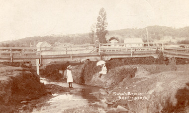 The Beechworth Burke Museum
Postcard, c. Early 1900s
Taken in the early 1900s, the postcard depicts two girls dressed in old style, white knee length dress which was common for this period for young women. This compared to the ankle length styles which were acceptable for adult women. We can also see an example of early bridge construction and engineering, notably made from timber rather than from stone or steel, noted in the postcard as Snow's Bridge. Sepia rectangular postcard printed on card Obverse: Snow's Bridge/Beechworth Reverse: Dear Julie/ I received your pretty PB/ We haven't gone away yet. Mr Stokes/ asked me were you going to be/ married. He wished you luck/ (I wonder/ if he meant it.) We sent the Magpie to Annie to-day. I haven't got any/ word about going to a [unknown]/ yet. We had a great Friendly Societies/ day yesterday but it rained a bit/ Sally is going to get a [illegible] silk/ dress. When are you to be married?/ Mr Pounceby is back at Allen's shop./ [unknown]. We are going to Belle's for a [unknown] if we can. With Love from Lilly. bridge, beechworth, snow's bridge, children, childhood, postcard -
 The Beechworth Burke Museum
Geological specimen - Feldspathic Sandstone
Feldspathic arenites are sandstones that contain less than 90% quartz, and more feldspar than unstable lithic fragments, and minor accessory minerals.Feldspathic sandstones are commonly immature or sub-mature.These sandstones occur in association with cratonic or stable shelf settings. Feldspathic sandstones are derived from granitic-type, primary crystalline, rocks. If the sandstone is dominantly plagioclase, then it is igneous in origin Sandstone features prominently in public buildings throughout Victoria. Most of the sandstone used as dimension stone in the State came from three sources: the Heatherlie quarry in the Grampians (Silurian), the Bacchus Marsh area (Permian), and the Barrabool Hills near Geelong (Cretaceous).Sandstone features prominently in public buildings throughout Victoria, making this specimen special as it shows the materials used by Victorian building companies. Sandstone can also be crushed, crushed stone is used in the construction of roadways and road structures such as bridges, and in buildings, both commercial and residential. This specimen is part of a larger collection of geological and mineral specimens collected from around Australia (and some parts of the world) and donated to the Burke Museum between 1868-1880. A large percentage of these specimens were collected in Victoria as part of the Geological Survey of Victoria that begun in 1852 (in response to the Gold Rush) to study and map the geology of Victoria. Collecting geological specimens was an important part of mapping and understanding the scientific makeup of the earth. Many of these specimens were sent to research and collecting organisations across Australia, including the Burke Museum, to educate and encourage further study. A feldspar-rich sandstone, a sandstone intermediate in composition between an arkosic sandstone and a quartz sandstone, containing 10% to 25% feldspar and less than 20% matrix material of clay, sericite, and chlorite. Feldspathic arenite containing less than 90 percent of the composition of quartz. Feldspar is the main composition. Feldspathic arenite may contain fragments of unstable rock, and a little amount of other minerals such as mica and heavy minerals. Some feldspathic arenite have pink or red color because of the presence of potassium feldspar or iron oxide. There are also colored light gray to white. These sandstones are usually medium to coarse grained and can contain a high percentage of granules with angular until subangular roundness. The content of the matrix can appear as the rest up to more than 15 percent, and sorting of grains can present as moderate to poorly sorted. Feldspathic sandstones are generally immature in textural maturity. Feldspathic arenite can not be judged from the structure of the sediment. Bedding can emerge from the laminate parallel to the crossbed. Fossils may appear in the layer deposited on the sea. Feldspathic arenites usually appear on the craton or the continental shelf, which can be associated with conglomerate, quartz lithic arenite, carbonate rock, or evaporites. This sandstone may also appear on the succession of sedimentary basins deposited on an unstable or deep sea, and moving arc setting. According to Pettijohn (1963) Arkose make up about 15 percent of all sandstones. Some Arkose formed in situ when the granite and related rocks disintegrate and generate granular sediments. Most of the material feldspathic sandstones derived from primary crystalline granitic rocks, such as granite or metasomatic rocks containing abundant potassium feldspar. Mineral contained in sandstones is mostly a form of plagioclase feldspar derived from quartz diorite or volcanic rock. Feldspar contained on this sandstone comes from arid to cool climates when the chemical weathering process is reduced.sandstone, natural stone, feldspathic sandstone, burke museum, geology, geological, geological specimen -
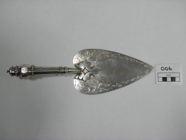 Ballarat Fire Brigade
Trowel, just prior to 01/01/1864
Trowel was presented to Captain Spark by honourable secretary Mr Charles Dyte on 1/1/1864 to lay the foundation stone of the watchtower and belfrey of the Ballarat fire station. Trowel was made by Mr. Bennett of Bridge street and fashioned on the trowel used by Mr. Fraser M.L.C. when laying the foundation stone of the St. Kilda town hallhand engraved sterling silver ceremonial trowel. engraving is floral design on blade. handle is hollow, octaganol with leaf pattern and greek meander patternHallmarked on underside - emu, "WE" (letters), kangarooballarat fire brigade, captain, foundation stone, trowel, colonial silversmith, silver trowel, captain spark, honourable secretary, mr bennet, sterling silver, charles dyte, dyte, spark, 1864, watchtower and belfrey, tower, watchtower, belfrey -
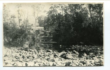 Orbost & District Historical Society
black and white photograph, April 17, 1897
This is the Nowa Nowa crossing off Old Orbost Road, to the first Nowa Nowa Hotel built by Moses Faithfull, in 1890, in background. Moses Faithful came to Australia from England with his parents on the Royal Consort in 1844. After living at Bulla, Pakenham and Wurruk he and his wife moved to Hospital Creek in about 1885 where he took up the first selection of land at Upper Hospital Creek. As well as farming he built the first hotel at Nowa Nowa in 1890. He had charge of the hotel until 1895 when he sold to Mary Stirling. Moses died on 8th July 1901, aged 66, at the residence of his son-in-law, David Price, at Newmerella, and buried in the Orbost cemetery.This hotel was built in 1890 and doubled as a coaching stop on the inland route. Settlement grew up around the hotel. It was sold 1895 to Mary Stirling who husband own the land the hotel stood on. The hotel burned down on 29 July 1955. This is a pictorial record of Nowa Nowa in the late 19th century.A black / white photograph of a creek crossing with large stones in the foreground. A bridge can be seen in the background across the creek.nowa-nowa faithful-moses stirling-hotel -
 Eltham District Historical Society Inc
Film - Video (VHS), Diamond Creek Fire Brigade, c.1955-1987
... . In the meantime, Captain Clarrie Stone and Fireman Shaw undertake some.... In the meantime, Captain Clarrie Stone and Fireman Shaw undertake some ...Combination of three movie films. Movie One (1950s): 00:00 – 13:14 Black and white footage of Diamond Creek firemen practising in Diamond Street in the 1950s for forthcoming demonstrations of abilities. Mentions of Gordon Brandy and Joe Hislop Running out hoses from old hose reels along Diamond Street, Diamond Creek Displays from various brigades running out and connecting hoses. Also scenes from the 1950s of Diamond Creek Fire Brigade competing in various locations around Victoria and Tasmania. Mentions of Brigade members Dave Kidd, Bruce Hackett, Ron Kirkbride, Jack Marks, Graham Upton who are prominent in these events. Members of Kyneton Fire Brigade also present. Members competing in running out hose reels, connecting hoses togethers and to hydrants then climbing towers to direct water from hose or at a target hanging above the road. Diamond Creek members identified wearing a diamond on their chest and back. Includes scenes of Scottish pipe bands at the events and significant crowds of spectators. Footage of Mel Stone and Beryl Marks, Stan Redpath and Ron Kirkbride, then Ron Kirkbride and Eric Holt viewing flower displays. Film changes to colour at Diamond Creek oval for practice with fire engine entering oval. Members depicted include Bill May, Jack Sinclair, Jim Cox, Bob Beale, Dave Kidd, Bruce Hackett and Captain Clarrie Stone. Reverts to black and white in the 1950s where the Brigade joins forces with the Diamond Valley Community Hospital for a Gala Day on the Diamond Creek Oval. Changes to colour again, possibly same event and scenes of children on bikes and scooters or with prams and carts racing around the oval. Mention of young lad Brian Laurie who has his own fire truck. Dart throwing, pony rides. Scenes with Dr Don Cordner, Gus Lyons, Vic Cohn (?) and spinning wheel and Diamond Creek School children entertain a large crowd with Maypole dancing. Movie Two (1950s): 13:25 – 19:00 This black and white film was taken by a TV film crew in the 1950s depicts a typical call out for the Diamond Creek Fire Brigade. In this case the careless action of a member of the public throwing a lighted match from a car, which can cause extensive damage. Footage features the Shire of Eltham War Memorial tower at Kangaroo Ground before it was modified with a fire spotter’s cabin. Discusses fire spotting operations from the tower. Shows a fire spotter walking around the top of the tower. A fire is detected, and the information is relayed to the nearest fire station, in this case, Diamond Creek. The telephone call is received, and the alarm sounded. Captain Clarrie Stone and firemen May and Shaw leave their workplaces and prepare for action. Scenes of running across the Main Hurstbridge road showing the shops (Shell service station and Chemist prominent). Scenes entering the fire station which has a pictorial warning covering the entire door “Only you can prevent forest fires – If you’re careless – we’re homeless!” Eric Holt pinpoints the location of the fire while Captain Clarrie Stone and Fireman Shaw take note. The advance vehicle (an FE Holden ute, rego GTE-696) leaves to assess the extent of the fire. Having assessed the fire, Fireman Shaw communicates with base showing radio with call sign VL3JZ. Eric Holt takes the call. In the meantime, Captain Clarrie Stone and Fireman Shaw undertake some limited action to address the fire. Firemen Bill May, Jim Bates and Hugh Bar (?) man the tanker. A photo portrait of Queen Elizabeth is visible hanging on the wall. They are later joined by Firemen Jim Cox, Eric DeBuse (?) and Jack Marks. The tanker is seen departing the station and diverging off before the bridge. Captain Clarrie Stone and Fireman Shaw are seen pumping water on the flames with hand pumps when the tanker arrives. The hose is unreeled, and water turned on the flames. Jack Sinclair joins the action. Jim Cox directs water to the high stuff. The fire put out, Jack Marks and Eric DeBuse wind in the hoses and the team head back to town. It’s peaceful again at the memorial tower. Movie Three (1969-1987): 19:14 – 34:34 Colour film “Fired with Dedication”, Country Fire Authority Victoria, produced by I.L. Wadeson, Commentary by A.M. Hem. Credits with CFA Victoria emblem and then placed over a view of an old-style ladder engine. Opens with the scene of a fire engine outside the Diamond Creek Fire Station then various trophies reflecting the competition success of the brigade in various track and disciplined events. Two trophies shown of particular pride to the brigade were for first place in the Torchlight Procession at the State Championships in Mildura in 1986 and also at Swan Hill in 1981. Still photo scenes of ex Captain Clarrie Stone, Brigade Captain for 21 years; ex Captain Jack Marks, 10 years; ex Captain Ian Douglas, 10 years. Cuts to scene of radio control room, January 1969, and news of a fire on the northern side of the township of Diamond Creek. With scenes of flames in bush, the narration explains that until the early 1960s the area was an orchard district which protected the town against the savagery of bushfires. But due to competition from other areas more suitable for orcharding and easier transport to Melbourne the district could no longer remain competitive, and orchards were replaced by grassed areas, which together with the bush areas were a feeding ground for fire. On 8th January 1969, high temperatures and strong north winds, were, with the carelessness of some individual all that was necessary to produce the worst fire the district had seen. Cuts to scene of blackened fields and cattle - Hundreds of hectares of grass land were blackened, and cattle had to be transported to other areas for agistment. Scene of destroyed buildings in the township – 13 houses and the public hall in the town were destroyed as was the theatre equipment which was owned by the fire brigade. The Church of England Hall and bell tower were badly damaged. The whole town could have been burnt out but for the determination, skill, and courage of the Diamond Creek Fire Brigade. Scenes of all that was left of the home on the hill on the west side of the Church of England. Also, the remains of the old Pisy (?) home on the top of the same hill near Lambert Street, and the ruined Crocker home. Cuts to a scene in the mid-1970s to mid-1980s of a house fire in Haley Street attended by the Diamond Creek Fire Brigade. Although the house was severely damaged, it was saved. Mentions that whilst assistance is appreciated, in some circumstances, those doing so are not properly dressed for fighting fires. Breathing apparatus is a must in structure fire attack. Next scene (either on Mangarook or Coventry oval) showing off four Diamond Creek Fire Brigade efficient and very expensive firefighting units. Features a forward control vehicle Toyota 4WD used for conveying task force personnel to the required areas; a Hino Model 3.2 tanker, diesel powered and carries 3,000 litres of water and has a 16 HP petrol driven pump which delivers 900 litres of water per minute; an International tanker (registration TCM-418) which carries 3,000 litres of water with pumping capacity of 600 litres per minute. The Ford diesel powered pumper (registration MXE-754) is a well-equipped vehicle with a water capacity of 1,000 litres and capable of pumping 1,900 litres of water per minute from the main pump, has many lockers which hose equipment such as breathing apparatus and various types of hose nozzles and foam making equipment. The vehicle carries 360m of 64mm diameter hose which can be laid out from the rear lockers and a portable lighting plant, an Oxy Viva resuscitator to revive smoke inhalation victims and forcible entry tools to gain access to structure fires. Views of the main pump and control panel on the vehicle. As well as the main pump, the vehicle is equipped with an auxiliary pump which allows the facility to pump whilst moving. Fire fighters must undergo constant training and hone their skills, Scenes of a training exercise using the pumper to pump from static water. First, the short lengths of suction hose are coupled, a strainer fitted to ensure debris does not foul the pump. Gauges must be constantly monitored to ensure manageable water pressures are maintained. Pressures are normally controlled to allow two fire fighters to work at each nozzle outlet. Two nozzles are tested, one adjustable jet fog type which is used on flammable gasses or within a structure fire to absorb heat. A straight jet nozzle to project water long distances to protect exposed surfaces close to a fire radiated heat. The pumper is quite a versatile vehicle in handling structure fires, but it also carries specialist equipment needed in containing hazardous chemical incidents. Cuts to scene of parade – the Diamond Creek Fire Brigade has with other neighbouring brigades participated in most town fairs and earns the respect of the watching public. It can be seen why this brigade has been so successful at disciplined contests. Views of Plenty Fire Brigade Road Rescue unit which is equipped with the “Jaws of Life” Scenes of athletic competitions – many neighbouring brigades indulge in friendly but keen competition at the Diamond Creek Town Fair. The young are also encouraged to participate in all aspects of Junior Fire Brigade activities and become tomorrow’s generation of volunteer fire fighters. Scene of the 1986 Diamond Creek Town Fair which was the last time veteran Captain Clarrie Stone BEM marched with the brigade. Clarrie was awarded the British Empire Medal for his service to the Country Fire Authority. Also, scenes of vehicles in the parade. Cuts to scene of brigade members in drill formation for inspection by Acting Chief Harry Rothsay (?) on the occasion of the opening of the new fire station extensions on August 29, 1987. Rudy Libel (?) Captain at the time. Scenes of crowds including many dignitaries of neighbouring brigades present including Lieutenant Gordon Grandy (who came down from Queensland for the occasion) and ex-Secretary David Kidd and wife Betty, also ex Captain Clarrie Stone and Mrs Nel Stone, a life member of the Ladies Auxiliary, the Reverend Jock Ryan, son of J.L Ryan, founder of the Diamond Creek Fire Brigade, Foundation Captain of the fire brigade, Keith Bradbury and Mrs Bradbury. Pauline Dick accepts a community service award for services to the CFA. Recognising over 47 and a half years of service, a presentation is made by Mr Neil Marshall, Acting Chairman of the CFA to ex Captain Clarrie Stone with response by Clarrie. Other members of the official party include Cr. Martin Wright, Shire President Wayne Phillips and local Member of Parliament, Mrs Pauline Toner. Ex foreman John Bennett is presented with a life member’s awards by Captain Rudy Libel. The camera also catches Gwen Cox, Jean Ryan and Bessie Layton (?) Provides historic footage of people, places and equipment and a record of the worst fires expoerienced in Diamond Creek in 1969BASF Standard Quality SQ E-180 VHS dubbing (poor quality) of three films Converted to MP4 file format 0:34:38, 1.85GBOn label: "Donation - August 2000 Diamond Creek Unit Old films made up from Fire Brigade shows at competitions - also Kangaroo Ground Tower being used"video recording, diamond creek fire brigade, 1986 diamond creek town fair, a.m. hem, acting chief harry rothsay, athletic competitions, beryl marks, bessie layton, betty kidd, bill may, bob beale, brian laurie, bruce hackett, captain clarrie stone, chemist, church of england hall, clarrie stone, clarrie stone bem, country fire authority victoria, coventry oval, cr. martin wright, crocker home, dart throwing, dave kidd, david kidd, diamond creek, diamond creek fire station, diamond creek oval, diamond creek school, diamond creek town fair, diamond street, diamond valley community hospital, dr don cordner, eric debuse, eric holt, fe holden ute, fire damage – buildings, fire spotter, fire spotter’s cabin, fire station extension, fired with dedication (film), firefighting units, fireman shaw, firemen jim cox, ford pumper, foundation captain, gala day, gordon brandy, gordon grandy, graham upton, gus lyons, gwen cox, haley street, hino model 3.2 tanker, house fire, i.l. wadeson, ian douglas, international tanker, j.l ryan, jack marks, jack sinclair, january 1969, jaws of life, jean ryan, jim bates and hugh bar, jim cox, joe hislop, john bennett, kangaroo ground, kangaroo ground tower, keith bradbury, kyneton fire brigade, lambert street, main hurstbridge road, mangarook oval, maypole dancing, mel stone, mildura 1986, mrs bradbury, mxe754 vic registration, neil marshall, nel stone, orchard district, oxy viva resuscitator, pauline dick, pauline toner mp, pisy home, plenty fire brigade road rescue unit, pony rides, radio control room, reverend jock ryan, ron kirkbride, rudy libel, shell service station, shire of eltham war memorial, shire president wayne phillips, spinning wheel, stan redpath, state championships, swan hill 1981, tcm418 vic registration, torchlight procession, toyota 4wd, trophies, vic cohn, victorian bushfires - 1969, vl3jz -
 Eltham District Historical Society Inc
Photograph, Peter Pidgeon, Graves of Thomas Sweeney and family, Eltham Cemetery, Victoria, 5 April 2021
Irish-born Thomas Sweeney is regarded as the first settler in Eltham. He was transported to Sydney in 1823 after being convicted of arson. He was granted his freedom in 1838 and married Margaret Meehan in the same year. They moved to Melbourne and in 1842 Thomas purchased 110 acres beside the Yarra River in the vicinity of present-day Sweeneys Lane. He called the property ‘Culla Hill’ and built a small slab hut (reputedly with Wurundjeri help; Margaret is said to have run an informal hospital for them in return). This was followed in 1846 by more substantial buildings consisting of a three-roomed Irish-style ‘longhouse’ and a barn made of stone and handmade bricks, with doors large enough to accommodate a fully loaded wagon. When the gold rush came, Thomas prospered by selling meat and potatoes to the prospectors, enabling him to purchase a further 308 acres in 1856. He promoted the construction of a bridge over the Plenty River and the establishment of a school at Eltham. Roman Catholic Church services were held at Culla Hill in the early years. When he died in 1867, he was regarded as a respected member of the community. Thomas and Margaret are buried in Eltham Cemetery with many of their descendants. Their first son John continued to farm Culla Hill until his death in 1909. Culla Hill passed out of the Sweeneys' possession in 1939. The house and barn remain today, though lesser outbuildings have gone. The facade of the house is much the same as it was in the 1840s. Sacred To the memory of Thomas Sweeney Who died Sep 6th 1867 Aged 65 years May his soul res in peace Also his wife Margaret Died Oct 3rd 1884 aged 73 years And their daughters Annie Died Aug 22nd 1860 aged 21 years Johanna Died Aug 19th 1872 aged 22 years Margaret Died 7th Sep 1913 aged 72 years R.I.P. Also In Memory Of John Sweeney Died 24th May 1909 Aged 65 years Also of his wife Ellen Died 8th March 1910 Aged 64 years R.I.P Also In Memory Of Caroline Infant daughter of John & Ellen SweeneyBorn Digitalannie sweeney, eltham cemetery, gravestones, johanna sweeney, john murray, margaret sweeney, mary ellen drain, mary murray, thomas drain, thomas sweeney -
 Eltham District Historical Society Inc
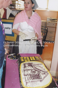
Photograph, Fay Bridge, Eltham Primary School No. 209, Dalton Street, Eltham, 12 August 2006
ELTHAM PRIMARY SCHOOL CELEBRATIONS (EDHS Newsletter No. 170 September 2006) On 12 August the school celebrated its 150th anniversary with a most successful open day. Many former students, teachers and parents attended, together with local members of parliament and councillors. A congratulatory message from Premier Steve Bracks and Education Minister Lynne Kosky was read to the large crowd assembled to listen to the various speakers. Our members Jock Read and Geof Braithwaite were there as two of the longest surviving former students. Jock joined the youngest present day student in cutting the large birthday cake. Displays included historical information on Eltham and the school arranged by our Society and photos of school groups arranged into decades. The celebrations included the launch of a book to commemorate the event and titled "We Did Open a School in Little Eltham". The title is taken from a line in a letter from first head teacher David Clark who opened his first private school in a bark hut. This excellent publication of some 262 pages far exceeds the standard of most school commemorative histories, both in content and presentation. The three joint writers are all parents of students at the school. Ian Anderson, Barry Carozzi and Tarja Fellowes have spent many months researching and writing and are congratulated on the outcome. In the book they acknowledge the contribution of our President Harry Gilham and of Peter Cuffley, great grandson of Eltham pioneer Thomas Sweeney, Many of the photographs were provided by our Society. The stone building is the earliest building remaining on site today. It was built in 1875 and was the second school building replacing the original 1856 building of stone walls with wooden shingles on the roof. That building needed to be replaced after the stone walls collapsed outwards. In August 1912 the school issued a requisition for remodelling of the school concerned with replacement of the existing windows with larger and wider windows to allow additional light into the school rooms and the erection of a wooden partition in the centre of the room. An extension to the building at rear and skylights in the roof were added in 1921. Only two low wooden stairs were originally provided to enter the porch. These were rebuilt by 1928. A steel mud grate was introduced 1930s/1940s and an infant shelter shed circa 1945.fay bridge collection, eltham, 150th anniversary, 2006-08-12, eltham primary school, eltham state school no. 209 -
 Eltham District Historical Society Inc
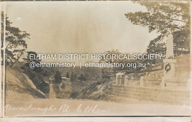
Postcard - Photograph postcard, Greensborough Road, Eltham, c.1925
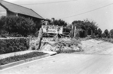
Rare postcard showing view looking down Bridge Street with the Eltham Obelisk in situ in its original location. The Obelisk War Memorial was unveiled 3 August 1919. Subsequent to the unveiling provision was made of a stone retaining wall topped with a chain link and granite stone boundary. Along with the use of the name Obelisk Corner, the Bridge Street bridge was also known as Obelisk Bridge. The Obelisk was relocated to the fornt garden of the Eltham RSL sub-branch in the mid 1950s as a result of road widening and corner improvements. The Bridge Street Bridge was replaced with a new concrete bridge in 1956-1957.Digital file only Postcards scanned from the collection of Michael Aitken on loan to EDHS, 2 Sep. 2022michael aitken collection, eltham, postcards, bridge street, bridge street bridge, obelisk, obelisk corner, eltham cenotaph, eltham obelisk, war memorial, main road -
 Eltham District Historical Society Inc
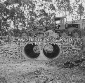
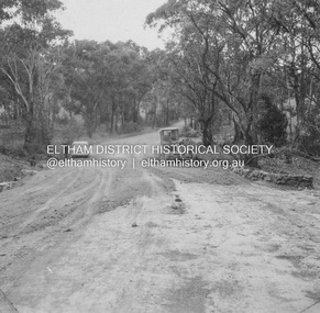
Album - Photograph, J.A. McDonald, Heidelberg-Kinglake Road, May 1957
Wild Dog Creek (Day Labour) 56M346 Two rows 6’0” pipe May 1957 Showing culvert and stone wallsRecord of various Shire of Eltham infrastructure works undertaken during the period of 1952-1962 involving bridge and road reconstruction projects, sometimes with Eltham Shire Council Project Reference numbers quoted. It was during this period that a number of significant improvements were made to roads and new bridges constructed within the shire that remain in place as of present day (2022). In many situations, the photos provide a tangible visible record of infrastructure that existed throughout the early days of the Shire. The album was put together by or under the direction of the Shire Engineer, J.A. McDonald.infrastructure, shire of eltham, bridge construction, heidelberg-kinglake road, road construction, 1957-05, wild dog creek -
 Eltham District Historical Society Inc
Document - Property Binder, 801 Main Road, Eltham
1. Plan: Henry Dendy's Eltham Land 1857-1867: showing Diamond Creek, Bridge Street, Maria Street now Main Road, John Street, Pitt Street, St Margaret's Church 1861, and Eltham Community Centre 1987. 2. Photocopy extract from "Henry Dendy and his emigrants" by L A Schumer, re Portions 12 and 13, Parish of Nillumbik. 3. The President and Councillors of the Shire of Eltham request the pleasure of ____ at the Official Opening of the Eltham Community Centre, Cnr Main Road and Pitt Street, Eltham by the Honorable R.J. Hamer E.D., M.P., Premier of Victoria on Saturday, 22nd April, 1978 at 3.30pm 4. Souvenir Program, Opening of Eltham Community Centre 22 April 1975. 5. Invitation to attend Official Opening of Eltham Community Centre by R J Hamer, Premier of Victoria, 22 April 1975. 6. Flier for Eltham Reception and Conference Centre, photographs of interiors during events. 7. Newspaper article: Eltham buries present for the future, Diamond Valley News 19 November 1985 Eltham, photograph of burying time capsule outside Eltham Community Centre, photograph of Bill Baker and Sid Brown outside old blacksmith shop the original site of Eltham town centre. 8. Letter Peter Butler Shire of Eltham to Eltham District Historical Society, 6 July 1987, detailing process for naming of the halls at the Eltham Community Centre.6 July 1987. 9. Plan of Main Road Eltham - it depicts buildings and occupiers from Pitt Street to Luck Street in the first half of the 20th century. This plan was compiled as a joint efforts by members of the Shire of Eltham Historical Society at a general meeting in Eltham during the 1980s. Newspaper article: Swimming pool and community centre receive major revamps, Diamond Valley Leader, 21 October 2015.main road, eltham, eltham community centre, henry dendy, eltham reception and conference centre, bill baker, sidney brown blacksmith, tme capsule, arthur street, babe taylor house, bakery, boarding house, bradley house, bridge street, brown blacksmith, burgoyne's shop, cockcrofts store, commercial bank of australasia, david lyon house, davis, dr cordner, dr hall, dudley street, eltham hotel, eltham obelisk, eltham war memorial, garnet burges, graham, hawker, henry street, john lyon, len perron, luck street, lyons garage, map, mechanics insitute, monteith house, mrs morris shop, our lady help of christian’s primary school, panther place, pitt street, prior street, shillinglaw cottage, shops, stones mixed shop, websters house, wesleyan methodist church, york street -
 Eltham District Historical Society Inc
Photograph, Looking southeast near 80 Bible Street, Eltham, c.September 1966, 1966c
The end of the stone wall is the border between 78 and 80 and the extension of the stonewall is distinctly visible todayBlack and white photographic printIlford paper stamped 8963 Originally located in a Filmpro King Size Prints processing envelope $3.01 Shire of Eltham 9/9/66 and noted as Calrossie Ave area and crossed out Eltham-Yarra Glen Road, Bridge Street to Elsa Court existing conditions mid 1967bible street, road construction, streets -
 Eltham District Historical Society Inc
Document, Russell Yeoman, Tour of Historic Buildings and Locations, 1978
Self guided heritage tour information produced by the Shire of Eltham Historical Society for 1978 Eltham Community Festival of 36 locations each numbered on accompanying map. Locations and detail provided current to 1978: 1. ELTHAM SHOPPING CENTRE Whilst very little remains in the centre of historical importance, this area has interest as the "village" which developed over many years following the opening of the railway from Melbourne in 1902. Previously the shopping centre had been spread out over a long length of Main Road to the south. Shops have been continuously demolished or remodelled and the majority of buildings date from the 1950's or later. The recently erected Post Office replaced the "old" Post Office opened on the same site only in 1958. 2. WOOLWORTHS ELTHAM VILLAGE Part of the site of this modern shopping development was occupied by the former Eltham Shire Offices and Hall. The hall was paid for by public subscription whilst the Council raised a loan for the offices. The combined building was opened in 1941. It served as office and Council meeting place until 1965 and as the hall until its demolition in 1970. 3. ELTHAM WAR MEMORIAL The complex of buildings adjoining the present Shire Offices were financed by public subscription as a Memorial following World War II. Their construction and for many years their operation was organised by the now disbanded Eltham War Memorial Committee. The original buildings were the; Infant Welfare Centre, Children’s Library (now War Memorial Hall and Dental Clinic) and Kindergarten. In later years the Elderly Citizens Club was built at the rear. 4. ELTHAM SHIRE OFFICES These offices were opened in 1965 and extended in 1971 to provide additional office accommodation and the Eltham Library. They represent the last of a long line of offices and meeting places of the Eltham Shire Council and its predecessor the Eltham District Road Board. The building occupies the former site of Shillinglaw Cottage. The three tall cypress trees which stood in front of the Cottage have been retained as a feature of the office surrounds. 5. OUR LADY'S CHURCH AND SCHOOL The Catholic Church and School complex opposite the Shires Offices shows a number of stages in the development of Eltham township. The recently constructed church adjoins its predecessor (now the parish centre). Many years ago the Catholic Church was located opposite Wingrove Park and the present central site follows the northerly drift of the township. 6. SHILLINGLAW COTTAGE The Cottage was built in 1859 by George Stebbing, a local builder who was responsible for a number of other prominent buildings in the area. Its removal from the site of the Shire Offices and re-erection on the present site was financed by public subscription. It is built of handmade bricks laid in Flemish Bond with an unusual design featuring burnt "leader" bricks over the whole facade. The Cottage is occupied by Eltham Fleececrafts and will be open during the Festival and at other times during weekends. It is classified by the National Trust. 7. RAILWAY BRIDGE The timber trestle bridge over the Diamond Creek was built in 1901. Whilst all of its timbers have been replaced at various times over the years the only change to its character has been the addition of pylons and wiring for electric trains in 1923. It is one of very few similar bridges remaining in the metropolitan area. In 1976 a proposal to replace the bridge with an earth embankment and large culvert pipes was abandoned following community protests. The bridge, however, remains under threat because of the necessity for future deuplication of the railway line. 8. ELTHAM CENTPAL PARK The area between the railway and the creek has for many years been used as a park which included Eltham' s main football oval. The access road, Panther Place is named after Eltham's team playing in the Diamond Valley League. In recent years a large area extending to Bridge Street and locally known as the Town Park has been landscaped and added to the area. The excellent blending of the park with the natural landscape of the creek valley has earned a National Trust Landscape Classification. 9. OLD BAKERY On the southern corner of York Street and Main Road is an old house with a shop front which was for many years the local baker's shop. The brick bakery at the rear is of somewhat later vintage than the house. 10. BRIDGE STREET CUTTING Before reconstruction of Main Road this intersection had deep cutting embankments on all four corners, forming a distinctive feature of the entrance to Eltham. Roadworks and private development have levelled the land on the low side of the road. A memorial to the Eltham soldiers of World War I which was located at the north-western corner is now situated at the Eltham R.S.L. 11. HILLTOP MILK BAR For many years this was the site of the Eltham Post Office under the control of the Hunniford family and later their descendants the Burgoynes. It was transferred to this site in 1855, although at that time the building apparently fronted Bridge Str e et. The site contained Eltham's first telephone exchange. The post office was relocated in 1954 but the shop was operated until recently by the Burgoyne family who still own the surrounding land. 12. UNITING CHURCH and former C.B.A. BANK The former Methodist Church was built in 1880 by George Stebbing. The Sunday School extension was built in 1929 and there have been more recent extensions. The adjoining opportunity shop was built as a bank in 1874 and purchased by the Methodist Church in 1954. 13. R.S.L. HALL, TELEPHONE EXCHANGE These relatively recent buildings occupy the site of a row of shops forming part of the early ribbon of business development along Main Road. In front of the R.S.L. building is the World War I Memorial relocated from the corner of Bridge Street and Main Road. 14. ELTHAM COMMUNITY CENTRE Australia's first mudbrick "community building" was opened in April this year. Part of the site of the building was purchased in 1856 by Henry Dendy (of Brighton fame). At the rear of the land near the creek was a steam flour mill whilst Dendy's house was at the Main Road frontage of the land. His purchase totalled about 2 Ha (5 acres) and included land on the opposite side of Maria Street (Main Road). Dendy became a prominent member of the Eltham community and served one term as President of the Eltham District Road Board. In 1867 Dendy sold his land and business to William Ford of Malmsbury and shifted to Walhalla. The avenue of trees leading past the Community Centre to the creek may well have bordered the track to the mill. 15. ELTHAM HOTEL The original part of this hotel was built in 1927 following the burning of the former Watson's Eltham Hotel on the same site. The car park on the opposite side of Main Road was also the site of a hotel variously known over the years as; the Fountain of Friendship, the Fountain and the Evelyn Arms. As the Fountain of Friendship it was the first meeting place of the Eltham District Road Board in 1856. 16. ST. MARGARET'S CHURCH, PITT STREET In 1860 Henry Dendy was appointed Chairman of a committee to establish a church of England in Eltham. He donated part of his land in Pitt Street and in 1861 the church was opened. It was built by George Stebbing and remains in a well preserved state today. Th adjoining old vicarage is now named Dendy Hou se. A new mudbrick church hall is under construction on the site. The church and Dendy House are now listed on the Register of Historic Buildings. 17. NO. 86 PITT STREET Cottage built by George Stebbing and believed to be his home for some years in the 1850s. 18. LIVING AND LEARNING CENTRE The house was built in the 1850s with the kitchen at the front being added about 40 years later. By the creek below the house a number of early Eltham industries were located. These included a tannery and a brewery. 19. ELTHAM COURT HOUSE A Court of Petty Sessions was established in Eltham in 1858 and the present building dates from 1860. It is the oldest public building remaining in Eltham. In its early days the building was used as the meeting place and office of the Eltham District Road Board and as an overflow classroom for the local school. The Court House has been classified by the National Trust. The citation states that it is an example of the simple form of early brick Court House with gabled roof and porch. 20. LANDS DEPARTMENT OFFICE This building is the former police station and is probably of about the same age as the Court House. The lockup at the rear has been demolished but the old stables remain as garages. A licence was first granted for a police station at Eltham in 1856. 21. JARROLD COTTAGE The old Cottage opposite Dalton Street was formerly owned by the Jarrold family. Early records indicate that this was the building leased from the Jarrolds as a temporary police station prior to construction of the building on the corner of Brougham Street. The small building on the corner of the property was used as a boot repairer's shop. The elevated studio at the rear is a more recent construction by the present owners. 22. STATE SCHOOL RESIDENCE Erected in 1891 23. WINGROVE COTTAGE This building fills an important place in the history of Eltham and is now used as a medical clinic. It was built in 1858 for Charles S. Wingrove who was Secretary to the Eltham District Road Board and Shire Council from 1858 to 1904. During part of this period he was also Shire Engineer and was Secretary to the Heidelberg Road Board. The house was used as the office of the Board and Council for many years. Wingrove is buried in the cemetery at St. Helena. 24. WINGROVE PARK The parkland opposite Wingrove Cottage has been named after Charles Wingrove. The old Manna Gums are an outstanding feature of the park. 25. ELTHAM FRI.MARY SCHOOL NO. 209 The school first opened in the slab building in 1855 and operated from the present site since 1857. The oldest part of the present school is the stone building erected in 1876. The first school teacher, David Clark remained at the school until 1888. This school is the government township and has always been known as the Eltham School. An earlier school (no.371) known as Little Eltham School operated in Swan Street from 1853 to 1872. 26. "SHOESTRING" This house was built for school teacher David Clark. It has been extensively extended in recent years but the extensions do not detract from the character of the older part of the building. 27. ELTHAM CEMETERY The cemetery contains the graves of many of the district's pioneers . 28. MONTSALVAT This unique complex of buildings was commenced in 1935 by the late Justus Jorgensen and its development has extended over many years. Montsalvat has exerted a significant impact on Eltham The earth and stone construction of many of the buildings has influenced local architecture to a great extent and it has served as a "nerve centre" of the local artistic community. Montsalvat is open to the public for a small charge. 29. MAIN ROAD BRIDGE This location has been the main crossing of Diamond Creek since the earliest days of settlement. The present concrete bridge was erected in 1925 .and was preceded by a number of timber bridges. 30. ELTHAM LOWER PARK This park, being an unusually large flat area for Eltham, was originally the local racecourse. Horse races were held here from 1855 and the area was gazetted as a reserve for a racecourse and recreation reserve in 1857. The park is well known as a venue for school "bird days" and more recently as the site of the Diamond Valley Railway. This miniature railway features scale models of modern and old locomotives and rolling stock and has operated on this site since 1961 . Before that the railway operated at Chelsworth Park, Ivanhoe. 31. FALKINER HOUSE Frederick Falkiner was one of the earliest settlers in the Eltham township area and occupied a substantial leasehold prior to the first land sales. Early records show that Falkiner was the subject of a number of complaints from his neighbours but he has nevertheless been considered a prominent enough citizen to have a street named for him. This house was the home of Evelyn (Ely) Falkiner a member of Frederick's family. 32. WEST HOUSE Behind the large house on the hill is an early house built by the West family. This was relocated from a site near the front of the land by the present owner Mr. Fabbro. 33. FALKINER HOUSE This very old house is believed to have been the home of Frederick and may have been Eltham's first post office. Falkiner was the first post master for a short period. in 1854/55. 34. WITHERS HOUSE This house was the home of famous artist Walter Withers who shifted here from Heidelberg in 1903. 35. ELTHAM HIGH SCHOOL This school celebrated its jubilee this year, having commenced as the Eltham Higher Elementary School 50 years ago. 36. DIAMOND CREEK FOOTWAY If returning from the High School to the town centre the footpath by the bank of the Diamond Creek provides a pleasant route to finish your walk. The creek is a major tributary of the Yarra River. Together with its own major tributaries Arthurs Creek and Running Creek it commences on the southern slopes of the Dividing Range at Kinglake. It gives the name Diamond Valley to an area extending well beyond its actual drainage catchment.Recognition of the significance of various landmarks to the history of the Eltham community as of 1978‘shoestring’, 1978, bridge street cutting, burgoyne store, c.b.a. bank, diamond creek trail, eltham cemetery, eltham central park, eltham community centre, eltham community festival, eltham court house, eltham festival, eltham high school, eltham hotel, eltham lower park, eltham primary school, eltham railway trestle bridge, eltham shire offices, eltham shopping centre, eltham state school no. 209, eltham village, eltham war memorial, falkiner house, heritage trail, hilltop milk bar, jarrold cottage, lands department office, living, living and learning centre, main road bridge, montsalvat, old bakery, our eltham artistic recollections, our lady help of christian’s church, our lady help of christian’s primary school, pitt street, post office, r.s.l. hall, shillinglaw cottage, st margaret’s church, state school residence, stebbing cottage, telephone exchange, uniting church, west house, wingrove cottage, wingrove park, withers house, woolworths -
 Eltham District Historical Society Inc
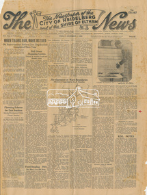
Newspaper, The News: The Newspaper of the City of Heidelberg and of the Shire of Eltham; Friday, December 1, 1950, 1950
Page 1 article about the laying of the foundation stone for the Baby Health Centre by the Governor of Victoria (Sir Dallas Brooks) on Friday, November 24, 1950 (including photograph of Sir Dallas Brooks laying the stone) History of the War Memorial Following the end of the First World War, communities across Victoria and Australia typically erected memorials which were predominantly statues, cenotaphs, avenues of honour and plaques. The Shire of Eltham established the Avenue of Honour at the gateway to the shire as well as an obelisk at the corner of Main Road and Bridge street and the Shire of Eltham War Memorial Tower at Kangaroo Ground. After the Second World War communities once again desired to preserve the memories of those who served and paid the ultimate sacrifice. Resources were scarce so there was a transition away from the traditional style memorials that sprang up post 1918 to one of building facilities that would provide ongoing benefit to the community. Even before the end of the Second World War, the citizens of Eltham began to consider an appropriate form of memorial for those from the area who fought and died in the First and Second World Wars. In 1943 the Eltham Women’s Auxiliary raised funds for the construction of buildings to be established on land to be purchased for the proposed War Memorial. On March 27th, 1945, the Eltham District Progress Association called a meeting of local people who in turn set up and registered the Eltham War Memorial Trust Inc. As a focus for the purpose of the memorial, the newspaper notice read:- ‘Those who have had a member of their family in the fighting services will want to see that the form of a memorial we are concerned with is the one which will be a constant reminder to us of those who fought for us and the little ones for whom they fought and died.’ At that meeting it was decided the Memorial should take the form of a baby health centre along with a creche and children’s library. In late 1945, the newly formed Eltham War Memorial Trust purchased the land at 903-907 Main Road Eltham from Miss Shillinglaw, which once formed part of the Shillinglaw farm on Lot 90 of Holloway’s 1851 “Little Eltham” subdivision. The Governor of Victoria, General Sir Dallas Brooks, laid the foundation stone on November 24th, 1950, in memory of those who fell in the Second World War. The Eltham Infant Welfare Centre was opened November 15th, 1952, the Pre-school on December 1st, 1956, and the Children’s Library in 1961. In late 1966 the children’s library service was integrated into the Heideberg Regional Library Service and the building was officially renamed the Eltham War Memorial Hall. Following the opening of the Eltham Infant Welfare Centre, work began in 1953 planning for the entrance to the grounds, which is signaled by a wrought iron arch entitled “Eltham War Memorial” . In 1954 the Eltham War Memorial Trust decided that a legacy provided by the late Councillor Ernest James Andrew (d. 29 March 1950) in memory of his wife, Mrs. Ellen Andrew (d. 13 July 1946) and who are both buried at Eltham Cemetery, should be used to fund the construction of the entrance. A metal plate inscribed to this effect was attached to the gates. Work on the Memorial Gardens was undertaken throughout the following decade, with a Memorial Forecourt included in the final 1956 plans for the Pre-School Centre. A quote was accepted by the Trust in 1963 for the implementation of a memorial garden, which included grading of a sixty-five foot strip at the rear of the Trust buildings and construction of concrete paths. The stone retaining walls at the front of the site were installed in 1968 when Main Road was widened and it is believed that the Memorial Gates were relocated at that time also. Eltham Senior Citizens Centre In 1964, Eltham Shire Council purchased a section of land from the Trust at the northern end of the site, as a provision for Country Fire Authority buildings. At the same time the Elderly Citizens Club proposed a Senior Citizens Centre on the south western section of the Trust’s property. This was approved by the Trust with the provision that the building was constructed in ‘accord’ with those already existing. In 1965 Council took on board the plans for the Senior Citizens Centre and applied for a government grant. These could only be awarded if Council owned the site. In 1962 the Trust had resolved to hand over the assets to Council once the Memorial Gardens were completed. This was in line with Health Department requirements that grants for the ongoing operation and maintenance of the three facilities would only be made once the the facilities were completed and handed over to Council. In 1965 the Department of Health further demanded substantial alterations to the Pre-School playground as a result of the pending impact of the planned Senior Citizens Centre and Main Road duplication. As a consequence, handover of the Trust’s assets to Council was initiated with a formal ceremony held in the Children’s Library on August 28th, 1965. The Trust continued on as a committee of management for another twelve months. Plans and specifications for the Senior Citizens Centre were prepared by March 1966. Council obtained a grant from the Government which covered one third of the cost and the building was completed by April 1967. Whilst the Senior Citizens Centre is contained within the original Eltham War Memorial building precinct, it was not part of the original Memorial and was not funded by the Eltham War Memorial Trust.Newspaper Broadsheet, 8 pageseltham children's library, eltham infant welfare centre, eltham pre-school, eltham war memorial hall, eltham war memorial trust, women's auxiliary -
 Eltham District Historical Society Inc
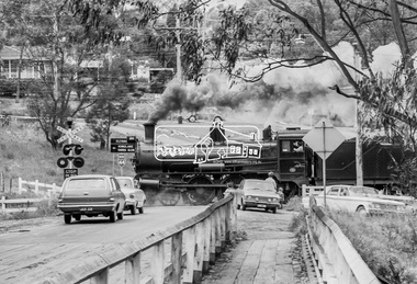
Photograph, Steam locomotive D639 with Tait (Red Rattler) carriages passing through the level crossing at Wattletree Road, Eltham bound for Hurstbridge, c.1970, 1970
Note the blue stone edging surrounding the grassy island in the intersection. This stone was originally part of the blue stone lock-up situated behind the Police Station and residence at 728 Main Road (present day Local History Centre and home to Eltham District Historical Society). Following a redesign of the intersection the stone was again relocated back to 728-730 Main Road for use as garden edging.Digital TIFF file Scan of 35mm Ilford HP4 black and white transparency728 main road, d-639, eltham, level crossing, local history centre, lockup, main road, police station, railway parade, red rattler, steam engine, wattletree road, wattletree road bridge -
 Phillip Island and District Historical Society Inc.
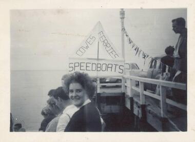
Photographs, 1940
Four of a collection of 33 photographs donated by Leonie Brennan. The collection belonged to Edward (Ted) Sands, hairdresser.Photograph 215-18. People on the Cowes Pier enjoying an event. A sign reads "Cowes - Ferries - Speedboats" and a string of bunting decorates the pier. There are also cars on the pier. Photograph 215-19. Phillip Island - San Remo Suspension Bridge viewed from Newhaven at very low tide. Photograph 215-20. A couple enjoying a picnic in a bush setting. Photograph 215-21. Three people sitting on the stone fence in front of the Isle of Wight Hotel. A large sign shows "ENTRANCE RESIDENTIAL & BAR - MELBOURNE BITTER"isle of wight hotel, isle of wight hotel phillip island, phillip island - suspension bridge, suspension bridge phillip island, cowes pier phillip island, mr edward (ted) sands, leonie brennan -
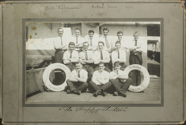 Mission to Seafarers Victoria
Photograph - Mounted photograph, Sepia, S.S. Tasmania's Football Team, 1922
... in ink : Thomas Holohay / William Bridges / James. H. Stone... / William Bridges / James. H. Stone / George Angus / James Arthurs ...This is a photograph of crew members that formed the football team of the S.S. Tasmania. Taken place on the deck of the ship, it is a snapshot in timeAn addition to the collection of crew photographs in the MTSV Collection with all crew members featured in the image named and dated with name of ship making it a useful research and reference image.Black and white photograph of S.S. Tasmania football team in 1922. The photograph is mounted onto a grey green cardboard frame with the text, 'S.S. "Tasmania's" Football Team 1922' on the top. The bottom reads, 'The Happy Thirteen', handwritten in black ink. The photograph itself is of 13 men in three rows, 6 on top row standing, 4 in the middle row sitting on a bench and 3 on the bottom row sitting with their legs crossed. All men have their arms crossed across their chest. On either side of the front row is a lifesaver with the text "S.S. Tasmania/Plymouth". The men are posed on the ships deck. On front mount with photograph: 'S.S "Tasmania's" Football Team 1922' / The Happy Thirteen Inscribed back:of mount names in ink : Thomas Holohay / William Bridges / James. H. Stone / George Angus / James Arthurs / George Arthurs / C. Quinell / C. (Lawrence/labence ?) / W. Manon / M. Zard / I. Ancell LT/JL ?. Chipperfield / F. Franksuniform, team, s.s. tasmania, 1922, football, crew, life buoy, crews and ships -
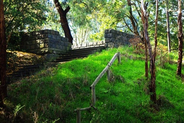 Greensborough Historical Society
Photograph - Digital Image, Pioneer Reserve 2014 -1, 21/05/2014
Pioneer Reserve, Greensborough is a small park on the corner of St Helena and Diamond Creek Roads. It is adjacent to the site of Greensborough's first bridge across the Plenty River, c. 1864 - 1960s. The shelter, viewing platform, retaining wall and entrance are built from the bridge's massive bluestone arched abutments dismantled between 1974 and 1983. Pioneer Reserve is historically significant for its formative association with noted local landscape designer Gordon Ford in 1968, and it is likely that remnant large field stones at the entrance drive to the Reserve remain from his design. Photograph by Marilyn Smith 2014.Digital copy of colour photograph. -
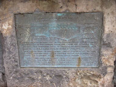 Greensborough Historical Society
Photograph - Digital image, Dennis Ward, Bridge Plaque - Pioneer Park Greensborough, 27/03/2010
Plaque at Pioneer Reserve Greensborough: "Shire of Diamond Valley. The bluestones used in the construction of this viewing platform and in the carpark entry structure and retaining wall are from the northern arch of Greensborough's first Plenty River Bridge built in the 1860s adjacent to this site. The centre span of the original bridge was removed in 1865 when the western half of the existing bridge was constructed leaving the northern and southern stone arches. The southern arch was retained until floods in 1874 necessitated its removal. The picnic shelter in this reserve was constructed using stone from this abutment. The northern arch was removed in 1983 when widening of the existing bridge commenced."Digital copy of colour photograph.plenty river, pioneer reserve greensborough -
 Glenelg Shire Council Cultural Collection
Card - Card / Photo - Melbourne Photography Company, n.d
Burgundy card with black and white photo attached to front. Young man in formal attire standing next to stone wall, hand on urn. 'Melbourne Photography Company BRIDGE STREET BALLARAT' printed in gold, beneath photBack: Piece of masking tape, top edge of card, with GRANDFATHER VIVIAN' hand printed, blue biro -
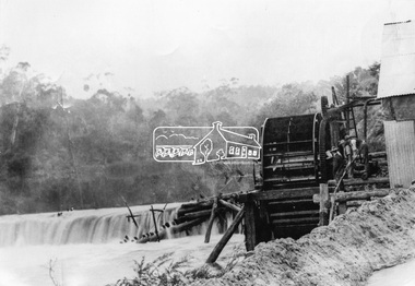 Eltham District Historical Society Inc
Photograph, Remains of the old Water Wheel and Battery, Warrandyte, 1934
A short distance upstream from the old wooden Warrandyte Bridge, the Yarra river was at one time dammed to give power to a large wooden waterwheel which drove a plant for crushing gold. Up until around 1908 the waters of the Yarra, pent up by a stone weir, forced their way past this old wheel turning it to crush the precious quartz. In 1925 the reamins of the State Battery were removed. The large water wheel (thanks to the forethought of a local resident, Mr. P. Mackie) was left in its position.This photo forms part of a collection of photographs gathered by the Shire of Eltham for their centenary project book,"Pioneers and Painters: 100 years of the Shire of Eltham" by Alan Marshall (1971). The collection of over 500 images is held in partnership between Eltham District Historical Society and Yarra Plenty Regional Library (Eltham Library) and is now formally known as the 'The Shire of Eltham Pioneers Photograph Collection.' It is significant in being the first community sourced collection representing the places and people of the Shire's first one hundred years.Digital image 4 x 5 inch B&W Negshire of eltham pioneers photograph collection, warrandyte, water wheel, caledonia battery, state battery, warrandyte battery -
 Eltham District Historical Society Inc
Negative - Photograph, Warrandyte Bridge over River Yarra, c.1910
View of the 1875 timber trestle bridge over the Yarra River reproduced from a newsprint image. Also known as Anderson's Creek (Road) Bridge A contract was accepted for William Elliot to erect a bridge over the Yarra River at Warrandyte on Anderson's Creek Road and other improvements for £1,331.6.2 - Gazette No. 143. Tuesday, November 13th 1860 - http://gazette.slv.vic.gov.au/view.cgi?year=1860&class=general&page_num=2161&state=V&classNum=G143&id=). The bridge was washed away by floods in 1863. It was replaced with a taller timber trestle structure in October 1875, designed and built by C.S. Wingrove, Shire Clerk, Engineer and Surveyor for Eltham Shire Council. A replacement for this bridge was commenced in 1955 to cope with increasing traffic and this structure was widened in 2018 to meet further traffic demands. Argus (Melbourne, Vic. : 1848 - 1957), Thursday 23 September 1875, page 7 ________________________________________ THE WARRANDYTE BRIDGE. The ceremony of formally opening the newly erected bridge over the Yarra at Ander-son's Creek was performed on Monday last, in the presence of the members of the Eltham and Bulleen shire councils whose territories it joins, and a goodly number of the residents of the district. The task was delegated to Mr. Cameron, M.L.A., who, after a few introductory remarks declared the bridge to be opened, and christened it the " Warrandyte Bridge." The party then adjourned to Grant's Hotel, where a cold collation had been prepared. The chair was taken by the president of the Eltham shire (Mr. John Bell) and the vice chair by Mr. Kent, a member of the Bulleen council. Mr Robert Williamson proposed "Success to the bridge," coupling with it the name of Mr. Cameron, to whose exertions was in the main to be attributed the erection of that structure which was an ornament to the district and would prove of great service to both sides of the river. Mr. Cameron, in responding, alluded to the great difficulties, mainly of a pecuniary nature, that had been encountered in carrying out the project, and which had only been got over by their united efforts and by the liberal spirit in which the late Commissioner of Roads had dealt with the case. The healths of the contractor and the engineer were also drunk. The bridge is a trussed timber one, resting on yellow box piles sunk into the solid rock, each pier being weighted with 50 tons of stone. The abutments consist of dry stone walls, 6ft. thick at the base, and tapering to 3ft. on the top, the face of the work having a batter of 1 to 1. The length of the bridge is 308ft., there being four openings in the centre of 66ft. each, and two at the ends of 20ft. each. The width in the clear is 9½ft., and the height from the bed of the river about 33ft. The approaches comprise 1,100 cubic yards of earthwork, and the formation of 48 chains of sideling, the whole cost of the work, which was carried out under the direction of the engineer to the Eltham Shire Council, being £1,413.This photo forms part of a collection of photographs gathered by the Shire of Eltham for their centenary project book,"Pioneers and Painters: 100 years of the Shire of Eltham" by Alan Marshall (1971). The collection of over 500 images is held in partnership between Eltham District Historical Society and Yarra Plenty Regional Library (Eltham Library) and is now formally known as the 'The Shire of Eltham Pioneers Photograph Collection.' It is significant in being the first community sourced collection representing the places and people of the Shire's first one hundred years.Digital image 4 x 5 inch B&W Neg B&W Print 12.5 x 9 cmsepp, shire of eltham pioneers photograph collection, warrandyte, bridge -
 Eltham District Historical Society Inc
Negative - Photograph, Eltham War Memorial Obelisk 1914-1918, cnr. Main Road and Bridge Street, c.1925
Located on what was referred to as Obelisk Corner, improvements have been been made since the unveiling in August 1919 with the provision of a stone retaining wall topped with a chain link and granite stone boundary, most likely in conjunction with improvements to the intersection into Main Road. Along with the use of the name Obelisk Corner, the Bridge Street bridge was also known as Obelisk Bridge. The Eltham Obelisk was originally located at the corner of Bridge and Main Roads in 1919. In 1943 (WW2) the local community commenced plans to establish the Eltham War Memorial, a living memorial to benefit the children as opposed to a one in stone as per the obelisk. The Eltham War Memorial Trust was established in 1945. In 1947 the Trust intended for the Obelisk to be relocated from Bridge Street and Main Road to the Garden of Remembrance which was planned as part of the Baby Health Centre which was to be the first of three buildings of the Eltham War Memorial to be built in 1951. In 1951 the Eltham RSL was invited to be represented on the Eltham War Memorial Trust. Around this time, with pending roadworks, the obelisk was relocated to the front garden of the Eltham RSL sub branch on Main Road for safe keeping. In 2007, a suggestion was proposed by Harry Gilham (President, EDHS) to John Cohen (ERSL) to claim a special site along with the historic Shillinglaw trees on the now vacant former Eltham Shire Office site adjacent to the Eltham War Memorial precinct for relocation of the obelisk. In 2010 following the financial collapse and sale of the Eltham RSL Sub-Branch property and amalgamation with the Montmorency Eltham RSL sub-branch, the location of the obelisk was again in immediate jepoardy and in conjunction with Nillumbik Shire Council, the obelisk was relocated in front of the Eltham War Memorial buildings in preparation for the Dawn Service on Anzac Day 2012.This photo forms part of a collection of photographs gathered by the Shire of Eltham for their centenary project book,"Pioneers and Painters: 100 years of the Shire of Eltham" by Alan Marshall (1971). The collection of over 500 images is held in partnership between Eltham District Historical Society and Yarra Plenty Regional Library (Eltham Library) and is now formally known as the 'The Shire of Eltham Pioneers Photograph Collection.' It is significant in being the first community sourced collection representing the places and people of the Shire's first one hundred years.Digital image 4 x 5 inch B&W Negsepp, shire of eltham pioneers photograph collection, eltham, main road, eltham war memorial, bridge street, obelisk, obelisk corner -
 Eltham District Historical Society Inc
Photograph, Eltham War Memorial 1914-1918. Cnr. Main Road and Bridge Street, 3 August 1919
Dated 1919, the Eltham Obelisk is decorated with wreaths, most likely for what was originally known as Armistice Day though now known as Remembrance Day, 11 November. The location of the Obelisk at the corner of Bridge Street and Main Road became known as Obelisk Corner and the Bridge Street bridge was also referred to as Obelisk Bridge. The Eltham Obelisk was originally located at the corner of Bridge and Main Roads in 1919. In 1943 (WW2) the local community commenced plans to establish the Eltham War Memorial, a living memorial to benefit the children as opposed to a one in stone as per the obelisk. The Eltham War Memorial Trust was established in 1945. In 1947 the Trust intended for the Obelisk to be relocated from Bridge Street and Main Road to the Garden of Remembrance which was planned as part of the Baby Health Centre which was to be the first of three buildings of the Eltham War Memorial to be built in 1951. In 1951 the Eltham RSL was invited to be represented on the Eltham War Memorial Trust. Around this time, with pending roadworks, the obelisk was relocated to the front garden of the Eltham RSL sub branch on Main Road for safe keeping. In 2007, a suggestion was proposed by Harry Gilham (President, EDHS) to John Cohen (ERSL) to claim a special site along with the historic Shillinglaw trees on the now vacant former Eltham Shire Office site adjacent to the Eltham War Memorial precinct for relocation of the obelisk. In 2010 following the financial collapse and sale of the Eltham RSL Sub-Branch property and amalgamation with the Montmorency Eltham RSL sub-branch, the location of the obelisk was again in immediate jepoardy and in conjunction with Nillumbik Shire Council, the obelisk was relocated in front of the Eltham War Memorial buildings in preparation for the Dawn Service on Anzac Day 2012.This photo forms part of a collection of photographs gathered by the Shire of Eltham for their centenary project book,"Pioneers and Painters: 100 years of the Shire of Eltham" by Alan Marshall (1971). The collection of over 500 images is held in partnership between Eltham District Historical Society and Yarra Plenty Regional Library (Eltham Library) and is now formally known as 'The Shire of Eltham Pioneers Photograph Collection.' It is significant in being the first community sourced collection representing the places and people of the Shire's first one hundred years.Digital image 4 x 5 inch B&W Negsepp, shire of eltham pioneers photograph collection, eltham, main road, bridge street, eltham war memorial, obelisk, obelisk corner, wreath -
 Glen Eira Historical Society
Album - Album page, Hotham Street, Circa 1972
This photograph is part of the Caulfield Historical Album 1972. This album was created in approximately 1972 as part of a project by the Caulfield Historical Society to assist in identifying buildings worthy of preservation. The album is related to a Survey the Caulfield Historical Society developed in collaboration with the National Trust of Australia (Victoria) and Caulfield City Council to identify historic buildings within the City of Caulfield that warranted the protection of a National Trust Classification. Principal photographer thought to be Trevor Hart, member of Caulfield Historical Society. Most photographs were taken between 1966-1972 with a small number of photographs being older and from unknown sources. All photographs are black and white except where stated, with 386 photographs over 198 pages.Victorian Heritage Database - Hotham Street Road Overbridge HO116 Heritage Overlay - City of Glen Eira https://vhd.heritagecouncil.vic.gov.au/places/43557 (as of 04/07/2021) The Hotham Street road overbridge is located on the Sandringham railway line between Ripponlea and Elsternwick railway stations. It is presumed to have been built by contractors Sharp and Campbell who signed a contract on 25th . November, 1881 to construct a second line of railway between Windsor and Elsternwick. This contract was completed during 1882 and the bridge may have been designed in the year when Robert Watson took over from William Elsdon as engineer in chief for the Victorian railways. It is historically, aesthetically and technically significant. It is historically significant (Criterion A) to the extent that it demonstrates the standards of construction adopted by the Victorian Railways Department when it rebuilt the lines acquired from the private railway companies, (compare the Geelong and Melbourne Railway Co's line from Newport to Geelong, acquired in 1860). It is aesthetically significant (Criterion E) as an intact nineteenth century structure of its type, many similar girder bridges having been renewed with concrete girders in recent years. The bluestone abutments demonstrate high standards of stone masonry and are representative of Departmental work of the period. This bridge forms one of a group of historic structures on the railway to Brighton Beach and therefore contributes to the line's cultural importance as a whole. The survival of the riveted iron girders with their bellied angle iron struts is important since these elements are representative of the civil engineering practices of the Victorian Railways at the time and constitute the technical significance (Criterion F) of the structure.Page 96 of Photograph Album with three photographs (one portrait and two landscape) from Hotham Street - two external views of one house and a railway bridge.Handwritten: Hotham Street [top right] / 112 HOTHAM ST [under top left photo] / BRIDGE OVER SANDRINGHAM RAILWAY [under top right photo] / 112 HOTHAM ST CNR MELBY AVE [under bottom left photo] / 96 [bottom right]trevor hart, elsternwick, hotham street, caulfield, houses, brick, bay windows, verandahs, railway bridges, tunnels, gardens, bluestone, civil engineering, victorian railways, sharp and campbell, contractors -
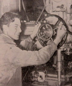 Federation University Historical Collection
Magazine - Booklet, Ballarat School of Mines Students' Magazine, 1952, 1952
School Council, Members of Staff, Editorial, Principal's Page, Magazine Committee, Obituary - Rupert P. Flower, Literary Society, Prominent Personalities, Science School, News and Notes, Prize Presentation, The Apprentices, Boys Sport, Sun Youth Travel Memoirs, The Art School, His Majesty the Late King George VI, Commercial Notes, Gleanings Here and There, Junior School, Girls Sport, Sport, House Notes, Junior Technical School Students', Roll Call - Diploma Students 1952Pale blue soft covered magazine with navy blue titles.ballarat school of mines, magazine, mr bryan, c. sanos, s. deans, j. williams, r. simpson, c. g. fairbank, d. treadwell, e. aitkens, g. birkett, g. allen, f. benjamin, s. gillespie, r. hullick, h. mccallum, h. harris, j. walton, e. walsh, j. stevens, b. clark, rupert p. flower, john bechervaise, w. keith hindson, a. james tinney, walter c. tooth, john d. bethune, vilma sansom, betty clark, travers duncan, joyce wilson, lex lockhart, jim w. beattie, joyce stevens, slim ingleton, a. eddy, john howard, douglas george dean, edgar bartrop, colin mck. henry, tom adams, max kennedy, jeff coward, o. j. nilsen, j. skuja, s. rowe, w. maddox, a. kinnane, d. fraser, a. carpenter, john james, b. flavel, j. murray, d. schmidt, g. habel, t. duncan, l. matthews, n. spiers, b. smith, a. tonnisseu, r. ingleton, j. bethune, j. mills, j. mcneil, b. schreenan, w. carlyon, d. stevens, l. j. hillman, k. hindson, r. furlong, j. beattie, b. taylor, g. heyes, l. quilliam, r. archer, a. johnson, m. gillin, t. seabrook, m. phillips, j. sawyer, c. restarick, j. saggers, g. ditchfield, j. tinney, don stewart, j. faneco, m. stevens, w. tooth, ron simpson, bill maxwell, graham searle, jim tinney, k. treloar, j. barnes, s. j. deans, lynette j. blomeley, georgina cox, heather mcgregor, janet saunders, heather harris, elizabeth mcarthur, norma coffield, pat lavery, imelda lee, gloria white, valerie westbrook, cynthia stone, janice thompson, clare mooney, glenys perry, faida lewis, betty clarke, marion volk, isla veal, valerie yates, coralie mckenzie, lorraine digby, barbara henderson, deidre wilson, margaret henderson, barbara ngip, glenys sleeth, anne duncan, l. dwyer, elaine leishman, j. jenkin, stirling gillespie, w. bridges, b. baldock, b. braybrook, e. mackie, r. braybrook, c. grose, b. mackie, c. garnham, c. schmidtke, t. lugg, j. copeman, b. tozer, g. mathews, n. sutherland, r. lambert, j. sanders, m. quick, j. collier, g. pike, r. digby, r. quayle, r. sharp, n. brogden, r. lyons, p. stevens, j. bastin, b. kay, k. duncan, b. golding, l. norman, b. murnane, k. hocking, c. sealey, b. langdon, f. weightman, m. birch, r. stevenson, r. stewart, r. haintz, k. mccoll, k. jarvis, l. hocking, d. curtain, r. lazarus, e. boak, j. fletcher, b. orchard, j. squires, n. pike, j. shrader, l. reynolds, m. ritchie, g. smith, d. parkes, g. templeton, m. wunhym, v. vincent, d. robertson, d. lang, l. horwood, d. searle, d. new, v. jolly, a. minotti, b. beaumont, m. marshall, e. bowen, j. rogers, d. cody, e. kinnane, j. cunningham, j. schrader, r. horgan, j. white, n. flood, j. matthews, h. gale, k. mitchell, v. rowse, j. mayne, a. gilbert, b. warrillow, g. gilbert, n. quick, m. hall, d. furlong, n. lyons, j. richards, j. jones, l. major, d. baldock, d. dow, g. ruddick, d. howell, j. caddy, b. singleton, b. powell, r. sharpe, c. lockhart, l. daff, c. sharpe, d. irish, l. dow, a. douglas, n. twaites, j. courtney, l. beacham, n. c. cartledege, cliff sealey, j. f. collier, e. g. mackie, m. g. quick, b. l. collinson, j. n. bastin, g. e. timmins, valerie mills, j. a. jenkin, w. cowan, i. mitaxa, n. c. leckie, r. j. austin, n. coffield, d. quilliam, r. courtney, f. m. kilfoyle, p. nunn, king george vi