Showing 110 items matching "surveyor's office"
-
 Federation University Historical Collection
Newspaper, Overland Telegraph Centenary, 1972, 1972
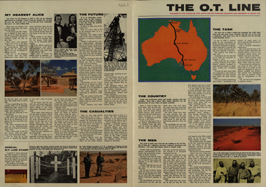
.1) Overland Centenary Supplement to The Australian. Six pages of information and images including the Roper River Camp, First Telegraph Pole at Port Darwin, Route of the Overland Telegraph, Australian Telecommunications Development Association, Alice Springs, Frew's Ponds. Charles Todd, Alice ToddFrank Kraegen, Pony Express. .2) 'The O.T. Line' - four page coloured news shhet published of by the Australian Post Office for the Overland Telegraph Line Centenary, 22 August 1972. Includes articles and images such as J.A.G. Little (Darwin Poatmaster), Robert Patterson, Charles Todd, A.J. Mitchell (surveyor), Maps of the sections (Begot's contract, Central Sections, Darwent and Dalwood contract, Patterson contract), planting of the first pole at Darwin, Roper River Camp, Charles Todd, Alice Todd, Alice Springs Repeater Station, Grave of Kavenagh, Roper River, Frank Kraegem, Maryvale station.roper river camp, telegraph pole, port darwin, overland telegraph route, australian telecommunications development association, alice springs, frew's ponds, charles todd, alice todd, frank kraegen, pony express -
 Bendigo Historical Society Inc.
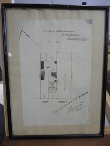
Document - DUDLEY HOUSE COLLECTION: PLAN OF DUDLEY HOUSE, 1888
Wooden framed copy of allotment plan of Old Survey Office Premises (Dudley House) Sandhurst, under glass in thin black wooden frame. Notation on bottom reads, For the information of the Secty for lands and signature of T.W.Pinniger D.S. (District Surveyor) 5/4/88T.W.Pinniger D.S.document, certificate, plan -
 Port Melbourne Historical & Preservation Society
Map - Survey Map, Captain R Pasley R E, 24 Sep 1855
... Surveyor General's Office..., September 1855 Map Survey Map Captain R Pasley R E Surveyor ...Survey map to accompany Colonial Engineers Report, September 1855melbourne -
The Ed Muirhead Physics Museum
Slide Rule, cylindrical / “FullerCalculator”
“FULLER CALCULATOR” : a wooden cylindrical slide rule(92.1) with spiral logarithmic scale 500 inches long. and specially made rectangular box (92.2) and pamphlet (92.3).Engraved on metal of adding machine (92.1): “8462/45” Label on inside of box: “Stanley Trademark Everything for the Engineer Architect and Surveyor in field and drawing office. W.F.Stanley & Co. Ltd, 286 High Holborn London WC1” Stamped on pamphlet: “University of Melbourne Department of Statistics” Label on top box: “display” -
Port Melbourne Historical & Preservation Society
Plan - Township of Sandridge, 1855
... Surveyor General's Office... of Sandridge Surveyor General's Office J Jones ...COPYRIGHT PUBLIC RECORDS OFFICE Plan of the Township of Sandrdge 1855 - copy from Public Record Office 1978local government - municipal district of sandridge, town planning, j jones -
 Bendigo Historical Society Inc.
Map - LONG GULLY HISTORY GROUP COLLECTION: LONG GULLY AREA
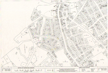
... Office of Surveyor General... Group - Long Gully Area Land Titles Office Office of Surveyor ...Copy of a map showing streets and allotments in the Long Gully area, last updated 30/05/97, printed 19/06/97. Made by the Land Titles Office. Some street names, reserves and allotment numbers are printed on the map.bendigo, history, long gully history group, the long gully history group - long gully area, land titles office, office of surveyor general, city of bendigo, shire of marong, state electricity commission -
 Bendigo Historical Society Inc.
Document - CONNELLY, TATCHELL, DUNLOP COLLECTION: ACCOUNTS ESTATE OF ESTHER ISABELL CANNING, 1893 -1894
Document. Accounts of Estate of Esther Isabelle Canning. 1 - 1894 - Account from Hinchcliffe Edwin, M. D., View Street Bendigo. 2 - 1894 - Account from Jones T R, Chemist & Druggist, Hargreaves Street, Sandhurst. 3 - 1894 - Ac. From William Bruce & Sons, B. B. Brewery, Bridge St. Bendigo, Brewers, Aerated Waters and Cordial Manufacturers, 2 April 1894. 4 - 1894 - Ac. From William Bruce & Sons, B. B. Brewery, Bridge St Bendigo, Brewers, Aerated Waters and Cordial Manufacturers. 1 March 1894. 5 - 1893 -Ac. From Burt, E Mrs, Nurse. 6 - 1894 - Receipt from Phoenix Fire Office of London, Victorian Branch, 60 Market St, Melbourne. Insurance from Fire for Property - Cottage, High St. 7 - 1893 - Receipt from Phoenix Fire Office of London, Victorian Branch, 60 Market St, Melbourne. Insurance from fire for property - Hotel, high St. 8 - 1894 - Ac from S. P. Co-Operative Co, Mitchell St, Bendigo, General Grocers, Tea and Provision Merchants. 9 - 1894 - Ac from Forbes T, Surveyor, View St, Bendigo. Subdivision of Allotment 5, Section 29A at Golden Square. 10 - 1893 - Ac from Mackay & Co, Bendigo Advertiser Office, Market Square, Bendigo. 11 - 1893 - Ac from Pritchard Geo, Aerated Water and Cordial Manufacturer, Arnold St Bendigo. 12 - 1893 - Receipt from McKenzie R C. 13 - 1894 - Ac from C H Hobson & Co, General Auctioneers, Bendigo Arcade Auction Rooms, Hargreaves St Bendigo.cottage, miners, connelly, tatchell & dunlop, hinchcliffe edwin, jones t r, william bruce & sons, b b brewery, burt e mrs, phoenix fire office of london, s p co-operative co, forbes t, mackay & co, bendigo advertiser office, pritchard geo, mckenzie r c, hobson c h -
 Bendigo Historical Society Inc.
Document - LANSELL RELATED DOCUMENTS
Document.Copy of Williamstown Historical Society Newsletter No 17 (1977).On the second and third page of this Newsletter is an article entitled ''The guns of the 'Nelson''', written by Doug Mills, Castlemaine. The Warship NELSON underwent alterations in 1860, including cut down to two decks and lengthened, her armaments reduced to 72 guns. Two 7inch 68 pounder guns were added to her armament. In February 7 1867 she was officially given to the Colony of Victoria by the Imperial Government. At the time her Commander was Captain Charles B. Payne. The Warship reached Melbourne in 4th February 1868. Relics of the NELSON were auctioned at Williamstown Victoria Naval Depot, and her two anchors are preserved for public display at Williamstown. An active demand for a share of the guns from various towns in the State. Ballarat received four (4) guns, Bendigo and Castlemaine two (2) each, while one has been given to each of the following towns: - Ararat, Tarnagulla, Hamilton, Bacchus Marsh, Echuca and Geelong. Collection of Lansell related documents: a. Copy of photograph - Lansell's Big 180 Victoria Hill - early 1870s - New Chum Hill in background. B. Lansell Estate mines - compiled from the annual report of the Hon Minister of Mines for Victoria, 1906. A listing of the George Lansell Mining Company interests at the time of his death. These were, New Moon Co, N.L., Clarence, New Prince Of Wales Co. N.L., Virginia G. M. Co., Catherine Reef United Co N.L., Great Northern Co N.L., Williams United, McDuff Amalgamated Co, South Mungo Co, South Prince Of Wales Consolidated, Constellation Co. Golden Pyke Co, Johnson's Reef Extended Company, Golden Age Co., Princess Dagmar Co, New St Mungo Co, Johnson's Reef Co, North Johnson's Co, Collman and Tacchi Co, Confidence Extended Co, G. Lansell Sandhurst Mines, Pearl Co., Windmill Hill Co., United Hustlers and Redan, Koch's Pioneer Co., Hercules and Energetic Co., Lansell's Comet, Cornish United Co., Ironbark Co., Hustler's Reef Co., and No. 1 Lansell's 83, Carlisle Co., Great Extended Hustler's Co., Victoria Consolidated Co., Great Central Victoria Co., Victoria Quartz Co., Victory and Pandora , Lansell's Big 180, Tambour Major, New Chum and Victoria Co., Garden Gully United Co., G. Lansell, Lansell's 222, Lazarus Co., Sea Amalgamated Co., Hustler's Royal Reserve Co., Horwood and Burrowe's Co., New Chum Consolidated Co., G Lansell's Sheepshead, Gariboldi Co., Londonderry Co., Shamrock Co., Great Britain Co., Fortuna Hustler's Co., Eureka Extended Co., G. Lansell's G.V.L., New Red White and Blue Consolidated, Great Southern Co., Lansell's Concord Mines, True Blue Co., G. G. Consolidated Co., Extended Red White and Blue Co., Great Columbian, Sedgwick and New Birthday. Also, a listing: ''Among the biggest yields to ate (sic) (date?) in ozs or Pounds were''; New Moon.Co. N.L. 180,087 ounces, Clarence £303,932, Catherine Reef United N.L. £762,815, Great Northern Co Ltd £394,525, Johnson's Reef Co 277,320ounces, Windmill Hill Co. 113,842ounces, Hustler's Reef Co. And No.1 1,144,923ounces, Carlisle Co 307,835ounces, Great Extended Hustlers Co £1,038,125, Garden Gully United Co. £1,653,900, Great Southern 97,752ounces, New Chum Consolidated 89,526ounces. This part (b) has handwritten inscription ''compiled by J Sarvaas MCE(??) Certified Mining Surveyor; 22/8/06''; c. Copy of Deed dated Dec 1886 between George Lansell, Wooten Lansell and the Bank of New South Wales relating to a wall and windows and openings etc etc. (3 pages of legalese!!!!!). Also, a (related?) page copy of a Grant -by purchase to the Bank of New South Wales with a date of August 1855 on it ''Enrolled in the Office of the Registrar of the Supreme Court of the Colony of Victoria - signed by Acting Registrar.document, gold, mines -
 Victorian Aboriginal Corporation for Languages
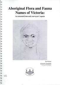
Book, Sue Wesson et al, Aboriginal flora and fauna names of Victoria : as extracted from early surveyors' reports, 2001
The Flora and Fauna Names Project is an initiative of the Victorian Aboriginal Corporation for Languages and the Victorian Biodiversity Strategy. The researcher has examined material from the archives of the Department of Natural Resources and Environment (NRE), the State Library of Victoria, the Victorian Public Records Office and the Australian Archives Office. This first stage of the project focussed on the NRE archives, in particular the field notebooks of the earliest surveyors and their maps although other NRE resources, libraries and public records were accessed. A total of 3028 words were found of which a significant proportion have previously been unknown to linguists. It appears that the place names and word lists in early surveyors notebooks, the 1858 surveyors responses to the Surveyor General and an extensive Wiradjuri wordlist by James Baylis have not yet been widely used or published. Fifteen percent of these 3028 words describe flora and fauna and six percent describe habitat. Of particular interest is the evidence provided by these lists of the existence of fauna in the mid nineteenth century in regions where it is now extinct. For example, magpie geese, eastern quolls, bustards and pademelons were assigned names in the Jardwadjali language area of the upper Glenelg and Wimmera Rivers. The outcomes of this project may help to assist in ascertaining the distribution of flora and fauna assets in Victoria.maps, b&w photographs, colour photographs, illustrations, word listswiradjuri, jardwadjali, glenelg river, wimmera river -
 Ballarat Heritage Services
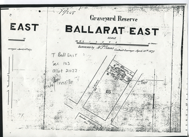
Digital photograph, Graveyard Reserve, Ballarat East
Ballarat East, Section 103, Allotment 21 & 22, Peake and Tress Streets, Mount Pleasant. Surveyed by W. S. Reeves Contract Surveyor April 14th, 1871. Also shows allotments of T. Williams and F. Macalpin, as well as the Powder Magazine Reserve.Plan of the Graveyard Reserve and Mount Pleasant Powder Magazine.mount pleasant, w.s. reeves, plan, powder magazine, t. williams, f. macalpin -
 Ballarat Heritage Services
digital copy, Surveyor's Notebook Ballarat East, 24 August 1858
Survey of land in Ballarat East in August 1858 showing hotels and tents etc. Images from Bellair's surveyor's book.eugene bellair, surveying, surveyor, eureka stockade -
Hume City Civic Collection
Map, Sunbury Township 1857
This is a reprint of a 1857 map of the township of Sunbury in the County of Bourke produced by the Public Records Office by courtesy of the Surveyor General in 1978.This is a reprint of a 1857 map of the township of Sunbury.sunbury, shire of bulla, sunbury township, 1850s -
 Bendigo Historical Society Inc.
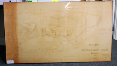
Map - CONTOUR PLAN OF THE GOVERNMENT CAMP SANDHURST 1854, 1994
Contour map (copy) of the Government Camp Sandhurst, 1854. Map is mounted on coreflute and laminated. Written in bottom righthand corner 'Contour Plan of the Government Camp, Sandhurst. Dec 1854. Signed by Richard Larritt, Assistant Surveyor, 11th December 1854.' Shown on map: Pall Mall, Bendigo Creek, Commissioner's Gully, View Place (now View Street), Post Office, Bank of Victoria, District Surgeon, Sandhurst Fire Brigade, Police Hospital, Flagstaff, Gold Office, License Shed, Military Barracks, Stables, Commissioner's Buildings, Police Office. Old Cemetery, Garden. Reference on righthand side: 'Stone or brick buildings are tinted in crimson. Wooden buildings tinted in Indian Ink. Tents and other temporary structures tinted in Burnt Sienna.' Scale of Chains, on bottom of map. Sticker on bottom left hand corner and back of map ' Presented by Survey and Mapping, Victoria, 7th Octber, 1994'.map, bendigo, government camp, pall mall, bendigo creek, commissioner's gully, view place (now view street), post office, bank of victoria, district surgeon, sandhurst fire brigade, police hospital, flagstaff, gold office, license shed, military barracks, stables, commissioner's buildings, police office. old cemetery, garden. , survey and mapping victoria. sandhurst, bendigo. -
 Kew Historical Society Inc
Plan, Melbourne & Metropolitan Board of Works : Borough of Kew : Detail Plan No.1588, 1904
The Melbourne and Metropolitan Board of Works (MMBW) plans were produced from the 1890s to the 1950s. They were crucial to the design and development of Melbourne's sewerage and drainage system. The plans, at a scale of 40 feet to 1 inch (1:480), provide a detailed historical record of Melbourne streetscapes and environmental features. Each plan covers one or two street blocks (roughly six streets), showing details of buildings, including garden layouts and ownership boundaries, and features such as laneways, drains, bridges, parks, municipal boundaries and other prominent landmarks as they existed at the time each plan was produced. (Source: State Library of Victoria)This plan forms part of a large group of MMBW plans and maps that was donated to the Society by the Mr Poulter, City Engineer of the City of Kew in 1989. Within this collection, thirty-five hand-coloured plans, backed with linen, are of statewide significance as they include annotations that provide details of construction materials used in buildings in the first decade of the 20th century as well as additional information about land ownership and usage. The copies in the Public Record Office Victoria and the State Library of Victoria are monochrome versions which do not denote building materials so that the maps in this collection are invaluable and unique tools for researchers and heritage consultants. A number of the plans are not held in the collection of the State Library of Victoria so they have the additional attribute of rarity.Original survey plan, issued by the MMBW to a contractor with responsibility for constructing sewers in the area identified on the plan within the Borough of Kew. The plan was at some stage hand-coloured, possibly by the contractor, but more likely by officers working in the Engineering Department of the Borough and later Town, then City of Kew. The hand-coloured sections of buildings on the plan were used to denote masonry or brick constructions (pink), weatherboard constructions (yellow), and public buildings (grey). This plan shows the original configuration of the Kew Post Office, Court House and Police Station, which had opened in 1888. This configuration was to essentially remain until the purchase of the Court House and Police Station by the City of Boroondara in 2007 and its subsequent renovation. Interestingly, the MMBW surveyors incorrectly labelled parts of the complex. In the triangle in front of the Post Office, before the erection of the Kew Cenotaph in 1925, was located a lawn and the Queen Victoria Jubilee Fountain. While many of the shops on the south side of High street had been constructed by 1903 a number of sites were still used as vegetable gardens. Further along High Street, on the corner of Charles Street, the Salvation Army Barracks can be seen on the plan. These Barracks predate the later Citadel and ‘Young People’s Hall’ that were opened in 1919. At 22 Charles Street can be seen the house of James Venn Morgan. Hailed as the ‘father of Kew’, Morgan arrived in Melbourne in 1840. He was first engaged as a bookmaker, but a fortunate venture on the goldfields enabled him to purchase land in Kew. He conducted a market garden and dairy in Kew for many years.melbourne and metropolitan board of works, detail plans, maps - borough of kew, mmbw 1588, cartography -
 Kew Historical Society Inc
Photograph - Brick and Stucco Bungalow, J E Barnes, c.1920
The Kew Historical Society's map collection includes a substantial number of real estate subdivision plans, mainly of Kew but also of surrounding suburbs in Melbourne. Most of the subdivision plans date from the 1920s and 1930s when the districts old homes and local farmland were being split up to accommodate residential growth in the postwar period. These early plans were assembled by a local firm, Jas R Mather & McMillan, which had an office in Cotham Road. Many of the plans, and sometimes photos, were annotated by the agents.Subdivision plans are historically important documents used as evidence for the growth of suburbs in Australia. They frequently provide information about when the land was sold as well as evidence relating to surveyors and real estate and financial agents. The numerous subdivision plans in the Kew Historical Society's collection represent working documents, ranging from the initial sketches made in planning a subdivision to printed plans on which auctioneers or agents listed the prices for which individual lots were sold. In a number of cases, the reverse of a subdivision plan in the collection includes a photograph of a house that was also for sale by the agent. These photographs provide significant heritage information relating house design and decoration, fencing and household gardens.The photograph may also be aesthetically significant depending o the importance of the photographic atelier.Real estate photograph for a local agent by the Kew photographer, Josiah Earl Barnes. The photo is of a weatherboard or brick rendered bungalow with a twisted wire fence. Given Barnes' status a a Kew photographer, the house is probably locate din Kew or East Kew. Unfortunately the handwritten information on the mount bordering the photo is damaged and cannot be read. The bungalow has a gabled, tiled roof with terra cotta finials at the front of both gables. The house has a central doorway, framed by a pseudo portico supported by four wooden columns. On each side of the doorway, at the front, there are paired sash windows, which, like the half-timbered gable, are picked out in a darker colour.Handwritten, mostly illegible description by selling agent on mount surround: " .... in Diningroom, Drawing Rooms, ... Photographers details printed on mount: "J. E. Barnes / Photo / Phone 1966 Haw KEW"houses - kew, bungalows - kew, real estate photographs, j.e. barnes -- photographer -
 Kew Historical Society Inc
Photograph - Victorian Double-fronted Brock Villa, Cotham Road, c. 1919
The Kew Historical Society's map collection includes a substantial number of real estate subdivision plans, mainly of Kew but also of surrounding suburbs in Melbourne. Most of the subdivision plans date from the 1920s and 1930s when the districts old homes and local farmland were being split up to accommodate residential growth in the postwar period. These early plans were assembled by a local firm, Jas R Mather & McMillan, which had an office in Cotham Road. Many of the plans, and sometimes photos, were annotated by the agents.Subdivision plans are historically important documents used as evidence for the growth of suburbs in Australia. They frequently provide information about when the land was sold as well as evidence relating to surveyors and real estate and financial agents. The numerous subdivision plans in the Kew Historical Society's collection represent working documents, ranging from the initial sketches made in planning a subdivision to printed plans on which auctioneers or agents listed the prices for which individual lots were sold. In a number of cases, the reverse of a subdivision plan in the collection includes a photograph of a house that was also for sale by the agent. These photographs provide significant heritage information relating house design and decoration, fencing and household gardens.The photograph may also be aesthetically significant depending o the importance of the photographic atelier.Real estate photographs of a classic double-fronted late Victorian brick villa. It central location in Cotham Road, Kew enabled the selling agent to note its proximity to the tram. With seven rooms, all ‘modern conveniences’, and land of 66×167, the house was to be sold for £1100. The villa has a number of interesting features including a pattern within the slate roof as well as the use of polychrome brickwork under the eaves and on the façade. The intricacy of the cast iron lace is emphasised by the line of projecting wooden blocks above it. The picket gate is painted a different colour to the pickets of the fence. The house has a name (illegible) that is attached to the inset cast iron lace of the central projecting gable in the veranda. Stamped on mount: "Kew. Central. Close tram. / Comfortable Brick Villa. / Containing 7 rooms / Modern conveniences: / Land 66 x 167. Sold 1100 pounds:"houses - kew, victorian villas, real estate photographs, cotham road - kew -
 Kew Historical Society Inc
Photograph - Double-fronted Edwardian Villa, c.1918
The Kew Historical Society's map collection includes a substantial number of real estate subdivision plans, mainly of Kew but also of surrounding suburbs in Melbourne. Most of the subdivision plans date from the 1920s and 1930s when the districts old homes and local farmland were being split up to accommodate residential growth in the postwar period. These early plans were assembled by a local firm, Jas R Mather & McMillan, which had an office in Cotham Road. Many of the plans, and sometimes photos, were annotated by the agents.Subdivision plans are historically important documents used as evidence for the growth of suburbs in Australia. They frequently provide information about when the land was sold as well as evidence relating to surveyors and real estate and financial agents. The numerous subdivision plans in the Kew Historical Society's collection represent working documents, ranging from the initial sketches made in planning a subdivision to printed plans on which auctioneers or agents listed the prices for which individual lots were sold. In a number of cases, the reverse of a subdivision plan in the collection includes a photograph of a house that was also for sale by the agent. These photographs provide significant heritage information relating house design and decoration, fencing and household gardens.The photograph may also be aesthetically significant depending on the importance of the photographic atelier.On the reverse of a subdivision plan of the Palmyra Estate (Kew) is a photograph of a double-fronted Edwardian villa. The weatherboard and stucco house with high brick chimneys provides a clear indication of the style of curtains and gardens in houses of the period. Holland blinds with lace inserts are used in the left front window. They are combined with long lace curtains. The garden, with its curved pathway is bordered with garden beds that include marguerite daisies and roses. Reflecting a new interest in the Australian landscape, tree ferns and ground ferns are planted closer to the house.houses - kew, architecture - edwardian, real estate photographs -
 Kew Historical Society Inc
Plan - Subdivision : Cotham and Glenferrie Roads, J R Mathers & McMillan
The Kew Historical Society's map collection includes a substantial number of real estate subdivision plans, mainly of Kew but also of surrounding suburbs in Melbourne. Most of the subdivision plans date from the 1920s and 1930s when the districts old homes and local farmland were being split up to accommodate residential growth in the postwar period. These early plans were assembled by a local firm, Jas R Mather & McMillan, which had an office in Cotham Road. Many of the plans, and sometimes photos, were annotated by the agents.Subdivision plans are historically important documents used as evidence for the growth of suburbs in Australia. They frequently provide information about when the land was sold as well as evidence relating to surveyors and real estate and financial agents. The numerous subdivision plans in the Kew Historical Society's collection represent working documents, ranging from the initial sketches made in planning a subdivision to printed plans on which auctioneers or agents listed the prices for which individual lots were sold. In a number of cases, the reverse of a subdivision plan in the collection includes a photograph of a house that was also for sale by the agent. These photographs provide significant heritage information relating house design and decoration, fencing and household gardens.The photograph may also be aesthetically significant depending on the importance of the photographic atelier.An undated and untitled hand-drawn and coloured subdivision plan detailing the boundaries of a number of irregular allotments bordering Cotham Road, Glenferrie Road and Stirling Avenue (now Stirling Street). The plan predates the actual subdivision that led to the creation of the eight commercial properties occupying 118-132 Cotham Road. The plan may represent an old subdivision that was further subdivided at a later date, or it may be a subdivision that never eventuated. On MMBW Detail Plan 1575 (1903), the area represented by the proposed subdivision was residential rather than commercial. The irregularity of lots is also apparent in the MMBW Plan. The largest of the unnumbered blocks on the hand-drawn subdivision plan may relate to the boundaries of the nineteenth century mansion identified as ‘Kelso’ on the MMBW Plan.subdivision plans - kew, cotham road - kew,, glenferrie road - kew , stirling avenue street - kew -
 Kew Historical Society Inc
Photograph - Cottage, probably East Kew, A. Aberline, 1920s
The Kew Historical Society's map collection includes a substantial number of real estate subdivision plans, mainly of Kew but also of surrounding suburbs in Melbourne. Most of the subdivision plans date from the 1920s and 1930s when the districts old homes and local farmland were being split up to accommodate residential growth in the postwar period. These early plans were assembled by a local firm, Jas R Mather & McMillan, which had an office in Cotham Road. Many of the plans, and sometimes photos, were annotated by the agents.Subdivision plans are historically important documents used as evidence for the growth of suburbs in Australia. They frequently provide information about when the land was sold as well as evidence relating to surveyors and real estate and financial agents. The numerous subdivision plans in the Kew Historical Society's collection represent working documents, ranging from the initial sketches made in planning a subdivision to printed plans on which auctioneers or agents listed the prices for which individual lots were sold. In a number of cases, the reverse of a subdivision plan in the collection includes a photograph of a house that was also for sale by the agent. These photographs provide significant heritage information relating house design and decoration, fencing and household gardens.The photograph may also be aesthetically significant depending on the importance of the photographic atelier.An elevated, modest weatherboard house, photographed towards the end of the construction phase. The lower section of the weatherboards are exposed and stained. The upper section is rendered with rough-cast. The tiled roof has a single gable that extends over the centrally placed front porch. On the porch, the door and single sidelight are filled with coloured leadlight whereas the casement windows in the front rooms contain plain glass. The leadlight and the wrought iron of the verandah are the only decorative elements of the utilitarian design. The location of the house, which was advertised for sale, has not to date been identified. The real estate photograph is mounted on the reverse of a subdivision plan for the Harvest Home Estate, Kew East.Photographer's stamp, lower right on mount: "A. Aberline, Glenferrie"houses - kew, bungalows - kew, real estate photographs -
 Kew Historical Society Inc
Photograph - Bungalow, probably East Kew, 1920s
The Kew Historical Society's map collection includes a substantial number of real estate subdivision plans, mainly of Kew but also of surrounding suburbs in Melbourne. Most of the subdivision plans date from the 1920s and 1930s when the districts old homes and local farmland were being split up to accommodate residential growth in the postwar period. These early plans were assembled by a local firm, Jas R Mather & McMillan, which had an office in Cotham Road. Many of the plans, and sometimes photos, were annotated by the agents.Subdivision plans are historically important documents used as evidence for the growth of suburbs in Australia. They frequently provide information about when the land was sold as well as evidence relating to surveyors and real estate and financial agents. The numerous subdivision plans in the Kew Historical Society's collection represent working documents, ranging from the initial sketches made in planning a subdivision to printed plans on which auctioneers or agents listed the prices for which individual lots were sold. In a number of cases, the reverse of a subdivision plan in the collection includes a photograph of a house that was also for sale by the agent. These photographs provide significant heritage information relating house design and decoration, fencing and household gardens.The photograph may also be aesthetically significant depending on the importance of the photographic atelier.An unusual bungalow that does not conform to a particular architectural style but which contains eclectic elements of the style of varying periods. The most striking element of the design is the cantilevered veranda that is supported by heavy chains that are attached to the central gable. This deep gable extends across most of the façade, forming an extensive veranda. Parts of this are infilled with screens. Seven wooden posts, whose lower halves are encased in rendered brick pillars, support this gabled veranda. The roof would appear to be covered with corrugated iron. The location of the house, which was advertised for sale, has to date not been identified. The real estate photo is on the reverse of a plan for the Myrtle Hill Subdivision, Kew.bungalows - kew, architecture - 1920s, real estate photographs -
 Kew Historical Society Inc
Plan - Subdivision Plan, J R Mathers & McMillan, Myrtle Hill Estate, East Kew, circa 1949, c.1949
The Kew Historical Society's map collection includes a substantial number of real estate subdivision plans, mainly of Kew but also of surrounding suburbs in Melbourne. Most of the subdivision plans date from the 1920s and 1930s when the districts old homes and local farmland were being split up to accommodate residential growth in the postwar period. These early plans were assembled by a local firm, Jas R Mather & McMillan, which had an office in Cotham Road. Many of the plans, and sometimes photos, were annotated by the agents.Subdivision plans are historically important documents used as evidence for the growth of suburbs in Australia. They frequently provide information about when the land was sold as well as evidence relating to surveyors and real estate and financial agents. The numerous subdivision plans in the Kew Historical Society's collection represent working documents, ranging from the initial sketches made in planning a subdivision to printed plans on which auctioneers or agents listed the prices for which individual lots were sold. In a number of cases, the reverse of a subdivision plan in the collection includes a photograph of a house that was also for sale by the agent. These photographs provide significant heritage information relating house design and decoration, fencing and household gardens.The photograph may also be aesthetically significant depending on the importance of the photographic atelier.Myrtle Hill, at 14 Vista Avenue, Kew, is of local historical and architectural significance as a good example of a large and imposing single-storey Italianate house of the early 1870s surviving in Kew. Originally sited on a large allotment overlooking Normanby Road, the setting of the house has been dramatically altered through extensive subdivision and development. The subdivision plan of the ‘Myrtle Hill Estate’ indicates that in one such subdivision, 11 allotments were created fronting Bowyer Avenue, Myrtle Avenue, and Normanby Road. The outline and building profile of Myrtle Hill is shown on the west side of Bowyer Avenue.The full (typed) title of this subdivision plan is :"Plan of SUBDIVISION of part of CROWN PORTION 83. / at KEW / PARISH OF BOROONDARA. / COUNTY OF BOURKE". / "MYRTLE HILL ESTATE / EAST KEW" In addition to the Title and subtitle, the plan also lists the advantages of the subdivision. -
 Kew Historical Society Inc
Plan - Subdivision Plan, J R Mathers & McMillan, Normanby Estate, c.1913
The Kew Historical Society's map collection includes a substantial number of real estate subdivision plans, mainly of Kew but also of surrounding suburbs in Melbourne. Most of the subdivision plans date from the 1920s and 1930s when the districts old homes and local farmland were being split up to accommodate residential growth in the postwar period. These early plans were assembled by a local firm, Jas R Mather & McMillan, which had an office in Cotham Road. Many of the plans, and sometimes photos, were annotated by the agents.Subdivision plans are historically important documents used as evidence for the growth of suburbs in Australia. They frequently provide information about when the land was sold as well as evidence relating to surveyors and real estate and financial agents. The numerous subdivision plans in the Kew Historical Society's collection represent working documents, ranging from the initial sketches made in planning a subdivision to printed plans on which auctioneers or agents listed the prices for which individual lots were sold. In a number of cases, the reverse of a subdivision plan in the collection includes a photograph of a house that was also for sale by the agent. These photographs provide significant heritage information relating house design and decoration, fencing and household gardens.The photograph may also be aesthetically significant depending on the importance of the photographic atelier.The Normanby Estate, which was adjacent to Normanby Road, Kew East, included thirty-one lots for sale. Streets on the subdivision plan include Adeney Avenue, Park Hill Road, Normanby Road, Weir Street and Wharton Street. Cotham Road and its tramway are shown nearby. The plan is interesting as it shows Wharton Street, named after the architect and town planner George Wharton, who was the first chairman of the Municipality of Kew. The street was to later be renamed Cecil Street. Also shown are proposed ‘Municipal Gardens’ where Parkhill Drive is now located."D" in top left corner. Stamped auctioneers contact details: "Jas. R. Mathers & Son & McMillan / Auctioneer & Land Salesmen, / 271 Collins Street / Melbourne" and Jas. R. Mathers / Estate & Financial Agent / Cotham Road / Kew".weir street - kew, wharton street - kew, normanby road - kew, cotham road - kew, municipal gardens - kew, park hill parkhill road - kew, braemar - kew, subdivision plans - kew -
 Kew Historical Society Inc
Plan, J R Mathers & McMillan, Sackville, Thomas & Lytton Streets, Kew, Twentieth Century
The Kew Historical Society's map collection includes a substantial number of real estate subdivision plans, mainly of Kew but also of surrounding suburbs in Melbourne. Most of the subdivision plans date from the 1920s and 1930s when the districts old homes and local farmland were being split up to accommodate residential growth in the postwar period. These early plans were assembled by a local firm, Jas R Mather & McMillan, which had an office in Cotham Road. Many of the plans, and sometimes photos, were annotated by the agents.Subdivision plans are historically important documents used as evidence for the growth of suburbs in Australia. They frequently provide information about when the land was sold as well as evidence relating to surveyors and real estate and financial agents. The numerous subdivision plans in the Kew Historical Society's collection represent working documents, ranging from the initial sketches made in planning a subdivision to printed plans on which auctioneers or agents listed the prices for which individual lots were sold. In a number of cases, the reverse of a subdivision plan in the collection includes a photograph of a house that was also for sale by the agent. These photographs provide significant heritage information relating house design and decoration, fencing and household gardens.The photograph may also be aesthetically significant depending on the importance of the photographic atelier.Lithographed subdivision plan for an un-named estate with 28 allotments facing Lytton, Sackville and Thomas Streets in Kew. The land would have originally formed part of the Dumaresq Estate. subdivision plans - kew, lytton street, sackville street, thomas street - kew -
 Kew Historical Society Inc
Plan - Subdivision Plan, Jas R Mathers Son & McMillan, Eastlawn Estate : East Kew Auction Sale, 1914
The Kew Historical Society's map collection includes a substantial number of real estate subdivision plans, mainly of Kew but also of surrounding suburbs in Melbourne. Most of the subdivision plans date from the 1920s and 1930s when the districts old homes and local farmland were being split up to accommodate residential growth in the postwar period. These early plans were assembled by a local firm, Jas R Mather & McMillan, which had an office in Cotham Road. Many of the plans, and sometimes photos, were annotated by the agents.Subdivision plans are historically important documents used as evidence for the growth of suburbs in Australia. They frequently provide information about when the land was sold as well as evidence relating to surveyors and real estate and financial agents. The numerous subdivision plans in the Kew Historical Society's collection represent working documents, ranging from the initial sketches made in planning a subdivision to printed plans on which auctioneers or agents listed the prices for which individual lots were sold. In a number of cases, the reverse of a subdivision plan in the collection includes a photograph of a house that was also for sale by the agent. These photographs provide significant heritage information relating house design and decoration, fencing and household gardens.The photograph may also be aesthetically significant depending on the importance of the photographic atelier.The ‘Eastlawn Estate’ was surveyed and ready for auction in March 1914, three months before the outbreak of World War I. Sixty-six allotments, created on the ‘order of Mr & Miss Preston’ surrounded the mansion of Woodlands in Harp Road. Woodlands formed part of the Estate, being advertised as lot 1. The allotments faced High, Station and Wright Streets, Harp and Normanby Roads, and Woodlands Avenue. Pru Sanderson in the Kew Conservation Study (Vol.2, 1988) wrote that the Eastlawn Estate ‘covered the western half of the failed Harp of Erin Estate’. Contemporary advertisements promoted the Eastlawn Estate as: ‘There will be no more convenient district nor pleasant Suburb than East Kew for the busy business man. When the Electric Tram is laid, he will be able to journey quickly and pleasantly direct from Collins Street to his home in the Eastlawn Estate in about 20 minutes’. The actual plans of subdivision were included in advertisements in The Argus and in the local newspapers."C" top left. Various annotations.subdivision plans - kew, station street, normanby road, high street, woodlands avenue, harp road, woodlands - kew -
 Kew Historical Society Inc
Plan - Subdivision Plan, Winton Estate, East Kew : Sale of 10 Building Blocks, 1920
The Kew Historical Society's map collection includes a substantial number of real estate subdivision plans, mainly of Kew but also of surrounding suburbs in Melbourne. Most of the subdivision plans date from the 1920s and 1930s when the districts old homes and local farmland were being split up to accommodate residential growth in the postwar period. These early plans were assembled by a local firm, Jas R Mather & McMillan, which had an office in Cotham Road. Many of the plans, and sometimes photos, were annotated by the agents.Subdivision plans are historically important documents used as evidence for the growth of suburbs in Australia. They frequently provide information about when the land was sold as well as evidence relating to surveyors and real estate and financial agents. The numerous subdivision plans in the Kew Historical Society's collection represent working documents, ranging from the initial sketches made in planning a subdivision to printed plans on which auctioneers or agents listed the prices for which individual lots were sold. In a number of cases, the reverse of a subdivision plan in the collection includes a photograph of a house that was also for sale by the agent. These photographs provide significant heritage information relating house design and decoration, fencing and household gardens.The photograph may also be aesthetically significant depending on the importance of the photographic atelier.Subdivision plan for the so-called Winton Estate in East Kew. The Estate comprised 10 lots facing Simpson Street and Campbell Street. The estate was auctioned by Jas. R. Mathers, Son and McMillan. campbell street, simpson street, hunter street, normanby road - kew, subdivision plans - east kew, subdivision plans - kew -
![7 Roomed Brick [villa]; Modern Conveniences](/media/collectors/550653872162f11fb04854aa/items/59ec3da221ea690fdc4ba793/item-media/59ec3ee521ea690fdc4d0c37/item-fit-380x285.jpg) Kew Historical Society Inc
Kew Historical Society IncPhotograph - 7 Roomed Brick [villa]; Modern Conveniences, 1920s
The Kew Historical Society's map collection includes a substantial number of real estate subdivision plans, mainly of Kew but also of surrounding suburbs in Melbourne. Most of the subdivision plans date from the 1920s and 1930s when the districts old homes and local farmland were being split up to accommodate residential growth in the postwar period. These early plans were assembled by a local firm, Jas R Mather & McMillan, which had an office in Cotham Road. Many of the plans, and sometimes photos, were annotated by the agents.Subdivision plans are historically important documents used as evidence for the growth of suburbs in Australia. They frequently provide information about when the land was sold as well as evidence relating to surveyors and real estate and financial agents. The numerous subdivision plans in the Kew Historical Society's collection represent working documents, ranging from the initial sketches made in planning a subdivision to printed plans on which auctioneers or agents listed the prices for which individual lots were sold. In a number of cases, the reverse of a subdivision plan in the collection includes a photograph of a house that was also for sale by the agent. These photographs provide significant heritage information relating house design and decoration, fencing and household gardens.The photograph may also be aesthetically significant depending on the importance of the photographic atelier.A professionally produced photograph for a local real estate agent, probably Jas. R. Mathers, Son & McMillan. The photograph is of a Federation-era bungalow, in Kew. The photo is on the reverse of a subdivision plan for the Normanby Heights Estate, Kew.The mount on which the photograph is placed includes: "Kew. 1 minute to tram. Good Position. / 7 roomed brick. Modern conveniences. / Land 60 x 135. 1100 pounds"real estate photographs, houses - kew, federation architecture -
 Kew Historical Society Inc
Plan - Subdivision Plan, Argyle Road, Heather Grove, Victor Avenue, Kew, c.1937
The Kew Historical Society's map collection includes a substantial number of real estate subdivision plans, mainly of Kew but also of surrounding suburbs in Melbourne. Most of the subdivision plans date from the 1920s and 1930s when the districts old homes and local farmland were being split up to accommodate residential growth in the postwar period. These early plans were assembled by a local firm, Jas R Mather & McMillan, which had an office in Cotham Road. Many of the plans, and sometimes photos, were annotated by the agents.Subdivision plans are historically important documents used as evidence for the growth of suburbs in Australia. They frequently provide information about when the land was sold as well as evidence relating to surveyors and real estate and financial agents. The numerous subdivision plans in the Kew Historical Society's collection represent working documents, ranging from the initial sketches made in planning a subdivision to printed plans on which auctioneers or agents listed the prices for which individual lots were sold. In a number of cases, the reverse of a subdivision plan in the collection includes a photograph of a house that was also for sale by the agent. These photographs provide significant heritage information relating house design and decoration, fencing and household gardens.The photograph may also be aesthetically significant depending on the importance of the photographic atelier.Undated blue subdivision plan in Kew of 14 lots facing Argyle Road, Heather Grove and Victor Road. The Plan identifies Tuxen & Miller as the surveyors. [Formerly catalogued as MAP.0059]subdivision plans - kew, argyle road - kew, heather grove - kew, victor avenue - kew -
 Queen Victoria Women's Centre
Photograph, c.1995/1996
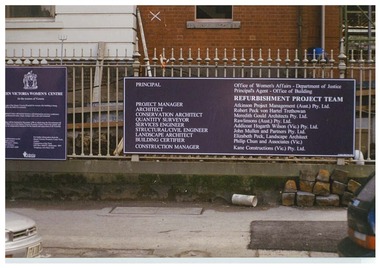
Colour photograph. The board which was outside the QVWC building's gates on Lonsdale street. which details main groups involved in refurbishment of the building. "Principle: Office of Women's Affairs - Department of Justice. Principle Agent - Office of Building. Refurbishment Project Team. Project manager: Atkinson Project Management (Aust.) Pty. Ltd. Architects: Robert Peck won Hartel Trethowan. Conservation Architect: Meredith Gould Architects Pty. Ltd. Quantity Surveyor: Rawlinsons (Aust.) Pty. Ltd. Services Engineer: Addicoat Hogarth WIlson (Vic) Pty. Ltd. Structural/Civil Engineer: John Mulle and Partners Pty. Ltd. Landscape Architect: Elizabeth Peck, Landscape Architect. Building Certifier: Philip Chun and Associates (Vic.) Construction Manager: Kane Constructions (Vic.) Pty. Ltd."historic buildings, building construction -
 Surrey Hills Historical Society Collection
Photograph, Harley Tarrant and his 1905 Tarrant car, 1905
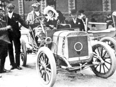
Col. Harley Tarrant was an astute businessman and a part-time soldier. He was born at Clunes in 1860 and as a young man worked with an engineering firm in Sydney. He later joined the Board of Works in Melbourne. and later entered the early car manufacturing and retailing trade. In 1905 Harley Tarrant built the first car to be built and sold in Australia. For a time he was a surveyor and worked in Surrey Hills but motoring became his prime interest. In the early 1890s he set up a workshop in what was then Post Office Place, Melbourne. He built stationary engines which ran on kerosene and in the first years of the twentieth century, with partner W Howard Lewis, built the first petrol driven car in Australia. This photo is of his sixth car and was taken after the finish of the 1st Sydney to Melbourne Dunlop Reliability Trial, which Tarrant won. Harley Tarrant produced cars between 1901 and 1907 at the Tarrant Motor and Engineering Company in Queen's Bridge Street, South Melbourne. The first car had a rear-mounted two-horse power Benz engine. Two-cylinder models were later produced followed by 4-cylinder models. The only Tarrant car in existence in 1984 was owned by Harley Tarrant's grandsons, Kenneth and Peter Holmes of Melbourne. The 1906 Tarrant car featured on an Australia Post stamp in 1984. It was one of a series of 5 stamps featuring Australian veteran and vintage cars.Black and white photo of a car without a hood in the driver's seat of which is a man with cap, driving dust coat and goggles, identified as Harley Tarrant. Beside him is a young girl in a large frilly; she is identified as Doreen Tarrant, his daughter. Another man with cap and goggles is talking to him and a gentleman in a bowler hat looks on. There is a women and 2 children in the background in front of a large brick wall decorated in two coloured bricks. cars, inventions, dunlop reliability trial, tarrant motor and engineering company, mr harley tarrant, miss doreen tarrant, mrs doreen holmes, col harley tarrant -
University of Melbourne, Burnley Campus Archives
Map (item), Proposed Reserve for Horticultural & Experimental Garden in the Survey Paddock. Clement Hodgkinson Deputy Surveyor General, 1862
horticultural & experimental garden, survey paddock, clement hodgkinson