Showing 70 items matching "tree of the month"
-
 Eltham District Historical Society Inc
Photograph - Digital Photograph, Alan King, Panton Hill Primary School, 27 March 2008
The Panton Hill Primary School building, which has served the community since 1889, was not the area's first. Kingston School (an early name for Panton Hill) opened in May 1865. This was replaced in 1871 when the Panton Hill School number 1134 opened and in 1874 the school moved to its current location [September 2023] where many additions and renovations have taken place to meet the needs of local children in the 21st century. Covered under Heritage Overlay, Nillumbik Planning Scheme. Published: Nillumbik Now and Then / Marguerite Marshall 2008; photographs Alan King with Marguerite Marshall.; p63 The Panton Hill Primary School building, which has served the community since 1889, was not the area’s first. In 1871 Henry Edelman opened a Common School in a paling-clad hut, replacing the Kingstown No 786 school. The two-acre (0.8ha) site of crown land had previously been held under Miners Right. In 1875 the Education Department bought a building on the main road for State School No 1134, for £200 and remodelled it as a school.4 Panton Hill had as one of its teachers, Frank Tate, who was to become one of Victoria’s most influential educational reformers. It was his first school, when he began teaching on January 22, 1884, as a 20 year old.5 The following month Robert J Harris was appointed to the school and remained as head teacher until his death in 1887. His son R C Harris was apprenticed to Mr Rossiter, editor of the first local paper. The Evelyn Observer, first published in 1873. Harris later bought the newspaper which remained a family business until the 1920s. J Hughes of Cherry Tree Road succeeded Harris as teacher at Panton Hill and sold his land for the school site. Though now unrecognisable, the school building includes the classroom of the last Smiths Gully State School No 1737, which was built in 1882, and moved to Panton Hill in 1894. From 1922 each school day began with the ringing of the bell, which is still in its stand, and is an unusually old memorial of this kind. To accommodate the growing population, the building was remodelled, with additions in 1923 and classrooms were added in 1955, 1963 and 1970. The former teacher’s residence is the only surviving 19th century dwelling in the centre of Panton Hill, and is now used as part of the school. The residence was originally rectangular but is now L-shaped. Similar weatherboard State School buildings in the shire from this period are the Kangaroo Ground and the St Andrews Primary Schools. All were standard Education Department/Public Works Department designs.This collection of almost 130 photos about places and people within the Shire of Nillumbik, an urban and rural municipality in Melbourne's north, contributes to an understanding of the history of the Shire. Published in 2008 immediately prior to the Black Saturday bushfires of February 7, 2009, it documents sites that were impacted, and in some cases destroyed by the fires. It includes photographs taken especially for the publication, creating a unique time capsule representing the Shire in the early 21st century. It remains the most recent comprehenesive publication devoted to the Shire's history connecting local residents to the past. nillumbik now and then (marshall-king) collection, panton hill primary school -
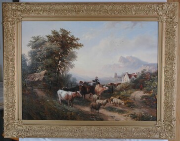 Glenelg Shire Council Cultural Collection
Painting, W.V. Tippel (?), English Farm Scene, 1853
Unknown. "Item of the Month", 2006 (Jan-July) - on display in Council Foyer (Portland Office).Scene of a man herding cattle and sheep down a country lane. To the left is a wooden pole fence and trees edging the road. On right, a path curves up and behind bushes. A man in a red coat is walking at the end of this path with his back to the viewer. In mid-ground on right is a white, thatched roof building and a church is evident behind it. In background are mountains, painted in rose and violet. Clouds sweep across the sky and mist fills the valley in front of the mountains. Framed in ornate gold-painted frame.Front: (no inscriptions evident) Back: Conservation Centre label. From previous Worksheet: W.V. Tippel, 1853. Jefferson, Artists Colours, Crystal House Baths, BRISTOL (stamp). -
 Eltham District Historical Society Inc
Photograph - Digital Photograph, Marguerite Marshall, Jesse Tree playing the Didgeridoo and Swiss Hang Drum at St Andrews Market, 29 March 2008
Published: Nillumbik Now and Then / Marguerite Marshall 2008; photographs Alan King with Marguerite Marshall.; p175 It’s Saturday morning and thousands of people are visiting St Andrews Market at the corner of Heidelberg-Kinglake Road and Proctor Street. It’s hard to find a park. Cars are banked up along the narrow road and crammed in a nearby parking area. Yet, at the market, people look relaxed and happy amongst the yellow box gums on the site where the Wurundjeri people used to gather. Stone artefacts unearthed there by Koorie researcher, Isabel Ellender, indicate the site was once a Wurundjeri meeting place, according to Aboriginal Affairs Victoria. Acoustic sounds mingle with quiet conversations. A guitarist blows a mouth organ while his bare toes tickle chimes. A tiny busker, perhaps five years old, plays a violin while sounds of a harp emerge from the hall. One stallholder, selling delicious-looking pastries, chats to another in Spanish, then to me in broad Australian. ‘I was born in Fitzroy but my mother came from Mexico and my dad from Serbia,’ she smiles. A New Zealander fell in love with Mongolia and now imports their hand-made embroidered clothes and Yurts (tents) and runs adventure tours. A young woman visited Morocco and when friends admired the shoes she bought, she decided to import them and sell them at the market. Oxfam sells Fair Trade toys and clothes and displays a petition to Make Poverty History. Other stalls sell Himalayan salt, jewellery made from seeds from northern Australia, glass paper-weights from China as well as locally grown vegetables, flowers and organic freshly baked bread. A woman sits in a state of bliss under the hands of a masseur. Another offers Reiki or spiritual healing. A juggler tosses devil sticks – ‘not really about the devil,’ he smiles. This skill was practised thousands of years ago in Egypt and South America he says. At the Chai Tent people lounge on cushions in leisurely conversation. The idea for the market was first mooted among friends over a meal at the home of famous jazz and gospel singer Judy Jacques.2 Jacques remembers a discussion with several local artists including Marlene Pugh, Eric Beach, Les Kossatz, Ray Newell and Peter Wallace. ‘We decided we wanted a meeting place, where all the different factions of locals could meet on common ground, sell their goodies and get to know one another,’ Jacques recalls. They chose the site opposite another meeting place, St Andrews Pub. A week later Jacques rode her horse around the district and encouraged her neighbours to come along to the site to buy or sell. On February 23, 1973, about 20 stallholders arrived with tables. They traded ‘second-hand clothes, vegetables, meat, cheese, eggs, chickens, goats, scones, tea, garden pots and peacock feathers’. Now around 2000 people visit each Saturday. People usually linger until dusk. The market – with around 150 stalls of wares from a wide variety of cultures – stands alongside Montsalvat as the most popular tourist attraction in Nillumbik. By the 1990s St Andrews Market was in danger of being loved to death, as the site was becoming seriously degraded. The market was spreading in all directions and the degradation with it. A local council arborist’s report in 1994 noted exposed tree roots from erosion and compaction. The Department of Sustainability and Environment threatened to close the market if the degradation was not rectified. After many months of research, discussions and lobbying by a few residents, the council formed a Committee of Management, with an Advisory Committee, and introduced an Environment Levy. The State Government, the council and the market, funded terracing of the site to stop erosion, and retain moisture and nutrients. Vehicles were excluded from some sensitive areas and other crucial zones reserved for re-vegetation. Volunteers planted more than 3000 locally grown indigenous species. The old Yellow Box trees fully recovered and are expected to give shade for many years to come.This collection of almost 130 photos about places and people within the Shire of Nillumbik, an urban and rural municipality in Melbourne's north, contributes to an understanding of the history of the Shire. Published in 2008 immediately prior to the Black Saturday bushfires of February 7, 2009, it documents sites that were impacted, and in some cases destroyed by the fires. It includes photographs taken especially for the publication, creating a unique time capsule representing the Shire in the early 21st century. It remains the most recent comprehenesive publication devoted to the Shire's history connecting local residents to the past. nillumbik now and then (marshall-king) collection, didgeridoo, jesse tree, st andrews market, swiss hang drum -
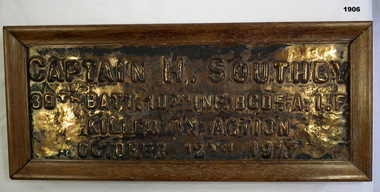 Bendigo Military Museum
Plaque - BRONZE PLAQUE WW1, Post 1918 (estimated)
Henry Southby pre WW1 served 5 years in the Militia and 22 years on the Permanent staff. He is listed as No 2240 serving in the 4th Batt Aust Commonwealth Horse during the Boer War from March to September 1902. By the time he enlisted in the AIF he was 41 years 2 months of age on 22.3.16 with the rank of Lieut in the 39th Batt. Embarked for England 27.5.16, embark for France 23.11.16, promoted Captain 23.4.17, WIA 7.6.17 shell wound to back, return to France 30.7.17, KIA 12.10.17 at Passchendaele. It is believed he was W.I.A and while being carried out by Stretcher Bearers a shell burst killing them all. No known grave. The plaque was one of many that were placed on trees in Condon St. Bendigo as a memorial to those who lost their lives. Refer 1903.2, 1905P.Bronze plaque set in a wood frame re; H.SOUTHBY. Frame is brown, the plaque lettering is raised."CAPTAIN H. SOUTHBY 39th BATT. 10th INF. BGD. A.I.F KILLED IN ACTION OCTOBER 12th 1917"civic mementoes - plaques, handcrafts - woodwork, military history, southby -
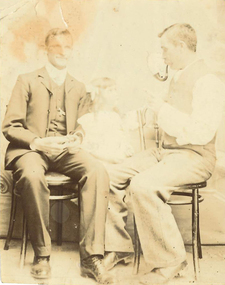 Federation University Historical Collection
Photograph, James (Jim) Smith of Happy Valley
James (Jim) Smith, (died 03/08/1974, aged 93 years) established an orchard growing snow apples near in Happy Valley after returning from mining activities in South Africa. The orchard was called "Springdallah" and was beside the Linton/Happy Valley Road across from the old Happy Valley railway station. Jim was the son of George Henry Smith (18/12/1840 - 26/11/1903) and Emma Keys Smith born Keys (07/08/1842 - 28/08/1888). George and Emma left Liverpool with other unassisted immigrants on the "Bates Family" ship with baby Clara on 08/06/1863 arriving in Melbourne on 08/06/1863. George and Emma emigrated to Australia on the invitation of Emma's brother Edward Keys who owned a property near the school at Happy Valley on which there were two houses. Teddy offered George and Emma the smaller one to live in. When "Teddy" decided to go into hotel keeping George took over the 200 acres of his property and made it a pleasant orchard and garden called "Cress Green Gardens". George had various secretarial jobs - rate collector; paymaster at the mines; until he became Shire Secretary for the Shire of Grenville, whose centre was Linton and Government Auditor for Western Victoria (1894-1903), the means of transport being horse and buggy. Another son followed his father as Shire Secretary. George and Emma had 14 children, Emma dying giving birth to Emma Keys who lived for 16 months. George later married Annie Bolte with 2 more children being born. Annie later sold the property. The land was used for grazing and the two houses fell into disrepair. In 1995 George's grandson Ernest (Alf) Alfred Watson visited the site and reported a wrought iron gate at the site and a mulberry tree near the site of his grandmother's family home. Bluestone blocks can still be seen in the paddocks from the roadside. The child in the photograph is Phyllis Joy Smith, Jim's eldest daughter. Jim Smith was the brother of Clara Emma Yung nee Smith.Sepia photo of two men and a girl. One of them is Jim Smith who established on orchard at Happy Valley. He also went to South Africa - mining activities. The orchard is now part of Clarkesdale Bird Sanctuary located at 360 Linton-Piggoreet Rd, Linton, Vic. 3360. Verso: Jim Smith South Africa (Mining) Established orchard halfway near Linton and Happy Valley. Clara Emma's brother. jim smith, james smith, clara emma smith, happy valley, yendon, piggoreet, south africa, mining, orchard, edward keys, george henry smith, emma keys smith, clara emma yung, annie bolte, shire of grenville, clarkesdale bird sanctury -
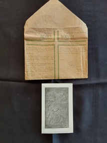 Mont De Lancey
Souvenir - Souvenir of Gethsemane - Jerusalem, Commonwealth Government, WW11 (1939 - 1945)
Olive trees have been a boon to civilization for millennia. The oil extracted from olives can be used for everything from fuel for lanterns to medicinal balms to an essential ingredient in foods. It’s easy to understand why the tree was incorporated into so many early religious practices, but near the Mount of Olives in Jerusalem, a grove of olive trees in Gethsemane provides a direct link to ancient biblical stories. At the foot of the Mount of Olives, a small olive grove would go on to become an important site for Christianity. Gethsemane, taken from the Aramaic word for olive press, is mentioned many times throughout the New Testament as a favorite place for Jesus and his disciples to rest and pray beneath the evergreen olive trees. Today, the Church of All Nations has been constructed in a section of Gethsemane, enshrining the ground where Jesus is said to have last prayed.However, as a privilege, soldiers were given one green envelope per month in which they could send uncensored personal and private letters to loved ones. The soldier had to sign to verify that they had only included private and family matters.A small vintage brown paper WWII AUSTRALIAN Active Service envelope with faded green text explaining its use, which was for letters only. It was Revised July 1942. There is a large green lined open cross on the front with Active Service at the top and (Crown Copyright Reserved). It has an address space on the right. Inside the envelope is a small folded paper souvenir from Gethsemene Jerusalem with a black and white image on the front of a relief sculpture depicting the moment when an angel visits Jesus in the garden of Gethsemane. It is titled 'Gethsemeni'. Inside the small souvenir card is a Daily Prayer for the Dying and, glued to the opposite side, an olive leaf from the Garden of Gethsemane. On the back of the souvenir is a text titled, The Good Work of the Holy Land, which describes the work of the Friars Minor who resided in Jerusalem for seven venturies. Though undated, this document dates from WWII when the soldiers were in the Middle East.'Leaf from the Trees of the Garden of Gethsemane' -
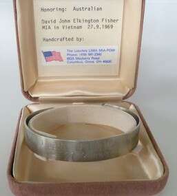 National Vietnam Veterans Museum (NVVM)
Ceremorial Object - MIA Bracelet - Trooper David John Fisher, The Laeufers LIMA MIA-POW
In 1969 Private David Fisher, a national serviceman serving with 3 Squadron SAS, became the next soldier declared missing in action. In September 1969 Fisher was second-in-command of a five-man, long range SAS patrol searching for signs of enemy activity near the Nui May Tao massif in south-eastern Long Khanh province. After patrolling for seven days in persistent rain, on 27 September the Australians had a series of sharp contacts with strong groups of Viet Cong. Outnumbered and pursued through the jungle, they called for a helicopter extraction. The helicopters arrived within half an hour, just as the enemy were closing in on the SAS soldiers. During the hectic moments of the "hot" extraction, while under fire and surrounded by the enemy, the members of the patrol clipped on their karabiners and attached themselves to ropes dangling from a helicopter and were lifted clear of the jungle. As the helicopter gathered speed and helicopter gunships moved in to fire on the enemy on the ground, the patrol members suddenly noticed that Private Fisher was missing. He had fallen from his rope from a height of about 30 metres above the tree canopy. It was later suggested that, under pressure, Fisher may have attached his karabiner to the wrong loop on the rope. An air search began within ten minutes of the incident and a ground search began within five hours. A ten-man SAS patrol searched the jungle around the site, joined the following day by rifle companies who searched for the next six days. Fisher's body was never found, and he was declared missing in action, presumed dead. He had only two months remaining of his tour of duty.Stainless steel open-ended bracelet engraved with missing serviceman's full name and date missing. In a buff square velvet satin-lined box.David John Elkington Fisher 27/09/69mia, david john elkington fisher, trooper david john fisher, 2787344, australian national serviceman, royal australian infantry corps, 2nd special air service squadon, 3rd special air service squadron, sas -
 Box Hill Historical Society
Photograph - P Bird's timber merchant
P Bird's timber merchant brick premises established 1918 and original building with staff lined on the street.Sepia photo mounted on cardboardHandwritten family history of original donor "Ruby Sweetland daughter of Frederick & Emma Sweetland Hay N.S.W./ granddaughter James & Mary Ann Adelaide Collier, Box Hill./ now wife of Alexander Thomas Gunn of Hepburn Springs Vic 1976/Mary Ann Adelaide Collier nee Britnell, was born on way out/to Australia in the St. Vincent Gulf in a sailing boat near Adelaide/ Sth Australia, hence the name of Adelaide/ Alexander Thomas Gunn's grandfather owned the No 1 Country Hotel Licence at Kangaroo Flat "The Glasgow Arms/Hotel. near Bendigo Victoria, about 1840./ They had a family of 6 boys & 5 girls/4 boys Tom, Dan, Jack & Alexander took up land in Thorpedale/ Victoria about 1860 & paid 1 [pound] an acre for it. This land was covered/ in dense forest fern tree & fern gullies & would rain for 6 months/ in this district was the tallest tree in the world height 365 feet./ Palling splitting was main source of living for many years after being/ cleared now produces the best potatoes in Victoria. Very pretty hilly country"bird's timber yard, businesses, bird> p., timber yards, timber merchants, employees -
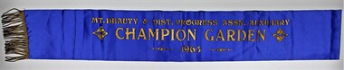 Kiewa Valley Historical Society
Sash, Mount Beauty Garden Sash
1947 The SEC created an Arboretum and Nursery on the bank of the West Kiewa River. Householder could collect free plants, trees and topsoil for their gardens. It was not long before there was very keen competition amongst the families to create the best garden. 1948 A Mount Beauty Garden competition started with a first prize of 15 pounds, second 7 pounds and third 3 pounds. As the oldest garden in the competition was only 25 months old and most were younger a handicap system of 4 points per month was devised. Tom Mitchell MLA was the donor and judge. 1965 This sash was possibility worn by Jean McCullough in 1965 when the Mt Beauty & District Progress Association Auxiliary ran the completion.An example of the social life at Mt Beauty during the construction of the Kiewa Hydro Electric Scheme.Royal blue sateen sash with gold fringe. Mt. BEAUTY & DIST. PROGRESS ASSN. AUXILIARY/CHAMPION GARDEN/1965textiles, arboretum, mount beauty, garden competition, kiewa hydro electric scheme -
 Bendigo Historical Society Inc.
Document - TOWN HALL, THE BENDIGO CHORAL SOCIETY, 13 Sep., 1922
Town Hall, The Bendigo Choral Society. Season 1922, 2nd Concert. Oval photo of Mr. W C Frazier A.R.C.O. Conductor. Twenty = first Grand Concert. Town Hall, Bendigo. Wednesday, Sept. 13th, 1922. Artists: Madame Elsie Davies. Miss May McGauchie, Miss Myrtle Knight, Mr. L Bienvenu. Conductor: Mr. W C Frazier, A.R.C.O. Pianiste: Miss Eileen Hains, A.T.C.L. Patron-His worship the Mayor (Cr. M G Giudice). President- Mr. H M Leggo. Vice Presidents: Sir John Quick, Hon. Sternberg, M.L.C., Hon. Herbert Keck, M.L.C., Hon. R H S Abbott, M.L.C., Hon. D Smith, M.L.A., Mr. A. A. Dunston, M.L.A., Cr. J H Curnow, Cr. J E Holland, Mr. Oscar Flight, Mr. E S Cahill, Dr. W J Long, Dr. O Penfold, Mr. A L Bolton, O.B.E., Mr. G E Bolton, Mr. D Berriman, Mr. Alf E Wallis, Mr. J G Oliphant, Mr. Arthur Whitehead, Mr. W Watts, Mr. A E Sayer, Mr. William Wright, Mr. Magnus Cohn, Mr. Geo. Mackay, Mr. Barkly Hyett, Mr. A G Finister, Mr. W E Bradshaw, Mr. W J Campbell, From the performing members: Mr. E H Collett, Mr. A W McGibbony. Conductor: Mr. W C Frazier, A.R.C.O. Sub-Conductor: Mr. E A Miller. Pianiste: Miss Eileen Hains, A.T.C.L. Treasurer: Mr. D H Holden. Librarians: Mr. R J Duguid, Mr. H Veale, Mr. W Mansell, and Mr. A Ditchburn. Auditor: Mr. H T Bayton, A.A.I.S., L.I.C.A. Committee: Office Bearers, with Mesdames T Scott and Darvall, and Misses Colgan, Gail, Jamieson, Lethlean, and Messrs. Jeffery, McClure, H Cock, F J Walter and Wittscheibe. Including Tax: 2/6 Reserved, 1/6 Ordinary. Hon. Secs.: J Hudspeth, 85 Wills Street, Z S Martin, 66 McKenzie Street. Concert to commence at 8 pm. Programme Songs: The Dark-eyed Sailor, Just as the tide was flowing, Nelson's Gone a Sailing, The Radiant Morn of Spring, Una voce poco fa, Hullamzo Balaton, Morning Hymn, Awake, Sweet Love, Now is the Month of Maying, Brunhilde's Battle Cry, Cradle Song, The Three Fishers, Legende, To the Forest, I heard you go by, The Lilac Tree, Se, Sailing at Dawn, Song of the Sou'' Wester, The Little Admiral, Farwell. Words for some songs in program. Artists: Mr. L Bienvenu, Ladies of the Choir, Madame Elsie Davies, Miss Myrtle Knight, Miss May McGauchie, Ladies of the Society, Choral Society. God Save The King. BIZET'S Garmen. Special Announcement. This popular and celebrated Opera will be given I its entirety at as early a date as possible. Vocal scores have specially cabled for from London. Mr. Frazier would welcome the co-operation of the vocalists of our city in the performance of this charming Opera. Rehearsals commence next Tuesday at the Temperance Hall at 8pm, when it is hoped there will be a large response to his request. The public are reminded that the subscription to the Society is only 1/1/- per annum. Secretaries will be glad to give all information. Joint Hon. Secs.: J Hudspeth, 85 Will St., Z S Martin, 66 McKenzie St.Boltons Print, Bendigoprogram, theatre, town hall, the bendigo choral society. season 1922