Showing 186 items matching "trees in victoria park"
-
 Glen Eira Historical Society
Document - National Council of Jewish Women
This file contains two items relating to the National Council of Jewish Women (Victorian Section): 1/An invitation to the 63rd Annual Luncheon of the National Council on 14/03/1990, at Tudor Court Receptions, 141 Kooyong Road, Caulfield. The invitation states that the guest speaker will be Annette Allison, media and television personality. Inside the invitation when unfolded, is a long list of the Council’s Patronesses and Hostesses 2/A photocopy of a newspaper article entitled ‘NCJW moves into new home’ by Eileen Vamos, date and newspaper unknown, relating to the opening of the National Council’s new Victorian Headquarters at 131-133 Hawthorn Road, Caulfield North, named the Annia Castan Centre and Sadie Fink offices. The article discusses the opening Caulfield Park, the work of Annia Castan and Sadie Fink after whom the headquarters were named, and plans for the use of the Annia Castan planting a tree as others look on, and the other of Mayor and Mayoress of Caulfield, Jack and Felicitie Campbell, at the planting ceremony.national council of jewish women, tudor court receptions, kooyong road, caulfield, solomon geulah dr., allison annette, caulfield park, hawthorn road, caulfield north, bassat nina, castan annia, fink sadie, fink mina, fink jack, shipton roger, mccutcheon andrew, cornard geoff, campbell jack mayor, capbell felicitie mayoress, shulman phillip, curan george, sokolowich aaron, balint susie, mallinek malvina, samuel ian, sheedy ray, ilan, open door project, jewish welfare society, jnf victoria, westbury street, balaclava, jewish community, open ceremony, community groups, tree planting ceremonies, official events, mayors, annie castan centre, sadie fink offices -
 Flagstaff Hill Maritime Museum and Village
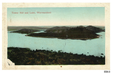
Postcard - Scenic, Warrnambool, Tower Hill and Lake, Warrnambool, 1902-1929
The nine postcards in this set were donated together and date to the early 1900s. All but one postcard in this set shows images of Warrnambool, in the Western District of Victoria; the other has a London image. The postcards were all printed in Great Britain according to that country’s postal regulations. The fronts of all cards have titles printed in red. Most of the images on the cards are attributed to photographer Joseph Jordan and belong to the Jordan Series. The back of these cards has an outline for a postage stamp, a vertical dividing line and a heading on each side of the line to separate the Correspondence from the Address. Postcards or ‘correspondence cards’ appeared in Britain in 1894. They were plain cards with a space for the message on one side and an address on the other; regulations didn’t allow anything but the address to be written on the ‘address’ side. In 1902 the British regulations then allowed a picture to be printed on the front and the address on the back, so messages had to be written on the picture side. Soon, the regulations changed and the back was divided for a message and the address. Tower Hill and Lake, Warrnambool – Tower Hill Wildlife Reserve is in the crater of a dormant volcano. In 1892 the area was declared a National Park, the first in Victoria, preserving native animals and Indigenous plants. The rich volcanic soil in the area attracted early settlers including the families of Henry Giles, born at Tower Hill in 1858 and his wife Mary Jane (born Freckleton) born nearby at Cooramook in 1860. Henry and Mary worked in the local area where they also raised their six children. For a time, Henry was employed as a labourer on the Warrnambool Breakwater. Joseph Jordan - Joseph Jordan was born in 1841 in Leicester England. When he was 16 he joined the 7th Queen's Own Hussars and was sent to India at the outbreak of the mutiny. He took part in the relief of Lucknow and remained in India for eleven years. It was during this time that he became interested in photography. He was posted to New Zealand and later came to Victoria, becoming a sergeant major of the Mounted Rifles. In the mid-1880s he came to the Western district where he was responsible for establishing units of the Mounted Rifles in various country towns such as Dunkeld, Mortlake, Panmure, Bushfield, Koroit etc. He resigned from the army in 1889 and set up a professional photography studio in Liebig Street, Warrnambool. He became very well known in the Western District for family photographs, official photographs of local councillors and groups as well as views of local scenery. In 1891 he photographed the wrecked barque ‘Fiji’ at ‘Wrecks Beach’ near Princetown. His business was taken over by his son Arthur around 1917. Joseph was a keen rifle shot and in 1924 he donated the "Jordan Shield" as a prize to the Victorian Rifle Association. He was made a "Life Honorary Member" of the Warrnambool Returned Soldiers League and in 1933 he was recognised as being the oldest living soldier in Victoria. Joseph died in 1935 aged 95.The postcard of Tower Hill and Lake is connected to the location near Warrnambool where many of our early settlers lived and worked. One of these settlers was the Giles family, whose son Henry was born at Tower Hill. His family has donated many Victorian-era items which are now on display at Flagstaff Hill. Tower Hill National Park is the first place in Victoria to be named a National Park. As in the times when coastal trading ships brought passengers and cargo to the Port of Warrnambool, it continues to be a popular place to visit. Joseph Jordan is a significant figure in Warrnambool history as he helped to establish early units of the Mounted Rifles (G Company) in local towns during the late 1880's and later, photographed local scenes, groups and citizens of early Warrnambool.Postcard, one of nine, landscape orientation, coloured print within a rectangle and an impressed line around the image on the front. The picture shows several islands close together with hills around them and bushland in the foreground. There are dead trees amongst the vegetation and a sandy shore at the foot of some of the hills. The lower left corner shows what appears to be two white rails, possibly a lookout fence. There is no correspondence written on the card. The title is printed in red on the front and the back has inscriptions and outlines for a postage stamp. Jordan Series, printed in Great Britain. Front, in red: “Tower Hill Lake, Warrnambool” Back in green: “Jordan Series” “POST CARD” “PRINTED IN GREAT BRITAIN” “For correspondence” “The Address only to be written here”flagstaff hill maritime museum, flagstaff hill maritime village, flagstaff hill maritime museum and village, maritime museum, warrnambool, great ocean road, warrnambool and district, warrnambool scenes, local scenes, views of warrnambool, joseph jordan, jordan series, jordan photography, postcard, souvenir, correspondence, cameo postcard, tower hill, tower hill national park, victoria's first national park, henry giles, mary jane freckleton, breakwater, early settlers -
 Federation University Historical Collection
Book, C. French, A Handbook of the Destructive Insects of Victoria, Part One, 1891 (exact)
Purple hardcovered book153 pages plus 20 figures. Contents inlcude: Introduction to Entimology, classification of insects, quarantine rules, Woolly Aphis, Codlin Moth, Curve-winged Apple moth, Apple-tree borer, Apple-bark Scale, Apple Beetle, Red Spider, Harlequin Fruit Bug, Pear and Cherry Slug, Rutherglen Fly-pest, Cherry borer, Pear Phytoptus. Coloured plates (by C. Brittlebank)of insects and figures (by Hart Vonarx) include the Knowles' Pump, Charnwood Spray, Danks' Lever Spray Pump, Spawn's Climax Spray, Apparatus for Sparying Orange Trees, Strawsonizer, French Portable Hand Spraying Machine, Lowe and Park's Insect Exterminator, Greenhill Codlin Moth Lamp, Wolfskill Fumigator, Tutus Fumigator, Oliver Fumigator, Agitator Spray PumpBookplate - Ballarat School of Mines Ballaarat No 1201. Presented by Secretary for Agriculture, Melbourne, 14th July 1891 insects, pumps, c brittlebank, hart vonarx, c french -
 Federation University Historical Collection
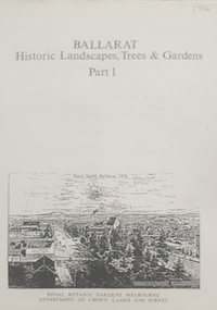
Book, Peter Lumley et al, Ballarat: Historic Landscapes, Trees & Gardens, 1983, 1983
Lisa Green and Lisa Morcom of Ballarat College of Advanced Educatiion contributed to this report.275 page landscape study of Ballarat including Trees in the Victorian Landscape; Plant sources early Ballarat nurseries, Botanical Gardens, Lake Wendouree, Fairy Gardens, Victoria Park, Ballaarat Old Cemetery, Eastern Oval, City Oval, Ballarat East Town Hall Gardens, Eureka Stockade, Observatory, Yarrowee, Black Hill, Sovereign Hill, Cheek Channels, Canadian Creek, Poverty Point Reserve, Goldmining Relics, Woah Hawp, Buninyong, street plantings, Russell, Victoria, Bridge Mall, Sturt Street Gardens, Avenue of Honour, Webster, Elms, ballarat, trees, nursery, r.u. nicholls, francis moss, ballarat botanical gardens, victoria park, lake wendouree, ballaarat old cemetery, eastern oval, ballarat east town hall gardens, ballarat school of mines botanical gardens, eureka stckade recreation reserve, ballarat observatory, yarrowee creek, black hill reserve, sovereign hill, ballarat avenue of honour, victoria street plantings, bridge mall plantings, george longley -
 Federation University Historical Collection
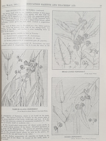
Book, Victoria Education Gazette and Teachers' Aid, 1921-1930, 1921-1930
The Victoria Education Gazette and Teachers' Aid was published for Victoria's teachers and was sent to all school on the state. In 1920 The Ballarat School of Mines had donated 136 pounds 14 shillings and 10 pence to the Victorian Education Department's War Relief Account, and the Ballarat Junior Technical School had donated 10 pounds 6 shillings and 10 pence.Ten black hard covered volumes with red tape spine, covering 1921 to 1930. The gazettes include Education Department appointments, transfers, resignations and retirements, vacancies, notices, queries, notices of books, examination papers, original articles, lesson plans, suggestions for lessons, drawing, obituaries, notes on nature study, mathematics, music, sloyd woodwork, English grammar, Victorian State School Swimming Clubs, Geography, penmanship, science, History, Latin, Geography, The School Garden, horticulture, singing, World War One; ANZAC Day, lifesaving, Astronomy, Empire Day, ANZAC Buffet London, Victorian Education Department's War Relief Fund .1) 1928. Articles include: New Caledonia, Swimming and Lifesaving, School forestry, a visit to the pyramids, Exploration of Gippsland, paul de Strezelecki, Angus McMillan, Villers Bretonneux Memorial School, American Black Walnut, Red Gum, Messmate Stringybark, The Great Barrier Reef, retirement of Frank Tate, Stawell High School, Report on Some Aspects of Education in the United States, Jubilee Education Exhibition , New School Readers; measured Drawing Images include: Macarthur Street School's Plantation, Maryborough School Plantation, Pinus Insignis (Radiata) ready for Milling, Creswick State Forest, Metalwork, Daylesford Pine Plantation four years old, Henry Harvey (art Inspector); Omeo School Endowment Plantation; Frank Tate; Stawell High School Drawings From Casts; Lake Tyers School Endowment Plantation, measured drawing, Thomas H. Stuart, GEorge Swinburne. J.R. Tantham-Fryer, Cookery Class, John Edward Thomas. .3) War Savings Stampsm Swimming and Life-saving, Teh Rural School System of Victoria, Imaginative Composition, ANZAC Day, Retardation, Teh Bright Child Hudson Hard Obituary, Leeches, Relief for Distress in Europe, Dental, Teachers' Library, History of Portarlington, J.E. Stevens Obituary, Victorian Teachers in England Images: Swimming and Life-Saving Medallion .3) Swimming and Lifesaving, Bronze medallion, Victoria Leage of Victori, War Savings Stamps, Rural School Sytem of Victoria, .4) War Relief, Talbot Colony for Epileptics Masonmeadows, Discipline New and Old (Percy Samson), Soldier teachers, Preservation of Australian Birds, Arbor Day, Jubilee of Free Education, Teaching Geography, Poery in Schools, School Committees, Shelter Pavilion, Mysia Memorial School, Clovers, Jubilee Exhibition, Domestic Arts, Louis Pasteur, .5) Victoria League of Victoria, An Endowment Scheme (Pine Plantations), School Endowment Plantations, Protecting our trees by Owen Jones,. Victorian State Schools Horticultural Society, Sloyd Woodwork, School Forestry, Thomas Brodribb Obituary and portrait, Imperial Education Conference London, school Management and Method, School plantations, Eucalypt plantations in the Bendix and Heathcote District, Junior Red Cross, Jubilee Education Exhibition, Gould League Competitions, handwriting, The School Magazine, Frank Tate in London, Victorian beetles, Council of Public Education, Villers Bretonneux and its new School, Death of Samuel Summons, Woodwork Summer School, Swimming, Japanese Relief Fund, Retirement of John Cross, reminiscences of the Late Mr Albert Mattingley .6) Thomas H. Trengrove and the Villers Bretonneux School hall and pilaster carvings, forestry, visit of Maryborough teachers to Ballarat Water Reserves, noxious weeds, relief for Distressed Europe, The Dalton Plan, Empire Day, Retirement of Mr Fussell, Centenary of Hume and Hovell Expedition, League of Kindness, Effective Nature Study in a Rural School, Some Facts About Paper and their Bearing Upon School Plantations, Council of the Working Men's College Melbourne, Maria Montessori, University Vacation School, Horticulture in State Schools, An Informal Chat About French Schools (C.R. McRae), The Vacation School, Johann Heinrich Pestalozzi, Inspector's Report on a 5th-class School, Can Children Write Verse, John Adams, Victoria League of Victoria, R.F. Toutcher, Sir James Barbie's Address to High-School Girls, Impressions of a High School Teacher Abroad (R.D. Collman), The Spirit of the School Plantation Scheme, Monument of the Late Mr and Mrs A.T. Sharp at Box Hill Cemetery, The Teaching of Geography, The Treatment of Poetry in Class, Two Difficult Arithmetic Lessons, Location of Principal Australian Timbers, Dr John Smyth, Stammering and its Influence on Education, Wireless Broadcasting as an Educational Medium, Boys School at Villers Brettonneux, The New School at Villers Brettonneux, Bird Day, Messmate or Stringybark, What Every Woman Knows, Director's Report on Denmark .7)1925 . Includes: School Forestry, horticulture, J.H. Betheras retirement, Ivanhoe School, Coburg School, Moorabool Junior Technical School, Villers Bretonneux School hall and pilaster carvings, Francis Ormond, William Charles Kernot, Corsican Pnes at Creswick, Ballarat High School Plantation, Workin Men's College, RMIT, Naorrow LEafed Peppermint, Education and World Peace, Eucalypts of Victoria, John C. Eccles, Blue Gum. Manners, Giving the Poorly Nourished Boy A Chance, Native Ferns, Marybourough Technical School, Memorial School at Villers-Brettonneux .8) Experimental Plots in Country Schools (W.W. Gay), Villers Bretonneaux and its Memorial School. nominated classes for Art Teachers, The Teachers Act 1925, Horsham High School, Richmond Technical School, Farewell to Messrs C.R. Long and Ponsonby Carew-Smyth, Frank Tate, Phyiscal Training, Arbor Day, ANZAC Day, Shakespeare Day,Bendigo Junior Techncial School, Musical Appreciation, Motor Dental Unit, School Camps, Education Act of 1872: Mr Angus McKay's Part (George Mackay), A Bush Fire Experience (Irene Stable), Black Sunday, Californian Red Pine, Women's Education in America, Farewell to Lord and Lady Stradbroke, Grevilia Robusta, Silky Oak, Redwood, John E. Grant, The Need for Research (Donald Clark), Junior Drama, Ida D. Marshall, John Pounds, Australian Books, Fish Creek School, State Boundaries, History in the Curriculum, Ceramic Art in Australia (Percy E. Everett), Choice of School Songs, Tasmanian Beech, Should History be Taught on a National or an International Basis, Hydatid Disease, James Holland Obituary, Florrie Hodges, Queensland Maple, Post Bushfire Ruins at Fumina, Arbor Day at Fumina, Queensland Rosewood, Omeo Endowment Plantation, Bird Day, Junior Red Cross, Pioneers' Day, Edward Henty, Junior Technical Schools, Yellow Pine, History and Progress of Needlework, A.B.C. of Astronomy, Northumberland Mental tests, Queensland Red Cedar, Teh Globe Theatre, .9) 1927 includes The ABC of Astronomy, Atr Theatre, English Beech, Angus McMillan Art Pottery, School Singing, State Schools' Nursery, School endowment plantations, Making a Man, experimental proof of Charles's Law, John Smyth obituary and portrait, Linton Pine Planation, motivation of arithmetic, Women's Classes at Dookie, Swimming and Lifesaving, Pioneers Day, Drawing, Ballarat High School planation, biting fly, Tir-Na-N'og, John Byatt retirement and portrait, Technical Schools Conference at Daylesford, Ethel Osborne and portrait, library. Francis Thompson portrait, Adam Lindsay Gordon, Solar movement, motor transport, Liverpool Cathedral, Teh Story of the Cathedral, Bendigo School of Mines, Omeo School pine plantation, Egypt and the Nile, Self-Criticism Images include Ballarat High School Pine Plantation, Vale Park, Francis Ormond, Woking Men's College (RMIT), W.N. Kernot, A Stand of Corsican Pines at Creswick, Victoria .10) Some Remarks on the Relationship of the technical Schools to the University (Donald Clark) , Present Day Education in England , Memorial to Joseph Cornwall, Spelling, motivation, Singing, State Scholarships, Agriculture, T.W. Bothroyd, The Swimmer - A Summer School Sketch (H.H. Croll), Swimming woodwork, Farewell to Dr Sutton. ,Drowning, War Savings Movement, White Beech. George S. Browne , Example of School Honor Book, Blackwood, Optimistic teacher, Soldier settlement around Shapparton, Oral Hygiene, Cinema Machines, Basketball, Wakter M. Camble obituary, ANZAC day Pilgrimage in England, Froebel's System, Montessori Method, War Relief Fund, New Zealand Kauri Tree, Bat Tenis at a Bush School., Advice to Australian Girls, Chrysanthemums, Royal Visit, National Parks of Victoria, Maurice Copland Obituary, total eclipse of the Moon, School libraries, The teacher and the COmmunity (A.M. Barry), The Reading Lesson, Swimming and Life-saving, MElbourne Teachers' College War Memorial Windows Old Trainees War Memorial, Cultivating a Natinoal Art education gazette, school, education, teaching, teacher, world war one, school plantations, macarthur street pine plantation, school forestry, creswick state forest, anzac day, armistance celebrations, frank tate, frank tate retirement, drawing from cast, education department school readers, lake tyers pine plantation, w.n. kernot, rmit, working men's college, francis ormond, pine plantations, calenbeem park, creswick, villers-brettonneux school hall and carvings, thomas trengrove, corsican pines, creswick, pine endowment plantations, mccarthur st primary school pine plantation, ballarat high school pine plantation, vale park, mount pleasant primary school pine plantation, golden point pine plantation, angus macmillan, paul de strzelecki, gippsland, villers-bretonneaux memorial school, francis thompson, english ash, pestalozzi centenary, shakespeare day, swimming classes, clear pine, cinema in education, american black walnut, red gum, thomas wolliam bothroyd obituary, and portrait, physical training displays, teaching of spelling, ohm's law, blue gum -
Federation University Historical Collection
Book, Historic Sites Survey: North Central Study Area, 1979, 1979
The North Central Study Area included the Shires of Avoca, Bet Bet, east Loddon, Goulburn, Untly, Kara Kara, Korong, Maldon, Marong, Metcalfe, McIvor, Newstead, Strathfieldsaye, Stawell, Talbot, Clunes, Tullaroop and Waranga. 153 page book with white plastic binding. It is an historic sites survey for the North Central Study Area commissioned by the Land Conservation Council, the Ministry for COnservation and the Australian Heritage Commission. castlemaine, mount alexander goldfield, maldon, percydale, warrenmang, moliagul, tarnagulla, stuart mill, the whipstick, whroo, rushworth, graytown ironbark forest, st arnoaud, new bendigo, landsborough, inglewood, kurting, wedderburn, wehla, kooroora, langham flat, mcintyre, rheola, diamond hill, fosterville, coliban water works, green gully, newstead, muckleford forest, costerfield, graytown, bailieston, waranga irrigaiton system, eucalyptus distillery, mia mia bridge, korokubeal township researce, concegella slate quarry, chewton, fryerstown, kingower, timor, talbot, majorca, carisbroook, clunes, st arnaud, taradale, icomos, dunolly, limestone, castlemaine slate quarry, harcourt granite, taradale railway viaduct, loddon united waterworks trust, gouldburn weir, carisbrook lock-up, history of tree planting in streets, history of public reserves, r.u. nicholls nurseryman, thomas lang, francis moss, ballarat botanical gardens, ballarat school of mines botanical gardens, lake wendouree, victoria park, ballarat, muont holled smith, ballaarat old cemetery planting, eastern oval, ballarat east botanical gardens, ballarat east town hall gardens, eureka stockade reserve, ballarat observatory plantings, yarrowee creek plantings, yarrowee bluestone channels, ballarat woollen mill, band and albion mullock heap, black hill plantings, yarrowee creek channels, canadian creek channel, specimen vale channel, poverty point reserve, union jack reserve buninyong, imperial mine, buninyong, victoria street plantings, bridge mall, sturt street gardens, ballarat avenue of honour plantings, white flat oval plantings, camp street, elms, burnt creek -
 Federation University Historical Collection
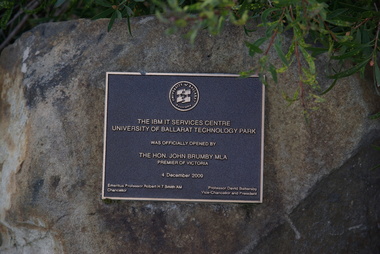
Photograph - Photograph - Colour, Clare Gervasoni, Ballarat Technology Park Buildings, 2015, 13/0/2015
IBM were an early tenants at the Federation University Technology Park at Mt Helen.ballarat technology park, ibm, john brumby, state revenue office, jeff kennett, berry street, canadian wetlands, specialist diagnostice services primary health care limited, canadian creek, scarred tree, cherry ballart, ibm its services centre, gec -
Federation University Historical Collection
Booklet, Buninyong Heritage Walks and other Interesting Cycle Rides and Scenic Drives, 2008
Blue soft covered book, with maps, plans and photographs relating to Buninyong, Victoria. buninyong, de soza park, buninyong tannery, buninyong railway station, eagle hotel, old buninyong library, hastie's hill, buninyong town hall, hastie's spring, crown hotel, buninyong post office, bowen tree, aborigines, buninyong primary school, buninyong cemetery, gold monument, mount buninyong, lal lal falls -
 Ringwood and District Historical Society
Newspaper, Scrapbook Clipping, Library Collection, Ringwood, Victoria, `
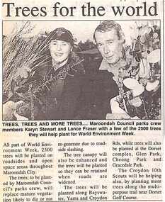
``Newspaper clipping from "The Post", 14-6-95, P 11. Trees for the world Maroondah Council parks crew members Karyn Stewart and Lance Fraser with a few of the 2500 trees they will help plant for World Environment Week. The trees will be planted on roadsides and open space areas throughout Maroondah City.` -
 Bendigo Historical Society Inc.
Postcard - ROSALIND PARK
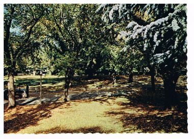
Postcard: Image shows view of trees in Rosalind Park. On LH side of pathwasy, man with tractor. On back ' Bendigo, Victoria, pleasant autumn setting in Rosalind Park'Nu Color Vue, BE 33, Copyrightbendigo, parks and gardens, rosalind park, bendigo, rosalind park -
 Bendigo Historical Society Inc.
Postcard - SOUND SHELL, ROSALIND PARK
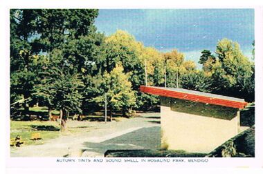
Postcard: Sound Shell in Rosalind Park, Bendigo. Image shows building with skillion roof, trees in LH and background. On bottom ' autumn tints and sound shell in Rosalind Park, Bendigo.' On back ' situated 92 miles north of Melbourne, Bendigo is the gateway to Northern Victoria. It is an attractive City with many modern facilities (unclear) Gardens and Cultural centres.'Nucolorvue Productions, No. 3, copyrightbendigo, buildings, sound shell, rosalind park, bendigo, sound shell, rosalind park -
 Bendigo Historical Society Inc.
Postcard - LOOKOUT TOWER ROSALIND PARK BENDIGO
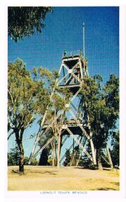
Postcard: poppet head lookout tower, Rosalind Park, Bendigo. Image shows poppet head, eucalypt trees surrounding it. On bottom ' Lookout Tower, Bendigo' On back 'situated 92 miles north of Melbourne, Bendigo is the gateway to Northern Victoria. It is an attractive City with many modern facilities, fine Gardens and Cultural centres.Nucolorvue Productions, No. 12, Copyright.bendigo, buildings, lookout tower, rosalind park, bendigo, lookout tower, poppethead, rosalind park -
Bendigo Historical Society Inc.
Document - JUNE PARRY COLLECTION: MINING IN BENDIGO - LETTER TO MISS J. PARRY
Typed letter from W. M. Flentje to Miss J. Parry, Secretary, Bendigo Historical Society referring to the preservation of land to preserve mining relics. Part of the land may extend into private property and some crown Land. He says 'If the Land Conservation Council should decide to add the Crown land part of the area to the Forest Park, then preservation of the area will become our responsibility.' Letter written Forests Cmmission Victoria letterhead. It has a green logo on toe top of two trees, one eucalypt type and the other, a pine. Letter dated 10th December, 1976.document, memo, mining in bendigo, mining in bendigo, letter to miss j parry, forests commission victoria, whipstick forest park advisory committee, w m flentje -
 Bendigo Historical Society Inc.
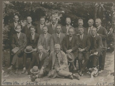
Photograph - GROUP OF SEVENTEEN MALES DRESSED IN SUITS, IN PARK, 8 Feb, 1928
Sepia photograph mounted on brown board. Seventeen adult males dressed in suits, ties and hats, arranged in three rows in front of trees. Male at R C row wearing clerical collar. Inscriptions: in image - handwritten at bottom 'Committee of School Picnic Excursion to Castlemaine Feb 8th 1928' At BR corner of mount 'of Arms, Under Royal and Vice Regal Patronage, Lorraine Pty Ltd, Castlemaine', at TR corner 'GP 72', On back TR 'GP 72', 'Royal Historical Society of Victoria, Bendigo Branch, circular stamp. Red ballpoint '12'.Bendigo Advertiserperson, group -
 Bendigo Historical Society Inc.
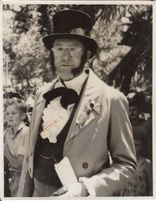
Photograph - BENDIGO CENTENARY COLLECTION: ADULT MALE IN COSTUME, IN PARK, c.1951
Black and white photograph. One adult male in costume. Cut-away coat, waistcoat, frilled shirt, top hat. Wearing ribbon on lapel marked 'President'. Watch chain. Children in background under trees. Inscriptions in image: On back 'MP189'. Circular purple stamp 'Royal Historical Society of Victoria, Bendigo Branch', '1960', '97', '294'. On back 'Copyright, Bendigo Advertiser'. 'Bendigo Advertiser Photographic Services, for re-order quote CD294'.Bendigo Advertiserperson, individual, centenary, see also 2000.511.01, 2000.512.01, 2000.513.01, 2000.514.01, 2000, 515.01, 2000.516.01, 2000.517.01, 2000.518.01, 2000.519.01, 2000.521.01, 2000.522..01, 2000..523.01, 2000.524.01 -
 Bendigo Historical Society Inc.
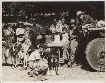
Photograph - BENDIGO CENTENARY COLLECTION: YOUNG MALES IN COSTUME IN PARK, 1951?
Black and white photograph. Four young males in costume, two goats - one being milked, one male sitting on jinker with wood wheels. Crowd of people watching in background. Trees at back in park. Inscriptions: on back 'MP' 186', circular purple stamp 'Royal Historical Society of Victoria, Bendigo Branch'. '1960', '97', 269A'. History of object: Previous Acc. No. 'MP 186'. James Lerk 'Centenary of Bendigo?' On back - 'Copyright Bendigo Advertiser', 'Bendigo Advertiser Photographic Service' . 'For re-order quote CD 269A'Bendigo Advertiserperson, group, centenary ?, see also 2000/511/01, 2000.512.01, 2000.513.01, 2000.514.01, 2000.515.01, 2000.516.01, 2000.517.01, 2000.518.01, 2000.519.01, 2000.520.01, 2000.521.01, 2000.522.01, 2000.523.01, 2000.524.01 -
 Bendigo Historical Society Inc.
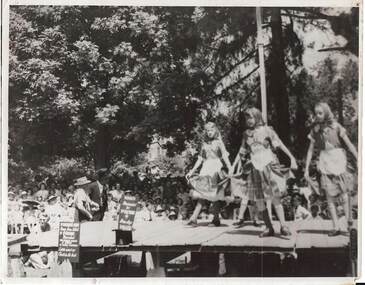
Photograph - FOUR YOUNG FEMALES IN COSTUME DANCING ON STAGE, IN PARK, 1951 ?
Black and white photograph, four young females in costume dancing on stage, in a park. Large crowd under trees watching. Inscription: In image on board on stage 'Nuggets, presented by Dr Backhaus by Bendigo Diggers'. History of object - previous Acc. No. '185'. James Lerk 'Centenary of Gold?'. In image 'Dr Bacchaus's chair, stump from which? Dr Backhaus preached. First ordained preacher or minister on Bendigo Goldfields. On back 'MP 185'. Purple circular stamp 'Royal Historical Society of Victoria, Bendigo Branch', '1960', '97', 'CD 279'. 'Copyright, Bendigo Advertiser, 'Bendigo Advertiser Photographic Service. For re-order quote CD 279'Bendigo Advertiserperson, group, centenary, see also 2000.511.01, 2000.512.01, 2000.513.01, 2000.514.01, 2000.515.01, 2000.517.01, 2000.518.01, 2000.518.01, 2000.519.01, 2000.520.01, 2000.521.01, 2000.522.01, 2000.524.01. -
 Bendigo Historical Society Inc.
Photograph - POST OFFICE: SANDHURST, approx. 1905 - 1910 ?
sepia photo: view of Post Office, Sandhurst from Rosalind Park, fence and trees in foreground. Fence formed from strips of wood forming diamond shaped lattice.previous reg. no. (reverse) Rohal Historical Society of Victoria, Bendigo Branch, 1959 50cottage, miners -
Bendigo Historical Society Inc.
Postcard - ROSALIND PARK,BENDIGO, VICTORIA
Sepia photograph Rosalind Park Bendigo, Postcard format. Photograph includes unsealed path, pavers, hedge, quite large trees, monument that has a life size man's head and shoulders, writing below. Postcard published by 'The Rose Stereographs' Armadale, VictoriaThe 'Rose' series De Luxe P.3180photo, garden, rosalind park, postcard, rosalind park bendigo, photograph, the rose series p.3180, monument -
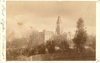
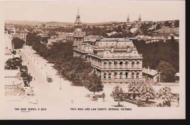 Bendigo Historical Society Inc.
Postcard - PALL MALL AND LAW COURTS, BENDIGO, VICTORIA
Postcard :image shows Law Courts on RH side, looking south towards City Family Hotel, tram in centre of Pall Mall, no cars. Palm trees in foreground in park, horse and trap in foreground. Spires of churches in View Street in skyline. On bottom: The Rose Series P 3213, Pall Mall and Law Courts, Bendigo Victoria.bendigo, streetscape, pall mall, bendigo, pall mall, law courts -
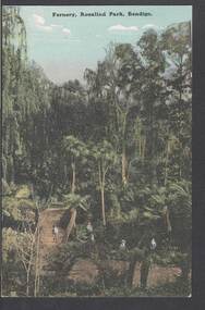 Bendigo Historical Society Inc.
Postcard - FERNERY, ROSALIND PARK, BENDIGO
colour postcard: Fernery, Rosalind park, Bendigo. Image shows Fernery in Rosalind Park, Bendigo. Lush foliage, including tree ferns, taller eucalypt trees in background. 4 children in foreground, one standing on bridge over waterway. On rear written in black pen: ' this is a good one of the Park, don't you think - I suppose you remember when we went there - With love, May.' Addressed to Miss E M Dahlsen, Nicholson Street, Bairnsdale. Stamp has Victoria, One penny, printed.bendigo, parks and gardens, fernery, rosalind park, bendigo, fernery, rosalind park -
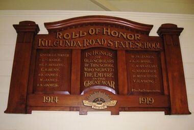 Coal Creek Community Park & Museum
Honour Roll, Kilcunda Road School Honor Roll
This WWI Honor Roll was originally displayed in the Kilcunda Road State School (no.3337), which was located at the north east corner of the intersection of the Bena - Kongwak and Buchanans' Roads, Bena, Victoria, 3946. The school was located amongst the cypress trees at 645 Bena-Kongwak Road. The school was relocated in 2008 to the Coal Creek Community Park and Museum, 12 Silkstone Road, Korumburra, 3950 to become the Masonic Lodge building in the park display. On the west side of the intersection of the Bena - Kongwak and Buchanans' Roads is a brass plaque on a granite boulder with the following inscription TO COMMEMORATE THE DISTRICT OF KILCUNDA ROAD First Surveyed 1879. This is the site of the KILCUNDA ROAD UNITING CHURCH 1911 to 1966. Diagonally opposite at 645 Bena-Kongwak Road was the site of the KILCUNDA ROAD PRIMARY SCHOOL No: 3337, 1902 to 1975. Erected by The School Mother’s Club continuing as The Kilcunda Road Social Club 2008. One of the few remaining historic items from Kilcunda Road settlement.Honour roll of varnished wood, with three panels, an undulating shaped pediment, plain columns at sides, painted gold text and the Australian Imperial Forces insignia on base.Roll of Honor, Kilcunda Road State School. In Honor of Old Scholars of this school who served the Empire in the Great War, 1914-1919, Australian Imperial Force. (X) These made the supreme sacrifice. Sister J.E. Turner , E.N. Barge, E.F. Binding (X), E.H. Bunn, D. James (X), W.James, A. James (X), R. H. James, A.G. Rose (X), C.W. Stanlake, G. Wuchatsch, R. Wuchatsch, T.E. Young kilcunda road, honour roll, state school no.3337., wwi -
 Bendigo Historical Society Inc.
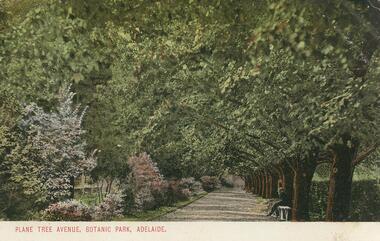
Postcard - GLADYS DEAN COLLECTION: POSTCARD, 1906 - 1908
Coloured photographic postcard with 1cm white border at bottom edge. Image depicts an avenue of plane trees opposite a flower border. A person is seated on a white bench on the right hand side of the avenue. The words Plane Tree Avenue, Botanic Park, Adelaide are printed in red in the border. On the reverse, the words South Australia Post Card are printed with a map of Australia at the top. Card is addressed to Miss R Dean Golden Square Victoria and a one penny stamp is affixed.South Australia Post Cardpostcard -
 Bendigo Historical Society Inc.
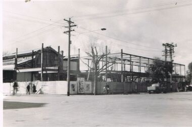
Photograph - S.E.C. VICTORIA, 1939
Photograph - black and white. The new SEC building still under construction. The 'old market building' can be seen to the left of the photo. Man on bicycle in dark clothing, man in black clothing walking to the right, lady in dark clothing walking to the left, light post with three cross bars and street light, advertising material displayed on corner section of fence, man in black standing over bhis bicycle to right of tree, dark colour utility vehicle parked in williamson street, twin power poles connected with 5 or six cross bars, vehicle angle parked in front of utility. Rear of photo has stamped name of the developer of the photo printed by Oliver's Bendigo. Number 79 witten in pencil.Printed by Olivers, Bendigo.organization, public utility, electricity company, s.e.c. victoria. 1939. bendigo. -
 Hume City Civic Collection
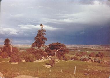
Photograph, September 1994
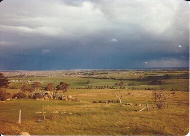
Woodlands Park complex which includes 'Cumberland' and 'Dundonald' ruins and the Gellibrand Hill Quarries was acquired by the Victorian State Government in 1978 and is managed by Parks Victoria.A view taken from Gellibrand Hill looking east towards the developing suburb of Greenvale. There are small rocky outcrops in the foreground and a clump of conifers and cypress trees in the middle. The sky is very overcast and a range of mountains can be seen across the skyline. Coloured photograph with rounded corners and matt finish.woodlands park, gellibrand hill, greene, william pomeroy, anne, george evans collection -
 Hume City Civic Collection
Photograph, September 1994
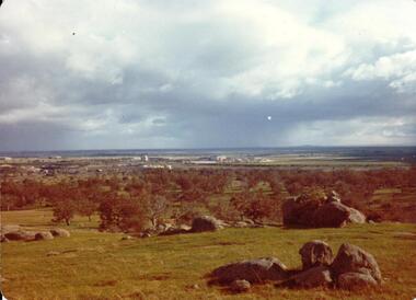
Woodlands Park complex which includes 'Cumberland' and 'Dundonald' ruins and the Gellibrand Hill Quarries was acquired by the Victorian State Government in 1978 and is managed by Parks Victoria.A view looking west towards the outer limits of the Tullamarine Airport taken from Gellibrand Hill. There is a small rocky outcrop in the middle of the photograph and trees are on the RHS of the image. Coloured photograph with rounded corners and matt finish.woodlands park, gellibrand hill, greene, william pomeroy, anne, george evans collection -
 Hume City Civic Collection
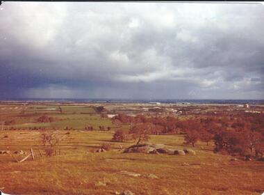
Photograph, September 1994
Woodlands Park complex which includes 'Cumberland' and 'Dundonald' ruins and the Gellibrand Hill Quarries was acquired by the Victorian State Government in 1978 and is managed by Parks Victoria.A view taken from Gellibrand Hill looking east towards the expanding suburb of Broadmeadows. Apart from a few rocky outcrops and small trees the open grassland slopes away to a small line of conifers. Coloured photograph with rounded corners and matt finish.woodlands park, gellibrand hill, greene, william pomeroy, anne, george evans collection -
 Hume City Civic Collection
Photograph, Sep-94
Woodlands Park complex which includes 'Cumberland' and 'Dundonald' ruins and the Gellibrand Hill Quarries was acquired by the Victorian State Government in 1978 and is managed by Parks Victoria.A view taken from Gellibrand Hill looking towards the recently constructed Tullamarine (Melbourne) Airport. The airport buildings are just beyond an outcrop of trees. Four rocky outcrops are spread around the foreground. Coloured photograph with rounded corners and matt finish.woodlands park, gellibrand hill, greene, william pomeroy, anne, george evans collection -
 Hume City Civic Collection
Photograph, Sep-94
Woodlands Park complex which includes 'Cumberland' and 'Dundonald' ruins and the Gellibrand Hill Quarries was acquired by the Victorian State Government in 1978 and is managed by Parks Victoria.A view taken from Gellibrand Hill looking northwest. The open grassed area in the foreground is dotted with a number of rocky outcrops with conifers and cypress trees in the background. There are a few buildings in the distance.Coloured photograph with rounded corners and matt finish.woodlands park, gellibrand hill, greene, william pomeroy, anne, george evans collection -
 Hume City Civic Collection
Photograph, c1970s
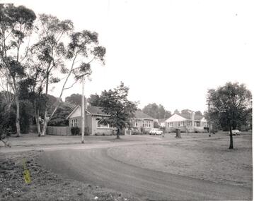
A number of houses were built within the Sunbury Asylum grounds to house administrators and staff, and their families, who worked at the asylum. After the asylum was closed down and the main asylum buildings were taken over by Victoria University, the surrounding land was developed for housing by the Urban Land Authority, the administrators houses were demolished.A black and white photograph of two bungalow style houses built along a formed but unsurfaced road. A Mini-minor car is parked on the grass outside the first house and a Holden sedan is parked by the curb outside the other house. There are trees growing along the nature-strip and in the background.Written on the back in penci: 1139-8lsunbury asylum, wishart, chas. h., george evans collection