Showing 202 items
matching walking tracks
-
 Lorne Historical Society
Pamphlet - Tourist pamphlet Lorne, Lorne Victoria Australia
... attractions,; the Main Street, tennis courts, Erskine River, walking... River, walking tracks and the George River with the phrase ...Victorian Railways printed a series of brochures publicizing holiday destinations.A folded paper souvenir pamphlet. The cover is a colored picture of Lorne from Scotsman’s Hill with two bathing suited young women in the foreground, and a blurb extolling the virtues of Lorne. On the back is a red, yellow and blue map of Lorne and district. Inside are eight black and white photographs of Lorne attractions,; the Main Street, tennis courts, Erskine River, walking tracks and the George River with the phrase ,” The resort that embraces everything for the perfect holiday.”souvenirs, pamphlets, victorian railways, -
 Marysville & District Historical Society
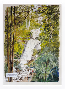
Postcard (item) - Colour postcard, David Williams, Steavenson's Falls Near Marysville, 2010
... in Victoria. The painting shows people walking along the track... walking along the track to the falls. Steavenson's Falls Near ...A watercolour painting of Steavenson Falls in Marysville in Victoria. A watercolour painting of Steavenson Falls in Marysville in Victoria.The Steavenson Falls is named after the Victorian Assistant Commissioner of Roads and Bridges, John Steavenson who arrived in Victoria in the early 1860s.David Williams '10steavenson's falls, steavenson falls, marysville, victoria, waterfalls, postcard, souvenir, john steavenson, david williams -
 Kiewa Valley Historical Society
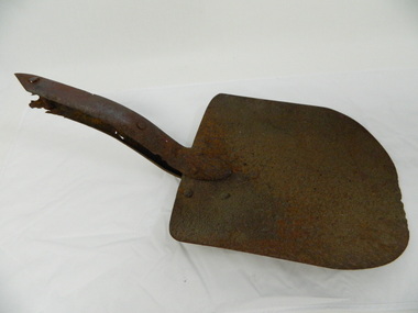
Shovel head - Fainter Falls
... shovel. fainters falls. bogong. walking track. fire track...The Fainter Falls Walking Track was originally accessible... The Fainter Falls Walking Track was originally accessible via a fire ...The Fainter Falls Walking Track was originally accessible via a fire fighting access trail, which was used by fire-fighters putting out spot fires caused by lightening strikes. The fires in the summer of 2003, highlighted the beauty of this area and provided the residents with the opportunity to consider the redevelopment of the trail. Work to establish a 700 metre grade 2 walking trail with a 50 metre grade 3 extension trail to the Falls began in 2005. It also includes 3 observation decks, a bridge over a creek crossing, car parking and interpretative signage.The shovel was found during work on the Fainter Falls track. It was left there some time ago by a previous visitor to the Falls indicating that the Falls were accessible and attracted visitors many years ago.Rusty metal shovel head curved on each side and rounded at the front. At the back of the blade it is attached on top with 3 nails to the top piece. The top metal piece overlaps the blade by 6.5 cm longitudinally x 5 cm across. On the back the metal piece overlaps the blade by 12 cm both longitudinally and across the handle end but tapers to a point. It has 6 nails attaching it. Both metal pieces are attached to the blade and curve parallel and around so that a wooden handle would fit between them. This would have 2 nails passing through both metal pieces and the handle. (The handle is missing.) shovel. fainters falls. bogong. walking track. fire track. water. -
 Kiewa Valley Historical Society
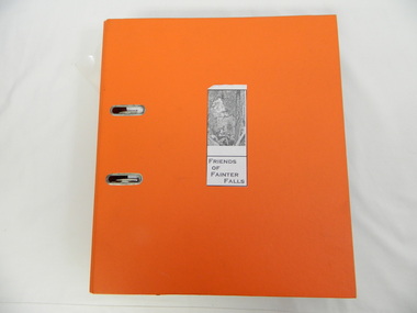
Folder - Fainter Falls, 2003 - 2008
... fainter falls. bogong. walking trail. fire track. kiewa...The Fainter Falls Walking Track was originally accessible... The Fainter Falls Walking Track was originally accessible via a fire ...The Fainter Falls Walking Track was originally accessible via a fire fighting access trail, which was used by fire fighters putting out spot fires caused by lightening strikes. The fires in the summer of 2003 highlighted the beauty of the area and provided the residents with the opportunity to consider the redevelopment of the trail. Work to establish a 700 metre grade 2 walking trail with a 50 metre grade 3 extension trail to the Falls began in 2005. It also includes 3 observation decks, a bridge over a creek crossing, car parking and interpretive signage.A Friends of Fainter Falls committee was formed to work towards the construction of a track to Fainter Falls. The contents of this folder is evidence of how a local community achieved its goals for such a project in 2003 - 2008.Large orange lever arch folder bound with 2 rings. Contains the history of the redevelopment of the Fainter Falls track 2003 - completion at the end of 2008. It is divided into: Funding Proposals. Correspondence Inwards & Outwards. Minutes and Letters of Support. Inserted separately in a large white and yellow Express Post envelope is additional information including chronology, minutes, newspaper cuttings Inserted separately is the 'Small Towns Development Fund' Application Form 2006.Cover blankfainter falls. bogong. walking trail. fire track. kiewa valley community. -
 Mt Dandenong & District Historical Society Inc.
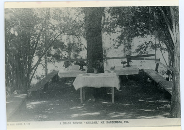
Photograph, Tea Tables at "Shiloah"
... capitalised on this by setting out walking tracks through the ferns... and his family capitalised on this by setting out walking tracks ...Originally the home of Isaac Jeeves, brother of Ellis Jeeves, ‘Shiloah’ was enlarged to take guests in the early 1900s. It was situated close to a beautiful fern gully and Isaac and his family capitalised on this by setting out walking tracks through the ferns. They charged 1/- to walk through and this included afternoon tea in a garden setting. ‘Shiloah’ was a popular tourist attraction but the making of the Olinda Creek Road destroyed the fern gullies and, by the 1930s, it was all finished. This photograph shows the tea tables at 'Shiloah' where Selina Jeeves and her daughter Elsie served afternoon tea to visitors.Black and white photograph taken from a Rose Series postcard showing tables set up in an exterior courtyard with bench seating.On front - Rose Series P. 170 A SHADY BOWER "SHILOAH" MT DANDENONG. VIC.shiloah, isaac jeeves the younger, guest house, afternoon tea, ferns, selina jeeves, elsie jeeves -
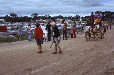 Stawell Historical Society Inc
Slide, Ian McCann, Stawell Show
... Two ladies walking across the trotting track... grampians Stawell Show Two ladies walking across the trotting track ...Two ladies walking across the trotting track, with a Stagecoach approaching, with passangers. stawell show -
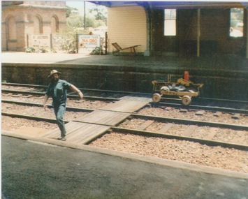 Sunbury Family History and Heritage Society Inc.
Photograph, c 1970
... A coloured photograph of a maintenance man walking across... photograph of a maintenance man walking across a railway track ...A railway maintenance person is crossing the railway tracks from Platform 2 to Platform 1 at Sunbury Station. There is a partial view of the historic brick water tower, which was used by the steam engines, on Platform 2.A coloured photograph of a maintenance man walking across a railway track at a station.sunbury railway station, water towers -
 Mt Dandenong & District Historical Society Inc.
Photograph, "Shiloah" 1913
... and Isaac and his family capitalised on this by setting out walking... and Isaac and his family capitalised on this by setting out walking ...'Shiloah' was the home of Isaac Jeeves the younger - son of Isaac Jeeves the Valley Pioneer and brother of Ellis Jeeves. Isaac built this house himself using local timber he cut and split. It was ready for his marriage to Selina Leach of Bayswater in 1886. ‘Shiloah' was enlarged to take guests in the early 1900s. It was situated close to a beautiful fern gully and Isaac and his family capitalised on this by setting out walking tracks through the ferns. They charged 1/- to walk through and this included afternoon tea in a garden setting. ‘Shiloah’ was a popular tourist attraction but the making of the Olinda Creek Road destroyed the fern gullies and, by the 1930s, it was all finished.Black and white photograph of wooden structure with two wings and a central verandah. Eight adults sitting or standing at the front.Handwritten on back by John Lundy-Clarke "Shiloah" 1913.isaac jeeves, isaac jeeves the younger, ellis jeeves, shiloah, guest house, guesthouse, selina leach, selina jeeves, olinda creek road -
Southern Sherbrooke Historical Society Inc.
Information folder - Lockwood House
... map of Doongalla walking tracks, hand-written on back... of Conservation, Forests & Lands, includes map of Doongalla walking tracks ...Folder containing items pertaining to the history of Lockwood House, Belgrave Heights. Contents: -notes, hand-written, on holidays in Belgrave Heights, 6 sheets on Ansett memo pad. -typescript, "Holidays In The Dandenongs" -printed sheets, "Doongala Forest Reserve", Dept of Conservation, Forests & Lands, includes map of Doongalla walking tracks, hand-written on back "Doongala/751 1717/Open week days except/Thursday./Open weekends by appointment" -5 Certificates of Title for parcels of land included in Lockwood Estate.lockwood house, elvery family, guesthouses -
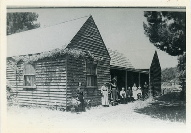
 Stawell Historical Society Inc
Book, N.A. McLennan, Back over the track of Time by N A McLennan, 1970
... Photo of a man walking along a track carrying a swag ... of a man walking along a track carrying a swag Back over the track ...A History of BanyeaGrey Card Cover with border insode of which is text and B/W Photo of a man walking along a track carrying a swag In Blue Ink Underlined: Banyana History Inside Border Back over the Track of Time Compiled and written by Neil A. McLennan 1970 Stawell Victoriastawell, mclennan family -
 Bendigo Historical Society Inc.
Document - LONG GULLY HISTORY GROUP COLLECTION: PROPOSED: HERCULES & ENERGETIC MINE PROJECT
... , The History Group wish to install a plaque on the Linear Park walking... Park walking track near Creeth Street Long Gully to acknowledge ...Letter to Barry Secombe, Manager Community Services, from George Ellis, for the Proposed: Hercules & Energetic Mine Project. Letter dated 21 June 2005 and printed on a brown Long Gully Neighbourhood Centre Inc letterhead .Mentioned in the letter, The History Group wish to install a plaque on the Linear Park walking track near Creeth Street Long Gully to acknowledge the site (not the Shaft) of the Hercules and Energetic Mine formally the Energetic Mine. It is also mentioned that Sir John Quick once worked at this mine before he went to University. There is a suggestion of where the plaque could be located.bendigo, history, long gully history group, the long gully history group - proposed: hercules & energetic mine project, long gully neighbourhood centre inc, barry secombe, city of greater bendigo, the long gully history group, energetic mine, sir john quick, bendigo evening news, prof geoffrey blainey, melbourne herald january 2nd 1986, george ellis -
 Benalla Art Gallery
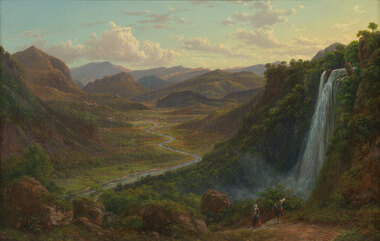
Painting, Eugene VON GUERARD, The fall of the Veliono near Terni with the view up the Valley of the River Nera, 1885
... walking down a track beside a waterfall towards a river. Gold... landscape with two figures walking down a track beside a waterfall ...Born: Vienna, Austria 1811; Arrived: Melbourne, Victoria, Australia 1852; Died: London, Middlesex England 1901RomanticismLedger Gift, 1984Rural valley and mountain landscape with two figures walking down a track beside a waterfall towards a river. Gold brushed gesso decorative edged timber frame.Recto: Signed and dated "Eug.V.Guérard / D. 85" in red oil in l.r.c of composition; Not titledpainting, landscape, river, cliff, mountain, figures, buildings, waterfall, sky, clouds -
 Marysville & District Historical Society
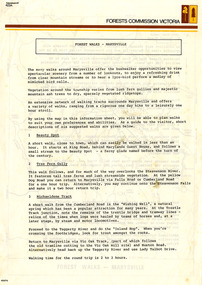
Flyer (Item) - Information Flyer, Forests Commission, Victoria, FOREST WALKS - MARYSVILLE, 1918-1983
... network of walking tracks surrounds Marysville and they offer... for forest purposes″. An extensive network of walking tracks ...An information flyer that was produced as a guide to the forest walks in and near Marysville by the Forests Commission of Victoria. The Forests Commission Victoria (FCV) was the main government authority responsible for management and protection of State forests in Victoria, Australia between 1918 and 1983. The Commission was responsible for ″forest policy, prevention and suppression of bushfires, issuing leases and licences, planting and thinning of forests, the development of plantations, reforestation, nurseries, forestry education, the development of commercial timber harvesting and marketing of produce, building and maintaining forest roads, provision of recreation facilities, protection of water, soils and wildlife, forest research and making recommendations on the acquisition or alienation of land for forest purposes″. An extensive network of walking tracks surrounds Marysville and they offer a variety of walks ranging in various levels of difficulty. This information flyer provides information such as the level of difficulty for six suggested walks around Marysville.An information flyer that was produced as a guide to the forest walks in and near Marysville by the Forests Commission of Victoria.marysville, victoria, australia, forest walks, forests commission victoria, beauty spot walk, tree fern gully walk, michaeldene track, keppel track, woods lookout track -
 Mt Dandenong & District Historical Society Inc.
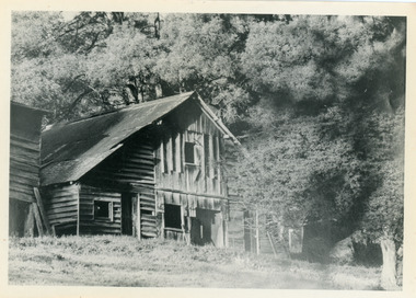
Photograph, Isaac Jeeves' Barn
... capitalised on this by setting out walking tracks through the ferns... capitalised on this by setting out walking tracks through the ferns ...Large barn built c1886 by Isaac Jeeves the younger on his property where the homestead 'Shiloah' stood. The barn was reputedly made from timbers split from only one messmate tree. Originally the home of Isaac Jeeves, brother of Ellis Jeeves, ‘Shiloah’ was enlarged to take guests in the early 1900s. It was situated close to a beautiful fern gully and Isaac and his family capitalised on this by setting out walking tracks through the ferns. They charged 1/- to walk through and this included afternoon tea in a garden setting. ‘Shiloah’ was a popular tourist attraction but the making of the Olinda Creek Road destroyed the fern gullies and, by the 1930s, it was all finished. John Lundy-Clarke grew up in the Kalorama/Mt Dandenong area and later in life (1972-74) began to write a comprehensive history of the area working from an original settlement map in an effort to cover all areas.Black and white photograph showing a large wooden structure surrounded by trees. Handwritten inscription on reverse by John Lundy-Clarke.Home of Isaac Jeeves the younger. Built about 1886 of timbers split from one messmate tree. Photo 1973isaac jeeves the younger, barn, kalorama, shiloah, messmate -
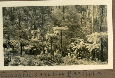 Mt Dandenong & District Historical Society Inc.
Photograph
... the Olinda Falls. The area has been a popular walking track...-and-the-dandenong-ranges Lyre Bird Gully and Lyre Bird Gully Track run ...Lyre Bird Gully and Lyre Bird Gully Track run alongside the Olinda Falls. The area has been a popular walking track in the from the 1920s onwards. The photograph is from the album of Ivy Child. Ivy May Child (1910 – 1989) was the daughter of Arthur Edward (Ted) Child (1878 – 1964) and Ethel May Madden (1888 – 1970). Ted Child was the son of Matthew Francis Child (1839 – 1933) and Martha Jeeves (1857 – 1926). He was the grandson of one of the early pioneers Francis Child. Ivy grew up on the family property on Childs Road and took many photographs. Most of these are glued into her photo album. The album covered the years from c1927 – 1932. Ivy married Henry William Burgess (1906 – 1968) in 1944. The photographs remain in their original state in the album with individual copies made. Black and white photograph showing a row of tree ferns in the foreground with bush behind.Written below photograph in album: OLINDA FALLS AND LYRE BIRD GULLYolinda falls, falls, lyrebird, lyrebird gully, lyrebird track -
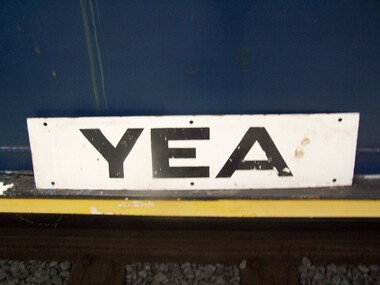 Puffing Billy Railway
Station Sign - Yea
... station in Yea, Victoria, Australia. The tracks have been removed..., skatepark, walking track, community reserve and includes Rotary Park ...Station Sign - Yea Yea Station Opened 16 November 1883 Closed 8 November 1978 Yea is a former railway station in Yea, Victoria, Australia. The tracks have been removed and the reserve has been turned into The Yea Railway Park consisting of the historic railway station and eleven acres of parkland. It has a picnic shelter, barbecue, toilets, playground, skatepark, walking track, community reserve and includes Rotary Park. The station building houses Blackthorn Textiles (a privately run craft shop). Also on the site are the former goods sheds which are available for hire for varied functions. The Yea Country Market is held in the park on the first Saturday of each month and local artists hold an exhibition and sale in the goods sheds each Easter. The site is listed on the Victorian Heritage Register ref: https://en.wikipedia.org/wiki/Yea_railway_station photo at http://vhd.heritagecouncil.vic.gov.au/vhd-images/places/000/078/092.jpg Historic - Victorian Railways Station sign used at Yea StationStation Sign - Yea Metal rectangle Station Name Sign with white enamel back ground and black lettersYeapuffing billy, station sign, yea station -
Clunes Museum
Document - DOCUMENTS
... CLUNES WALKING TRACK WITH DETAILS OF WORK TO BE UNDERTAKEN 2005... WALKING TRACK WITH DETAILS OF WORK TO BE UNDERTAKEN 2005 .4 "TAKE ....1 DILAPIDATION ASSESSMENT AND RESTORATION PROPOSAL FOR THE QUEENS PARK FOUNTAIN AT CLUNES, AUGUST 1993 .2 CRESWICK CREEK WALK PROJECT 2005 WITH CORRESPONDENCE FROM MICHAEL CHESHIRE .3 CLUNES WALKING TRACK WITH DETAILS OF WORK TO BE UNDERTAKEN 2005 .4 "TAKE BACK THE CREEK" COMMUNITY MEETING - AGENDA FOR MEETING 8/8/2005 .5 ACCOUNT FOR CRUSHED ROCK AND GRANITE SAND 17/05/2005 .6 MAP OF HEPBURN SHIRE SHOWING LANDCARE GROUPS .7 CTDA LETTER DATED 14/06/2005 REGARDING PLANNING WORKSHOP .8 QUEENS PARK FENCE PROJECT REPORT 2003 .9 MINUTES OF GENERAL MEETING OF CLUNES LANDCARE GROUP FROM 23/07/2002 TO 12/05/2005 .clunes landcare group, queens park fountain, creswick creek walk -
 Phillip Island and District Historical Society Inc.
Photograph, Lovers Walk, Cowes, Phillip Island, ?
... , Cowes, adjacent to the beach, towards Rose Street. Man walking... walking away on track. A wooden railing extending from wooden ...Lovers Walk extending from the east end of The Esplanade, Cowes, adjacent to the beach, towards Rose Street. Man walking away on track. A wooden railing extending from wooden bridge in foreground to diminishing track and back drop of trees.Lovers Walk track, wooden bridge in foregroundlocal history, photographs, lovers walk, cowes, black & white photograph, noel ayton collection, bruce bennett -
 Sunbury Family History and Heritage Society Inc.
Photograph, School Camp, 1988
... walking along a bush track, in single file with an adult holding... of a group of children walking along a bush track, in single file ...The children were attending a school camp at Beechworth and on this particular day, they were hiking for one of the activities.A non-digital coloured photograph of a group of children walking along a bush track, in single file with an adult holding a camera bringing up the rear. school camps, hiking, beechworth -
 Ithacan Historical Society
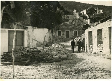
Photograph, Ithaca earthquake, 1953
... in the foreground. Two men are walking along a track looking.... Two men are walking along a track looking at the destruction ...The photograph was taken after the massive earthquakes of 1953 which caused widespread destruction across Ithaca and other Ionian Islands. Many of the buildings destroyed in the earthquake could not be rebuilt and some parts of the villages became uninhabitable. This event brought about the largest mass migration from the island and a further wave of Ithacan migration to countries, such as Australia and South Africa, where relatives had already settled. The Ithacan Philanthropic Society established an Earthquake Appeal to assist their compatriots.A black and white photograph showing widespread damage done in the aftermath of an earthquake. Many houses are in ruins and there are two heaps of rubble comprising timber and metal and concrete in the foreground. Two men are walking along a track looking at the destruction in the village. -
 Lakes Entrance Historical Society
Photograph - Johnsonville School, 1984
... and Dominique (Dommie) Spiller plus children walking along bush track... walking along bush track, pine log hand rail, at Mississippi Creek ...Black and white photograph of two adults Lyn Winnett and Dominique (Dommie) Spiller plus children walking along bush track, pine log hand rail, at Mississippi Creek Track, on primary school picnic day. Jonsonville Victoriaschools, activities -
 Kiewa Valley Historical Society
Photograph - Mt Bogong - Tawonga, 06/05/1937
... kilometres (19 mi) by road and walking track or 12 kilometres (7.5 mi... kilometres (19 mi) by road and walking track or 12 kilometres (7.5 mi ...Mount Bogong located in the Alpine National Park and part of the Victorian Alps of the Great Dividing Range, is the highest mountain in Victoria, Australia, at 1,986 metres (6,516 ft) above sea level. The Big River separates the massif of the mountain from the Bogong High Plains to the south. From the nearby town of Mount Beauty to its summit, Mount Bogong rises more than 1,600 metres (5,200 ft), thus making it one of the highest peaks in Australia not only in terms of its elevation above sea level, but also in terms of actual base-to-summit prominence. Mount Bogong is a popular backcountry skiing mountain through winter but only has snow for the mid winter-spring months. It is around 30 kilometres (19 mi) by road and walking track or 12 kilometres (7.5 mi) direct to Mount Beauty. Falls Creek and Mount Hotham ski resorts are also nearby. Camping is relatively safe below the tree line but the summit ridgeline is very exposed. Emergency shelter is also available at Bivouac Hut on the Staircase Spur, and at Cleve Cole, above Camp Creek on the broad ridge to the south of the summit, and Michells Hut on the Eskdale Spur. Mt Bogong is a popular recreational venue in the Kiewa Valley for back country skiing and bush walking and is a favourite with sightseers and popular subject for photographersBlack and white photograph of Mt bogong taken from Tawonga - Thursday May 6th, 1937Handwritten on back of photograph. Thursday May 6th, 1937. Mt Bogong Tawongamt bogong, tawonga, kiewa valley -
 Parks Victoria - Mount Buffalo Chalet
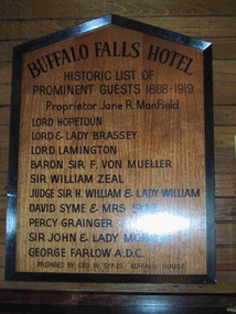
Plaque, "Buffalo Falls Hotel / Historic list of prominent guests 1888-1919"
... was constructed opposite the newly opened 'Staker's Track', a walking... opposite the newly opened 'Staker's Track', a walking track , now ...Possibly predates Chalet. ".There is also a wooden plaque displaying the names of notable guests who stayed at the Buffalo Falls Hotel that once stood at the foot of the mountain. the pioneering Manfield family opened this early hotel in the late 1880's and soon began taking visitors on walking treks up onto the plateau." (Pg 84 Historica, 2011). The Buffalo Falls Hotel was originally known as The Buffalo Falls Temperance Hotel and was built in 1888 by James Manfield. His daughter Alice became well known as a Mt Buffalo guide and was renowned for her mountain knowledge as well as for her distinctive alpine pant suit. The Hotel was constructed opposite the newly opened 'Staker's Track', a walking track , now known as the "Big Walk" was, a steep 6 hour walk, which nevertheless opened the mountain up to early tourism, attracting leading figures from Melbourne Society as well as significant artists, Naturalists and Scientists eager to explore and experience the unique scenery and geological features of the Mountain. Baron Von Mueller as Government botanist was one of the first white men to ascend to the plateau in 1853, collecting alpine specimens . Each of the names on this honor roll were significant cultural and society figures of Victorian/Edwardian Melbourne .Listed in Draft Inventory of Significant Items. Appendix A3. Framed Photographs, Pictures, etc. (Pg 165, Historica, 2011)Wooden plaque with black painted inscription, framed in black painted wood. Plaque is peaked at the top."BUFFALO FALLS HOTEL.... Historic list of prominent guests 1888-1919. Proprietor Jane R. Manfield. Lord Hopetoun. Lord & Lady Brassey. Lord Lamington. Baron Sir F. Von Mueller. Sir William Zeal. Judge Sir H. William & Lady William. David Syme & Mrs Syme. Percy Grainger. Sir John & Lady Monash. George Farlow A.D.C. Prepared by Geo. W. Sykes "Buffalo House'." -
 Parks Victoria - Mount Buffalo Chalet
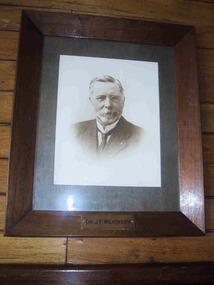
Photograph, " DR J.F.WILKINSON"
... by the Alpine club funded the Staker's walking track, the first easily... the Staker's walking track, the first easily accessible route up ...'There are also a number of framed portraits, including those of...Dr. John Wilkinson, a doctor who started a practise in Bright in the late 1880's and helped develop the tourist potential of the Mount Buffalo Plateau. " (Pg 84, Historica, 2011) Dr John .F. Wilkinson was a significant figure in the pioneering of tourism at Mt Buffalo. A Doctor and resident of Bright, he and W.A. Staker were the founder members of the Bright Alpine Club formed in 1887 to promote the natural attractions of the Buffalo plateau. " They form the Alpine Club and charge a membership fee for guiding people up the mountain (led by official guides Bill Weston and Edward Carlisle). this is matched by a grant from the local shire council.... They advertise in the Argus and promote the Australian Alps, Bright district as "The Switzerland of Victoria'. Mt Buffalo, with the railways nearby, is the most accessible snowfield and becomes 'the cradle of skiing in Victoria'." (Pg 179 Historica . 2011) The initial funds raised by the Alpine club funded the Staker's walking track, the first easily accessible route up the mountain. . They engaged the services of early Victorian photographer Nicholas Caire, whose scenic photographs helped to promote the beauty of the mountain. The efforts of these gentlemen culminated in securing 2.800 acres for the one of the first National Parks in Victoria, 1898. Listed in Draft Inventory of significant Items. Framed sepia photograph. Grey mount in wooden frame. Portrait of Dr.J.F Wilkinson. Brass name plaque at base of frame. Hand finished / highlighted in places." DR J.F.WILKINSON" -
 Otway Districts Historical Society
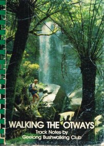
Book, Geelong Bushwalking Club Inc, Walking the Otways, November 1986
... Walking the Otways. Track notes compiled by the Geelong...; bushwalking; Walking the Otways. Track notes compiled by the Geelong ...The Otways area of Victoria, at the time of writing, was an underused area for bushwalking. In the past, people have considered these ranges unsuited for walking because of the thick forest cover, cold and muddy conditions for much of the year, and the steep slopes. Some of the perceived difficulties are actually attractions and that it is possible to enjoy them with a forward planning and up-to-date information to guide the walker.The Geelong Bushwalking Club have included some useful but brief articles on basic aspects of bushwalking.Walking the Otways. Track notes compiled by the Geelong Bushwalking Club. Graeme Allen (ed.); John Van Gemert (maps, photographs). 1st ed. Geelong Bushwalking Club; Geelong (Vic); November 1986. 148 p.; illus, maps. Soft cover.otways; bushwalking; -
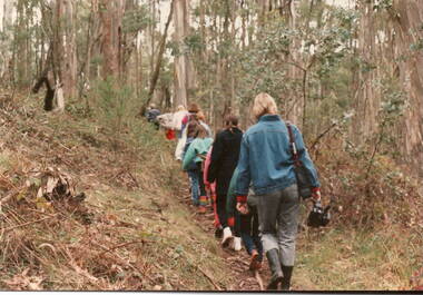
 Southern Sherbrooke Historical Society Inc.
Photograph
... of people in summer attire are walking along an open track between... in summer attire are walking along an open track between treeferns ...Black and white photo of Sherbrooke Forest in 1968. A group of people in summer attire are walking along an open track between treeferns and tall gum trees. Created for the Australian News and Information Bureau. -
 Tatura Irrigation & Wartime Camps Museum
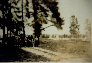
Photograph, Guntram Gohl Funeral
... of picture) walking along a dirt track with pine trees either side... (to the left of picture) walking along a dirt track with pine trees ...Guntram Gohl was an internee with his family in Camp 3 Rushworth. He died on the 28 September 1945 and was buried in Tatura Cemetery.Sepia photograph of a group of people (to the left of picture) walking along a dirt track with pine trees either side of the track. A hearse is following the people. The right side of the picture shows graves. Photograph is blurry.guntram gohl, camp 3 rushworth, tatura cemetery, internee deaths -
 Ballarat Tramway Museum
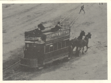
Photograph - Digital image, Keith Kings, c1903
... walking across the track. ... right hand corner walking across the track. Photograph Digital ...Yields information about the Ballaarat Tramway Company tramcars.Digital image from the Wal Jack Ballarat Album of a horse tram travelling from Grenville St into Sturt St. Image re-photographed from a black and white postcard - see Reg Item btm2437 - a coloured postcard. Note the person in the top right hand corner walking across the track. trams, tramways, horse trams, sturt st, grenville st -
 Tramways/East Melbourne RSL Sub Branch - RSL Victoria Listing id: 27511
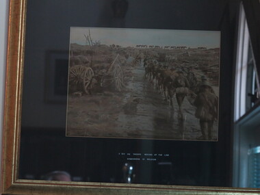
Photograph - Photo, Moving Up The Lines
... frame. Image shows WW1 soldiers walking along a muddy track... walking along a muddy track wearing full kit. Packhorses can ...A Black & White photo mounted on dark card in a light wood frame. Image shows WW1 soldiers walking along a muddy track wearing full kit. Packhorses can be seen in the background, and landscape is littered with debris of war. 2nd Div. HQ Troop Moving Up The Line Somewhere in Belguim inscribed in white ink on mat boardbelgium, cart, second division headquarter troops, horses, ww1, australian soldiers -
 Bendigo Military Museum
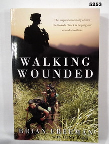
Book - BOOK, THE KOKODA TRACK & WOUNDED SOLDIERS, Brian FREEMAN with Tony PARK, "Walking Wounded", 2013
... walking along a track. Back - a group crossing a water course... - a group walking along a track. Back - a group crossing a water ..."Walking Wounded/ The Inspirational Story of how/ the Kokoda Track is helping our/ wounded soldiers"Soft cover book. Soft cover - cardboard, white, gold and black print on front, spine and back. Illustrated in colour photographs - front top silhouette of soldier. Bottom - a group walking along a track. Back - a group crossing a water course. 265 pages - paper, - cut, plain, off white. Illustrated colour photographs.books, history, ww2, new guinea