Showing 69 items matching "warrnambool breakwater construction"
-
 Flagstaff Hill Maritime Museum and Village
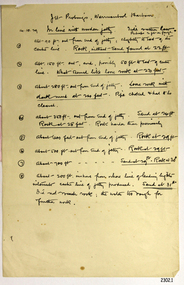
Document - Report, Jet Probings, Warrnambool Harbour, 16-10-1929
This report lists the depths of water and the consistency of the seabed surrounding the Warrnambool Harbour in October 1929, The information, often referred to as 'soundings', was obtained by Jet Probing,. In earlier days a lead line was used to perform a similar task. The author of the document is unknown. Jet Probing is a method used for underwater archaeology, cable installation and coastal engineering. A jet probe is a machine that produces a strong jet of water that penetrates the layers of sediment on the seabed, determining their depth, thickness and consistency. It provides a survey of the seabed and can be used as an aid to engineering design and construction. The report mentions lining up with the wooden jetty, the end of the breakwater and the leading lights. It mentions sand, loose rock and rock. It tells of stopping work due to the water being too rough, the pipe choking, difficulty in connecting pipes, and pipe joint breaking as it tried to get through the sand, The report in the document is significant for its connection with the Warrnambool Harbour, Warrnambool Breakwater, Warrnambool Jetty and Lady Bay. The report gives figures for the depth and consistency of the water and seabed at a particular point in time and can be used to compart with similar figures taken at different times. The results could determine plans for future engineering works.Report, titled 'Jet Probings, Warrnambool Harbour'. Two pages of cream coloured paper with hand written notes in pen and ink. Report covers three days of Jet Probings, with resulting figures and comments, for the depths of the surroundings of the Warrnambool Harbour. The report is in point form, with some underlining. Dates of recordings are 14-10-29, 15-10-29 and 16-10-29. (1929) The situation of the harbour had become a real problem by 1910 and required continuous dredging. In 1914 the Breakwater was extended but proved to be a failure because the work began to subside and by 1920 about two thirds of the harbour was silted up. Alterations made in the 1920's increased the silting problem. The soundings and Jet Probings were done after the Royal Commission of 1923, when the damaged stonework on the seaward side of the Warrnambool Breakwater, caused by the action of the sea, was the subject of enquiry. A conference between the Public Works, Water Commission and the Harbour Trust concluded that it would less costly to make repairs to prevent further damage rather than replaced the damage portion of the wall. A contract was raised in late 1924 to deposit rubble on the damaged side of the breakwater to minimise the Southern Ocean’s destructive action and work had started by August 1925. By the 1940's the harbour was no longer used. More alterations were made in the 1950's and 1960's. document, depth, warrnambool harbour, 1929, soundings, jet probe, jet probing, seabed, map of seabed, underwater engineering, warrnambool jetty, warrnambool breakwater, breakwater upgrade, leading lights, chart the harbour, flagstaff hill, warrnambool, flagstaff hill maritime museum & village, maritime museum, maritime village, shipwreck coast, lady bay, port of warrnambool, breakwater, jetty, pier, vhr h2024, royal commission, 1923, public works, water commission, harbour trust, victorian harbours -
 Flagstaff Hill Maritime Museum and Village
Document - Navigation Chart, Admiralty Office, Lady Bay and Warrnambool Harbour, 1893
This navigation cart of Lady Bay and Warrnambool Harbour was originally surveyed in 1870 but this version includes the update for magnetic variation in 1893. Since the printing of the chart several annotations have been added. These include an additional stamp dated 15-8-1910, a handwritten comment across the top of the page dated August 1910, and another handwritten comment regarding the ‘Proposed Extension of Dock’ dated 19-2-1925, plus connected drawings, notes and figures. The 1925 proposal on this chart may have been a reaction to the Royal Commission of 1923, when the damaged stonework on the seaward side of the Warrnambool Breakwater, caused by the action of the sea, was the subject of enquiry. A conference between the Public Works, Water Commission and the Harbour Trust concluded that it would less costly to make repairs to prevent further damage rather than replaced the damage portion of the wall. A contract was raised in late 1924 to deposit rubble on the damaged side of the breakwater to minimise the Southern Ocean’s destructive action and work had started by August 1925. The Breakwater construction had begun in 1874 and was completed in 1890. The Victorian Government had commissioned Sir John Coode, a British harbour engineer, to present a plan to complete the Warrnambool Breakwater but his original plan was too expensive. He prepared a revised plan for a shorter structure. The construction proved to be too short to protect adequately from the weather and didn't allow enough depth for larger vessels to come into port. The decreasing trade was further affected by siltation in the bay due to the breakwater, and the completion of the railway line. The situation of the harbour became a real problem by 1910 and required continuous dredging. In 1914 the Breakwater was extended but proved to be a failure because the work began to subside and by 1920 about two thirds of the harbour was silted up. Alterations made in the 1920's increased the silting problem and by the 1940's the harbour was no longer used. More alterations were made in the 1950's and 1960's. This chart is significant for its strong connection to the maritime history of Warrnambool Harbour and Lady Bay and the Warrnambool Breakwater. The Warrnambool Breakwater is registered as a place of significance on the Victorian Heritage Database (VHR H2024). The Warrnambool Breakwater is one of the most important late 19th century maritime engineering projects in Victoria and significant in the development of Victorian coastal shipping. It is also significant for its connection with British harbour engineer, Sir John Coode. The chart is a historical record of structures existing in 1893; the Warrnambool Jetties, Warrnambool Breakwater in Lady Bay, the leading lights (lighthouses), streets, roads, bridges and many buildings. It also shows the lay of the land and seabed. Navigation Chart: Lady Bay and Warrnambool Harbour, Australia - South Coast - Victoria. Surveyed by Nav. Lieut. H.J. Stanley, R.N., 1870. Updated for Magnetic Variation, 1893. The rectangular chart is printed on heavy cream paper. Stamps are shaped rectangular, oval and round. Around the Breakwater and Jetty area are handwritten notes, dotted and joined lines, numbers and signatures, and shading of red and green. The chart shows the surrounds of Warrnambool Harbour, Lady Bay, the Breakwater and Jetty, roads, bridges and the streets in Warrnambool. It has sounding details, and angles of line from the leading lights.Stamp, rectangular, including "AUG 1910" Stamp, double oval " - - - -CHART" Stamp, hand drawn, red circle, with "B" inside Hand written note "22-8-1910 - - - - - of surveying C. Ca - - - request of 15-8-10 [initials] " Notes and lines in red pen, including a grid of sounding numbers: "1300" "1050" "1200" "Possible Extension of Dock" "19-2-25" "Dock Dredged to 20 Ft" Notes and lines in blue pen "Extension of Dock to accommodate vessels drawing 20 Feet" and "Light not visible south of this line" Red dots (4) with yellow highlight at both leading lights, breakwater and jettyflagstaff hill, warrnambool, flagstaff hill maritime museum & village, maritime museum, maritime village, shipwreck coast, map, chart, navigation chart, plan, lady bay, warrnambool harbour, port of warrnambool, breakwater, jetty, pier, dock extension, proposed extension, vhr h2024, 1870, 1893, 1910, 1925, warrnambool town late 1800s, warrnambool streets late 1800s royal commission, 1923, public works, water commission, harbour trust, victorian harbours, sir jon coode -
 Flagstaff Hill Maritime Museum and Village
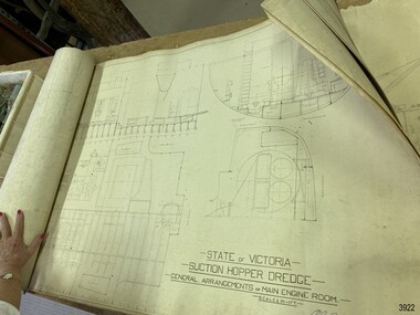
Plan - Vessel, Public Works Department (P.W.D.), Matthew Flinders I, 8-11-1911
These plans are line drawings by the State of Victoria for a Suction Hopper Dredge, which used a suction pump to bring up material from the bottom of a body of water. The plans are contained in a box from the Public Works Department, Ports and Harbours Division in Melbourne, which in the year 1910 was responsible for the dredging operations of coastal ports and harbours, and inland waterways. The stamped signature is that of Arthur Edward Cutler, Chief Engineer, Public Works Department of New South Wales. The steel steamer Matthew Flinders was constructed by Morts Dock & Engineering Co Ltd in Sydney, New South Wales. Identified as Ship No. 40 by the ship builders, this dredge, had twin screw engines that were made in Sydney. Its gross tonnage was 1180. It was launched on July 15th, 1916, and registered by the owner, Department of Public Works in Victoria, at the Port of Melbourne in 1917. Unlike bucket dredges, the Matthew Flinders did not use permanent moorings but instead had bow and stern anchors. It travelled forward on the bow anchor, taking up a strip of even-depth wilt from the bed below. A local newspaper noted that the Matthew Flinders has many advantages that were especially useful for its work at Warrnambool. Warrnambool Harbour had been experiencing silting and sanding for many years. The problem continued even after the construction of the Breakwater in 1890, which was overseen by New Zealand engineer Arthur Dudley Dobson. Melbourne’s Department of Ports and Harbours sent the new Matthew Flinders to dredge the heavy silting in the Warrnambool Harbour in May 1919. This work was previously done by the smaller dredge, the Pioneer. However, after a month of work, the Matthew Flinders was returned to Melbourne for alterations to make it suitable for work in the heavy seas it experienced at Warrnambool. Both dredges were sent up from Melbourne when required over the years to periodically attend to the silting in the Harbour, but the Matthew Flinders was preferred because of its efficiency. It was still dredging the Harbour even in July 1938. The ship’s original master was J G Rosney. In 1923 the master in charge was Captain Dunbar. In 1930 the dredges were no longer required as the Harbour was no longer suitable as port.These plans are significant for their close association with the suction hopper dredge, the Matthew Flinders I, which was call upon often to remove the silting of Warrnambool Harbour and allow shipping to continue in the Port of Warrnambool until 1930, when the Port of Warrnambool ceased to be suitable as a port. The work done by the Matthew Flinders is significant for its association with the Warrnambool Breakwater and the on-going issues with the silting of the Harbour. Plans with line drawings for the suction hopper dredge Matthew Flinders, rolled, in open-top wooden box. Created for the Public Works Department, Melbourne, Victoria. Stamped with signature and dated November I, 1911. Inscriptions: label on box, handwriting on box, drawings and outer layer of paper. Freighted by 1 Star, New Zealand Express Cargo.Signature stamp “A E Cutler” Date stamp “NOV 8 – 1911” Printed on one page “STATE OF VICTORIA / SUCTION HOPPER DREDGE / GENERAL ARRANGEMENTS OF MAIN ENGINE ROOM / SCALE 1/2 IN = 1 FT.” Label on box "1 [star symbol] / THE NEW ZEALA- - - / EXPRESS CAR - –“ Handwritten on base “PUBLIC WORKS / DEPARTMENT / - - LBOURNE” Handwritten in pencil on cover paper “MATTHEW Flinders”flagstaff hill, warrnambool, maritime village, maritime museum, flagstaff hill maritime museum & village, shipwreck coast, great ocean road, plan, line drawing, dredge, pioneer, steel steam ship, twin screw engines, a e cutler, arthur edward cutler, chief engineer, public works department, new south wales, nsw, 1911, state of victoria, suction hopper, main engine room, public works melbourne, warrnambool harbour, lady bay, sanding, silting, breakwater, morts dock & engineering co ltd, j g rosney, captain dunbar, ship no. 40, matthew flinders i, matthew flinders, 1 star, new zealand express cargo -
 Flagstaff Hill Maritime Museum and Village
Equipment - Anchor, John Trotman, 1852 to early 1900s
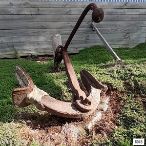
This Trotman’s pattern stock anchor is the southernmost anchor on display at Flagstaff Hill’s Anchor Graveyard. This large Trotman design anchor was patented in 1852 by John Trotman and was widely used on merchant ships. On April 15th 2001 around midday this anchor was raised from the seabed of Lady Bay, Warrnambool, by the crew from Birdon Dredging, who had been hired to dredge the Harbour. The spokesperson Steve Walker, who worked for the firm, said that the anchor and long chain were found after the chain became tangled in the cutter blade of the dredging equipment. The anchor was lifted from the water and onto the Breakwater then a front-end loader placed it onto a truck that then delivered it to Flagstaff Hill Maritime Museum & Village. Howard Nichol, Museum Manager at the time, had estimated the anchor to be up to 130 years old. The previous Museum Manager, Peter Ronald, who was also a diver, had identified the anchor as a Trotman’s type and similar to those used on some of the major wrecks in the region. According to Nicholl, Museum staff believed it was possible that the anchor is one of two used as a mooring line that had been used to catch driving vessels and prevent ships from washing aground on the sand bar. The mooring line was shown as a dotted line on the 1890 chart of Lady Bay, approved by Lieutenant Stanley of the British Admiralty. by Lieutenant Stanley [British Admiralty]. The location of the anchor corresponds to a point on that map and the length of the chain supports that theory. “The map is quite a detailed survey of the Bay and it shows two anchors with buoys on the ends with probably about 100 yards of chain stretched between them. The ships would drop anchor and was the chain as a snag because this was a treacherous bay before the Breakwater was built and this was a way to eliminate that problem, "said Nichol. The mooring chain was put in place to catch drifting vessels during wild stormy weather. It was identified. ABOUT TROTMAN’S ANCHORS- The British Admiralty wanted an anchor design that had more holding power. The Committee of 1852 on Anchors was appointed to assess and report on the qualities of various anchors including Trotman’s anchors. Trotman’s pattern anchor received the highest score. The anchor is similar to the Admiral’s design but features arms that pivot when the anchor settles and the upper fluke moves to rest against the shank. The anchor then sits lower, which in turn greatly reduces the chances of the anchor’s chain, cable or rope getting tangled. The top of the shank has a fitting that allows a quick release of the anchor’s chain if this becomes necessary. This Trotman’s anchor is significant as a part of the maritime history of the Port of Warrnambool regardless of whether it belonged to one of the 29 ships that were stranded or wrecked in Lady Bay. The anchor is connected to the many attempts to maintain Warrnambool as a safe and manageable port, including the various plans for the construction of the Breakwater.Anchor: an iron Trotman’s pattern style with a rectangular-section shank that is wider in the middle and has a base that extends on two opposite sides in a ‘fork prong’ manner. A crescent-shaped, double-ended arm is fitted into the base of the shank with a bolt, enabling it to pivot. Each arm has a fluke in the shape of an upward palm with an attached metal plate that forms a horn at the back of the palm. A long, round-section pipe is fitted to the top of the shank at 90 degrees to the arms; one side has an elbow bend parallel to the arms, and both ends have an attached metal sphere. The pivoting ring at the top of the shank can be lifted for a quick release of the chain.flagstaff hill, warrnambool, maritime village, maritime museum, shipwreck coast, great ocean road, anchor, mooring, trotman, lady bay, breakwater, admiralty, ship equipment, stock anchor, john trotman, 1852 patent, 2001, birdon dredging, steve walker, howard nichol, peter ronald, british admiralty, lieutenant stanley, committee of 1852 on anchors -
 Ballarat Heritage Services
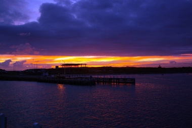
Digital photographs, L.J. Gervasoni, Harbour Pavilion under construction, c2010
warrnambool, coast, coastal, beach, seascape, harbour pavilion, construction, sunset, viaduct road, breakwater -
 Flagstaff Hill Maritime Museum and Village
Document - Plan, Victorian Harbours Warrnambool, Victorian Harbours, Warrnambool, Plan to Accompany Sir John Coode's Report, 28-02-1879
This plan is of great significance to the local history of Warrnambool, in particular the Breakwater and its impact on Warrnambool's maritime and trade history. The plan shows the existing jetties at the Port of Warrnambool, plus the partially erected Breakwater and proposed works to the Breakwater by both the Borough of Warrnambool Surveyor and Sir John Coode. The plan was signed 28th February 1879 by Sir John Coode. The legend at the bottom left describes the existing works and the proposed works. The Warrnambool Breakwater Sir John Coode was a British harbour engineer. He was brought to Melbourne by the Melbourne Harbour Trust to advise on works to improve the Port of Melbourne. The Victorian Government commissioned him to present a plan to complete the Warrnambool Breakwater. His original plan was too expensive so he prepared a revised plan for a shorter structure. The work was completed in 1890. The construction proved to be too short to protect adequately from the weather and didn't allow enough depth for larger vessels to come into port. The decreasing trade was further affected by siltation in the bay due to the breakwater, and the completion of the railway line. The situation of the harbour became a real problem that, by 1910, required continuous dredging. In 1914 the Breakwater was extended but proved to be a failure because the work began to subside and by 1920 about two thirds of the harbour was silted up. Alterations made in the 1920's increased the silting problem and by the 1940's the harbour was no longer used. More alterations were made in the 1950's and 1960's. The Warrnambool Breakwater is registered as a place of significance on the Victorian Heritage Database. This plan of the proposed works for the existing Warrnambool Breakwater is of great significance to the local history of Warrnambool, in particular the Breakwater and its impact on Warrnambool's maritime and trade history. The Warrnambool Breakwater is registered as a place of significance on the Victorian Heritage Database (VHR H2024). It is historically significant to Victoria as one of the most important maritime engineering projects in Victoria in the late 19th century. The Warrnambool Breakwater is of historical significance as one of the most important maritime engineering projects in Victoria in the late nineteenth century. It is evidence of Victoria's nineteenth century investment in regional port infrastructure and the development of Victorian coastal shipping. It is of significance for its association with the English civil engineer Sir John Coode, the most distinguished harbour engineer of the nineteenth century, who was brought to Victoria to advise on works to improve the Port of Melbourne, but was retained by the Government to advise on improvements to the harbours at Portland, Geelong, Port Fairy, and Lakes Entrance, as well as Warrnambool. His projects for Melbourne, Lakes Entrance and Warrnambool were major engineering projects of the nineteenth century. The breakwater is historically significant as a reminder of Warrnambool's early maritime history as a Western District port, and as one of Victoria's major 'outer ports'. While the Warrnambool Breakwater is a demonstration of the engineering skills of the nineteenth century, it also demonstrates the limitations of knowledge relating to sedimentology at the time and the confidence apparent in a number of nineteenth century plans which assumed that natural forces could be overcome or contained by engineering.Plan of Warrnambool Harbour, Port of Warrnambool, dated 28 Feb 1879. Plan shows existing Breakwater and work proposed by both Warrnambool Borough Surveyor and Sir John Coode. Plan has gold coloured quarter-dowel rods top and bottom and a metal ring at the top. Stamped with title. Signed by Sir John Coode.Stamped "VICTORIAN HARBOURS / WARRNAMBOOL / PLAN / to accompany / SIR JOHN GOODE'S REPORT / DATED 28 FEB 1879" Signature "John Coode"flagstaff hill, warrnambool, maritime museum, shipwreck coast, great ocean road, sir john coode, borough of warrnambool surveyor, plan of warrnambool, victorian harbours, warrnambool harbour, warrnambool breakwater, port of warrnambool, vhd vhr h2024, flagstaff hill maritime museum & village, maritime village, map, chart, plan, lady bay, breakwater, jetty, pier, vhr h2024, proposed works, 1879 -
 Flagstaff Hill Maritime Museum and Village
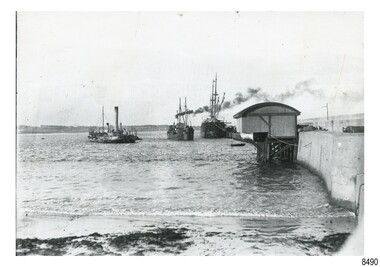
Photograph - Historical, maritime, 1900s to 1930s
This photograph shows the steam dredge Pioneer working to remove silt in Lady Bay, Port of Warrnambool. The dredge belonged to the Ports and Harbours department in Melbourne. Also in the photograph are two moored vessels, and the Warrnambool Lifeboat shed and Rocket house built on the Warrnambool Breakwater. The Warrnambool Harbour had been experiencing heavy silting and sanding for many years. The problem continued even after the construction of the Breakwater in 1890. The Ports and Harbours' new, larger suction hopper dredge, the Matthew Flinders, was also employed in May 1919 to remove the heavy silting in the Harbour. Both dredges were sent up from Melbourne when required over the years to periodically attend to the silting. The Matthew Flinders was still dredging the Harbour even in the 1930s. (The ship’s original master was J G Rosney. In February 1922 Percy Taylor from Ports and Harbours joined the Matthew Flinders as a Mate. 1923 the master in charge was Captain Dunbar. In August 1926 Percy Taylor was appointed as her Master and was later transferred to the Pioneer as Master in 1933.) 1930 the dredges were no longer required as the Harbour was no longer suitable as a port. However, one source notes that the Matthew Flinders was still dredging the Harbour in 1938.This photograph is significant for its association with the Port of Warrnambool, the Warrnambool Breakwater, and the issue of the silting in Lady Bay. The photograph is significant historically as it shows a point in time when efforts were employed to keep the Port of Warrnambool functioning, allowing shipping activities to continue operating. The need for dredging in the Warrnambool Harbour was a serious and ongoing problem, as silting continued to happen after a series of measures were taken to try and resolve the issue. Eventually, the Harbour could no longer function successfully as a port.Photograph, black and white, showing two similar images and printed together. Images of Lady Bay, Warrnambool, the dredge 'Pioneer' on the left, ships and the Warrnambool Lifeboat and Rocket House on the right, beside the Breakwater. Ca. 1900 to 1930."BL016"flagstaff hill, warrnambool, maritime village, maritime museum, flagstaff hill maritime museum & village, dredge, mathew flinders i, warrnambool harbour, lady bay, sanding, silting, breakwater, captain dunbar, ports & harbours, marine technology, percy taylor, matthew flinders, pioneer, dredge pioneer, lifeboat house, rocket house -
 Flagstaff Hill Maritime Museum and Village
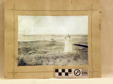
Photograph - Historical, maritime, Brookes' Photographic Union, Warrnambool Harbour (from the battery), 1895
... of the construction of the Warrnambool Breakwater, a construction that changed ...This photograph shows the Lower Light at Flagstaff Hill, Warrnambool, in 1895, part of the Lady Bay Lighthouse Complex. The photograph is part of the Western Victoria collection produced in 1891 by Brookes' Photographic Union in Victoria. Brookes' Photographic Union was a collaboration of two brothers, Frederick Augustus Brookes and his brother Albert Edward Brookes. Frederick arrived in Victoria in the early 1880's. He and Albert formed the organisation to produce collections of photographs including the districts of Geelong, Gippsland and the Western Victoria. This photograph was taken and published just after the construction of the Warrnambool Breakwater. The image records a snapshot of the construction of the Warrnambool Breakwater, a construction that changed the history of the Port of Warrnambool, It is also a record of the Flagstaff Hill area and at that time.Photograph, sepia coloured rectangular shape, mounted between two sheets of cream card. Border of photograph is decorated with pen lines and design in corners. Subject is the Warrnambool Harbour, with a lighthouse on a hill in the foreground, a light coloured picket fence, the harbour with a moored vessel and a jetty. Produced by the Brookes' Photographic Union, and with the heading of Western Victoria. Inscriptions are on the reverse, on two stickers, a printed white label and a handwritten name.Stickers: "F.PA 60/2-74" "138" Label: "WESTERN VICTORIA / BROOKES' PHOTOGRAPHIC UNION / WARRNAMBOOL HARBOUR / (FROM THE BATTERY) Hand written in black: "B. Fisher"flagstaff hill, flagstaff hill maritime museum and village, warrnambool, maritime museum, maritime village, great ocean road, shipwreck coast, western district, western victoria, brookes' photographic union, frederick brookes, albert brookes, photograph, warrnambool harbour, warrnambool history, lady bay, port of warrnambool, b. fisher, 1895, maritime history, breakwater, warrnambool jetty -
 Flagstaff Hill Maritime Museum and Village
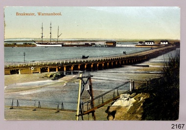
Postcard - Historical, maritime, Breakwater, Warrnambool, ca. 1890
The local photograph shows the original footbridge across the Merri River near its mouth, the Viaduct road and the Warrnambool Breakwater with the Titan crane on it. The breakwater's construction was completed in 1890, the year this photograph was taken. The Viaduct has since been filled in to prevent water from passing through the pylons, and the footbridge has been replaced. The postcard has a personal message written on the back to a Dr Scott from May. The photograph is locally significant for recording the completion of the Warrnambool Breakwater, for showing the original design of the Viaduct and for a clear view of the original footbridge across the Merri River. It is also of significance for being used by a female to send a greeting from Warrnambool to a doctor. Postcard, coloured, of the Warrnambool Breakwater, with the Merri River footbridge and the Viaduct in the foreground. Pedestrians and a horse-drawn cart are on the Viaduct, The lifeboat house and other buildings are near the beginning of the Breakwater. A three-masted sailing ship is in port. The photograph was taken from Middle Island. A personal message is written on the back, and a title is printed on the front. Produced in Germany in the 1890s.On the front: "Breakwater, Warrnambool" Written on the reverse: "Warrnambool Wishing Dear Dr Scott the Compliments of the Season With love and best wishes, From May"warrnambool, shipwreck coast, flagstaff hill, flagstaff hill maritime museum, flagstaff hill maritime village, postcard, coloured postcard, warrnambool breakwater, breakwater, viaduct, 1890s, merri river footbridge, dr scott, may