Showing 120 items
matching water feature
-
 Healesville Sanctuary Heritage Centre
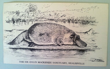
Postcard - Postcard - black and white drawing of platypus
Original postcard featuring black and white pen and ink sketch of a platypus. Landscape in background; water in foreground. Name of artist in right hand lower corner of card. Also Sanctuary identification printed on front and reverse of card.THE SIR COLIN MACKENZIE SANCTUARY, HEALESVILLE A. JORDAN/FROM A PHOTOGRAPHplatypus, sir-colin-mackenzie, healesville-sanctuary -
 National Vietnam Veterans Museum (NVVM)
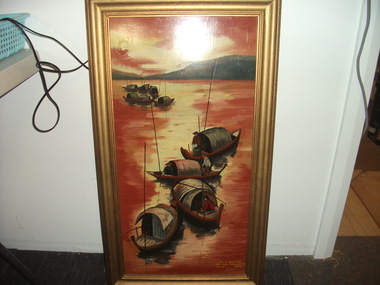
Painting - Painting, Vietnamese scene
See inscription. Gift from Vietnamese Captain to an Australian Captain in 1968Orange, yellow and red colourful Painting. Water scene with ten sampans featured floating: four in foreground and six gathered together in background. Mountain range in background. Three people featured on three sampans. Painting done on board. Wooden frame.Bottom RHS of painting front: "To Capt Goodchild/ From Capt Trung & 10 M.I.D/ June 1968 Vietnam" On frame at back: 5538383 Major Bernard Goodchild 15.01.34 - 01.08.2021, Enlistment date 1965 Discharge 1990, Corps RAAMC, 1st Australian Special Service Civil Affairs Unit, Vietnam (southern zone) 21.06.1967 - 25.06.1968painting, vietnam, goodchild, trung, sampan -
 Tatura Irrigation & Wartime Camps Museum
Photograph, Big Eildon Project, 1954
Taken by photographer for State Rivers and Water Supply Commission.Large sepia photograph. Terraced earthen bank forming wall of reservoir main feature - trees and several telegraph poles in foreground - gently rounded hills on horizon.Below photo: "BIG EILDON PROJECT / MAIN BANK FROM OBSERVATION POINT."victoria state rivers and water supply commission, eildon, eildon dam -
Tatura Irrigation & Wartime Camps Museum
Photograph, Eildon, 1957
Taken by photographer for State Rivers and Water Supply Commission.Large sepia photograph. Featuring huge earthen dam wall middle-right of photo - water in reservoir held back by wall left of middle - hills beyond forming horizon - utility buildings foregroundvictoria state rivers and water supply commission, eildon, eildon reservoir -
 Robin Boyd Foundation
Slide, Robin Boyd, 1966
Robin Boyd was appointed Exhibits Architect for the Australian Pavilion at Expo ‘67 in Montreal. In 1966 Boyd travelled to Far North Queensland and the Northern Territory for research – the Expo exhibits included a coral display, a large rock feature made from Australian sandstone and a native plant garden.Colour slide in a mount. Rocks and water, unknown location, probably Northern Territory, Australia, when visiting Alice SpringsMade in Australia / 28 / DEC 66M4 / Encircled 36A (Handwritten)australia, slide, robin boyd -
 Hume City Civic Collection
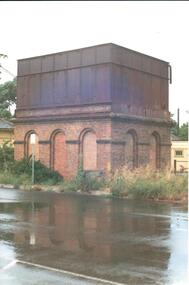
Photograph, 1990-1999
The photograph is one of a series of 6 which feature the Sunbury Railway Station complex. The complex includes photographs of the railway station with the wooden pedestrian bridge which has been demolished and two photographs of the water towers. The photographs were taken before the railway land on the west side of the line was developed to make way for a supermarket complex in 2000.A view of the brick and iron water tower which is sited on the Bendigo side of the Sunbury Railway Station. The brick structure at the base has 3 arched recesses across the front and two at the side. Two of the railway buildings are visible on either side of the tower.sunbury railway station, water towers, footbridges, bridges, railways, george evans collection -
Creswick Campus Historical Collection - University of Melbourne
Photograph - Photographs of VSF students from the play "Gold of Creswick's Creek", Gold of Creswick's Creek, 1952
Two black and White photographs featuring VSF students who played the 'Miners' in the Creswick Centenary Committee production of "Gold of Creswick's Creek". Eric Bachelard, John Opie, Phil Garth, Robert Orr, Stuart Murray, David Anderson, Leo Teller, Ross May.Photographs -
Creswick Campus Historical Collection - University of Melbourne
Still Image, K.J. Simpfendorfer, 1964
About 290 slides of New Zealand study tour featuring logging, agricultural operations, tree species. With full index in Hanimex green metal slide cabinetPhotographic slidesK.J.Simpendorfer Forestry. Study tour of New Zealand -
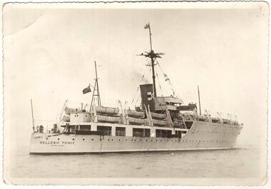 Sunshine and District Historical Society Incorporated
Photograph (1950), The Migrant Ship HELLENIC PRINCE, Copy 27/01/2014 - (Original Post Card circa 1950)
In 1949 the HELLENIC PRINCE with its 3 hospitals, 2 cinemas, and air conditioned accommodation was chartered by the International Refugee Organisation to transport displaced persons from Europe to Australia. Its first trip was to Sydney where it arrived with 1000 passengers on 5 December 1949. On the third trip it left Naples on 23 March 1950, and arrived in Fremantle on 20 April 1950, and in Melbourne on 25 April 1950. The men and women were separated for the voyage with my father sleeping on a hammock in a large room with other men, while my mother, my brother, and I had bunks in a shared cabin. On board were displaced persons ex Bagnoli Camp Italy, some of whom later built their bungalows on the grassy and rocky paddocks near Sunshine Victoria, and began to establish a new life in a new country. A few of the families that arrived on the third trip and purchased land in the Dunkeld Ave - Sandford Ave area of North Sunshine (Birmingham Estate) were Janczak, Kolanowicz, Mroz, Pawlak, Rasztabiga, Skrobalak, Szydlowski, Witkowski, and Zielinski. Some friends settled elsewhere in Sunshine. The family Tabaka went to West Sunshine just over the Derby Rd Bridge, while the family Wojcik went to Ardeer. The ship first started service in 1929 for the Royal Australian Navy as the HMAS ALBATROSS. It had a standard displacement of 4,800 tons and was 443 feet 7 inches (135.2 metres) long, and its top speed during trials reached 22 knots (41 km/hr). It was built at Cockatoo Island Dockyard as Australia's first Aircraft Carrier (seaplanes), but the aircraft that it was designed for were retired just before the ship went into service. A new plane specifically designed to work with the Albatross began operations after the ship was decommissioned in 1933, and placed into reserve in Sydney Harbour. Seaplanes continued to operate from the anchored ship. (Click on the Link 'HMAS Albatross (1)' situated above the Object Registration number to view pictures of the HMAS Albatross on the Navy web site). In 1938 the ship was recommissioned and transferred to the Royal Navy as part payment for the light cruiser Hobart. The ship then did military service for the Royal Navy during World War 2. It did patrol and escort duties in the southern Atlantic, and from mid 1942 in the Indian Ocean. By early 1944 the ship was converted so that it could repair landing craft and other support vessels off Sword and Juno beaches. The ship managed to return 132 craft into service and to save 79 others from total loss. On 11 August 1944 Albatross was torpedoed with the loss of either 50 or 66 personnel, but was able to be towed back to Portsmouth. After repairs she did a short service as a minesweeper depot ship, and following that was placed into reserve on 3 August 1945. In August 1946 the ship was sold for commercial use but the plans to convert it into a luxury liner or a floating cabaret fell through. The ship was again sold on 14 November 1948 to the British-Greek Yannoulatos Group, who renamed it HELLENIC PRINCE in recognition of the birth of Prince Charles and his Greek heritage. After conversion into a passenger ship the Hellenic Prince made several trips to Australia transporting displaced persons, however apparently not all trips were pleasant for the passengers. In the on board newsletter 'Kangaroo' dated 5 January 1951, the ship's master P. C. King expressed his indignation about the behaviour of passengers and made accusations of mutiny. According to some immigrants the conditions were appalling and overcrowded with 1200 passengers. Passengers were supposedly required to work and were paid with Woodbine cigarettes. The drinking water ran out, the freezer broke down, and fresh food that was brought on board went to the crew. Sea sickness was rife because the ship was rarely level due to malfunctioning pumps. (The newsletter 'Kangaroo' can be viewed at the Museum Victoria web site by clicking the Link 'Newsletter - Kangaroo'). In 1953 during the Mau Mau uprising the Hellenic Prince was used to transport troops to Kenya, and in 1954 the ship came to an end in a scrap yard at Hong Kong. THE ABOVE INFORMATION WAS COMPILED FROM; (1) http://en.wikipedia.org/wiki/HMAS_Albatross_(1928) (accessed 11/2/2013), (2) An article by Graeme Andrews found at http://www.afloat.com.au/afloat-magazine/2011/july-2011/The_boat_people_of_the _forties_and_fifties#.UuYY6ou4apo (accessed 27/1/14), (3) http://museumvictoria.com.au/collections/items/273166/newsletter-kangaroo-hellenic-prince-5-jan-1951 (accessed 27/1/14), (4) National Archive search starting at; www.naa.gov.au/collection/search/index.aspx (accessed 27/1/14), (5) http://www.flickr.com/photos/41311545@N05/3864781978 (accessed 29/1/14). Hellenic Prince has a significance to Sunshine Victoria because some of the displaced people from Europe, who arrived in Melbourne on Anzac Day 1950, were among the first people to settle in the grassy and rocky paddock areas of North Sunshine. These settlers established a residential suburban area out of the paddocks. In those early days there were no services and the planned roads were basically just drawings on a map. The ship is also significant because it was named in recognition of the birth of Prince Charles. In the ship's former life as the HMAS Albatross the significance is that it was built in Australia as our country's first Aircraft Carrier (seaplanes).New photograph made from a scanned copy of a circa 1950 Post Card featuring the ship on calm water.Hellenic Prince / Hong Konghellenic prince, migrant ship, displaced persons, refugees, international refugee organisation, bagnoli camp, hmas albatross, yannoulatos group -
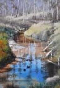 Nillumbik Shire Council
Painting: Walter MAGILTON, Walter Magilton, Sunlight and Shadows, Warrandyte, 2011
Walter Magilton's professional painting career is highlighted by numerous solo exhibitions, five of which have been in Great Britain. He has also won countless prizes, which include many 'Best in Show' awards. Walter is represented in a great number of private and corporate national and international collections, including ART Bank, in approximately twelve countries.This painting is a one of a series of approximately eight works of the river at Warrandyte and the local creeks, with particular emphasis on the reflections in the water and of the wattle growing along the banks. I was particularly inspired by Penleigh Boyde who did similar work while living in Warrandyte in the early 1920s.'Sunlight and Shadows, Warrandyte' is an oil on canvas painting depicting the Warrandyte landscape, featuring a winding creek with beautiful reflections cast upon it. The colour palate comprises muted green and earth tones, with a vivid aqua for reflective water.walter magilton, nillumbik, warrandyte -
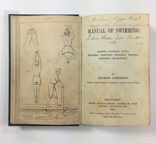 Westbourne Grammar Heritage Collection
Book - Charles Steedman, 1867, Manual of Swimming
Charles Steedman was headmaster of Williamstown Grammar School from 1870-76 and 1885-90. In 1870, under agreement with school trustees, Sir George Verdon and John Courtis, he leased the school under a seven-year lease, effectively saving it from closure. Steedman had previously been manager of Sandridge Baths and a champion swimmer of Victoria. His 1867 book, 'Manual of Swimming', was the first major technical contribution to the sport of speed swimming and water safety, for which Steedman was inducted into the Sport Australia Hall of Fame in 2006. As headmaster of Williamstown Grammar, Steedman initiated a student produced school paper called 'The Schoolboy' (surviving editions can be accessed at the State Library of Victoria), added swimming lessons to the curriculum and opened enrolment to girls in 1885. The book contains nine illustration plates featuring line drawings of a human figure in the positions detailed by Steedman in his text. These drawings are attributed to O.R. Campbell. Oswald Rose Campbell is best known for his appointment (1876-1886) as drawing master of the School of Design, a department of the Public Library, Museums and National Gallery of Victoria. He taught (and famously disagreed with) the likes of celebrated Australian artists, Tom Roberts and Frederick McCubbin. O.R Campbell taught drawing and painting at Williamstown Grammar in the early 1870s.The book holds historic significance for Westbourne Grammar School, having been written by a former headmaster and very important figure in the history of the school. It evokes our early history as an emerging grammar school with links to prominent athletes, artists and gentry of colonial Melbourne. Blue cloth covered case-bound book, with debossed decorative scrollwork in each corner and in the centre of front cover, and gilt lettering on the spine. 270 numbered pages, nine illustration plates (one adjacent to title page, eight as end pages).On title page, handwritten inscriptions in brown coloured ink. Possibly ‘Joshua Saggs Esq. / With the authors compliments’ and below, in different handwriting and darker ink, ‘To dear Flossie from Grandma 1901’. williamstown, sandridge baths, swimming, colonial melbourne, art, williamstown grammar -
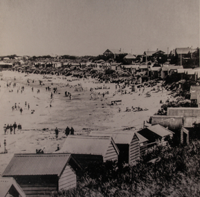 Torquay and District Historical Society
Photograph (copy), Early Torquay Beach Scenes
Photograph shows crowds of beachgoers on Torquay front beach in front of bathing boxes.The bathing boxes in the background were a feature of the Torquay foreshore until 1953. A water tower, long removed, is also visible in the background.Black and white photographtorquay victoria., bathing boxes, beach crowds early 1900s, beach wear -
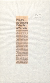 Whitehorse Historical Society Inc.
Newspaper - Article, Plan for Dandenong Valley park under way, 1/06/1992
Development of park along Dandenong Creek from Knox and Nunawading to Rowville and Mulgrave featuring wetlands, billabongs, cycling and walking tracks, bushland, picnic facilities and wildlife.dandenong creek, melbourne water, floyd, jeff, dandenong valley metropolitan park, chesterfield, chris, parks and reserves -
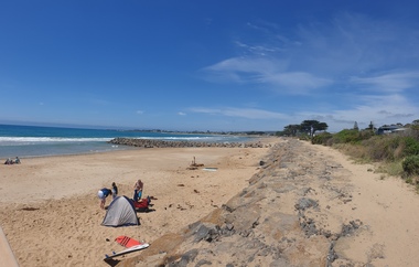
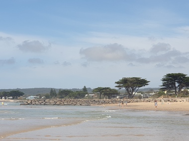 Ballarat Heritage Services
Photograph, Clare Gervasoni, Apollo Bay, Victoria, 24/01/2022
In 2021, the Department of Environment, Land, Water and Planning (DELWP) constructed two new groynes and a section of rock seawall at Apollo Bay to help manage the impacts of coastal erosion. The new 70-meter-long rock groynes run perpendicular to the shoreline and be located just south of the Milford St revetment and to the south of Milford Creek. Sections of rock seawall will be constructed between the two Groynes with an aim to protect the dune, walking path, cypress trees and road from erosion. Colour photograph of a coastal scene at Apollo Bay, featuring new rock groynes to protect the Great Ocean Road from erosion. apollo bay, beach, coast, groyne, rockwall -
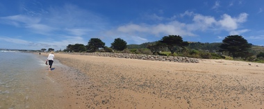 Ballarat Heritage Services
Photograph, Clare Gervasoni, Apollo Bay, Victoria, 24/01/2022
In 2021, the Department of Environment, Land, Water and Planning (DELWP) constructed two new groynes and a section of rock seawall at Apollo Bay to help manage the impacts of coastal erosion. The new 70-meter-long rock groynes run perpendicular to the shoreline and be located just south of the Milford St revetment and to the south of Milford Creek. Sections of rock seawall will be constructed between the two Groynes with an aim to protect the dune, walking path, cypress trees and road from erosion. Colour photograph of a coastal scene at Apollo Bay, featuring new rock wall and groynes to protect the Great Ocean Road from erosion. apollo bay, beach, coast, groyne, rockwall -
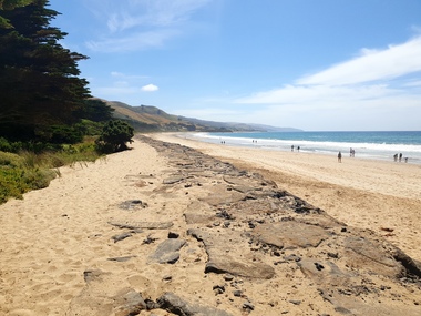 Ballarat Heritage Services
Photograph, Clare Gervasoni, Sea Wall at Apollo Bay, Victoria, 24/01/2022
In 2021, the Department of Environment, Land, Water and Planning (DELWP) constructed two new groynes and a section of rock seawall at Apollo Bay to help manage the impacts of coastal erosion. The new 70-meter-long rock groynes run perpendicular to the shoreline and be located just south of the Milford St revetment and to the south of Milford Creek. Sections of rock seawall will be constructed between the two Groynes with an aim to protect the dune, walking path, cypress trees and road from erosion. Colour photograph of a coastal scene at Apollo Bay, featuring new rock wall and groynes to protect the Great Ocean Road from erosion. apollo bay, beach, coast, groyne, rockwall, sea wall -
 Ballarat Heritage Services
Photograph - Colour, Clare Gervasoni, Entrance to Vaughan Springs, 2017, 16/07/2017
... cemetery chinese mineral water Timber entrance feature to Vaughan ...Timber entrance feature to Vaughan Mineral Springs Reserve.vaughan, vaughan springs, vaughan chinese cemetery, chinese, mineral water -
 Ballarat Heritage Services
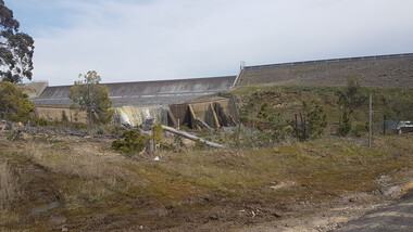
Photograph - Digital photograph, Lisa Gervasoni, Upper Coliban Reservoir, 2017
Constructed in 1903 and enlarged in 1917 this dam originally featured the only siphonic spillway in Victoria. Being the uppermost of the three Coliban storages, it is usually the first drawn down in periods of high demand.Colour photograph of the Upper Coliban Reservoir.upper coliban, coliban, water, reservoir, supply, system, upper coliban reservoir, water storage -
 Ballarat Heritage Services
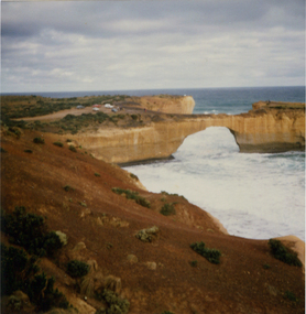
Photograph, London Bridge, Great Ocean Road, 01/1990
London Bridge, pre 1990 was a double-spanning bridge connected to the mainland. The stack was created over hundreds of years, with the weaker layers toward the base being eroded away by wind and water to form the two bridges. The span closer to the shoreline collapsed unexpectedly on 15 January 1990, leaving two visitors, whilst uninjured, stranded on the outer span before being rescued by helicopter. Two coloured photographs of the London Bridge, on the Great Ocean Road. This photo was taken days before the collapse of the geological feature. The photographer walked across the bridge to the warning of her mother "if you go over there and it collapses you will be stuck. After the collapse it was renamed London Arch. london bridge, great ocean road, london bridge, peterborough, london arch, shipwreck coast, 12 apostles -
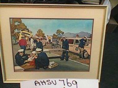 Ambulance Victoria Museum
Painting, Car Accident Scene
As St John ambulances are featured in this 1960s accident depiction, the event shown has occurred in either South or Western Australia.Water colour painting. Depicts car accident victim being treated on the road by ambulance officers. Two St John ambulances in scene and police officer (motor cycle branch). Full colour painting. -
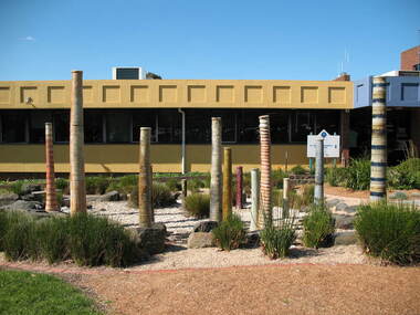 South Gippsland Shire Council
Sculpture, Water Sculpture, 1999
Ceramic outdoor sculpture featuring 15 clay pipe forms of various heights and designs. Decorated with a range of diferent designs and paint slips. Water pumped through each pipe to make a waterfeature in the council garden. -
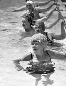 Melbourne Legacy
Photograph - Exercise Classes, Swimming classes
From 1928 until the 1980s, Melbourne Legacy ran an excellent exercise program for its widows. Classes were held weekly at Legacy House and there was often a waiting list for the water classes, which had both swimming instruction and water exercises. Some of the class members were in their 90s, many just learning to swim. A record of activities provided for Legacy widows.Black and white photo of six older women in a swimming pool, holding onto a bar at the edge of the pool.Stamped on the back: "COPYRIGHT / HERALD - SUN / PHOTOGRAPH / SUPPLIED BY / FEATURE SERVICE / THE HERALD & WEEKLY TIMES LTD. / MELBOURNE AUSTRALIA" Written on the back and circled in blue pen: "2"widows, exercise classes, swimming, activities -
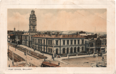 Ballarat Tramway Museum
Postcard, J Ewins, "Post Office, Ballarat", 1911
View of the intersection of Sturt St and Lydiard St Nth with the Ballarat Post Office being the primary feature. Has an ESCo tram turning from Sturt St into Lydiard St. Shows the trackwork at this location and has several horse-drawn vehicles in the photograph. Would appear that Lydiard St north has either been watered or is being repaired. On the rear is a message to friends of a lady keeping house on a farm (Coolaban) near Lubeck Vic. It is dated 29/10/1911.Demonstrates postcard printing c1910 and has a strong association with the sender.Postcard - coloured, divided back, published by J. Ewins of Ballarat and printed in England.See image 2 for the letter sent in 1911.tramways, trams, esco, post office, lydiard st nth, sturt st -
Queenscliffe Maritime Museum
Machine - Outboard Motor
Featured variable pitch propeller for reverse, exposed gear driven magneto, steering via a rudder.Single cylinder water cooled 2 stroke Waterboy outboard motor. outboard motor, waterboy -
 Bendigo Historical Society Inc.
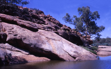
Slide - Dunn's Rock Eppalock, 2012
The low rolling hills of the Kimbolton countryside consist of ancient, hard and fractured Ordovician rock up to 65 million years old, which was originally deposited deep under the sea. Rocks mainly are sandstone, mudstone, black shale and quartz conglomerates. Marine fossils can be found in the area. Around seven million years ago a basalt flow buried the original bedrock along the along the Campaspe River. Ongoing weathering, wind and water movement over the following years has produced younger clay, sand, silt and gravel deposits throughout the area. Patches of White Hills Gravel are also found in the area. Another unique geological feature of this area is the Permian Glacial Pavement rocks north and south of Eppalock and glacial sediments (such as “Dunn’s Rock” and “Kellams Rock”). During the ice age (up to 280 million years ago) large glaciers moving over the countryside, scoured out sediments, pulverized bedrock, polished and cut grooves into bedrock in the direction of ice movement. When the ice melted boulders etc where left behind in areas of entirely different rock types, such as a 100 Tonne granite block known as ‘The Stranger’ near Derrinal. Dunn's Rock (Glaciated Pavement) Eppalock - Photos of the rock and a field group collecting date with Lake Eppalock (Knowsley) in the backgroundhistory, bendigo, dunn's rock eppalock, kimbolton forest, lake eppalock, gately collection -
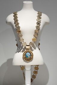 Bayside Gallery - Bayside City Council Art & Heritage Collection
Ceremonial object - Mayoral chain, Lega, City of Brighton Mayoral Chain, 1953
This chain was part of the official regalia worn by the Mayor of the City of Brighton before the amalgamation into Bayside City Council in 1994. The chain was seen as an outward sign of power, authority, and responsibility and was a formal, full-dress type of regalia that was worn by the mayor over their robes at ceremonial functions. The large central drop medallion featured the design of the council seal and the links of the chains detail the name and date of each appointed Mayor. This council seal features the Brighton coastline with a pier extending to the water, a sail boat in the distance and a train on the right of the pier. It was displayed by Council on its flag and letterhead and in municipal buildings and can still be seen on the portico of Brighton Town Hall. The seal was used from 1919, when Brighton was declared a city, until 1970, when an official crest was issued by the British College of Heraldry. Brighton was first incorporated as a borough on 18 January 1859, it became a town on 18 March 1887 and was proclaimed a city on 12 March 1919.9 carat yellow gold and enamel mayoral chain for the City of Brighton. Consists of 61 small oval links, with a scroll listing significant dates in Brighton's history as a centrepiece and a large 'drop' medallion of the City of Brighton seal below. Each oval link has a central plaque inscribed with a mayor's name and dates of their office surrounded by a thin coiled edge and a thick decorative border. The earliest Mayor is W.P. Francis 1918-19 and the latest is K.D. Oliver 1994-95. The links are joined by cable chain and form a long circular chain with two crosspieces of additional links at the back, the upper crosspiece contains four links, while the lower piece contains three links. The chain has a large oval medallion/pendant of the City of Brighton seal which is surrounded by a thin coiled gold edge, a border containing raised lettering 'CITY OF BRIGHTON' above and a Coat of Arms below. This is also surrounded by a coiled edge. The oval piece is then wrapped around with a thick laurel wreath with small berries. The central part of the medallion contains a coloured enamel image of the Brighton coastline with sand in the foreground, a pier extending out into the water, a sailboat in the distance and a train on the right of the pier. The small Royal Coat of Arms of the United Kingdom below includes a coloured enamel shield flanked by a lion and unicorn with a motto inscribed on a ribbon underneath 'DIEU ET MON DROIT'.mayoral chain, city of brighton, lega, ceremonial wear, seal, medallion, mayor, coat of arms, crest, bayside, mayoral regalia -
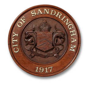 Bayside Gallery - Bayside City Council Art & Heritage Collection
Plaque, City of Sandringham plaque
The Sandringham seal, which was designed by Sans and McDougall, had been selected in 1917 by a special committee and depicted as its main feature the Sandringham pier and breakwater, with a yacht in full sail, as an inset, and supported by two dolphins. The motto selected was Omni Opere ("With all earnestness.")Carved wood, with metal cast lettering. Carved relief City of Sandringham seal in the centre of the plaque with lettering 'CITY OF SANDRINGAM 1917' cast in metal around the border. On the central shield is the depiction of a large sailboat in the water at the top, below it an L-shaped pier protruding from the right and below that another pier protruding from the left with two small boats at the bottom. The shield is flanked by two dolphins, with St Edward's crown above, and a banner containing the motto 'OMNI OPERE' beneath. The area around the seal is decorated with a carved circular pattern.plaque, city of sandringham, sandringham coat of arms, seal, omni opere, bayside, coat of arms, crown, crest -
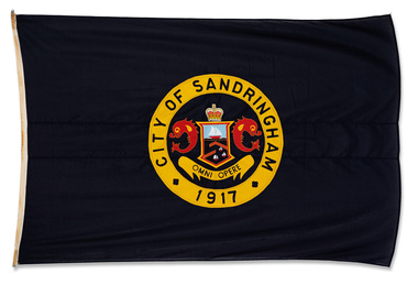 Bayside Gallery - Bayside City Council Art & Heritage Collection
Flag, Gairs, City of Sandringham flag
The Flag contains the Sandringham seal, which was designed by Sans and McDougall, had been selected in 1917 by a special committee and depicted as its main feature the Sandringham pier and breakwater, with a yacht in full sail, as an inset, and supported by two dolphins. The motto selected was Omni Opere ("With all earnestness.").Dark blue flag with circular City of Sandringham seal in the centre with the words CITY OF SANDRINGHAM in yellow border around the outside. The seal contains a central shield depicting a large sailboat in the water at the top, below it an L-shaped pier protruding from the right and below that another pier protruding from the left with two small boats at the bottom. The shield is flanked by two dolphins, with St Edward's crown above, and a banner containing the motto 'OMNI OPERE' beneath. flag, city of sandringham, seal, crest, omni opere, pier, boat, motto, sans and mcdougall, with all earnestness, st edward's crown -
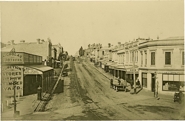 Kew Historical Society Inc
Photograph, J F C Farquhar, High Street, Kew, 1891
At the beginning of the 1890s, the Kew businessman and Town Councillor, Henry Kellett, commissioned J.F.C. Farquhar to photograph scenes of Kew. These scenes included panoramas as well as pastoral scenes. The resulting set of twelve photographs was assembled in an album, Kew Where We Live, from which customers could select images for purchase.The preamble to the album describes that the photographs used the ‘argentic bromide’ process, now more commonly known as the gelatine silver process. This form of dry plate photography allowed for the negatives to be kept for weeks before processing, hence its value in landscape photography. The resulting images were considered to be finely grained and everlasting. Evidence of the success of Henry Kellett’s venture can be seen today, in that some of the photographs are held in national collections.It is believed that the Kew Historical Society’s copy of the Kellett album is unique and that the photographs in the book were the first copies taken from the original plates. It is the first and most important series of images produced about Kew. The individual images have proved essential in identifying buildings and places of heritage value in the district.In 1891, High Street was the centre of commercial activity in the Borough of Kew. It was unpaved and edged with deep bluestone gutters, which were designed to channel the significant flow of storm water down the hill to and beyond the Junction. On either side of the entrance to the shopping strip are two cast iron gas lamps that provided the only public street lighting before the Post Office was reached. Most shops, including the Nicholas Brothers’ Junction Store featured cast iron verandas. Further up the hill, Dougherty’s Greyhound Hotel was by this stage a local institution. Apart from the horse-drawn tram, the main form of personal and commercial transport in this period remained the horse, horse and cart, or buggy.The panoramic view predates the widening of High Street in the 20th century, and thus includes the original alignment of buildings on the south side. These included Henry Kellett’s shop.High Street, Kewkew illustrated, kew where we live, photographic books, henry kellett, high street - kew (vic)