Showing 13705 items
matching wye-river-bridge
-
 Orbost & District Historical Society
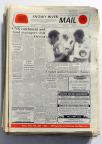
newspapers, Snowy River Mail, 1994
The Snowy River Mail is a weekly newspaper published in Orbost in the Shire of East Gippsland, Victoria, Australia. Previously published as The Snowy River mail and Tambo and Croajingolong gazette from 1890 to 1911. The Gippsland Courier merged with the Snowy River Mail when proprietor Lachlan Ross moved to Orbost in 1910. In 1999 the paper was acquired by the Yeates family when the Hollins family retired from the newspapers business. The paper is still being produced by the fourth generation of the Yeates family as part of East Gippsland Newspapers These newspapers are useful research tools as they contain contemporary accounts of local events.A cardboard box of black/white newspapers. There are 49 issues of the Snowy River Mail from 1994. All contain news reports, articles, photographs and advertisements a catalogue inserts. newspapers snowy-river-mail -
 Ballarat Heritage Services
Painting, Clare Gervasoni, Old Bridge over the Woady Yallock River, 26/03/2023
Colour photographs of an old timber topped bridge crossing the Woady Yalloak River on Golden Lake Road. The bridge has bluestone foundations. bridge, woady yallock river, golden lake road, bluestone -
 Orbost & District Historical Society
newspaper, Snowy River Mail, August 9 1890
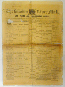
Published as The Snowy River mail and Tambo and Croajingolong gazette from 1890 to 1911. The Gippsland Courier merged with the Snowy River Mail when proprietor Lachlan Ross moved to Orbost in 1910 In 1999 the paper was acquired by the Yeates family when the Hollins family retired from the newspapers business.The paper is still being produced by the fourth generation of the Yeates family as part of East Gippsland Newspapers. They also produce the Bairnsdale Advertiser, the East Gippsland News and the Lakes Post and the yearly publications East Gippsland Visitor Guide and the Great Alpine Road Touring Guide. This newspaper is still being produced today. Local newspapers play a vital role in communities as they are central to communication networks in regional areas of Australia. They are a valuable source of local news, act as a forum for debate and often set the agenda for local discussion. This item is a useful research tool as it reflects contemporary views.This newspaper is a first issue of 4 pp. It is titled "Snowy River Mail & Tambo and Croajingolong Gazette Orbost Saturday August 9 1890".snowy-mail-newspaper first-issue -
 Lakes Entrance Historical Society
Photograph, Caire, Nicholas John, Swing Bridge Sale Victoria, 1905c
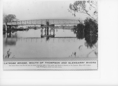
turning on a central axis to allow the passage of river vessels. Image shows machinery for operation and the bridge closed to river traffic. Latrobe Wharf on the left bank is seen through bridge. Sale VictoriaBlack and white photograph of the Latrobe Bridge. This was a swing bridge over the Latrobe Riverbridges, waterways, civil engineering, jetties -
 Orbost & District Historical Society
newspaper, Snowy River Mail, June 14 1978
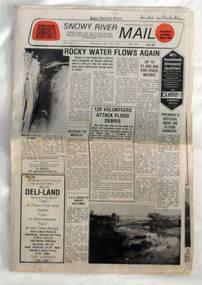
Orbost has been subject to major floods throughout its history, such as those which left the town isolated in 1934, 1952, 1971 and 1978. It is recorded that the Snowy River broke its banks and flooded the flats 104 times between 1884 and 1978. Extensive flooding in Eastern Victoria during June 1978, caused widespread damage to roads, road closures and hazards to traffic, particularly over the Queen's Birthday holiday weekend.Since 1890 the Snowy River Mail has been the local newspaper of the Orbost district.This local paper has been the means by which readers in Orbost were able to learn about newsworthy events and issues in their local community for over a century. This paper is a contemporary record of a significant event in Orbost's history of flooding.A newspaper, Snowy River Mail, which contains black / white photographs of the 1978 floods in Orbost.orbost-floods-1978 -
 Chelsea & District Historical Society Inc
Photograph - Patterson River, Rail and Road Bridge
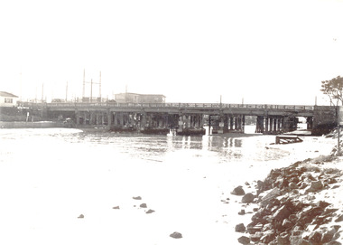
The first bridge over the river was built in the early 1880's, prior to this it was a pontoon bridge.Black and white photo of the road bridge (Point Nepean / Nepean Highway) and rail bridge, near the mouth of the Patterson River. Taken from the mouth of the river.patterson river, road bridge, rail bridge, chelsea, transport, patterson river bridge, carrum bridge -
 Chelsea & District Historical Society Inc
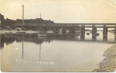
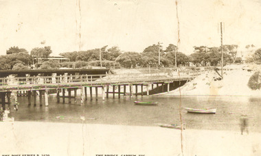
Photograph - Patterson River, Rail and Road Bridge, Carrum
The first bridge over the river was built in the early 1880's, prior to this it was a pontoon bridge. In 1927 a concrete bridge was built to replace the wooden bridge.Black and white photo of Patterson River, looking east from the Port Phillip Bay. PATTERSON RRIVER BRIDGE, CARRUMpatterson river, chelsea, patterson river bridge, carrum bridge, canoes, beach, leisure -
 Lakes Entrance Historical Society
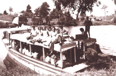
Photograph - Zephyr, Peels launch Zephyr on Tambo River near bridge at Swan Reach Victoria, 1940 c
Black and white photograph of Peels launch Zephyr filled with passengers moored at landing place on Tambo River near bridge at Swan Reach Victoria. Also a second black and white photograph of Peels launch Zephyr in Tambo River with Swan Reach bridge in backgroundboats and boating, tourism, rivers -
 Greensborough Historical Society
Photograph, Plenty River Greensborough, 1910c
It shows the Plenty river in Greensborough in flood and the bluestone bridge at the bottom of the Main Street hill.The bluestone bridge was built in the mid 1860's and was demolished 1970's.A black and white photograph of a bridge over a river in flood.Nilgreensborough, plenty river, floods, bridges, bluestone -
 Lakes Entrance Historical Society
Book, Davidson, Rachael, The Nicholson River Railway Bridge, 2004
Research, interpretation and management recommendations for the Nicholson River Railway Bridge, East Gippsland, Victoria, by a Forestec student.bridges, transport -
Lakes Entrance Historical Society
Book, Van der Heyden Becky, Calulu Mitchell River Bridge, 2004
Research interpretation and management recommendations for the Calulu Mitchell River Bridge, near Bairnsdale, Victoria by a Forestec Studentbridges, waterways, settlers -
 Orbost & District Historical Society
black and white photographs, February 17 1971
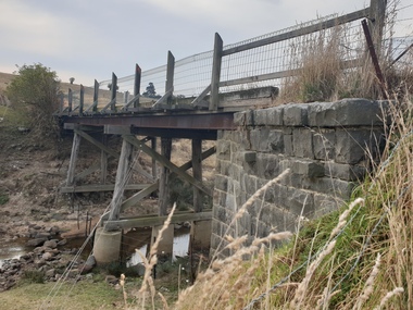
After the damage from the February 1971 floods at Orbost when the abutment to the Snowy River road bridge was washed away a Bailey bridge, portable, pre-fabricated, truss bridge, was put into place to ensure town access, the C.R.B. rebuilt the approach to the bridge driving new piles and constructing the Bailey bridge. They worked late into the night under flood lights to ensure the link from the Orbost township to the Princes Freeway would be open to traffic as soon as possible.These photographs are pictorial records of a significant event in the history of Orbost.Three black / white photographs of a Bailey bridge being erected across a river. 3245.1 and 3245.2 are the same. bailey-bridge orbost-snowy-river-bridge bridge-orbost -
 Orbost & District Historical Society
black and white photographs, November 1976
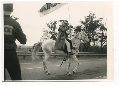
All of these photographs were taken prior to 25th November, 1876, the official opening and crossing of the current Snowy River Bridge. Gary Downey, an Orbost Apeian, did a "De Groot" and crossed the bridge on horseback prior to the official cars crossing the bridge to signal the opening of the new structure. There was a closing ceremony for the old bridge with a group arriving in a 1927 Chrysler, owned by Apexian, Peter Dreverman. This was watched by groups of school students. Some of the Apex members, including Jim Duggan, Noel Smart and Pat Hall, dressed in formal attire to speak to the audience.This event was organised by the Apex Club of Orbost.The Apex Club of Orbost was a volunteer service club which contributed to the Orbost community. A declining population has led to the demise of many social groups in the area.Ten black / white photographs related to the unofficial opening of the Snowy River Bridge at Orbost. snowy-river-bridge-1976 apex-club-orbost ceremony -
 Orbost & District Historical Society
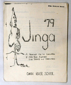
newsletter, Jinga, July 1979
Cann River is 75 km east of Orbost. The Cann River School newsletter is published fortnightly and includes a calendar of upcoming activities in the school and local community. When the newsletter started (probably in 1968) there was a discussion in the school as to what it would be called - Jinga eventually came out of that and it's still the same today. Jinga derived its name from Croajingolong. Croajingolong possibly comes from the Aboriginal words for 'belonging to' and 'east' and is the name of one of the five clans of the Kurnai (Gunni) - the Krauatungalung, who lived in this region. It is likely that the decision to go with 'Jinga' over 'Jingo' was made by popular vote. For a few years the school published a year magazine called Croalong, and now combines the two so the last issue of Jinga for the year is actually titled Croajingolong! (Information provided by Ruby, current editor of Jinga.) In small rural communities newsletters are an important communication medium. Cann River P-12 College has played a significant part in the education students in the Cann River district . It is the sole educational institution in Cann river. A newsletter for Cann River School. It contains black and white photographs, children's work and reports.newsletter-jinga cann-river -
 Lakes Entrance Historical Society
Photograph - Murrindal River Bridge Murrindal Victoria, 1/03/2000 12:00:00 AM
Colour photograph of the timber bridge across the Murrindal River Murrindal Victoria. Also a second colour photograph showing approach to bridge with signs prohibiting cattle droving and use of side track.bridges, forest, civil engineering -
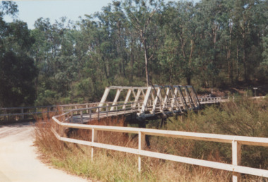
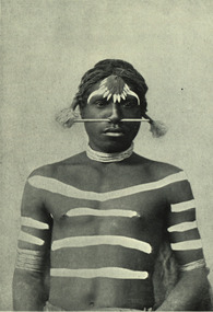 Federation University Historical Collection
Image - black and white, Barwon River Man (New South Wales)
Digitised directly from 'The Native Races of the British Empire: Victoria' The Barwon River in New South Wales is formed through the confluence of the Macintyre River and Weir River (part of the Border Rivers system), north of Mungindi, in the Southern Downs region of Queensland. The Barwon River generally flows south and west, joined by 36 tributaries, including major inflows from the Boomi, Moonie, Gwydir, Mehi, Namoi, Macquarie, Bokhara and Bogan rivers. During major flooding, overflow from the Narran Lakes and the Narran River also flows into the Barwon. The confluence of the Barwon and Culgoa rivers, between Brewarrina and Bourke, marks the start of the Darling River.Black and white Image of an Aboriginal man from Barwon River, New South Wales. Aboriginal people from six language groups originally occupied the area of the Barwon River wetlands. These were the Ngemba, the Baranbinja, the Murrawari, the Ualayai, the Weilwan, and the Kamilaroi peoples. The Aboriginal people generally used the wetlands for hunting, fishing, and gathering uses, and for cultural association.(Wikipedia) The name "barwon" is derived from the Australian Aboriginal words of barwum or bawon, meaning great, wide, awful river of muddy water; and also baawan, a Ngiyambaa name for both the Barwon and Darling rivers. The history, culture and livelihoods of the local Aboriginal people are closely intertwined with the Barwon River and its associated tributaries and downstream flows. (Wikipedia)aborigine, aboriginal, barwon river -
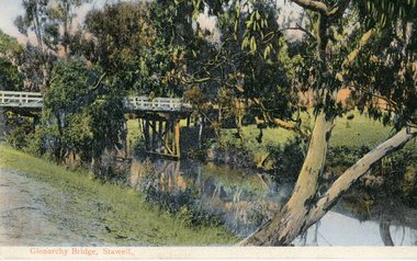 Stawell Historical Society Inc
Postcard, Bridge at Glenorchy -- Postcard -- Coloured
Coloured postcard of Bridge at Glenorchy.Coloured Post card of a timber bridge over a river in bush settings.On Front Glenorchy Bridge, Stawell On Reverse Printed in Germany 155/81467 Post Card This Space May be used for Correspondence. This for Address Only.water -
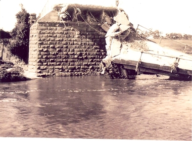 Federation University Historical Collection
Photograph - Photographs, Richard Vincent, Washed Away Bridge at Garibaldi, c1933
Newspaper clipping documents deputations to the Minister of Public Works for grants to be made available for repairs to bridges and roads damaged by heavy flooding in 1933, in particular, the replacement of a stone and concrete bridge over the Leigh River at Garibaldi in the Buninyong Shire. The concrete slabs were still in the water in the 1960s/70s or even later. Three black and white photographs showing flood damage to the bridge over the Leigh River at Garibaldi, plus a photocopy of a newspaper clipping from The Argus December 1933 describing the extent of the flood damage. .1) shows blue stone buttress and collapsed bridge/road. .2) mirror image of above .3) unknown man waling an a girder of the Garibaldi bridge .4) photocopy of newspaper clipping about flood damage from The Argus December 1933Damage by Floods: Bridges washed away (The Argus December 1933)leigh river, garibaldi, buninyong shire, richard vincent, garibaldi bridge -
 Chelsea & District Historical Society Inc
Photograph - Patterson River, Rail and Road Bridge, c 1912
The first bridge over the river was built in the early 1880's, prior to this it was a pontoon bridge.Sepia photo of the road bridge (Point Nepean / Nepean Highway) and rail bridge, near the mouth of the Patterson River., Carrum patterson river, road bridge, rail bridge, chelsea, transport, patterson river bridge, carrum bridge -
 Stawell Historical Society Inc
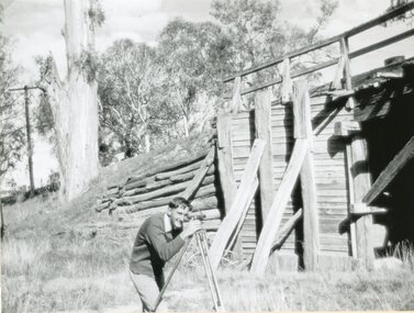
Photograph, Old Wooden Bridge - over the Wimmera River at Joel Joel being surveyed by Allan Rowe for a new bridge 1951
Old Wooden Bridge - Joel Joel (Wimmera River) 1951 being surveyed by Allan Rowe for new bridgestawell shire -
 Orbost & District Historical Society
book, Snowy River Mail as "Mail" Print, Princes Freeway Orbost Section, 2117.1 : 1976 2117.2 : 4.9.2013
The Snowy River Bridge, Princes Freeway, Orbost, Victoria was opened by the Hon. J A Rafferty, Minister for Transport, 25 November 1976. ‘The bridge was built at a cost of A$2.4 million and is the first of four bridges to be built as part of the 8.4 kilometre freeway bypass of Orbost. Construction of the bridges commenced in January 1975, with an expectation to open the bridge across the Snowy River as soon as possible. Less than two years later, on 25 November 1976, the bridge across the Snowy River was opened to traffic, allowing the old bridge to be demolished. The remainder of the Orbost Bypass, both the floodplain crossings and the eastern section around the township itself, was declared ‘Princes Freeway’. The newspaper article was written by David Jellie as part of the centenary celebrations of Vic Roads/Country Roads on 4.9.2013. David Jellie was the project engineer for the Snowy River Crossing Project.This book and article contain historical information and details about the construction of the bridges on the Orbost section of the Princes Freeway.2117.1 isaA thin paperbook book which contains a map, history and construction details of the Princes Freeway at Orbost. It has a program for the opening ceremony of the snowy River Bridge in 1976. 2117.2 is an article from the snowy River Mail on the history of the highway. It is dated 4.9.2013.In pencil - 20csnowy-river-bridge jellie-david princes-freeway-orbost -
 Lorne Historical Society
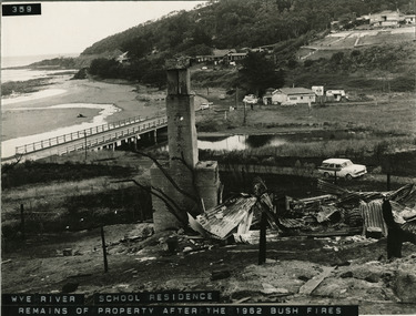
Photograph - Photograph Wye River house after 1962 bushfire, McRae house at Wye River after 1962 bush fires
Remains of the McRae house after the 1962 bush firesmcrae residence, bushfires 1962, wye river -
Lakes Entrance Historical Society
Book, Anderson Christopher, The Snowy River Floodplains Railway Bridge, 2003
Research interpretation and management recommendations for the Snowy river Flood plains railway bridge, near Orbost East Gippsland victoria by Forestec studentbridges, transport, employment -
 Lakes Entrance Historical Society
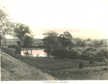
Postcard - Mitchell River Bairnsdale Victoria, 1920 c
One of the series of postcards used in the tourist industryPostcard of scene of Mitchell River with fences in the foreground and in the background bridge and Bairnsdale VictoriaThe Mitchell River Bairnsdalehouses, rivers, topography -
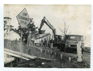 Orbost & District Historical Society
black and white photographs, 1976 - 1977
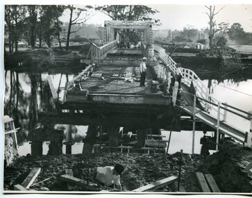
These photographs are of the demolition of the road bridge across the Snowy River at Orbost. This bridge over the Snowy River was opened on July 4 1922. It was constructed in 1922 alongside the previous suspension bridge. Its building was a combined effort of the Victorian Railways and the Country Roads Board at a cost of 35,000 pounds. It was replaced in 1976 by the present bridge after several major floods.This bridge was replaced in 1976 after several major floods. These photographs are pictorial records of its demolition.Four black / white photographs of the demolition of a road bridge across a river. In them can be seen trucks, excavators and workmen. In 3246.1 there is a triangular road sign - "LOW CLEARANCE 3.9m"bridge-demolition orbost-snwoy-river-bridge -
 Chelsea & District Historical Society Inc
Photograph - Patterson River, Rail and Road Bridge, c 1910
The first bridge over the river was built in the early 1880's, prior to this it was a pontoon bridge.Black and white photo of the wooden road bridge (Point Nepean / Nepean Highway), over Patterson River, Carrum near the mouth of the river. patterson river, road bridge, rail bridge, chelsea, transport, patterson river bridge, carrum bridge -
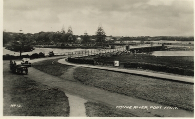 Port Fairy Historical Society Museum and Archives
Postcard, Moyne River, Port Fairy
Postcard made for tourists visiting port FairyBlack and white photograph of the road bridge crossing the river Moyne No 12 - Moyne River, Port Fairymoyne bridge, postcard, botanical gardens, cart, car, river, road, gipps street -
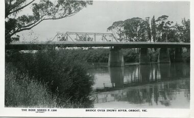 Orbost & District Historical Society
black and white photograph, Rose Stereograph Company, first half 20th century
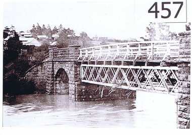
A new bridge over the Snowy River at Orbost was opened for traffic on June 20th 1922. It was a new timber and steel girder structure, a joint Country Roads Board — Victorian Railways venture and was built and completed at a cost of £41,000 (the steel girders came from the Flinders Street viaduct reconstruction). Subsequently it was decided not to take the railway across the river, and the bridge was only ever used by road traffic. Postcards form a vital part of social and historical records for researchers. This postcard is a pictorial record of an earlier bridge across the Snowy River at Orbost.A black / white postcard photograph of a bridge over the Snowy River at Orbost.0n front - The Rose Series P1200 copyright Bridge Over Snowy River Orbost Vic.snowy-river-bridge -
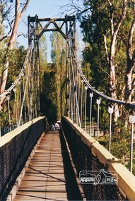 Eltham District Historical Society Inc
Photograph, Pedestrian suspension bridge over the Yarra River at Lower Plenty
Odyssey House drug rehabilitation centre in Bonds Road, Lower Plenty is a distinctive landmark, especially when viewed from across the Yarra at Templestowe. It was built in the 1950’s as a seminary for the Blessed Sacrament Fathers. Because of the poor and circuitous road access, a suspension footbridge was built across the river. As well as providing easy access for the priests residents of Templestowe could attend services at the seminary. The bridge is now part of the Yarra Trails system.Colour photograph of footbridge over Yarra River, part of the Ruffey Trail just off the Main Yarra Trail near the former seminary (now Odyssey House) Lower Plentybridges, yarra river, lower plenty, seminary, blessed sacrament fathers, odyssey house, bonds road -
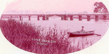 Lakes Entrance Historical Society
Photograph - Bridges, 1900
Opened March 1889, centre lifting span unsuccessful so shipping trade up Nicholson River effectivly terminatedPink toned scanned photograph of the first bridge across the Nicholson River. Shows a timber bridge with centre designed as a drawbridge. Woman in rowing boat in foreground. Nicholson VictoriaNicholson River Bridgebridges, waterways