Showing 10185 items
matching dandenong
-
 Melbourne Tram Museum
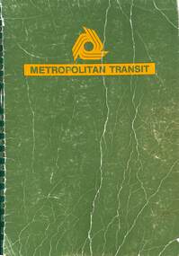
Document - Tender Document, Metropolitan Transit Authority (MTA), "Electric Trams Contract No. 4000", 1984
The specification produced by the Metropolitan Transit Authority (The Met) for manufacturing, supplying, and delivering electric trams. Has three options for delivery - 200 four-axle trams, 100 four-axle and 60 six-axle or 120 six-axle articulated trams. The last was selected. Tenders closed 27/4/1984. The donor used the book to superintend the contract by Comeng Dandenong. Has many notes for future engineering reference. See htd7741doc.pdf for source details.Demonstrates a specification document produced by the MTA for the B2 class trams.Bound specification approx 300 pages, with green cover and green comb binding. Has many loose sheets.Extensive notes throughout document for future issues, and current queries.tramways, tramcars, new tramcars, b2 class, comeng, tenders -
 Melbourne Tram Museum
Document - Notices to Traffic Staff, Melbourne & Metropolitan Tramways Board (MMTB), "Traffic signal lights Nicholson & Gertrude Sts, 1968
Set of three notices glue to one backing sheet: 1 - "Traffic signal lights Nicholson & Gertrude Sts. = C 1297, dated 23/1/1968 2 - Reinstallation of crossover in Dandenong Road , east of Chapel St - C1308, 15/2/1968 3 - Scholar Concession tickets - re use of these tickets on public holidays, and ability to pay a "build up" fare for extension of travel using the Concession ticket - dated 15/2/1968.Yields information about misc. matters of early 1968.Set of 3 notices printed, and glue to a sheet of paper on both sides.tramways, scholar's tickets, traffic lights, gertrude st, nichsolson st, dandenong road -
Southern Sherbrooke Historical Society Inc.
Information folder - Lockwood House
Folder containing items pertaining to the history of Lockwood House, Belgrave Heights. Contents: -notes, hand-written, on holidays in Belgrave Heights, 6 sheets on Ansett memo pad. -typescript, "Holidays In The Dandenongs" -printed sheets, "Doongala Forest Reserve", Dept of Conservation, Forests & Lands, includes map of Doongalla walking tracks, hand-written on back "Doongala/751 1717/Open week days except/Thursday./Open weekends by appointment" -5 Certificates of Title for parcels of land included in Lockwood Estate.lockwood house, elvery family, guesthouses -
City of Kingston
Photograph - Black and white, 17 January 1951
Moorabbin, Cheltenham and Highett are suburbs in the City of Kingston with a diverse mix of development and zoning. This 1954 image shows the market gardens, farms and paddocks of the Moorabbin and Cheltenham area. which have gradually been sub-divided into The Highett Gas Works is visible and Cheltenham Park and Victoria Golf Club.The suburbs of Cheltenham and Moorabbin were originally developed with extensive market gardens. Over time the district has been transformed with the farms and paddocks replaced by housing, factories and shopping centres. The Highett Gas Works on the Nepean Highway was a significant feature of the landscape and has now been demolished. and the site has undergone remediation.Aerial photograph of Cheltenham, Moorabbin and Highett within the City of Kingston. The area depicted in this 1951 aerial view includes Wickham Road, Highett (bottom right), Keys Road, Moorabbin (bottom left), Centre Dandenong Road Cheltenham (top left), Park Road, Cheltenham (top right), Nepean Highway (left section), Graham Road and Middleton Street, Highett (bottom right). Cheltenham Park and Victoria Golf Club are visible. Nepean Highway and the Frankston railway line run centrally through the image.White type: 1416-37 538 RUN239 LENS 5312" MELBOURNE METROPOLITAN 12150 17-1-51 ↆ M539 Black pencil: N [arrow]cheltenham, highett, highett gas works, market gardens -
 Ringwood and District Historical Society
Negative, Photographic negatives from Archie and Ruby Harker Collection - Early 1960's
Archir Harker was married to Ruby Wilson and mentioned in the "Wielands of Heathmont "book. From Greg Coker: In August 2023, RDHS asked Greg Coker to scan a set of negatives. He was able to work out, through various notes, that the pictures were taken by J A Harker of 9 Grange St, Mont Albert in the mid 50s to the mid 60s. Most of the film was 9cm X 6cm B&W negatives. All pictures have been cropped and where appropriate, put through a light filter. They have been scanned at 1600ppi resulting in ~3meg B&W shots (~5meg for the half dozen colour shots). The Harkers certainly liked their hiking – they were ahead of their time. Images scanned from Kodak Print packet of negatives, undated. After scanning in 2023 by Greg Coker, the negatives were disposed and just the packet retained. Some photos may be duplicated in other VC Harker/Weiland family records if the original prints were donated. Greg's comments: Early 60s – Original Negatives. Best guess in terms of the date – Mrs Harker looks a touch older. Pictures of Mrs Harker at home with their cat and some mountain ranges, perhaps the other side of the Dandenong’s. Your Kodak Prints -
 Ringwood and District Historical Society
Photograph, William Maggs portrait, and photo of the Maggs home in Queensland. c1923
Black and white photographsTwo photographs. Written on back of photograph P0112(a): "The home of the late William Maggs, at The Summit, Queensland, close to the NSW border". Written on back of photograph P0112(b): "William Maggs, youngest son of the late Joseph Maggs, Mt. Dandenong Rd., Ringwood East, Victoria. -
Glen Eira Historical Society
Letter - Edenhope, Caulfield North
A typed letter from Edenhope and District Historical Society Incorporated about Edenhope in Alma Road, St Kilda and possible owned by Georg Langford. A copy of photograph of the house Edenhope Caulfield taken in about 1870 by William Tibbits is included. Also included is a copy of an undated typed letter from Glen Eira Historical Society indicating that the society had no information about Edenhope or George Langford only another Langford and architect who built Merrimo in Dandenong Roadedenhope, alma rd, merrimu, dandenong road, orrong road, caulfield north, langford george, thomas george, tibbits william, wilmoth joseph, glen eira historical society, dunbar margaret, st kilda east -
 Greensborough Historical Society
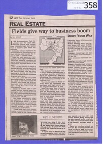
Newspaper clipping, Fields give way to business boom, 1993_
Tells some of the story of the settlement of Greensborough and Lend Leases' gradual take over of Greensborough shopping area. In Canberra Times Wednesday 17 November 1993, page 27: Melbourne: Lend Lease Corp Ltd is to undertake a $600 million redevelopment of two suburban Melbourne shopping centres, at Dandenong and Greensborough; to be built in conjunction with Australia's largest retailer; Coles Myer Ltd. The project will create about 2000 jobs; 1000 during construction and 1000 in long-term retail.Has some history of Greensborough and records the average land prices in 1993. A black and white Sunday Age newspaper story. Includes map and photograph of resident.greensborough, lend lease, 1993, land prices -
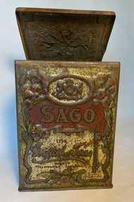 City of Moorabbin Historical Society (Operating the Box Cottage Museum)
Container - Griffiths Tea Canister, 1900-1940
In 1873 James Griffiths migrated to Melbourne in order to start a tea Business. James lived in the Dandenongs at The Basin where he experimented with growing tea. Griffiths made tin canisters in the 2lbs size for their tea with common kitchen consumables listed on the front . The tins, when emptied, became useful kitchen canisters and helped promote the brand. Example of the names include Flour, Rice, Sugar, Sago, Candied Peel, Tapioca, Spices, Starch, Biscuits, Currants, Barley, String and of course Tea .Food storage rectangular tin, with a hinged lid. The outside is printed in cream and red with the name 'Griffith's Teas' and the word 'SAGO'. The text is set against a cream panel which is bordered with a decorative border of Australian native flora. The whole is set against a dark green background.On each other side of the tin is a different native Australian flower. The lid is impressed with a flannel flower.Printed on the front 'SAGO', also printed on the front and repeated on the top 'USE / GRIFFITHS' Teas / SYDNEY / MELBOURNE. ADELAIDE. BRISBANE'. On the front is the image of a train signal with the words 'SIGNAL / TRADE MARK'tea, james griffiths, canisters, city of moorabbin, cheltenham, melbourne, moorabbin, grocery stores, kitchen equipment -
 Mt Dandenong & District Historical Society Inc.
Photograph, View of the Kalorama Valley c1905
John Lundy-Clarke grew up in the Kalorama/Mt Dandenong area and later in life (1972-74) began to write a comprehensive history of the area working from an original settlement map in an effort to cover all areas. This photograph c1905 is looking up from George Barber's house 'Forest Edge' on Barbers Road. 'Forest Edge' was built c1898 and was the home of George Barber and his wife Sarah Ann (nee Richardson). The buildings in the foreground are the stables and hayshed.Black and white photograph showing two small buildings in the foreground with cleared hills behind. Handwritten decription on back by John Lundy-ClarkeA 1905 view of the Kalorama Valley towards the Gap. Barbers stables in foreground with hayshed on left. Tait’s house in centre of picture with Logans in the same fold above the hayshed. “Kalorama” is centre of Gap with Paynter’s “Iona” on its left with stables to its left. It was from one of these trees on the top left that the runaway log was cut that leaped over Barbers Road (at the top edge of the cleared land) then over Logan’s house in one bound in 1930.george barber, sarah ann barber, john lundy-clarke, forest edge -
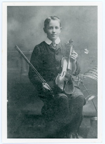 Mt Dandenong & District Historical Society Inc.
Photograph, Edward John Price aged 14
John Lundy-Clarke grew up in the Kalorama/Mt Dandenong area and later in life (1972-74) began to write a comprehensive history of the district working from an original settlement map in an effort to cover all areas. Edward John Price (1898 - 1974) was the son of early settlers on Lot 1 of the Village Settlement Edward Joseph Price and Annie (nee Ross) Price. He was the brother of Charles and Kathleen Price. Edward John married Myra Wilson in 1930.Black and white studio portrait showing well groomed boy holding a violin. Reverse of photograph has handwritten description by John Lundy-Clarke.Edward John Price aged 14. Son of Edward Joseph Price and Annie Ada nee Ross. Farmer, sawmiller, logging contractor,. proprietor of shop at Kew Junction 1935. Quarry master (Kilsyth). Father of Alan and Eddie J. A daughter died young. Married Myra Wilson 1930. Died 1974.edward john price, edward joseph price, annie price, annie ross, kathleen price, charles price -
Disability Sport & Recreation Victoria
DVD, 2011 Women's National Wheelchair Basketball League finals, 25/09/2011
The DVD features footage from two matches from the 2011 season of the Women's National Wheelchair Basketball League. The DVD features extended highlights from the second half of the game for 3rd/4th place, between the Perth Western Stars and North Sydney Bears. Following this game is the full recording of the championship game played between Victoria Dandenong Rangers and Sydney University Flames. These games were played at North Sydney Indoor Sports Centre in New South Wales.DVD in case2011 Women's National Wheelchair Basketball League finalswomen's national wheelchair basketball league, djuro sen, north sydney indoor sports centre, wheelchair basketball, gerry hewson, perth western stars, north sydney bears, victoria dandenong rangers, sydney university flames, dandenong rangers -
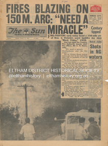 Eltham District Historical Society Inc
Newspaper - Newspaper articles, Sun News-Pictorial, Fires Blazing on 150M. Arc: "Need a Miracle", The Sun News-Pictorial, Tuesday, January 16, p1, 1962
Various news articles pertaining to the January 1962 Victorian bushfires in the Dandenong and Healesville districts which by second day had spread on to a 150 mile front fromDaylesford and Kinglake through to the Dandenongs. Specific Eltham Shire districts mentioned include Ninka Road, St. Andrews, Kinglake, Hurstbridge on page 2 • Fires Blazing on 150M. Arc: "Need a Miracle", p1 (Illust.) – Victoria’s worst bushfire day since “Black Friday,” 1939 • Night dash as bushfire sweeps by, p2 (Illust.) • Kalorama Saved: Fire 100 Ft. Away, p2 • Stay away, says police chief, p2 • The Tragedy of the Fires, p3 (Illust.) • Good save by firemen, p4 (Illust.) • S.E.C. Firemen Saved N. Yallourn, p4 • Cherry river of flame, p4 • From the fire front: Fire-fighters are bitten by snakes, p4 • They faced the fury, p6 (Illust.) • The ’39 Blaze, p6 • They fought and failed, p6 • Hills Aflame: 2nd Day, pp16-17 (Illust.) • Respite at Olinda HQ, p16 (Illust.) • Here is Ruin, p17 (Illust.) • This fireman had to work among piled up furniture … p32 (Illust.) tom fielding collection, victorian bushfires - 1962, victorian bushfires – 1962, black friday, victorian bushfires – 1939, c.h. howe, daylesford, country fire authority, dandenongs, yallourn, central gippsland, montrose, olinda, kalorama, healesville, st. andrews, hurstbridge, ninka road, kinglake, yarra glen, a.l. mccutcheon, st. andrews postmaster, eltham shire secretary, max watson, police commissioner porter, observatory road, mt. dandenong, whittlesea, one tree hill, sassafras, the basin, steel’s creek, ruby ryan, the basin progress hall, yaallourn, yallourn north, stet electricity commission (s.e.c.), hernes oak, mcdonalds track, florence milkins, lieutenant-colonel k. leggett, bonza view road, ringwood police station, michael o’connor, volunteers, fire damage - buildings -
 Ringwood and District Historical Society
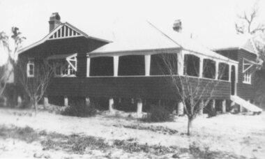
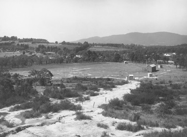
Photograph, East Ringwood oval c.1928
Typed below photograph, "View of East Ringwood oval from present site of Civic Centre. Mt. Dandenong Rd. on right - 1935". Catalogue card reads, "Suggest this photo is taken early 1920s.... E.R.F.C. was established approx. 1928. Prior to this the Ringwood F.C. played on the oval". -
 Jewish Museum of Australia
Chess set
This chess set was carved from local wood with bases made from halved cotton reels. The chess pieces take the shape of Australian animals, and Aboriginal men and women. The set was presented to Mr. Benzion Patkin, Honorary Secretary of the Zionist Federation of Australia, by Tatura internees in recognition of his assistance, in particular, his assistance in facilitating the emigration to Palestine. According to Mr. Patkin, he received the chess set in a wooden box inscribed, "With our sincerest thanks from your Zionist friends - Tatura, on the way to Eretz Israel, per Leonhard Levin, 20.11.1942.".Written in pencil UR corner, upside down: (22) Printed in black ink: "B. & H. PATKIN Flat (printed 2 corrected in pen and ink 4) 313a Dandenong Road Windsor 3181 Victoria Australia Tel: Home 51 - 5671 Bus 63 - 8959"dunera, wwii, internees, jewish history & people -
 Ringwood and District Historical Society
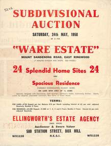
Flyer, Subdivisional Auction Sale Brochure, Ware Estate, East Ringwood, Vic. - 1958
Folded double-sided advertisement for auction of 24 home sites and existing residence on Saturday, 24th May, 1958, including locality map, subdivision layout, terms of sale, and summary of local facilities and services. Additional plan of lots 28-33 dated 26/10/60 by Licensed Surveyor for Kirkpatrick & Webber, 225 Maroondah Highway Ringwood headed Plan of Subdivision of part of Crown Allotment 26A Parish of Ringwood.Subdivision includes Mount Dandenong Road, Ware Crescent, Davey Drive, and Grey Road (later Grey Street). Timber residence included in the subdivision was formerly Ware Kindergarten Holiday Home. (Agent) Ellingworth's Estate Agency, 580 Station Street, Box Hill - (Phone) WX1228. -
 Whitehorse Historical Society Inc.
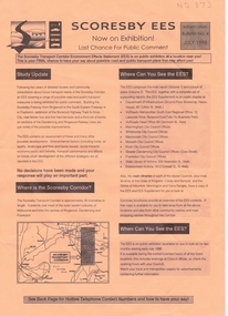
Pamphlet, Scoresby EES, 1/07/1998 12:00:00 AM
Information bulletin on the Scoresby Transport CorridorInformation bulletin on the Scoresby Transport Corridor on exhibition for public comment. It covers major possible transport projects in the area between Ringwood and Frankston including freeways, extensions to the Burwood tram line and the Glen Waverley Rail line.Information bulletin on the Scoresby Transport Corridorfreeways, scoresby transport corridor environment effects statement, ringwood, south eastern freeway, frankston, burwood highway, dandenong, victoria, libraries, transport, land use, springvale road burwood, burwood, tram services -
 Whitehorse Historical Society Inc.
Functional object - Post Box
Receiver was obtained from Supply Branch of Telecom Australia. It was located by Harold Bakes (early member of the Nunawading Historical Society) at the Hawthorn Line depot and Society purchased. It was stored at the former City of Nunawading Depot in Station Street, Nunawading. It was noticed by Postal Services when they were building the Nunawading Mail Exchange and loaned to them whilst it remained in the City of Nunawading at the Mail Exchange. The had it refurbished and it stood in the Mail Exchange vestibule. When the exchange closed it was taken to Dandenong. It took much negotiation before it was returned to the Society.Alternative Name: Letter Receiver Large round cast iron Letter Receiver surmounted with a gold crown on domes to pointed top. Top has a gold cast iron fancy fringe and below on the main body a further gold plain fringe. Door follows the contour of the round receiver and cover about on of the body. Handle of door is in shape of a fist painted gold. Receiver is mounted on a cast iron base (could have been all cast together) approx 3/8 of the overall height of 250cm. Receiver is painted Pillar Box Red - base which is placed in ground is mid green. From a similar Receiver installed near the Prahran Railway it would appear that half of the base is above ground. Station It has five oblong holes. Cast into the body between the two fringes are a letter opening and two words POST OFFICE and Receiving Pillar.Cast into Receiver - POST OFFICE / Letter Receiver In door - transfer with crown and E11Rcommunication, postal, historical society -
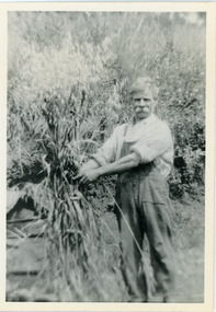 Mt Dandenong & District Historical Society Inc.
Photograph, Robert Logan
Robert Logan took up Lot 28 in the Village Settlement in 1896 and worked it until his death in 1936. His second son, Malcolm, took over the selection and continued to work it until he married and then it was subdivided. This photograph shows the oats that Robert Logan grew to feed his horse. John Lundy-Clarke grew up in the Kalorama/Mt Dandenong area and later in life (1972-74) began to write a comprehensive history of the area working from an original settlement map in an effort to cover all areas.Black and white photograph of a white haired man with a large white moustache man wearing overalls tying up a sheaf of hay. Handwritten description on reverse by John Lundy-Clarke.Robert Logan with hay grown on LOT 28 SECTION 1 of the Village Settlement. He was the original selector and his LOT was the last worked fully (by his son Malcolm) in SECTION 1. 1920. robert logan, logan, malcolm logan, kalorama, john lundy-clarke -
 Ballarat Tramway Museum
Album, Brian Andrews, UR1 - 300 Photo - Bendigo, Ballarat trams, 1968
Album compiled by the photographer containing generally 89 x 124mm of: • Bendigo – 151 black and white prints • Ballarat – 119 black and white prints and some colour • Melbourne – 20 colour and black and white prints - featuring Queensway, the Hump, Royal Park, route 82, Dandenong Road, Glenferrie Road, Barkers Road and Hawthorn Bridge. • Rome, Hong Kong and Toronto – 14 prints See items 8638 to 8642 for negatives of the Ballarat and Bendigo photos and related image files held on the BTM Demonstrates the work of the photographer.Album - heavy plastic covered covers, with 100 sewn and glued paper sheets each side with three plastic sleeves for photographs with a negative pocket page at the rear. See list of btm8637 - Ballarat list.doc for a location listing of the Ballarat photographs.trams, tramways, ballarat, bendigo, melbourne, hong kong, toronto, rome, brian andrews -
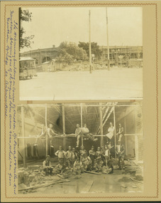 Kew Historical Society Inc
Photograph - Hawthorn Tram Depot during construction, 1915
One of a series of photographs, taken by Edgar James Dower in the second decade of the twentieth century. Born and raised in Olinda, his family later moved to Surrey Hills. He worked as an adult as a clerk in the city office of the Metropolitan Gas Company, and in his role as a 'collector', he was able to photograph scenes including the construction of tramlines and associated buildings in Kew, Hawthorn, Camberwell and Surrey Hills. Later he established a real estate agency with his brother - the E.J. Dower Real Estate Agency, Dandenong Office.The image is an historically significant record of the development of transport infrastructure which was used to connect Victorians in the first two decades of the twentieth century. This development resulted from increases in population and the consequent extension of Melbourne's suburbs. The photographs, both individually and collectively, richly detail the labour of workers and the tools and machinery used to create and extend Melbourne's tram network in the years preceding and during World War 1.Two faded original horizontal photographs, mounted on vertical card showing external and internal features of the Hawthorn Tram Depot during its construction phase. The top photo shows a panoramic view of the exterior while the second photo shows workers posed within the building.Recto: "The tramways building in course of creation. C/r of Power St & Wallen Road, Hawthorn. Showing one of the original horse drawn trams which ran from Hawthorn Bridge to Auburn Road".. theme --- travelling by tram, theme -- connecting victorians by transport and communications, tramways -- hawthorn -
 Kew Historical Society Inc
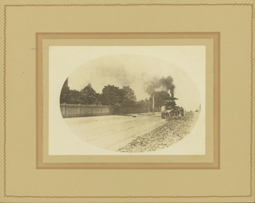
Photograph - Removal of the horse tram line in Riversdale Road, Hawthorn, E.J. Dower, c.1916
One of a series of photographs, taken by Edgar James Dower in the second decade of the twentieth century. Born and raised in Olinda, his family later moved to Surrey Hills. He worked as an adult as a clerk in the city office of the Metropolitan Gas Company, and in his role as a 'collector', he was able to photograph scenes including the construction of tramlines and associated buildings in Kew, Hawthorn, Camberwell and Surrey Hills. Later he established a real estate agency with his brother - the E.J. Dower Real Estate Agency, Dandenong Office.The image is an historically significant record of the development of transport infrastructure which was used to connect Victorians in the first two decades of the twentieth century. This development resulted from increases in population and the consequent extension of Melbourne's suburbs. The photographs, both individually and collectively, richly detail the labour of workers and the tools and machinery used to create and extend Melbourne's tram network in the years preceding and during World War 1.Digital copy of an original mounted photograph of the removal of the horse tram tracks in Riversdale Road, Hawthorn, in preparation for laying the new electric tramline.Annotated verso: "Pulling up Hawthorn horse tram line in Riversdale Road, which ran from Hawthorn Bridge to Auburn Road"theme --- travelling by tram, theme -- connecting victorians by transport and communications, trams -- boroondara (vic.), horse tram -- hawthorn (vic.), riversdale road -
 Kew Historical Society Inc
Photograph - Construction of the electric tram line in Riversdale Road, Surrey Hills, E.J. Dower, 1916
One of a series of photographs, taken by Edgar James Dower in the second decade of the twentieth century. Born and raised in Olinda, his family later moved to Surrey Hills. He worked as an adult as a clerk in the city office of the Metropolitan Gas Company, and in his role as a 'collector', he was able to photograph scenes including the construction of tramlines and associated buildings in Kew, Hawthorn, Camberwell and Surrey Hills. Later he established a real estate agency with his brother - the E.J. Dower Real Estate Agency, Dandenong Office.The image is an historically significant record of the development of transport infrastructure which was used to connect Victorians in the first two decades of the twentieth century. This development resulted from increases in population and the consequent extension of Melbourne's suburbs. The photographs, both individually and collectively, richly detail the labour of workers and the tools and machinery used to create and extend Melbourne's tram network in the years preceding and during World War 1.Digital copy of an original oval mounted photograph of the construction of the tracks for the new electric tramline in Riversdale Road, Surrey Hills. Annotated verso: "Preparing for electric tram line, Riversdale Road, Surrey Hills / Taken from near Warrigul [sic] Road / note Essex Road on right with picket fencing."theme --- travelling by tram, theme -- connecting victorians by transport and communications, trams -- boroondara (vic.), riversdale road -- surrey hills -
 Kew Historical Society Inc
Photograph - Construction of the electric tram line in Riversdale Road, Camberwell, E.J. Dower, 1916
One of a series of photographs, taken by Edgar James Dower in the second decade of the twentieth century. Born and raised in Olinda, his family later moved to Surrey Hills. He worked as an adult as a clerk in the city office of the Metropolitan Gas Company, and in his role as a 'collector', he was able to photograph scenes including the construction of tramlines and associated buildings in Kew, Hawthorn, Camberwell and Surrey Hills. Later he established a real estate agency with his brother - the E.J. Dower Real Estate Agency, Dandenong Office.The image is an historically significant record of the development of transport infrastructure which was used to connect Victorians in the first two decades of the twentieth century. This development resulted from increases in population and the consequent extension of Melbourne's suburbs. The photographs, both individually and collectively, richly detail the labour of workers and the tools and machinery used to create and extend Melbourne's tram network in the years preceding and during World War 1.Digital copy of an original oval mounted photograph depicting preparation for laying the tracks for the new electric tramline in Riversdale Road, Camberwell. Annotated verso: "Riversdale Road / Preparing for electric tram line / Taken from near corner of Coolangatta Road"theme --- travelling by tram, theme -- connecting victorians by transport and communications, riversdale road -- camberwell, trams -- camberwell -
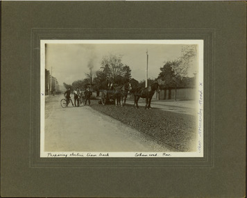
 Kew Historical Society Inc
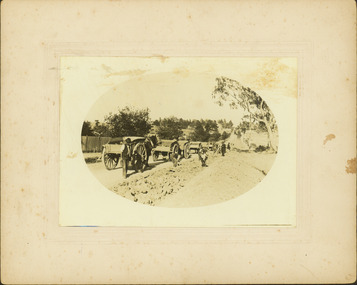
Photograph - Electric tram line construction in Cotham Road, Kew, E.J. Dower, 1913
One of a series of photographs, taken by Edgar James Dower in the second decade of the twentieth century. Born and raised in Olinda, his family later moved to Surrey Hills. He worked as an adult as a clerk in the city office of the Metropolitan Gas Company, and in his role as a 'collector', he was able to photograph scenes including the construction of tramlines and associated buildings in Kew, Hawthorn, Camberwell and Surrey Hills. Later he established a real estate agency with his brother - the E.J. Dower Real Estate Agency, Dandenong Office.The image is an historically significant record of the development of transport infrastructure which was used to connect Victorians in the first two decades of the twentieth century. This development resulted from increases in population and the consequent extension of Melbourne's suburbs. The photographs, both individually and collectively, richly detail the labour of workers and the tools and machinery used to create and extend Melbourne's tram network in the years preceding and during World War 1.Digital copy of an original mounted photograph depicting construction of a new electric tramline in Cotham Road, Kew. The photo shows workers with an early steamroller.Annotated verso: "Preparing for electric trams / Cotham Road Kew / Taken near Barrington Avenue / 1913"theme --- travelling by tram, theme -- connecting victorians by transport and communications, cotham road -- kew (vic.), trams -- kew (vic.) -
 Kew Historical Society Inc
Photograph - Electric tram line construction in Cotham Road, Kew, E.J. Dower, 1913
One of a series of photographs, taken by Edgar James Dower in the second decade of the twentieth century. Born and raised in Olinda, his family later moved to Surrey Hills. He worked as an adult as a clerk in the city office of the Metropolitan Gas Company, and in his role as a 'collector', he was able to photograph scenes including the construction of tramlines and associated buildings in Kew, Hawthorn, Camberwell and Surrey Hills. Later he established a real estate agency with his brother - the E.J. Dower Real Estate Agency, Dandenong Office.The image is an historically significant record of the development of transport infrastructure which was used to connect Victorians in the first two decades of the twentieth century. This development resulted from increases in population and the consequent extension of Melbourne's suburbs. The photographs, both individually and collectively, richly detail the labour of workers and the tools and machinery used to create and extend Melbourne's tram network in the years preceding and during World War 1.Digital copy of an original mounted photograph depicting construction of a new electric tramline in Cotham Road, Kew. The photo shows a worker standing on the tracks at the then terminus.Annotated verso: "Preparing for electric trams / Cotham Road Kew / Taken from corner of Burke Road / 1913"theme --- travelling by tram, theme -- connecting victorians by transport and communications, cotham road -- kew (vic.), trams -- kew (vic.) -
 Kew Historical Society Inc
Photograph - Electric tram line construction in Cotham Road, Kew, E.J. Dower, 1913
One of a series of photographs, taken by Edgar James Dower in the second decade of the twentieth century. Born and raised in Olinda, his family later moved to Surrey Hills. He worked as an adult as a clerk in the city office of the Metropolitan Gas Company, and in his role as a 'collector', he was able to photograph scenes including the construction of tramlines and associated buildings in Kew, Hawthorn, Camberwell and Surrey Hills. Later he established a real estate agency with his brother - the E.J. Dower Real Estate Agency, Dandenong Office.The image is an historically significant record of the development of transport infrastructure which was used to connect Victorians in the first two decades of the twentieth century. This development resulted from increases in population and the consequent extension of Melbourne's suburbs. The photographs, both individually and collectively, richly detail the labour of workers and the tools and machinery used to create and extend Melbourne's tram network in the years preceding and during World War 1.Digital copy of an original mounted photograph depicting construction of a new electric tramline in Cotham Road, Kew. The photo shows workers and a steamroller. The spire of the Kew Presbyterian Church can be seen in the distance.Annotated verso: "Preparing for electric trams / Cotham Road Kew / Taken near Barrington Avenue / Taken by E.J. Dower / 1913"theme --- travelling by tram, theme -- connecting victorians by transport and communications, cotham road -- kew (vic.), trams -- kew (vic.) -
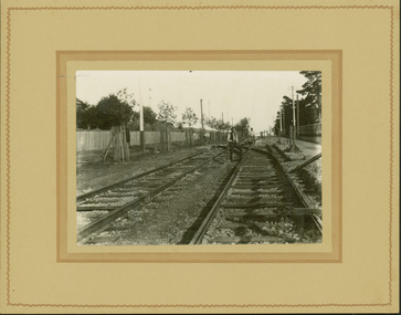
 Kew Historical Society Inc
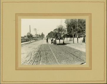
Photograph - Electric tram line construction in Cotham Road, Kew, E.J. Dower, 1913
One of a series of photographs, taken by Edgar James Dower in the second decade of the twentieth century. Born and raised in Olinda, his family later moved to Surrey Hills. He worked as an adult as a clerk in the city office of the Metropolitan Gas Company, and in his role as a 'collector', he was able to photograph scenes including the construction of tramlines and associated buildings in Kew, Hawthorn, Camberwell and Surrey Hills. Later he established a real estate agency with his brother - the E.J. Dower Real Estate Agency, Dandenong Office.The image is an historically significant record of the development of transport infrastructure which was used to connect Victorians in the first two decades of the twentieth century. This development resulted from increases in population and the consequent extension of Melbourne's suburbs. The photographs, both individually and collectively, richly detail the labour of workers and the tools and machinery used to create and extend Melbourne's tram network in the years preceding and during World War 1.Digital copy of an original mounted photograph depicting construction of a new electric tramline in Cotham Road, Kew. The photo shows both a horse drawn and steam roller. A works supervisor and two men on bikes stand on the road to the left of the horse drawn roller. Annotated recto: "Preparing electric tram track / Cotham Road Kew / Near Normanby Road x. Annotated verso: "Preparing for electric tram / Cotham Road Kew / Taken near Normanby Road.theme --- travelling by tram, theme -- connecting victorians by transport and communications, cotham road -- kew (vic.), trams -- kew (vic.) -
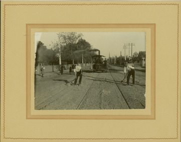
 Kew Historical Society Inc
Photograph - Electric tram line construction on the corner of Cotham & Glenferrie Roads, Kew, E.J. Dower, 1913
One of a series of photographs, taken by Edgar James Dower in the second decade of the twentieth century. Born and raised in Olinda, his family later moved to Surrey Hills. He worked as an adult as a clerk in the city office of the Metropolitan Gas Company, and in his role as a 'collector', he was able to photograph scenes including the construction of tramlines and associated buildings in Kew, Hawthorn, Camberwell and Surrey Hills. Later he established a real estate agency with his brother - the E.J. Dower Real Estate Agency, Dandenong Office.The image is an historically significant record of the development of transport infrastructure which was used to connect Victorians in the first two decades of the twentieth century. This development resulted from increases in population and the consequent extension of Melbourne's suburbs. The photographs, both individually and collectively, richly detail the labour of workers and the tools and machinery used to create and extend Melbourne's tram network in the years preceding and during World War 1.Digital copy of an original mounted photograph depicting construction of a new electric tramline taken near the corner of Cotham and Glenferrie Roads, Kew. In 1913, trams could turn left or right into Cotham Road from Glenferrie Road. The photo shows workers constructing the tracks.Annotated recto: "Construction of Electric Tram Line / car Cotham & Glenferrie Ads Kew / 1913". . Annotated verso: "Taken by E.J. Dower 1913"theme --- travelling by tram, theme -- connecting victorians by transport and communications, cotham road -- kew (vic.), trams -- kew (vic.), glenferrie road -- kew (vic.) -
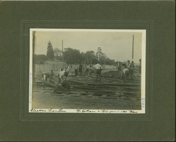
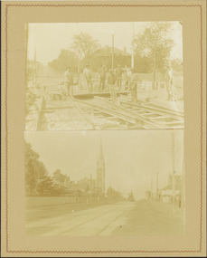 Kew Historical Society Inc
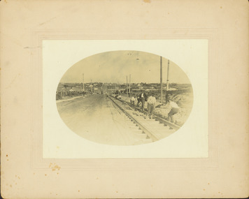
Photograph - Electric tram line construction in Cotham Road, Kew, E.J. Dower, 1913
One of a series of photographs, taken by Edgar James Dower in the second decade of the twentieth century. Born and raised in Olinda, his family later moved to Surrey Hills. He worked as an adult as a clerk in the city office of the Metropolitan Gas Company, and in his role as a 'collector', he was able to photograph scenes including the construction of tramlines and associated buildings in Kew, Hawthorn, Camberwell and Surrey Hills. Later he established a real estate agency with his brother - the E.J. Dower Real Estate Agency, Dandenong Office.The image is an historically significant record of the development of transport infrastructure which was used to connect Victorians in the first two decades of the twentieth century. This development resulted from increases in population and the consequent extension of Melbourne's suburbs. The photographs, both individually and collectively, richly detail the labour of workers and the tools and machinery used to create and extend Melbourne's tram network in the years preceding and during World War 1.Digital copy of two original mounted photographs depicting construction of a new electric tramline in Cotham Road, Kew. The upper photo shows workers standing among the newly laid tracks. The lower photo shows the vista of Cotham Road looking east towards the Kew Presbyterian Church on the corner of Highbury Road. Annotated verso: "Cotham Road Kew / Taken by E.J. Dower 1913"theme --- travelling by tram, theme -- connecting victorians by transport and communications, cotham road -- kew (vic.), trams -- kew (vic.)