Showing 913 items
matching mr sides
-
 Kew Historical Society Inc
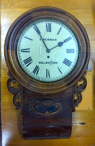
Functional object, H Newman, Boxed Wall Clock, 19th Century
DEATH OF MR. H. NEWMAN. Widespread regret will be felt at the announcement of the death of Mr Henry Newman, an old colonist and a member of firm of Newman and Sons Proprietary Limited, jewellers, which occurred at his residence, "Sadova," William street, on Saturday, at the age of 89 years. Mr Newman who was born at Riga, in Russia, went to England when a lad, became naturalised, and emigrated to Victoria 61 years ago. He tried his fortune at Ballarat but soon afterwards returned to Melbourne, and began business as a jeweller, on a site in Collins street that is now occupied by Scott's Hotel. A few years later Mr Newman went back to England, where he was married. On his return to Victoria again he resumed his jewellery business in Elizabeth street opposite the General Post-office. An interesting fact in connection with his business is that his first journeyman watchmaker was Mr. Thomas Gaunt, the founder of the firm of Messrs. T. Gaunt & Co. Five years ago Mr. Newman retired from the business, which has since been carried on by his two elder sons. Although he took no active part in public affairs, Mr Newman was held in high regard on account of his business integrity, sterling personal worth. and the unostentatious way in which he did good. His vitality, even in his later years, was wonderful. On four occasions he met with accidents, having been twice knocked down by motorcars and twice by trams, without having sustained injury. A widow and grown up family of four sons and four daughters survive him. The Age Monday 27 October 1913, page 9. Roy Cronin 156 High Street Kew Jeweller and watchmaker. East side between Denmark Street and Cotham Road. Wood, enamel, brass and glass wall clock, the movement made by H Newman of Collins Street, Melbourne. A small label on the interior records the name R. Cronin, 156 High St, Kew, 1/7/20. It is unclear whether Cronin, a watchmaker and jeweller may have repaired or sold the clock. The clock (broken) is housed in a steel box.roy cronin - watchmaker - jeweller - kew (vic), h newman - melbourne (vic) - collins street - jeweller - clockmaker -
 Kew Historical Society Inc
Photograph, Marnie McLeod, Floods of the River Yarra at Kew, 1916
The donation was accompanied by the following letter from the donor: "Hi. I found these in with family photos. Taken by family as Mamie McLeod was living in Fellows Street, Kew, so would be near there. Retain (or discard) as you see fit." [Donor's name and address withheld from public view]. To gain an insight into the flood levels at Kew, it is worth reading newspaper accounts of the event. The Age published an article - Valuable Gardens Destroyed at Kew - on 25 September 1916: "VALUABLE GARDENS DESTROYED AT KEW. From the heights of Studley Park, Kew, a splendid view of the flood waters can be obtained, and yesterday afternoon, despite continuous rain, crowds of citizens assembled there to witness the spectacle. There is a vast stretch of water some 300 or 400 yards broad, above the foot bridge connecting Gipps-street, Collingwood, and Studley Park. The river is only about 3 feet from the top of the embankment connecting with the ramp of the bridge on the Studiey Park side. When the upper llood waters come down it is almost a certainty that tne embankment will be submerged and the bridge rendered impassible. Below the bridge the waters again stretch out, and have submerged all the low-lying land on the Collingwood side and invaded the back premises ot the Kodak Co., Phoenix Biscuit Factory, a tannery adjoining thereto, the Shamrock Brewery, and Chinese gardens in the vicinity. At Walmer-street-bridge, at the end of Studley Park, the low-lying land on the Kew side is covered with water to the depth of many feet. Tlie land in question is owned in a great part by Mr Frank Lavers who haa gone in for intense culture on a pretty liberal scale on both the slopes of the hill and on the river flat. On the latter he is cultivating many acres of asparagus, and has at a considerable cost spent three years in preparing the ground and installing an irrigation system, reticulated from the Yan Yean water supply. This year the asparagus was put down, and the plants were in a promising condition. Tlie flood waters are now flowing fast over the land. The crop is ruined, and three years' work and expenditure destroyed. Mr. Laver's private residence fortunately is high above flood level, but two houses he owns off Young-street have been flooded out. Having been warned in time, the tenants removed their furniture hefore the water came down to Mr. Laver's residence, where they themselves have been given accommodation in the meantime. All the river flats in East Kew are under water. One or two low-lying houses have been flooded. Chipperfield's boat shed at Willsmere is nearly covered, and some Chinese gardens in the vicinity are several feet under water."This, and the other three photographs donated of floods in Kew are believed to be the earliest in the collection. Together with our original MMBW River Yarra map showing flood levels, these items, when compared allow researchers to gain a visual perspective of the extent of the flood in 1916. Black and white photograph of flooded trees in Kew with rising dry ground in distance.Inscription on reverse in pencil: "Flood River Yarra Kew Vic"river yarra, kew, floods 1916 -
 Kew Historical Society Inc
Photograph, Marnie McLeod, Floods on the River Yarra at Kew, 1916
The donation was accompanied by the following letter from the donor: "Hi. I found these in with family photos. Taken by family as Mamie McLeod was living in Fellows Street, Kew, so would be near there. Retain (or discard) as you see fit." [Donor's name and address withheld from public view]. To gain an insight into the flood levels at Kew, it is worth reading newspaper accounts of the event. The Age published an article - Valuable Gardens Destroyed at Kew - on 25 September 1916: "VALUABLE GARDENS DESTROYED AT KEW. From the heights of Studley Park, Kew, a splendid view of the flood waters can be obtained, and yesterday afternoon, despite continuous rain, crowds of citizens assembled there to witness the spectacle. There is a vast stretch of water some 300 or 400 yards broad, above the foot bridge connecting Gipps-street, Collingwood, and Studley Park. The river is only about 3 feet from the top of the embankment connecting with the ramp of the bridge on the Studiey Park side. When the upper llood waters come down it is almost a certainty that tne embankment will be submerged and the bridge rendered impassible. Below the bridge the waters again stretch out, and have submerged all the low-lying land on the Collingwood side and invaded the back premises ot the Kodak Co., Phoenix Biscuit Factory, a tannery adjoining thereto, the Shamrock Brewery, and Chinese gardens in the vicinity. At Walmer-street-bridge, at the end of Studley Park, the low-lying land on the Kew side is covered with water to the depth of many feet. Tlie land in question is owned in a great part by Mr Frank Lavers who haa gone in for intense culture on a pretty liberal scale on both the slopes of the hill and on the river flat. On the latter he is cultivating many acres of asparagus, and has at a considerable cost spent three years in preparing the ground and installing an irrigation system, reticulated from the Yan Yean water supply. This year the asparagus was put down, and the plants were in a promising condition. Tlie flood waters are now flowing fast over the land. The crop is ruined, and three years' work and expenditure destroyed. Mr. Laver's private residence fortunately is high above flood level, but two houses he owns off Young-street have been flooded out. Having been warned in time, the tenants removed their furniture hefore the water came down to Mr. Laver's residence, where they themselves have been given accommodation in the meantime. All the river flats in East Kew are under water. One or two low-lying houses have been flooded. Chipperfield's boat shed at Willsmere is nearly covered, and some Chinese gardens in the vicinity are several feet under water."This, and the other three photographs donated of floods in Kew are believed to be the earliest in the collection. Together with our original MMBW River Yarra map showing flood levels, these items, when compared allow researchers to gain a visual perspective of the extent of the flood in 1916. Panoramic view, believed to be looking north towards Fairfield from the Zig-Zag Bridge on the River Yarra. The inscription on the reverese identifies it as taken before 1920.Inscription on reverse in ink "(pre 1920) Flood from Zig-zag bridge Yarra River, Kew Vic."river yarra, kew, floods 1916, zig-zag bridge -
 Kew Historical Society Inc
Photograph, Marnie McLeod, Flood, River Yarra, Kew, 1916
The donation was accompanied by the following letter from the donor: "Hi. I found these in with family photos. Taken by family as Mamie McLeod was living in Fellows Street, Kew, so would be near there. Retain (or discard) as you see fit." [Donor's name and address withheld from public view]. To gain an insight into the flood levels at Kew, it is worth reading newspaper accounts of the event. The Age published an article - Valuable Gardens Destroyed at Kew - on 25 September 1916: "VALUABLE GARDENS DESTROYED AT KEW. From the heights of Studley Park, Kew, a splendid view of the flood waters can be obtained, and yesterday afternoon, despite continuous rain, crowds of citizens assembled there to witness the spectacle. There is a vast stretch of water some 300 or 400 yards broad, above the foot bridge connecting Gipps-street, Collingwood, and Studley Park. The river is only about 3 feet from the top of the embankment connecting with the ramp of the bridge on the Studiey Park side. When the upper llood waters come down it is almost a certainty that tne embankment will be submerged and the bridge rendered impassible. Below the bridge the waters again stretch out, and have submerged all the low-lying land on the Collingwood side and invaded the back premises ot the Kodak Co., Phoenix Biscuit Factory, a tannery adjoining thereto, the Shamrock Brewery, and Chinese gardens in the vicinity. At Walmer-street-bridge, at the end of Studley Park, the low-lying land on the Kew side is covered with water to the depth of many feet. Tlie land in question is owned in a great part by Mr Frank Lavers who haa gone in for intense culture on a pretty liberal scale on both the slopes of the hill and on the river flat. On the latter he is cultivating many acres of asparagus, and has at a considerable cost spent three years in preparing the ground and installing an irrigation system, reticulated from the Yan Yean water supply. This year the asparagus was put down, and the plants were in a promising condition. Tlie flood waters are now flowing fast over the land. The crop is ruined, and three years' work and expenditure destroyed. Mr. Laver's private residence fortunately is high above flood level, but two houses he owns off Young-street have been flooded out. Having been warned in time, the tenants removed their furniture hefore the water came down to Mr. Laver's residence, where they themselves have been given accommodation in the meantime. All the river flats in East Kew are under water. One or two low-lying houses have been flooded. Chipperfield's boat shed at Willsmere is nearly covered, and some Chinese gardens in the vicinity are several feet under water."This, and the other three photographs donated of floods in Kew are believed to be the earliest in the collection. Together with our original MMBW River Yarra map showing flood levels, these items, when compared allow researchers to gain a visual perspective of the extent of the flood in 1916. Small black and white photograph of flooded trees in Kew.Inscription on reverse in ink "Flood R. Yarra Kew Vicriver yarra, kew, floods 1916 -
 Kew Historical Society Inc
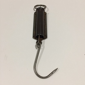
Equipment - Weighing Instrument, Pocket Balance, Twentieth Century
Small hanging scales at the top of which there is a metallic ring to fasten the object. This is attached to the main body which on one side has measurements inscribed into the metal surface. Inside the body is a spring loaded mechanism which moves along the scales when weight is added to a hook at the bottom of the shaft. [Ed. The maker's initials have not to date been identified.]"Pocket Balance / MR Product / Made in Australia"pocket balance, hanging scales, weighing instrument -
 Kew Historical Society Inc
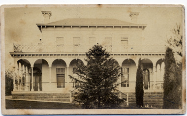
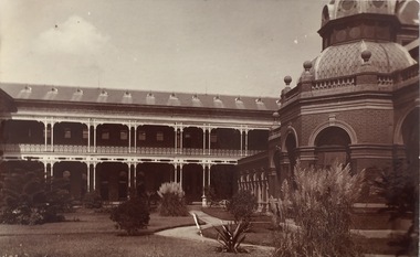
Photograph - 'Clutha', Studley Park Road, 1860-1890
Clutha was the home of John Carson, the second mayor of Kew. Leonard Terry designed the house for him in 1856. Terry was the architect of the Melbourne Club (1858), the former London Chartered Bank (1861), Lothian Terrace in Carlton (1865), and the ES&A Bank in Hawthorn (1873). The commission for Clutha was won three years after Terry’s arrival in Victoria.An extremely rare photograph of a major residential architectural commission of Leonard Terry. The photograph of the house has statewide significance as the home of the Victorian pioneer and businessman, John Carson. A rare, nineteenth century photograph of ‘Clutha’ in Studley Park Road, Kew. The sepia-toned photograph is of the front of the house, with its bluestone foundations and its second storey balcony. A real estate advertisement in 1875 described the house as: 'First-class family mansion, and about 8½ acres of pleasure grounds and fruit garden. The house, erected under the plans and supervision of Mr. Leonard Terry, is most substantially built of brick, stuccoed, on solid bluestone pediment, forming a noble basement story, large entrance hall, and lobby, with conservatory on the left. *** A wide verandah and balcony, erected on cast-iron columns, runs round the house, the views from which are perhaps unequalled in extent and beauty in the neighbourhood of the city, commanding the bay, shipping, Mount Macedon, and Dandenong Ranges. Th e whole forming a most complete gentleman's residence, no expense having been spared in its erection and comfortable finish.'"Clutha West Side Studley Park Road Kew / Clutha West Side"clutha, john carson, leonard terry -
![View of Victoria Hill, Bendigo, taken from Old Chum Hill / [by] Nicholas Caire, circa 1876](/media/collectors/550653872162f11fb04854aa/items/577752a3d0cdd10a5c16e654/item-media/57775308d0cdd10a5c171c46/item-fit-380x285.jpg) Kew Historical Society Inc
Kew Historical Society IncPhotograph, Anglo-Australasian Photographic Company, View of Victoria Hill, Bendigo, taken from Old Chum Hill, c. 1876
Nicholas Caire was born on Guernsey in the Channel Islands in 1837. He arrived in Adelaide with his parents in about 1860. In 1867, following photographic journeys in Gippsland, he opened a studio in Adelaide. From 1870 to 1876 he lived and worked in Talbot in Central Victoria. In 1876 he purchased T. F. Chuck's studios in the Royal Arcade Melbourne. In 1885, following the introduction of dry plate photography, he began a series of landscape series, which were commercially successful. As a photographer, he travelled extensively through Victoria, photographing places few of his contemporaries had previously seen. He died in 1918. Reference: Jack Cato, 'Caire, Nicholas John (1837–1918)', Australian Dictionary of Biography.An original, rare photograph from the series 'Views of Victoria: General Series' by the photographer, Nicholas Caire (1837-1918). The series of 60 photographs that comprise the series was issued c. 1876 and reinforced a neo-Romantic view of the Australian landscape to which a growing nationalist movement would respond. Nicholas Caire was active as a photographer in Australia from 1858 until his death in 1918. His vision of the Australian bush and pioneer life had a counterpart in the works of Henry Lawson and other nationalist poets, authors and painters.Albumen silver photograph on boardprinted in ink on support l.c.: VIEW OF STURT STREET, BALLARAT, TAKEN FROM THE TOWN HALL TOWER. / COPYRIGHT REGISTERED. printed in ink on support reverse c.: VIEWS OF VICTORIA. / (GENERAL SERIES.) / No. 13. / VIEW OF VICTORIA HILL, BENDIGO, TAKEN FROM OLD CHUM HILL. / This scene represents two of the principal Quartz-reef claims in the district of Bendigo, with their surface / excavations. The one nearest the foreground is the North Old Chum's Company's claim, which is very rich with / gold-bearing quartz. The other claim, on the hill side, is the private property of Mr. George Lansell, and is even / more valuable than the former, giving employment to over 100 men. The building on the right is the quartz-crushing / plant belonging to the new Chum and Victoria Companies. The excavations are several hundred feet in depth. printed in ink on support reverse l.c.l.: J.W. FORBES, Agent, printed in ink on support reverse l.c.: ANGLO-AUSTRALASIAN PHOTOGRAPHIC COMPANY, MELBOURNE. printed in ink on support reverse l.c.r.: 10 Temple Court, Collins Street West.nicholas caire (1837-1918), landscape photography, victoria hill - bendigo - victoria -
 Kew Historical Society Inc
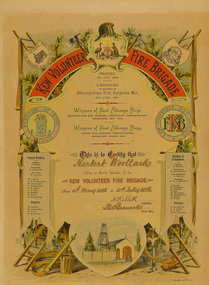
Document, Troedel & Co, Kew Volunteer Fire Brigade, Certificate of Membership, 1886
1879 - The Argus, Friday 11 July 1879, page 4. The Kew Borough Council having decided to initiate a fire brigade, invited volunteers to send in their names. About 40 complied with the invitation and met at the Town-hall to choose 12 of their number to form the brigade. The 12 elected then chose their officers as follows :— Councillor Gray, captain ; Mr. Thomas Greenhill, foreman ; and Mr. H. Loxton, secretary. The brigade decided to apply to the council for uniforms and a bell; and after adopting rules for their guidance the meeting separated. The brigade now possesses a reel and 500ft. of hose, and a shed is being erected in Little Walpole-street for a station. The council have applied for six additional fireplugs in the Main-road, so that the brigade may now be considered fairly established. The Volunteer Fire Brigade was replaced in 1891 by a detachment of the Metropolitan Fire Brigade and a new Fire Station in Walton Street constructed in 1893; subsequently demolished in 1941.The certificate includes the only known image of the first fire station in Kew. It was donated by Mrs L. Bray. The donor's father, Mr. A. Wood, was a member at time of the Brigade's 'disbandment'.Kew Volunteer Fire Brigade: Certificate of Membership, 1886. Testifying that Herbert Woollard was an active member of the Kew Volunteer Fire Brigade between 4th May 1883 and 2nd July 1886. Signed with pen and ink H. Kellett (Captain) and F.G.A. Barnard (Hon. Sec.). The certificate is believed to include the only picture of the first Kew Fire Station.The certificate lists the original members of the brigade on the left side as: Captain H. Gray, Lieutenant T. Greenhill, and Secretary H. Loxton; [Members} F.G.A. Barnard, W. Cleverdon, L. Gurzanscky, T.G. Jellis, J.A. Kay, H. Kellett, H. Kirby, D. McLachlan; (Honorary members) W. Atkins, W. Cleverdon, H. Gray, T. Greenhill. At the right is a list of members at the time of disbandment: Captain H. Kellett, Lieutenant H. Burmeister, Sub-Lieutenant A. Wallis, Secretary F.G.A. Barnard; [Members] J. Burke, W. Gardner, L. Gillman, F. Kay, H. Kirwood, W. MacKenzie, C. Wallis, A Wood; [Honorary members] G. Hinchcliffe, T. G. Jellis, J. A. Kay, D. McLaughlan.Troedel & Co. Lith [printer].kew volunteer fire brigade, h. woollard, brougham street -- kew (vic.) -
 Kew Historical Society Inc
Postcard, Xavier College, 1907-1915
The Kew Historical Society's postcard collection includes views of Kew, Melbourne and Greater Melbourne as well as those including overseas scenes sent or received from Europe or the Middle East. They date from the 1890s to the 2000s. These postcards may or may not include the name of the publisher or printer. A number of the cards were published as parts of popular series. A way of dating early postcards is to identify whether the reverse was divided by a central line which became the norm after 1902 in the United Kingdom. However, other postcards produced after this date do not always conform to this print layout.The item forms part of the Laurie Bennett collection of thirty-six postcards and photographs of Kew and early Melbourne, donated to the Kew Historical Society in 1980. The postcards in the Bennett collection, like other images in the Society's holdings date from the 1890s to the present and comprehensively indicate points-of-view or scenes considered historically, aesthetically or socially significant in the period in which they were produced.Sepia photo postcard showing Xavier College quadrangle and side of main hall."Reg. No. KH-395 Opened 1878. Xavier College! Donated by Mr. L. Bennett, 1980". xavier college _ kew, schools - kew, postcards -
 Kew Historical Society Inc
Postcard, Victoria Street Bridge, Collingwood, 1905-1913
Victoria Bridge is a riveted and welded steel Warren truss bridge over the Yarra River completed in 1884 to a design by Fraser & Chase following a controversial design competition held in 1880. Funds for the bridge's construction were provided by the councils of Collingwood, Hawthorn, Kew and Richmond. The contract was awarded to Mr P. Platt. Charles Rowand was officially appointed Supervising Engineer in 1883. The winning design was based on the theoretical work of William Charles Kernot (1845-1909) who campaigned for economy in public works design and the application of scientific principles in engineering. ... The bridge was widened in 1890 by the addition of a third line of truss on new piers on the up stream side to carry horse trams. Work commenced in 1914 to convert the horse tramway to an electric tramway by the Prahran & Malvern Tramways Trust, part of the Trust's extension of its tramway into the eastern suburbs between 1913-18. In 1915 the bridge was further strengthened to accommodate the extra weight of electric trams and widened by the addition of two six feet cantilever footpaths. During this period the Prahran & Malvern Tramways Trust erected two ornamental gantries over the roadway to support overhead wires for the electric tramway. Further widening and reconditioning of the bridge took place in 1933, including the addition of four new welded trusses, two intermediate and two on the outside. The latter were supported on new cantilevered truss cross beams attached to the top of the piers. (Source: Heritage Victoria)Early and rare postcard of the Victoria Street Bridge linking Victoria Street and Barkers Road.Polychrome postcard of the Victoria Street Bridge which links Richmond and Abbotsford with Kew and Hawthorn.View from Harrison Cres embankment / former Xavier College boatshed on site of tree in foreground. / Chimney left corner - Wool Scoring Mils in Victoria St. / On horizon - Studley Villa, Studley House circa 1880s, Studley Hall / Chinese gardens to be seen behind three set of columns / M.J. Slatterypostcards -- yarra river, postcards -- bridges. -- greater melbourne (vic.), victoria street bridge -
 Kew Historical Society Inc
Plan - Subdivision Plan, J Hurrey, Section 115 in the Parish of Boroondara Near Richmond Bridge, 1853
Despite the plans claims that it is a subdivision near the Richmond Bridge, Section 115 was located at what is now Camberwell Junction. While the plan only lists government roads rather than named streets, the section was located on the east side of Burke Road, stretching up the hill from the current Junction. Research on Trove, conducted by Kerry Fairbank, discovered an advertisement for unsold lots in Section 115 which clarifies the extent and location of subsequent land sales in the original section. The original article can be viewed through the link in the catalogue record. The interesting link to Kew is the reference to James Beavan as the purchaser of lots 14 and 15. The historian Gwen McWilliam has notes that a Mr Beavan changed his name from Bevan. The Bevans were descendants of the Derricks family of Kew. This subdivision plan is the earliest original map or plan in the collection which shows parts of what is now the City of Boroondara, dating from circa 1853. It provides important information for researchers on subsequent subdivisions following the original land sales in [Camberwell] Boroondara. The site, on the east side of Burke Road is a highly-significant and historic site. This is believed to be the only extant copy of the subdivision in public collections.A small plan on parchment listing 28 lots, between one and two acres each, for sale in Section 115 in the Parish of Boroondara, dating from 1853 when the portion was subdivided.Obverse: Lot 16 "Joseph Duval", Lots 14 & 15 "James Beavan". Other annotations (measurements) are unreadable. Reverse: "KH-981 / Section 115 in the Parish of Boroondara / Near Richmond Bridge / 1640T. / J Duval / 14-15 J. Beavanparish of boroondara, subdivision plans - camberwell, section 115 - boroondara, subdivision plans -- camberwell (vic), riverscape road, burke road, camberwell junction -
 Kew Historical Society Inc
Plan, Melbourne & Metropolitan Board of Works : Borough of Kew : Detail Plan No.1571, 1904
The Melbourne and Metropolitan Board of Works (MMBW) plans were produced from the 1890s to the 1950s. They were crucial to the design and development of Melbourne's sewerage and drainage system. The plans, at a scale of 40 feet to 1 inch (1:480), provide a detailed historical record of Melbourne streetscapes and environmental features. Each plan covers one or two street blocks (roughly six streets), showing details of buildings, including garden layouts and ownership boundaries, and features such as laneways, drains, bridges, parks, municipal boundaries and other prominent landmarks as they existed at the time each plan was produced. (Source: State Library of Victoria)This plan forms part of a large group of MMBW plans and maps that was donated to the Society by the Mr Poulter, City Engineer of the City of Kew in 1989. Within this collection, thirty-five hand-coloured plans, backed with linen, are of statewide significance as they include annotations that provide details of construction materials used in buildings in the first decade of the 20th century as well as additional information about land ownership and usage. The copies in the Public Record Office Victoria and the State Library of Victoria are monochrome versions which do not denote building materials so that the maps in this collection are invaluable and unique tools for researchers and heritage consultants. A number of the plans are not held in the collection of the State Library of Victoria so they have the additional attribute of rarity.Digital copy of the original survey plan, issued by the MMBW to a contractor with responsibility for constructing sewers in the area identified on the plan within the Borough of Kew. The plan was at some stage hand-coloured, possibly by the contractor, but more likely by officers working in the Engineering Department of the Borough and later Town, then City of Kew. The hand-coloured sections of buildings on the plan were used to denote masonry or brick constructions (pink), weatherboard constructions (yellow), and public buildings (grey). This plan is part of a large and historically significant group of MMBW plans and maps that was donated to the Society by the Mr Poulter, City Engineer of the City of Kew in 1989. When the contracts were let for surveyors to identify and record the extant houses and landscapes within an area for the Board of Works, the contracts were let at separate times, hence the anomaly where two copies of Plan No.1571 exist in our collection. The first of these plans identifies the building materials used in houses bordering Fitzwilliam Street, Edgevale Road, May Street, Malin Street, Davis Street and Wellington Street. The cut off point for the survey was the south side of Wellington Street. By 1903 when the survey was undertaken many of the sites were already built on, particularly those facing Edgevale Road. The plan identifies the preponderance of weatherboard houses in the area. The other version of the plan identifies the buildings between Wellington Street and Cotham Road.melbourne and metropolitan board of works, detail plans, mmbw 1571, cartography -
 Kew Historical Society Inc
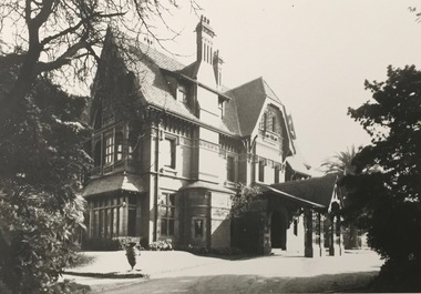
Photograph - 'Tara Hall', Studley Park Road, 1890-1900
During construction, commentators described the house as being in the ‘Elizabethan style’. The architectural style of the exterior, with its innovatory use of red brick and Italian tiles was more influenced by American models. Edward George Kilburn, of Ellerker & Kilburn, designed Byram for the industrialist George Ramsden in 1888.This is an original small photograph of this historic Kew mansion with provenance by descent from the first owners of the house.The main entrance to Tara Hall (previously named Byram, Goathland and Lowan). The entrance, through a porte-cochère, was located on the east side of the house. Inscription reverse: KH-323 Tara Hall once stood on Studley Pk Road on vast landscaped gardens. Donated by Mr Peter Ramsden, 49 Kamilaroy Road, West Pymble 2073 N.S.W. Dec.1979."byram, tara hall, lowan, goathland, edward g. kilburn (architect), george ramsden -
 Kew Historical Society Inc
Photograph, Floods in North Kew, 1971
Living with natural processes was frequently a challenge to early European settlers and later residents of what was in the 1850s administered by the Borondara Road Board. This was compounded by the area being bounded on three sides by rivers (Yarra River, Koonung Creek and Gardiner's Creek). In 1849, the historian James Bonwick recorded that "our district [Kew] suffered considerably. Mr Wade speaks of 80 acres, out of 100 acres of his cultivated paddock, covered by water." Newspapers continued to describe major flooding in Kew in 1863, 1869, 1878, 1880, 1889, 1891, 1916 and 1934. While the construction of the Upper Yarra dam in 1957 reduced the levels of flowing downstream, local and riverine floods continue.The Kew Historical Society's pictures and map collections testify to the impact of flooding in the district. They have historical importance in documenting the extent of flooding in the district and its affects on homes, services and recreation. Numerous photographs record flooding throughout the Twentieth Century.Floods in North Kew, 1971. Looking northeast towards Kilby Road from River Avenue. Annotation on reverse: map and date "8 Nov. 71 10.30am".floods (kew), yarra river, kew flood, kilby road flood -
 Kew Historical Society Inc
Photograph, Floods in North Kew, 1934
Living with natural processes was frequently a challenge to early European settlers and later residents of what was in the 1850s administered by the Borondara Road Board. This was compounded by the area being bounded on three sides by rivers (Yarra River, Koonung Creek and Gardiner's Creek). In 1849, the historian James Bonwick recorded that "our district [Kew] suffered considerably. Mr Wade speaks of 80 acres, out of 100 acres of his cultivated paddock, covered by water." Newspapers continued to describe major flooding in Kew in 1863, 1869, 1878, 1880, 1889, 1891, 1916 and 1934. While the construction of the Upper Yarra dam in 1957 reduced the levels of flowing downstream, local and riverine floods continue.The Kew Historical Society's pictures and map collections testify to the impact of flooding in the district. They have historical importance in documenting the extent of flooding in the district and its affects on homes, services and recreation. Numerous photographs record flooding throughout the Twentieth Century.Floods in North Kew, 1934. Vicinity of Willsmere Park.floods (kew) -
![Flooding at Chipperfield's Boathouse [East Kew], 1934](/media/collectors/550653872162f11fb04854aa/items/58cbaad5d0cec425b474bfb1/item-media/58cf6fbdd0cf9f331490feb0/item-fit-380x285.jpg) Kew Historical Society Inc
Kew Historical Society IncPhotograph, Flooding at Chipperfield's Boathouse, 1934
Living with natural processes was frequently a challenge to early European settlers and later residents of what was in the 1850s administered by the Borondara Road Board. This was compounded by the area being bounded on three sides by rivers (Yarra River, Koonung Creek and Gardiner's Creek). In 1849, the historian James Bonwick recorded that "our district [Kew] suffered considerably. Mr Wade speaks of 80 acres, out of 100 acres of his cultivated paddock, covered by water." Newspapers continued to describe major flooding in Kew in 1863, 1869, 1878, 1880, 1889, 1891, 1916 and 1934. While the construction of the Upper Yarra dam in 1957 reduced the levels of flowing downstream, local and riverine floods continue.The Kew Historical Society's pictures and map collections testify to the impact of flooding in the district. They have historical importance in documenting the extent of flooding in the district and its affects on homes, services and recreation. Numerous photographs record flooding throughout the Twentieth Century.Floods in North Kew, 1934. Chipperfield's Boathouse and the adding Moorings was located beside the Yarra River near the corner of Willsmere and Kilby Roads. The flood reached the roof of the Moorings, which can be seen in the photo.floods (kew), floods (kew) 1934, yarra river -
 Kew Historical Society Inc
Photograph, Floods in North Kew, 1934
Living with natural processes was frequently a challenge to early European settlers and later residents of what was in the 1850s administered by the Borondara Road Board. This was compounded by the area being bounded on three sides by rivers (Yarra River, Koonung Creek and Gardiner's Creek). In 1849, the historian James Bonwick recorded that "our district [Kew] suffered considerably. Mr Wade speaks of 80 acres, out of 100 acres of his cultivated paddock, covered by water." Newspapers continued to describe major flooding in Kew in 1863, 1869, 1878, 1880, 1889, 1891, 1916 and 1934. While the construction of the Upper Yarra dam in 1957 reduced the levels of flowing downstream, local and riverine floods continue.The Kew Historical Society's pictures and map collections testify to the impact of flooding in the district. They have historical importance in documenting the extent of flooding in the district and its affects on homes, services and recreation. Numerous photographs record flooding throughout the Twentieth Century.Floods in North Kew, 1934. Unidentified location on the Yarra Flood Plain at Kew.floods (kew) 1934, yarra river -
 Kew Historical Society Inc
Photograph, Floods in North Kew, 1934
Living with natural processes was frequently a challenge to early European settlers and later residents of what was in the 1850s administered by the Borondara Road Board. This was compounded by the area being bounded on three sides by rivers (Yarra River, Koonung Creek and Gardiner's Creek). In 1849, the historian James Bonwick recorded that "our district [Kew] suffered considerably. Mr Wade speaks of 80 acres, out of 100 acres of his cultivated paddock, covered by water." Newspapers continued to describe major flooding in Kew in 1863, 1869, 1878, 1880, 1889, 1891, 1916 and 1934. While the construction of the Upper Yarra dam in 1957 reduced the levels of flowing downstream, local and riverine floods continue.The Kew Historical Society's pictures and map collections testify to the impact of flooding in the district. They have historical importance in documenting the extent of flooding in the district and its affects on homes, services and recreation. Numerous photographs record flooding throughout the Twentieth Century.Floods in North Kew, 1934. Chipperfield's Boat House under flood.floods (kew) 1934, yarra river, chipperfield's boat house -
 Kew Historical Society Inc
Photograph, Floods in North Kew, 1934
Living with natural processes was frequently a challenge to early European settlers and later residents of what was in the 1850s administered by the Borondara Road Board. This was compounded by the area being bounded on three sides by rivers (Yarra River, Koonung Creek and Gardiner's Creek). In 1849, the historian James Bonwick recorded that "our district [Kew] suffered considerably. Mr Wade speaks of 80 acres, out of 100 acres of his cultivated paddock, covered by water." Newspapers continued to describe major flooding in Kew in 1863, 1869, 1878, 1880, 1889, 1891, 1916 and 1934. While the construction of the Upper Yarra dam in 1957 reduced the levels of flowing downstream, local and riverine floods continue.The Kew Historical Society's pictures and map collections testify to the impact of flooding in the district. They have historical importance in documenting the extent of flooding in the district and its affects on homes, services and recreation. Numerous photographs record flooding throughout the Twentieth Century.Floods in North Kew, 1934. Flood near the lagoon (Billabong?)floods (kew) 1934, yarra river -
 Kew Historical Society Inc
Photograph, Chipperfield's Boat House & Floating Pontoon, 1934
Living with natural processes was frequently a challenge to early European settlers and later residents of what was in the 1850s administered by the Borondara Road Board. This was compounded by the area being bounded on three sides by rivers (Yarra River, Koonung Creek and Gardiner's Creek). In 1849, the historian James Bonwick recorded that "our district [Kew] suffered considerably. Mr Wade speaks of 80 acres, out of 100 acres of his cultivated paddock, covered by water." Newspapers continued to describe major flooding in Kew in 1863, 1869, 1878, 1880, 1889, 1891, 1916 and 1934. While the construction of the Upper Yarra dam in 1957 reduced the levels of flowing downstream, local and riverine floods continue. A number of boat houses operated on both sides of the River Yarra at Kew. Chipperfield's Boat House was located on the Yarra near the corner of Kilby and Willsmere Roads.The Kew Historical Society's pictures and map collections testify to the impact of flooding in the district. They have historical importance in documenting the extent of flooding in the district and its affects on homes, services and recreation. Numerous photographs record flooding throughout the Twentieth Century.Floating pontoon at Chipperfield's Boat House where the canoes were stored, taken in 1934, presumably before the 1934 Flood. This area of the Yarra was shallow with a number of mid river sandbanks and a popular swimming area for locals.yarra river, chipperfield's boathouse, pontoon -
 Freemasons Victoria - Gordon Lodge, 99
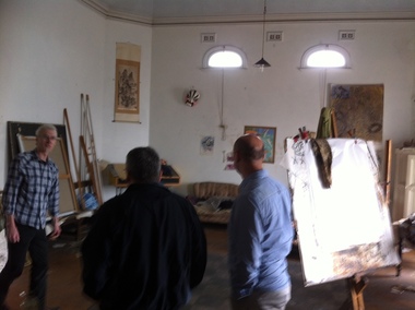
Original Gordon Lodge lodge-room 1886
A picture of the original Gordon Lodge lodge-room of 1886 - room currently in use by the Lodge's artist-in-residence. Below is a newspaper article from the North Melbourne Advertiser (Vic: 1873 - 1894) for Friday 22 April 1887 that describes the architecture of the building at the time of its completion. From some of the details included in the article it is obvious that the journalist who wrote the article was a Freemason. THE MASONIC HALL ASCOT VALE North Melbourne Advertiser (Vic. : 1873 - 1894) Friday 22 April 1887 THE MASONIC HALL ASCOT VALE The now Masonic Hall, Ascot Vale, the foundation stone of which was laid by the Worshipful Master of the Gordon Lodge (Bro, W. F. Lamonby) in October last has just been completed, and will be formally opened: with grand Masonic ball on the 13th prox. The hall stands on a fine block of land having a frontage of 50ft to the Maribyrnong road by a depth of 130 ft., and is built of brick and cement on a most substantial foundation of bluestone. The Tuscan style of architecture has been adopted with the most successful result, and the front design which is especially handsome, includes four massive pilasters with frieze architrave and enriched cornice, forming the entablature of the order,- and giving a most imposing appearance. The front door, over which are the masonic emblems, is seven feet wide, and two escape doors made to open outwards in compliance with the Central Board of Health regulations are also provided, in case of emergency. In the vestibule is a very fine elliptic arch with keystone enriched with fruit, and the whole floor, 9ft. 6in. wide, is laid with Cawkwell's encaustic tyles. On the right, of tile vestibule is a commodious committee room 22ft. by 12ft 6in with side entrance for members, so that in case the main hall is engaged no inconvenience need be caused. On the left is the Secretary's room, and off this again is a staircase cellar. The vestibule is well lighted with two exceedingly pretty chandeliers, which have a very pleasing effect and give it a nice bright appearance ascending a handsome staircase leading from the vestibule the upper storey is reached, and here everything is splendidly arranged, especially 'the Lodge Room, which is a model of neatness and of comfort. The dimensions are 28ft. x 22ft 6in. with an elevation of 17ft. 6in. to the beautiful cove ceiling, which is quite a work of art. At the east end of the room on a raised dais is the master's chair with the masonic emblems, and neat forms of polished kauri are placed at the sides for members, about 150 of whom can be accommodated. The lighting and ventilation have both been well attended to and all is very complete. The main hall is 75ft. by 35 ft. with a stage 15ft. deep, leaving the auditorium 60ft. x 35ft. with a seating capacity about 600. Round the walls up to 6ft 6in. is a handsome dado in Portland cement and above it are panelled Tuscan pilasters to the entablature, architrave enriched frieze and medallion cornice forming the main cornice to the hall. Immediately inside the cornice is a sunken panel all-round the ceiling relieved with ornamental outlet ventilators. There are twelve large windows, six on each aide, and the sashes, skirting boards, and doors throughout the building are beautifully painted in imitation of grained cedar. Two enormous gas reflectors, each for 50 lights are suspended from the ceiling and besides these, four elegant hanging chandeliers for lighting up the proscenium, and back of the stage, under which is a storeroom for seats, &c, when the hall is required for a ball. The floor is made of kauri, secretly nailed, and is beautifully finished off. At the back of the stage are two lavatories and ladies and gentlemen's dressing rooms, between which are a connecting passage for a call boy. Outside is a capital asphalted yard, and the other usual conveniences on an improved plan. There is a right-of-way asphalted on each side of the building, and a large lamp is to be placed opposite the main entrance to light up the front. Everything that forethought and ability could suggest to make the hall comfortable and popular has been done, and it now only remains for the public to avail themselves of the advantages offered them by the enterprising Company. The cost of the building and furniture, including a magnificent piano, was £2,500, and the land £300. Mr J. C. M. Cowan, of Ascot Vale, is the architect, and Messrs Parker and Pater, of South Melbourne, the contractors. The plastering was done by Mr I Nicholas, of Murray Street, Moonee Ponds, who is also entitled to great praise for his splendid workmanship. Mr Cowan has been most assiduous and particular in seeing that his instructions were carried out to his satisfaction, and the result must be exceedingly gratifying to him and to the directors. The Masonic hall is only one of the many buildings erected by Mr Cowan in this district, among the others being the well known residences of Meessrs. J. Levy, Mooneo Street; W. Murphy, Eglington street; G. Groube, Maribyrnong street; C. A. Arvier, Moonee Ponds ; and F. Paul, Mount Alexander road. It may also be mentioned that Mr Cowan generously presented the plans for the now local fire brigade tower which is acknowledged to be one of the strongest and most graceful around Melbourne, The new Masonic Hall does infinite credit to the borough, and in accommodation, design, and comfort it is not surpassed by any similar building of the kind outside the city. -
 Kew Historical Society Inc
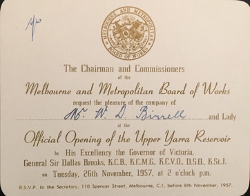
Document (item) - Invitation to the Official Opening of the Upper Yarra Reservoir, Melbourne and Metropolitan Board of Works, 1957
... Single-sided invitation to the Mr W D Birrell to attend... OF THE COMPANY OF / Mr W D Birrell / AT THE / OPENING OF THE UPPER YARRA ...The Municipality of Kew (1860-1863), the Borough of Kew (1863-1910), the Town of Kew (1910-1921) and the City of Kew (1921-1994) were local government instrumentalities in the State of Victoria. In 1994, the City of Kew was amalgamated, together with the former Cities of Camberwell and Hawthorn, into the new City of Boroondara (1994- ). Like other local government entities of the period, Kew was administered by town clerks. The two notable town clerks in Kew's history were H. H. (Henry Hirst) Harrison (1868-1955) and W. D. (William Dickie) Birrell (1899-1974). Harrison was appointed to the position in 1901 and retired in 1938 after 37 years. Birrell, appointed Acting Town Clerk in 1921, became Town Clerk in 1938, following Harrison's retirement. He continued in this role until his retirement in 1966.This card is part of an historically significant civic collection, containing hundreds of separate invitations, documents, greeting cards, programmes and tickets issued and/or collected by successive town clerks. Items in the collection illuminate the political, social and cultural history of the district. As a continuous record, ranging across most decades of the Twentieth Century, they reveal changing tastes in design, values and relationships in the history of local government in Victoria.THE CHAIRMEN AND COMMISSIONERS / OF THE MELBOURNE AND METROPOLITAN BOARD OF WORKS / REQUEST THE / PLEASURE OF THE COMPANY OF / Mr W D Birrell / AT THE / OPENING OF THE UPPER YARRA RESERVOIR / BY HIS EXCELLENCY THE GOVERNOR OF VICTORIA / GENERAL SIR DALLAS BROOKS KCB KCMG KCVO DSO KStJ / ON TUESDAY, 26TH NOVEMBER, 1957, AT 2 O'CLOCK P.M. / RSVP TO THE SECRETARY, 110 SPENCER STREET, MELBOURNE, C1, BEFORE 8TH NOVEMBER, 1957civic invitations -- kew (vic), melbourne & metropolitan board of works, upper yarra reservoir -
 Kew Historical Society Inc
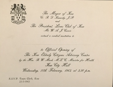
Document (item) - Invitation, City of Kew, Official Opening of the Kew Elderly Citizens' Advisory Centre, 1963
The Municipality of Kew (1860-1863), the Borough of Kew (1863-1910), the Town of Kew (1910-1921) and the City of Kew (1921-1994) were local government instrumentalities in the State of Victoria. In 1994, the City of Kew was amalgamated, together with the former Cities of Camberwell and Hawthorn, into the new City of Boroondara (1994- ). Like other local government entities of the period, Kew was administered by town clerks. The two notable town clerks in Kew's history were H. H. (Henry Hirst) Harrison (1868-1955) and W. D. (William Dickie) Birrell (1899-1974). Harrison was appointed to the position in 1901 and retired in 1938 after 37 years. Birrell, appointed Acting Town Clerk in 1921, became Town Clerk in 1938, following Harrison's retirement. He continued in this role until his retirement in 1966.This card is part of an historically significant civic collection, containing hundreds of separate invitations, documents, greeting cards, programmes and tickets issued and/or collected by successive town clerks. Items in the collection illuminate the political, social and cultural history of the district. As a continuous record, ranging across most decades of the Twentieth Century, they reveal changing tastes in design, values and relationships in the history of local government in Victoria.THE MAYOR OF KEW CR R D KENNEDY JP / AND / THE PRESIDENT, LIONS CLUB OF KEW, MR W A J CURRIE / EXTEND A CORDIAL INVITATION TO / ___________________ / TO OFFICIAL OPENING OF THE KEW ELDERLY CITIZENS ADVISORY CENTRE / BY THE HON R W MACK MLC MINISTER OF HEALTH / KEW CITY HALL / WEDNESDAY, 27TH FEBRUARY, 1963, AT 3.30 P.M. / RSVP TOWN CLERK, KEW 22-2-1963civic invitations -- kew (vic), kew elderly citizens association, cr r d kennedy -
 Kew Historical Society Inc
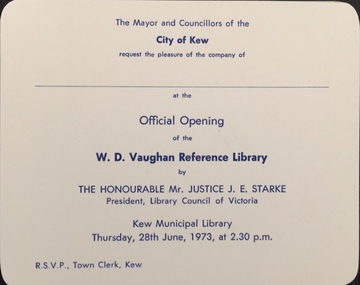
Document (item) - Invitation, City of Kew, Official Opening of the W D Vaughan Reference Library, 1973
The Municipality of Kew (1860-1863), the Borough of Kew (1863-1910), the Town of Kew (1910-1921) and the City of Kew (1921-1994) were local government instrumentalities in the State of Victoria. In 1994, the City of Kew was amalgamated, together with the former Cities of Camberwell and Hawthorn, into the new City of Boroondara (1994- ). Like other local government entities of the period, Kew was administered by town clerks. The two notable town clerks in Kew's history were H. H. (Henry Hirst) Harrison (1868-1955) and W. D. (William Dickie) Birrell (1899-1974). Harrison was appointed to the position in 1901 and retired in 1938 after 37 years. Birrell, appointed Acting Town Clerk in 1921, became Town Clerk in 1938, following Harrison's retirement. He continued in this role until his retirement in 1966.This card is part of an historically significant civic collection, containing hundreds of separate invitations, documents, greeting cards, programmes and tickets issued and/or collected by successive town clerks. Items in the collection illuminate the political, social and cultural history of the district. As a continuous record, ranging across most decades of the Twentieth Century, they reveal changing tastes in design, values and relationships in the history of local government in Victoria.THE MAYOR AND COUNCILLORS OF THE CITY OF KEW / REQUEST THE PLEASURE OF THE COMPANY OF / ________________________ / AT THE OFFICIAL OPENING OF THE W D VAUGHAN REFERENCE LIBRARY / BY / THE HONOURABLE MR JUSTICE J E. STARKE / PRESIDENT LIBRARY COUNCIL OF VICTORIA / KEW MUNICIPAL LIBRARY / THURSDAY 28TH JUNE, 1973, AT 2.30 P.M. / RSVP TOWN CLERK, KEWcivic invitations -- kew (vic), kew municipal library, w d vaughan -
 Kew Historical Society Inc
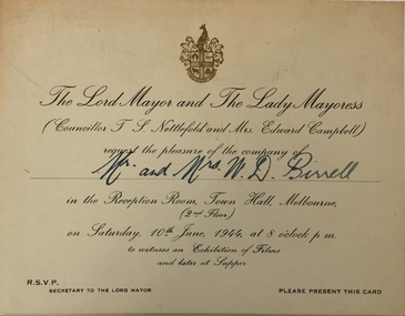
Document (item) - Invitation, City of Melbourne, Exhibition of Films, 1944
... Single sided Invitation to Mr and Mrs W D Birrell... invitations Single sided Invitation to Mr and Mrs W D Birrell ...The Municipality of Kew (1860-1863), the Borough of Kew (1863-1910), the Town of Kew (1910-1921) and the City of Kew (1921-1994) were local government instrumentalities in the State of Victoria. In 1994, the City of Kew was amalgamated, together with the former Cities of Camberwell and Hawthorn, into the new City of Boroondara (1994- ). Like other local government entities of the period, Kew was administered by town clerks. The two notable town clerks in Kew's history were H. H. (Henry Hirst) Harrison (1868-1955) and W. D. (William Dickie) Birrell (1899-1974). Harrison was appointed to the position in 1901 and retired in 1938 after 37 years. Birrell, appointed Acting Town Clerk in 1921, became Town Clerk in 1938, following Harrison's retirement. He continued in this role until his retirement in 1966.This card is part of an historically significant civic collection, containing hundreds of separate invitations, documents, greeting cards, programmes and tickets issued and/or collected by successive town clerks. Items in the collection illuminate the political, social and cultural history of the district. As a continuous record, ranging across most decades of the Twentieth Century, they reveal changing tastes in design, values and relationships in the history of local government in Victoria.w d birrell, cr t s nettlefold, city of melbourne -- invitations, civic invitations -
 Kew Historical Society Inc
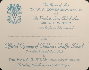
Document (item) - Invitation, City of Kew, Official Opening of Children's Traffic School, 1957
The Municipality of Kew (1860-1863), the Borough of Kew (1863-1910), the Town of Kew (1910-1921) and the City of Kew (1921-1994) were local government instrumentalities in the State of Victoria. In 1994, the City of Kew was amalgamated, together with the former Cities of Camberwell and Hawthorn, into the new City of Boroondara (1994- ). Like other local government entities of the period, Kew was administered by town clerks. The two notable town clerks in Kew's history were H. H. (Henry Hirst) Harrison (1868-1955) and W. D. (William Dickie) Birrell (1899-1974). Harrison was appointed to the position in 1901 and retired in 1938 after 37 years. Birrell, appointed Acting Town Clerk in 1921, became Town Clerk in 1938, following Harrison's retirement. He continued in this role until his retirement in 1966.This card is part of an historically significant civic collection, containing hundreds of separate invitations, documents, greeting cards, programmes and tickets issued and/or collected by successive town clerks. Items in the collection illuminate the political, social and cultural history of the district. As a continuous record, ranging across most decades of the Twentieth Century, they reveal changing tastes in design, values and relationships in the history of local government in Victoria.THE MAYOR OF KEW / CR W A COMEADOW OBE JP / AND THE PRESIDENT, LIONS CLUB OF KEW / MR A L WINTER / REQUEST THE PLEASURE OF THE COMPANY OF / _______________ / AT THE / OFFICIAL OPENING OF THE CHILDREN'S TRAFFIC SCHOOL / CR COTHAM ROAD AND GRANGE ROAD / BY / THE HON A G RYLAH MLA, DEPUTY PREMIER / SATURDAY 15TH JUNE, 1957, AT 2.30 P.M.civic invitations -- kew (vic), children's traffic school -- kew (vic.) -
 Kew Historical Society Inc
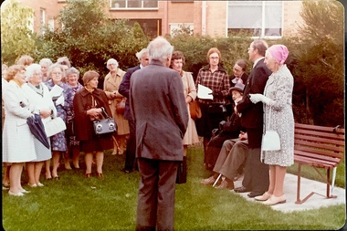
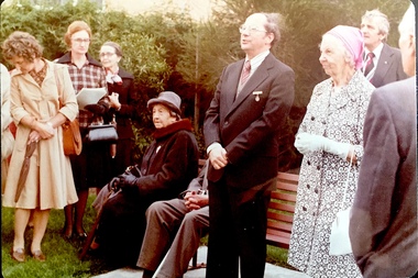
Photograph - Opening of the Dorothy Rogers Reserve, 1976
Dorothy Rogers wrote two major books on Kew's history: Lovely Old Homes of Kew (1961) and A History of Kew (1973). In addition to her published works, she was a regular contributor on issues of local history to suburban newspapers. Her archives are held in the collections of the State Library of Victoria and Kew Historical Society. Three years after her death in 1973, the Reserve was opened in her honour.Faded colour positive photograph of the opening of the Dorothy Rogers Reserve in 1976. The naming of the reserve honoured the contribution of the historian Dorothy Rogers, foundation member of the Society. The reserve is located on the north side of Studley Park Road just west of Kew Junction. Inscribed verso: "Members and relatives of the late Dorothy Rogers. Memorial reserve named and unveiled in her honour by (Cr Whiting Mayor) and City Manager Mr Fell 1978. In respect for her great research and service to the history of early Kew, and other places."dorothy rogers reserve, public parks -- kew (vic.) -
 Kew Historical Society Inc
Photograph - Opening of the Dorothy Rogers Reserve, 1976
Dorothy Rogers wrote two major books on Kew's history: Lovely Old Homes of Kew (1961) and A History of Kew (1973). In addition to her published works, she was a regular contributor on issues of local history to suburban newspapers. Her archives are held in the collections of the State Library of Victoria and Kew Historical Society. Three years after her death in 1973, the Reserve was opened in her honour.Faded colour positive photograph of the opening of the Dorothy Rogers Reserve in 1976. The naming of the reserve honoured the contribution of the historian Dorothy Rogers, foundation member of the Society. The reserve is located on the north side of Studley Park Road just west of Kew Junction. Inscribed verso: "Left to right: Mrs Rogers Jnr, Joy Stewart, Miss Jenkins sitting / Mrs Richardson and Mr Richardson, Brother of D. Rogers), Mayor Cr Whiting, City Manager Mr Fell, Background / KHS President Miss Hall, Mr B O'Neill KHS member, / taken during the memorial unveiling of the Dorothy Rogers Reserve"dorothy rogers reserve, public parks -- kew (vic.) -
![Photograph - c. 1900s, [Illegible], Rock of Ages in Statuary and Song, c.1900s](/media/collectors/5423a8ba2162f1155cc09d2a/items/542cca6a2162f1124caadfb6/item-media/542cccd72162f1124caaf841/item-fit-380x285.jpg) Expression Australia
Expression AustraliaPhotograph - c. 1900s, [Illegible], Rock of Ages in Statuary and Song, c.1900s
Deaf women dressed in white flowing robes were typically used by the Society at meetings and lectures giving a performance in living statuary. This photograph is a depiction from Rock of Ages in Statuary and Song described in a review by the Spectator - the words of the hymn softly sung by the Cornish Choir to an exquisitely delicate organ accompaniment by Mr E. J. Watkins. The Grouping of Living Statuary with the limelight thrown upon them from either side, motionless as marble figures, but with the life and love and adoration in their eyes and on their faces, formed the most beautiful objects we have ever beheld. The Audience looked and listened in breathless silence and many eyes were glistening with tears.This photo is significant as a studio photograph of Deaf women who performed 'living statuar'y at many of the lectures and meetings held in the early years of the 20th century by the Adult Deaf and Dumb Society of Victoria ; possibly introduced by Ernest Abraham to add drama to the occasion.A5 black and white photograph on a cardboard frame. The photograph features five women in robes surrounding a cross."City Chambers / 114 Elizabeth Street / Melbourne" Signature of photographer or studio name illegible. -
 8th/13th Victorian Mounted Rifles Regimental Collection
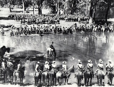
Photograph
A rare photograph of massed Light Horse in Victoria shortly before mechanisation consigned the horse to history.Black and white photograph of large group of horsemen in ranks waiting in the process of watering horses at a lagoon. One copy of the image claims it to be 8th Light Horse Regiment watering horses at a Murray River lagoon, South Corowa NSW, September 1939; Wahgunyah Troop, C Squadron - this side of lagoon, Lieutenant J. Nott on grey horse in water. A second copy (Cat No 0690) asserts it is 4 regiments of light horse being 8th, 13th, 20th and 4th watering horses near Torquay Victoria, March 1940.On a label on reverse of 0690: "Picture taken about March 1940 when the 13th Light Horse from Gippsland, the 8th Light Horse from Upper Murray, the 4th Light Horse from the Western Districts and the 20th Light Horse from the Goulburn Valley were in camp near Torquay. Mr Cappur Webb of Glendoxey, Seymour, a member of the 20th said the picture must have been taken during and exercise about five miles north of Torquay. “We used to water our horses in that lake”, he said."