Showing 993 items
matching paddocks
-
 Linton and District Historical Society Inc
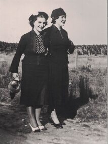
Photograph, Kitty Jennings and Joyce Chung
Kitty (Catherine) Sandow and Joyce Rowe grew up in Linton and attended Linton State School. Kitty Sandow (1916-1984) married Reg Jennings in 1946. Joyce Rowe (1912-1997) married Mick (Martin) Chung in 1931. Kitty and Reg took over the management of Kitty's parent's grocery and confectionery shop, which then became known as "Jennings' Milk Bar". Joyce, a descendant of the Nicol family, worked at Nicol's bakery. Her husband Mick Chung worked for the railways.Enlarged black and white copy of original photograph which has been mounted on card. The photograph shows two women, both wearing dark coloured jackets and skirts, hats and dress-shoes. The woman on the left is carrying a handbag, while the woman on the right has a handbag tucked under her arm. They are standing on a roadway or track, and a wire fence and paddock can be seen in the background. Kitty Jennings (née Sandow) and her friend Joyce Chung (née Rowe). The photograph is undated.joyce chung (née rowe), kitty jennings (née sandow) -
 Bacchus Marsh & District Historical Society
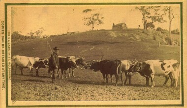
Photograph, Bullocks in paddock, near Bacchus Marsh 1883
Transportation of goods and material by bullock teams was a common feature of life in nineteenth century Australia. Bullock teams could comprise more than twenty bullocks to haul very large and heavy loads. They were the equivalent of large trucks on the roads of today. Many Australian country towns have very wide main streets to allow for large bullock teams to turn without having to unharness and reharness the animals. The bullock driver in this photo is thought to be of James Densley, aka Charlie (the ) Carter, who lived at Hopetoun, east of the township of Bacchus Marsh. He worked as a carrier with a bullock team in the later years of the nineteenth century. He had a reputation as a sober man who never used bad language. (Williams, W. A History of Bacchus Marsh and its Pioneers. 1836-1936. Reproduced 2015 BMDHS.p. 78.) James Densley died in 1905, supposed to be over the age of ninety.Small sepia unframed photograph on card with gold border framing photograph. Housed in the album, 'Photographs of Bacchus Marsh and District in 1883 by Stevenson and McNicoll'. The image shows a group of seven shorthorn bullocks in a paddock. Their yokes and a chain can be seen. Standing near them is a bearded man holding a bullock team leader's whip. He is dressed neatly and is wearing a very smart hat. On the hilltop stands a large hut, possibly with a bark shingle roof. A chimney is at the end of the dwelling. On the front: Stevenson & McNicoll. Photo. 108 Elizabeth St. Melbourne. COPIES CAN BE OBTAINED AT ANY TIME. On the back: LIGHT & TRUTH inscribed on a banner surmounted by a representation of the rising sun. Copies of this Portrait can be had at any time by sending the Name and Post Office Money Order or Stamps for the amount of order to STEVENSON & McNICOLL LATE BENSON & STEVENSON, Photographers. 108 Elizabeth Street, MELBOURNE. stevenson and mcnicoll 1883 photographs of bacchus marsh and district, bullocks, bullock teams -
 Kiewa Valley Historical Society
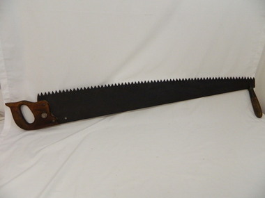
Saw Logging, circa early 1900's
This item can be seen as a hand piece belonging to a logger or farmer spanning over one hundred or more years. The equipment was made to perfection as a hand tool and has not been improved upon since its introduction into the logging industry or farming fraternity. It can be used by one person or two (husband and wife or father and child). Its versatility is ageless. It can be used for domestic clearing of the paddocks, or for domestic fire places and stoves or commercial logging up until the 2000s (introduction of specific logging trucks that cut and treat the trees in one process).This item is very significant to the rural and logging regions within the Kiewa Valley. It has been used for domestic wood cutting and for industrial logging in the mid to late 1900s. It was used when clearing land for the SEC Hydro scheme and to allow for the introduction of the Mount Beauty construction workers' village (later developed into the town) The great advantage of this saw was that it uses only muscle power and can be located where ever a lumber "Jack" or property owner can venture. either by foot or by horse.This saw is a Warranted Superior One/Two Man Logging Saw. It has 68 teeth and is 42 inches long. At a position of one inch (2.5cm) from the end is a hole one inch down from the leading edge. There is another hole 45 cm in front of the handle. Both these holes are for a "helper handle" which when in use renders this logging saw fit for a two man operation. This is a cross cut saw for cutting down vertical trees (horizontal cut) The handle is made from wood and fastened to the blade by three heavy duty screws. The one helper handle stands 150mm high and has a 150mm wooden hand grip.The central screw has 25mm manufacturers' identification logo stamped "WARRANTED SUPERIOR".one or two man cross cut saws, forestry, timber industry -
 Tatura Irrigation & Wartime Camps Museum
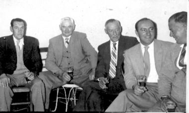
Photograph, Coursing and Racing Club
Greyhound Coursing was popular as far back as 1886, when the first president of the club was Mr Gellion. From 1896, open coursing was held at Dhurringile Estate until 1904, when meetings were held "in the paddock north of the town" In 1919 the Tatura Plumpton Coursing Club was inaugurated and successfully ran many of the classics, such as the Oaks, Derby, and Waterloo Cup meetings until 1967, when Plumpton Coursing was declared illegal. Plumpton Coursing Club: L-R: Neil Colliver, Mick O'Reilly, Jack Maher, John Marker, Tom Cornish.Black and white photograph of members of the Plumpton Coursing Club. Photograph on foam backing.Plumpton Coursing Club - list of members (see below). approximately 1950's.tatura, recreations, sports -
 Stawell Historical Society Inc
Photograph, "Ashen" Homestead Remnants in Murtoa after a Storm c1920’s
Dugald McPherson's Ashen's Homestead (Remnants) c1920’s Ashen's south of Murtoa was one of the area's original squatting runs. This photo taken in the 1920's shows the homestead after a violent storm had been through the area. In 1853, the country around Ashen's was covered by timber, she-oaks, bull-oaks, light gum and box thickets of ti-tree and clumps of pine and wattles. The vegetation was so thick outside the horse paddock it was difficult to move in any direction. It was said McPherson and two others fought over the land.Back entrance to Ashen's Station.stawell -
 Surrey Hills Historical Society Collection
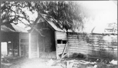
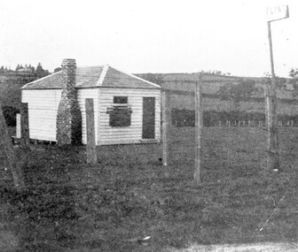
Photograph, The gate-keeper's shed, Surrey Hills Golf Club
Reproduced by permission of Mr John Arnold from his book: "The Riversdale Golf Club - a history, 1892-1977." Copyright to book: Riversdale Golf Club. Surrey Hills Golf Club operated from 1892-1908 then moved and became Riversdale Golf Club. The game was played across paddocks from Trafalgar Street, Mont Albert to Whitehorse Road and down Victoria Crescent to where Box Hill TAFE is now located in Elgar Road. There were problems with cows eating the tee flags! The clubhouse still exists as 30 Trafalgar Street.Apart from it association with the Surrey Hills Golf Club which is long gone, this image documents the landscape of pre-urban Surrey Hills.Black and white photo of a rectangular timber building with a slate hip roof and brick chimney on the LHS. The one visible window appears to be boarded up and has a door to its right. The building is fenced by posts and wire. A (?) street sign bearing the letters FLINT is at the right of the picture."The gate-keeper's shed was used as a clubhouse from 1895-1900."sports grounds, surrey hills golf club, riversdale golf club, timber building, john arnold -
 Surrey Hills Historical Society Collection
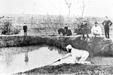
Photograph, Surrey Hills Golf Club water hazard, 1895, 1895
Reproduced by permission of Mr John Arnold from his book: "The Riversdale Golf Club - a history, 1892-1977." Copyright to book: Riversdale Golf Club. Surrey Hills Golf Club operated from 1892-1908 then moved and became Riversdale Golf Club. The game was played across paddocks from Trafalgar Street, Mont Albert to Whitehorse Road and down Victoria Crescent to where Box Hill TAFE is now located in Elgar Road. There were problems with cows eating the tee flags! The clubhouse still exists as 30 Trafalgar Street.Apart from its association in documenting the Surrey Hills Golf Club which has long disappeared, this image documents the landscape in the pre-urban era.Black and white photo of a scene at Surrey Hills Golf Club. There is a water hazard in the foreground with a lady on her knees trying to retrieve a ball from the water's edge. Three lads, one on a horse, are watching, as are 3 males to the right."In water" in the bottom right of the photo. Caption: "Captain Fred Andrew watches his partner's misfortunes during a game at Surrey Hills in 1895."sports grounds, surrey hills golf club, riversdale golf club -
 Surrey Hills Historical Society Collection
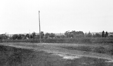
Photograph, Corner of Braemar and Melrose Streets, Box Hill North
Reproduced by permission of Mr John Arnold from his book: "The Riversdale Golf Club - a history, 1892-1977." Copyright to book: Riversdale Golf Club. Surrey Hills Golf Club operated from 1892-1908 then moved and became Riversdale Golf Club. The game was played across paddocks from Trafalgar Street, Mont Albert to Whitehorse Road and down Victoria Crescent to where Box Hill TAFE is now located in Elgar Road. There were problems with cows eating the tee flags! The clubhouse still exists as 30 Trafalgar Street.Black and white panoramic photo taken from the corner of Braemar and Melrose Streets, Box Hill North. There is a large area of ground in the front. A fence and hedge traverse the photo in the middle distance in front of which is a tall light pole. Behind the hedge mature trees and houses can be made out.Caption: "Bottom: The same view today taken from the corner of Braemar and Melrose Streets, Box Hill North, or, from the position of the threesome to the left in the above photograph." + in grey lead pencil in Jocelyn Hall's hand (No 290)sports grounds, surrey hills golf club, riversdale golf club, melrose street, braemar street, surrey hills, john arnold -
 Bacchus Marsh & District Historical Society
Map, Maddingley Township, Parish of Parwan, 1880s
This map is dated Sept. 6th 1856. However places in the township of Maddingley which did not appear until the late 1880s such as the Bacchus Marsh Railway Station and line are shown on this map in their correct locations. This suggests the map has been derived from an earlier map. An earlier date of 1843 with a surveyor's name preceding it can also be seen on the map. The map is important because it indicates the location and dimensions of early but now discontinued use of land such as the showgrounds and police paddock and a site reserved for the Church of England which was not ultimately used for a permanent church. A single page paper map showing land allotments, streets, rivers, creeks, park lands, the railway line and Bacchus Marsh railway station in the township of Maddingley. The map is pasted into a bound volume containing 76 maps or plans in total. Bottom of Map: Surveyor-General's Office, Melbourne, Sept 6th, 1856bacchus marsh victoria maps, maddingley victoria maps, land use, maddingley victoria history -
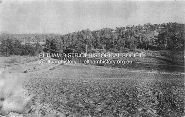 Eltham District Historical Society Inc
Photograph, Trestle Bridge, Eltham, c.1910
Most likely an F-Class 2-4-0 Steam Locomotive pushing carriage about to cross the Eltham Railway Trestle Bridge heading towards Greensborough, viewed from what was later Eltham Common and site of the re-located Shillinglaw Cottage (1964) and Eltham Library (1994). On the far side of the track on what is present day Central Park oval is a crop field. The railway was commenced in 1900 and passed through the middle of the Shillinglaw Farm. Here it passes through the farm paddocks. The train station at Eltham opened in 1902. Colour photocopy of original photo print (on loan?) 25.5 x 39 cm mounted on coreflutePencil mark at bottom "(c) 1910"eltham, trestle bridge, bridges, shillinglaw farm, f-class 2-4-0 steam locomotive, eltham railway trestle bridge, eltham trestle bridge, railway bridge, steam locomotive -
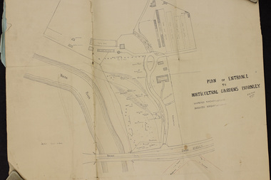 University of Melbourne, Burnley Campus Archives
Plan, Plan of Entrance to Horticultural Gardens Burnley, 1932
Copy of plan photographed at the Public Records Office Victoria. (1) Hand drawn plan signed by A.W. Jessep 8/12/32 with 'Suspected Roadway' and ' Suggested Roadway'. Scale 1 inch - 1 chain. Trees on East side named. (2) Memorandum to The Agricultural Superintendent dated 08.12.1932 'Re Proposed Boulevard Along the River Yarra' from the Principal A.W. Jessep. Plan had been to put road through the Lagoon Paddock and he suggested the route outside the Burnley College grounds.prov, burnley gardens, a.w. jessep -
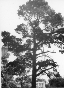 University of Melbourne, Burnley Campus Archives
Photograph - Black and white print, Miscellaneous Photographs
trees, garden views, fruit tree pruning, lagoon paddock, orchard, principals residence, pinus canariensis, sequoia sempervirens, pinus radiata, butia capitata, emily gibson bed -
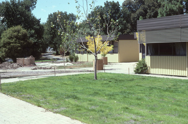 University of Melbourne, Burnley Campus Archives
Album - 35mm Colour slides, Miscellaneous Burnley, 1985
1, 3-8, 15, 20, 22. Quad. Feb 85. 19. Pruning Day 1985 "Barry Dimelow" Jul 85. 18. Apprentice? mowing the Bull Paddock, 2, 11. Administration Building, 14. Nursery, Nov 85. 23, 24.News reporters Dec 85. 27-41. Possible excursion, using a cultivator, not Burnley Nov 85. 10, 13. Garden view. 16. Signing of documents by the Principal? 21. Possibly part of Old Nursery. 43. Sunken garden.pruning day, 1985, barry dimelow, bull paddock, administration building, mowing, publicity, cultivator, quad, nursery, excursion, apprentice, sunken garden -
 City of Kingston
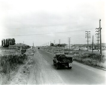
Photograph - Black and white, c. 1957
This image shows the urbanisation of a formerly rural area of Moorabbin.Black and white photograph looking west along South Road. There is a truck in the foreground, travelling along the sealed South Road. A car is waiting to exit from Rowan Road. People are walking along the left hand side of the road, and a young person a bike is riding along the right side. They are all going in the same direction as the traffic. The left hand side of the image shows paddocks in the foreground, which houses further back. The right hand side of the image shows suburban houses with electricity poles running the length of the road. Handwritten in blue ink on reverse: 57-523A Handwritten in red ink on reverse: 85% Handwritten in black ink or grey lead: Ch. 6moorabbin, cars, roads, housing -
 Wodonga & District Historical Society Inc
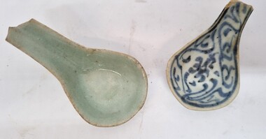
Functional object - Chinese Ceramic Spoons
During the Victorian goldrushes of the 1850s thousands of Chinese migrants arrived to seek their fortunes. At that time many came to the lucrative gold fields of Northeast Victoria. After the Gold rush, many Chinese migrants returned home. However, a number settled in the area as merchants, hawkers and market gardeners in surrounding towns including Wodonga, the Ovens, King, Buffalo River and Kiewa Valleys. They also rented lands and established themselves in the hops and tobacco farming industries. These spoons were found by Mr Robert Black when he was ploughing a paddock on his farm in Kergunyah, Victoria in the 1930s.2 small ceramic Chinese spoons. Spoon 1 has a clear light green glaze. Spoon 2 is decorated with a blue painted pattern.chinese immigration to victoria, chinese market gardens, chinese migration northeast victoria -
 Bacchus Marsh & District Historical Society
Map, O'Hagan v Shire of Bacchus Marsh, Allotment 5, Sec 16, Parish of Korkuperrimul
The purpose for this map being created or the date when it was made has not been established. It appears to be documentation relating to a legal dispute by a landowner named O'Hagan and the Shire of Bacchus Marsh. Features identified on the map are allotment 5, section 16, Parish of Korkuperrimul, a 'cultivation paddock', a section of the Werribee River, the path of a section of a 'Main Channel', and a barrier or filled in section across the Werribee River called 'Lee's Filling'. The O'Hagan is likely to be Patrick O'Hagan, 1829-1914 who arrived in Bacchus Marsh in 1864 and was a prominent citizen and landowner in the area for many years until his death in 1914.Single page map showing allotment 5, section 16 in the Parish of Korkuperrimul, Scale 4 chains to inch. Part of a set of maps which are pasted into a bound volume containing 76 maps or plans in total. High resolution digital image stored on BMDHS computer network. Stamped: Munzt, Bace and Muntz, Civil Engineers and Licensed Surveyors , 388 Collins Streetbacchus marsh victoria maps, water supply structures and establishments, watercourses -
 Mt Dandenong & District Historical Society Inc.
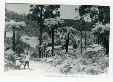
Photograph, View From Doughty's Road 1913
Mt Calvin, the homestead of Jeanie and Willie Richardson can be clearly seen in the clearing above the men in the picture. The white roof of the Barber homestead is on the right of the picture. A landslide in 1934 destroyed the tree ferned area. John Lundy-Clarke grew up in the Kalorama/Mt Dandenong area and later in life (1972-74) began to write a comprehensive history of the area working from an original settlement map in an effort to cover all areas.Black and white photograph that is a copy of a Rose series postcard titled 'The Picturesque Road to Mt. Dandenong. Vic.' It shows two men (probably Rose Series employees), one sitting and one standing at the edge of an unmade road. Large tree ferns line the roadside. Handwritten inscription on reverse by John Lundy-Clarke1913 View east from Doughty’s Road showing Jeannie Richardson’s home through the gap in the trees. A little to the right of and below centre of picture can be seen George Barber’s home with Barbers Road turning around the wagon shed that was a little up the hill from the house. The tree ferns in the picture were destroyed in the landslide of 1934. In the distance at the right can be seen F.M. Childs Homestead complex with the Richardson paddocks beyond it.mt calvin, jeanie richardson, willie richardson, george barber, landslide, tree fern -
 Orbost & District Historical Society
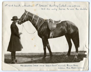
black and white photograph, 1918
Mary Lynch was the daughter of Matthew and Mary (nee Loorham) Lynch. She became Mrs Ivell. she was a noted horse-woman having ridden the Nixon Bros hack, "Gold Dust" at the Melbourne Show coming first in the 10 stone hack and first in the Eagley Hunting Contest. (info. Mary Gilbert) Horse racing was a popular past-time in early Orbost. The Nixon family was involved through Keith Nixon. Some of the earliest horse races were held on a course in a paddock belonging to Mr James Cowell at Jarrahmond. For a long time horse races were part of the Marlo Picnic Races.This item is connected to an activity once popular in the Orbost district. The Nixon family were prominent early settlers in the Orbost district.A black / white photograph of a lady dressed in a a tailored hip coat, bowler hat, knee breeches and boots. She is holding the reins of a saddled horse. There is a copy.on front at top - " 1st 10st hack - 19 entries 1st "EAGLEY" Hunting Contest - 22 entries. Still the only horse to win the double." on front at bottom - " MELBOURNE SHOW 1918 "GOLD DUST" owned by Nixon Bros ridden by Miss MARY LYNCH"lynch-mary nixon-bros-horses equestrian melbourne-show gold-dust -
 Eltham District Historical Society Inc
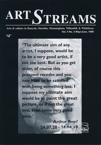
Journal, Peter Doughtery, ArtStreams: Arts & Culture in Banyule, Darebin, Manningham, Nillumbik & Whittlesea; Vol. 4, No. 3, May-Jun 1999, 1999
Vol. 4, No. 3, May-Jun 1999 CONTENTS HEIDELBERG SCHOOL REVISITED Artist's Trail extended 5 FROM JACKEROO TO ARTIST Geoffrey Dance interviewed 8 VCE TOPCATS 10 'ARTIN ABOUT 13 FERGUSON'S PADDOCK, HOME TO CHALLENGING NEW SCULPTURE 15 LA MAMA & THE COMEDY FESTIVAL 17 THE POETRY OF HISTORY The Hanging of Jean Lee 18 MUSEUM OF MODERN ART exhibitions and future plans 34 SHORT STORY High Voltage 22 DINING OUT WITH SIGMUND JORGENSEN 24 CD REVIEWS 26 BOOK REVIEWS 30 CAFE & RESTAURANT LISTINGS 32,33 "Peter Dougherty has been involved in the local art scene for many years. As publisher and editor of the arts magazine Artstreams, his comments on the various branches of the arts are widely respected. His "The Arts" column in the Diamond Valley Leader presents a brief summary for a much wider cross section of the local community. Peter also operates his own gallery and the Artstreams Cafe at the St Andrews market. Peter has a wealth of knowledge about present day and historical aspects of local art and artists." - Eltham District Historical Society Newsletter No. 161, March 2005Colour front and back cover with feature articles and literary pieces with photographs and advertisements printed in black and white. 36 pages, 30 cm. Vol. 1, no. 1 (Nov. 1996) - Vol. 10, no. 5 (summer ed. 2005/06) art streams, arthur boyd, know & grow, heidelberg artists' trail, carlucci's, geoffrey dance, vce art, kasimir burgess, clare james, andrew kelly, jason harris, nichaud fitzgibbon, noella clohesy, willy wonka's ice cream gourmet food, natalie troubnicova, ellen mileo, fergusons paddock, cathy smith, la piazza restaurant bar & cafe, la mama theatre, comedy festival, anne delaney, jordie albiston, dymocks booksellers, dynamic vegies, alison lonsdale, montsalvat, sigmund jorgensen, jacques reymond's restaurant, yarra valley country club, leslie avril, caitlin ogden, geoff achison, neil adam, judy turner, wild hill dog, louis mcmanus, adams of north riding, lovegroves of cottles bridge, artspeak studio gallery, peter sculthorpe, elizabeth scarlett, carmel bird, michelle lonsdale, museum of modern art at heide, st andrews hotel, volumes -
 Eltham District Historical Society Inc
Negative - Photograph, J. P. Lind, Hurst's Bridge, 1885
Looking northwest onto the first bridge at Hurstbridge, 1885. Timber bridge amid rural setting. Two horses graze in an open paddock in the foreground. A house is situated on a rise behind the bridge on a tree lined hill. The area of Hurstbridge was originally known as Hurst’s-bridge after the timber bridge built over the Diamond Creek near Hurst’s station in late 1881/early 1882 on the Hurstbridge-Arthurs Creek Road, Hurstbridge. It was built by John McDonald, of Arthur's Creek and was demolished and replaced in 1917 by a reinforced concrete arch bridge designed by John Monash. Cross Reference Photo No.(s): 1012/1013This photo forms part of a collection of photographs gathered by the Shire of Eltham for their centenary project book, "Pioneers and Painters: 100 years of the Shire of Eltham" by Alan Marshall (1971). The collection of over 500 images is held in partnership between Eltham District Historical Society and Yarra Plenty Regional Library (Eltham Library) and is now formally known as 'The Shire of Eltham Pioneers Photograph Collection.' It is significant in being the first community sourced collection representing the places and people of the Shire's first one hundred years.Digital image 4 x 5 inch B&W Negshire of eltham pioneers photograph collection, hurstbridge, bridge, diamond creek (river), diamond creek (creek), hurst's bridge -
 The Beechworth Burke Museum
Photograph - Carte de Visite
In July of 1880, Ann Jones' successful hotel in Glenrowan burnt to the ground during the Kelly siege. She had opened her business in the year prior having been unsuccessful in her attempt to run a tea-room business in Wangaratta. The first building on this particular site was the home Ann Jones had built for herself and her family. Two years later she converted the home and added the hotel to the rear of the structure. One year later it was burnt to the ground. This image depicts the streetscape of Glenrowan in 1883, three years after the siege. Importantly, it reveals the appearance of several buildings which can reveal information for how Glenrowan (as a small town) might have stood during the siege. These buildings are of typical Australian colonial "miner's cottage" style. On what would have been the site of Ann Jones' hotel, to the far left of the photograph, a police station stands. This police station was built before April 1883. This image was captured by an unknown photographer. This Carte-de-viste (CdV) previously belonged to the donor's grandfather, Daniel Mullins who was a Police Officer stationed at Glenrowan soon after the Kelly gang siege. Today, the siege has become an important part of Australian culture and Ned Kelly and the Kelly Gang (comprising of Ned Kelly, Dan Kelly, Steve Hart and Joe Byrne) has become ingrained in Australian history and mythology. A CdV is a sepia toned photograph mounted on card and is generally of a small size. This particular style was first patented by Andre Adolphe Eugene Disdéri (1819-1889) in 1854. In 1857, the CdV was introduced to England and after photographs of Queen Victoria, Prince Albert and their family were taken using CdV in 1860 the popularity of this method reached a peak.This photograph is part of the Burke Museum "Kelly album" which includes a significant collection of photographs and artefacts connected to Ned Kelly and the Kelly Gang. Ned Kelly and his gang have become ingrained in Australian popular culture and thus many museums, art galleries and private collections house material connected to the Kelly story which allows the events and people to be researched and interpreted. Artefacts and photographs pertaining to the Kelly gang are particularly valuable for Australian museums. This particular photograph is significant for its connection to the Glenrowan Siege and Ann Jones' Hotel which burnt down during the siege in June 1880. Taken in 1883, this photograph (taken by an unidentified photographer) has the opportunity to provide information about the townscape of Glenrowan shortly after the siege. It also provides important insight into the architecture and layout of the town. To the far right of the image, the photograph depicts the police station which was built on the site of Ann Jones' Hotel which can provide important information for the Kelly story and how the town evolved following 1880. It is also interesting to emphasise that the police station was built on the site of Ned Kelly and the Kelly gang's last stand.This photograph is a sepia image of the Glenrowan streetscape depicting several buildings. The newly built police station (in 1883) stands on the far right of the image on the site of the former Ann Jones Hotel. On the left are several buildings built in typical 'miner's cottage' Australian colonial style. This includes the gable roof with the skillion at rear. An unidentifiable individual stands next to the chimney of the front left building. Numerous paddocks appear in the image, particularly in the front right and the rear of the houses contain many trees. To the rear of the image, there is a mountain. A street runs through the centre of the photograph.Glenrowan / taken 1.4.83 ... / BMM 8086kelly album, ned kelly, glenrowan, police history, police, australian architecture, streetscape, glenrowan 1883, 1883, dan kelly, steve hart, joe byrne, carte-de-viste, james bray, daniel mullins, william e barnes, colonial australia, police station, photograph -
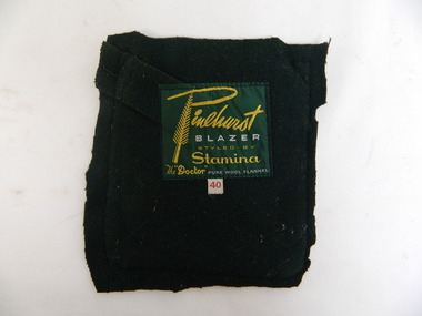 Kiewa Valley Historical Society
School Blazer Pocket Badge
Mt Beauty Higher Elementary School commenced in 1953 as the need for a secondary school grew with the increase in population due to the Kiewa Hydro Scheme. It became the Mt Beauty High School in 1964. The blazer was worn as part of the winter uniform.Historical: Education in Mt Beauty commenced relatively late so there was less of a tradition. The decision to adopt a uniform is of interest to compare with other schools and the times.Pure wool dark green flannel pocket cut out from a Mt Beauty High School blazer. Emblem is machine stitched and has a yellow wattle decoration outside a yellow frame. Across the top of the frame in yellow 'High School", across the bottom of the frame "Mount Beauty", the 2 sides of the frame are hollow. Inside the frame is a stitched picture with a light blue sky, royal blue mountains with white peaks and a white curved path leads towards the mountains with light green 'paddocks' either side. Inscription on back in yellow and white.Pinehurst / Blazer (in white) / Styled by Stamina / The "Doctor" / Pure Wool Flannel (in white) blazer, school, high school, uniform, mt beauty, emblem, education, clothing, winter -
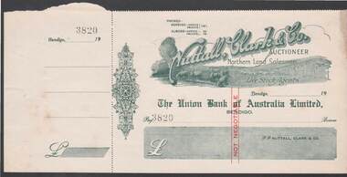 Bendigo Historical Society Inc.
Document - CAMBRIDGE PRESS COLLECTION: CHEQUE - NUTTAL CLARK
Cheque with cheque butt attached. Nuttall, Clark & Co. is printed at an angle across the top. Underneath is Auctioneer, Northern Land Salesmen and Live Stock Agents. Under the name is a rural scene with cattle drinking from a creek , some sheep in a paddock and a two log rail fence. On the other side of the fence are stacks of hay and two men loading the sheaves onto a horse drawn wagon. Date line ends in 19- -. Decorative work on the left side. 3820 stamped after Pay. Printed in a greyish green with red Not Negotiable in the centre.business, printers, cambridge press, cambridge press collection, nuttall clark & co, the union bank of australia limited bendigo -
 Wodonga & District Historical Society Inc
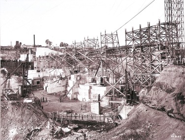
Album - Hume Reservoir Australia Album - Work proceeding inside the coffer dam (2), August 1927
This set of photos is from a leather bound album bearing the inscription "HUME RESERVOIR AUSTRALIA" plus 'The Rt. Hon. L. C. M. S. Amery, P. C., M .P.' all inscribed in gold. It was presented to The Rt. Hon. L. C. M. S. Amery, P. C., M. P, Secretary of State for Dominion Affairs on the occasion of his visit to the Hume Reservoir on 2nd November 1927. This album is of local and national significance as it documents the planning and development of the Hume Reservoir up to 1927. It was the largest water reservoir in the British Empire. The album records the pioneering engineering work that went into its construction.DEPARTMENT OF PUBLIC WORKS, N.S.W. RIVER MURRAY WATERS SCHEME. HUME RESERVOIR. 26. Work proceeding inside the coffer dam. This view was taken from the edge of the cut for the South Wing Wall foundations looking from the opposite direction to that of the preceding photograph, the curving downstream face of the main wall being seen beyond the steam navvy. This view shows the way in which the concrete paddocks are stepped and broken jointed vertically and horizontally. In the distance is the North Wing Wall and Power House stack beyond it. New South Wales, August 1927.hume reservoir australia, river murray waters scheme, hume reservoir construction -
 Bacchus Marsh & District Historical Society
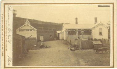
Photograph, Symington Brewery, Hopetoun, near Bacchus Marsh 1883
The family of William Symington arrived in Melbourne in 1855. By 1858 they had come to Bacchus Marsh and built a house at Hopetoun a few kilometres east of the town. A brewery next to the house was also built around this time. It was a licensed brewery between 1862 and 1886. The elder William Symington died in March 1867 and the brewery was then operated by his son the younger William Symington for a number of years. It ceased operations sometime before 1900. Small sepia unframed photograph on card with gold border framing photograph. Housed in the album, 'Photographs of Bacchus Marsh and District in 1883 by Stevenson and McNicoll'. The image shows the brewery and house which belonged to the Symington family of Hopetoun, near Bacchus Marsh. The house is a timber structure with two chimneys and a front verandah. The front yard of the house is enclosed by a timber fence. At the front of the fence can be seen a dog kennel. Other tools, such as a wheelbarrow, lie in the yard. The brewery building is of timber and brick. On the hillside behind the buildings are paddocks fenced with post-and -rail fencing.On the front: Stevenson & McNicoll. Photo. 108 Elizabeth St. Melbourne. COPIES CAN BE OBTAINED AT ANY TIME. On the back: LIGHT & TRUTH inscribed on a banner surmounted by a representation of the rising sun. Copies of this Portrait can be had at any time by sending the Name and Post Office Money Order or Stamps for the amount of order to STEVENSON & McNICOLL LATE BENSON & STEVENSON, Photographers. 108 Elizabeth Street, MELBOURNE. stevenson and mcnicoll 1883 photographs of bacchus marsh and district, breweries, symington family bacchus marsh, william symington 1840-1929, william symington 1802-1867 -
 Eltham District Historical Society Inc
Photograph - Aerial Photograph, Landata, Eltham, Vic, Apr. 1972
Centred on present day Diamond Creek Trail at the Eltham Leisure Centre bounded by Central Park to north, Main Road at Falkiner Street to south, MacMahon Ball Paddock to east and Grand Boulevard at Buena Vista Drive to west. Historic Aerial Imagery Source: Landata.vic.gov.au Aerial Photo Details: Project No :985 Project : MELBOURNE 1972 Run : 28 Frame : 207 Date : 04/1972 Film Type : B/W Camera : RC10 Flying Height : 5700 Scale : 9600 Film Number : 2635 GDA2020 : 37°43'25"S, 145°08'20"E MGA2020 : 335985, 5823223 (55) Melways : 21 G7 (ed. 42)aerial photo, neil webster collection, 1972-04, eltham, buena vista drive, central park, diamond creek trail, eltham leisure centre, falkiner street, grand boulevard, macmahon ball paddock, main road, melway 21g7 -
 Glen Eira Historical Society
Document - GARDENVALE
This file contains two items about Gardenvale, which was previously all part of Caulfield: 1/Photocopied eight page document by M. Stewart, 1961, entitled ‘The Gardenvale Story’. It describes Gardenvale Railway and surrounding roads and land. Lempriere’s Paddock, rail tracks on the main roads for the use of market gardeners’ wagons. Sale of land for O’Neill College Estate and construction of a subway through the railway embankment to Gardenvale Shopping centre, including efforts by local people and the council for work to be completed and costs. Footnote is circa 1977. 2/Map of Glen Eira printed from Council website 20/06/2014 showing Glen Eira’s share of Gardenvale.gardenvale, bent thomas, brighton, caulfield, elsternwick, railway stations, lempriere family, ‘bentville’, lempriere’s paddock, market gardens, nepean highway, nepean road, north road, kooyong road, polo, sheridan family, bluestone houses, bethlehem hospital, land subdivision, begonia street, gardenia road, gardenia street, magnolia street, lantana street, martin street, shops, ‘ben burb’, house names, padua hospital, brighton, o’neill miss, o’neill college, o’neill richard, o’neill estate, elster avenue, o’neill college estate, railway crescent, denver crescent, brentani avenue, college street, rosstown railway, brighton cemetery, ross mr, hawthorn road, ormond, gardenvale progress association, elster creek, parliamentary representatives, landscapes, gardenvale road, railway lines, subways, traders association, drainage, floods -
 Surrey Hills Historical Society Collection
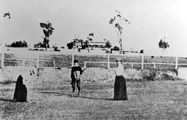
Photograph, Surrey Hills Golf Club eighth hole, 1902, 1902
Reproduced by permission of Mr John Arnold from his book: "The Riversdale Golf Club - a history, 1892-1977." Copyright to book: Riversdale Golf Club. Surrey Hills Golf Club operated from 1892-1908 then moved and became Riversdale Golf Club. The game was played across paddocks from Trafalgar Street, Mont Albert to Whitehorse Road and down Victoria Crescent to where Box Hill TAFE is now located in Elgar Road. There were problems with cows eating the tee flags! The clubhouse still exists as 30 Trafalgar Street. No 3 Beatty Street is in the background. The players are probably standing on what is now Zetland Road.This image is important not only for documentation of early sporting activities in the area but also for evidence of the pre-urban appearance of the landscape.Black and white photo with 2 ladies with golf clubs in the foreground and a lad (? caddy) with a golf bag under his arm. He is wearing a cap and 'plus fours'. The ladies are wearing long skirts, blouses and hats. Behind is a post-and-rail fence with a house and trees in the background.Caption: " Bottom: Putting out on the eighth hole, 1902."sports grounds, surrey hills golf club, riversdale golf club, clothing and dress, zetland road, surrey hills, john arnold -
Eltham District Historical Society Inc
Document - Sharp family
Keith Sharp was a descendant of the Hurst family, and lived in Hurstbridge, being active in the Hurstbridge Country Fire Authority. His family's farm gave its name to Sharps road, Hurstbridge. Contents Gwen Sharp, no date: Photocopy of collection of material on Sharp family of Hurstbridge and naming of Sharps Road containing: Photograph Fergusen's paddock, Hurstbridge, 1987. Notes on renaming of Sharp's Flat to Sharps Road. Notes on the Hurst family and how Keith Sharp is descended from Ellen Hurst, with details of each generation. Photographs of Sharp family and of Hurstbridge. Photograph of Allwood House, 1899, including W G Gray, Carrie Sharp and Robert Sharp. Newspaper clippings, A4 photocopies, etcgwen sharp, sharp's flat hurstbridge, sharps road hurstbridge, arthurs creek, hurstbridge, hurst private memorial grave site, robert hurst, frances hurst, hurst's bridge, ellen hurst, keith sharp, sheila ferguson, henry facey hurst, charles botterell hawkins, fanny hawkins nee hurst, caroline frances maria sharp nee hawkins, robert nehemiah sharp, "the oaks" kinglake, william sharp, edgar sharp, harry sharp, stan sharp, daisy sharp, "homeleigh" hurstbridge, roy sharp, jean sharp, lilian sharp, allwood house hurstbridge, ferguson's paddock hurstbridge, arthur's creek road, carrie sharp, sharps house hurstbridge, dorset house hurstbridge, ryans butcher hurstbdirge, hortons bakery hurstbridge, bootmaker hurstbridge, d g graham blacksmith hurstbridge, noella macperson nee sharp, richard sharp, robert sharp, muriel sharp, edna sharp, lyn sharp, muriel sharp nee limmer, muriel willson, henry willson, country fire authority hurstbridge -
 Tarnagulla History Archive
Photograph of Comrie family in Tarnagulla, Comrie family in Tarnagulla, 31st January 1924
Murray Comrie Collection. The house in this photo was the residence of the town police officer. The town block where the house was located was the base for policing in Tarnagulla from 1878 until the 1990s. At the time of this photo (1924), the father of these children, Angus Comrie Snr was the constable for Tarnagulla. Adjacent to this house was a lockup, office and stable (shown in THA-2019.0031). Behind the residence and outbuildings (in background of this photo) was an adjoining paddock for the police horses. This house was sold for removal in in the 1960s and replaced with a prefabricated residence and small office from Bealiba. These as well as the lockup are still in place (as of 2019), but are no longer used. There are now private residences built on the former police horse paddock. A later image of this house is THA-2019.0032. For almost 100 years the Comrie name has been involved with the Victoria Police. Angus Comrie Snr, joined the force in 1899 and served as constable in Kaniva and Avoca and then in Tarnagulla from late 1909 until 1927. His son Murray Comrie, born in Tarnagulla in 1912 also became a policeman and later a Chief Superintendent, retiring in 1972 and passing away in 1983 after a long illness. Murray Comrie's son Murray Jnr., to avoid confusion became known by his middle name, Neil. Neil Comrie also joined Victoria Police and rose through the ranks to become Chief Commissioner of Victoria Police from 1993 to 2001. The Murray Comrie Collection held by Tarnagulla History Archive was collated in the 1970s by Murray Comrie (1912-1983). Sepia photographic postcard, image depicting members of the Comrie family outside their home in Tarnagulla. According to the note on reverse, the subjects are as follows: On the verandah (left to right) are Murray Comrie, 'Mother' (Mary Ellen Comrie), and Keith Comrie. Angus Comrie Jr. is holding a roped mare. Standing at centre are 'Hilda' and 'Roy' (small child). See second image for handwritten notes on reverse.tarnagulla, police, policing, comrie