Showing 6760 items matching " rivers"
-
 Kew Historical Society Inc
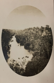
Photograph - Yarra River, Kew, 1924
Henry Beater Christian (1886-1962) , was a descendant of one of the earliest settler families in Kew. Employed at the Kew Asylum as a 'public servant', he was a skilled amateur photographer, photographing numerous scenes in Kew and on his travels around Victoria. The majority of his photographs date from 1916 to 1929. His finest photographs are housed in two photograph albums. A dated early photograph of the Yarra River at Kew.Digital copy of a photograph from page 1 of the 47-page photograph album containing 261 gelatinous silver images, loaned by Diane Washfold with permission given to digitise and hold a copy in our collection. The oval image is a birds-eye view of the Yarra with an escarpment on the right-hand side."Yarra River Kew 1924"henry beater christian (1886-1962), landscape photography, kew (vic.) — yarra river, christian-washfold collection, photograph albums -
 Port Fairy Historical Society Museum and Archives
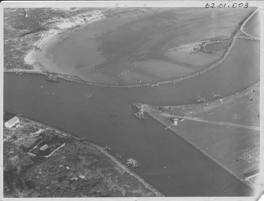
Photograph - photograph-mounted, R.W.Golding, 1925
Flight taken in 1925 by Mr R.W.Golding Black and white aerial PhotographMartins's Point Moyne Riveraerial view, martin's point, moyne river, r.w.golding, flight -
 Port Fairy Historical Society Museum and Archives
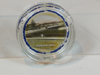
Souvenir - ashtray
.Photograph of the bridge over the Moyne River Port Fairy circa 1940.Round, glass ashtray.Moyne River, Port Fairyglass, ashtray, port fairy, photograph, moyne river -
 Port Fairy Historical Society Museum and Archives
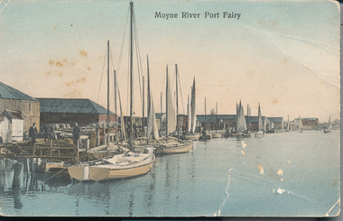
Postcard - Photograph, A.C. Aberline, Fishing boats in Mayne River
Shows the fishing fleet in the harbour this postcard was used to send a message home to family and friends regarding their stay in Port FairyA photograph of a busy fishing town and tourist mecaHand coloured photograph/postcardMoyne River Port Fairyharbour, fishing fleet -
 Clunes Museum
Postcard, SELWYN COY. STATIONER, LAUNCESTON
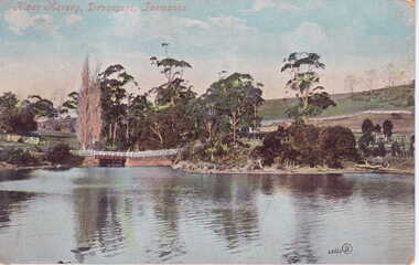
POSTCARD SENT TO MISS PERRY FROM NIECE MAUD, FROM DEVONPORT, TASMANIAPOSTCARD SENT FROM DEVONPORT, TASMANIA SENT TO MISS PERRY, CRESWICK ROAD, CLUNES OCTOBER 1906, FROM HER NIECE, MAUDRIVER MERSEY, DEVONPORT, TASMANIA.local history, photography, photographs, trembath, perry -
 Lakes Entrance Historical Society
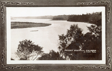
Photograph - Reeves River, 1910c
Also another copy print 8 x 13, both printed as though framedBlack and white photograph of Reeves Channel, Gippsland Lakes. It shows Rigby Island opposite the steep cliffs of mainland shore. Small island off Rigby was known as the Doughboy. Taken from Jemmys Point, natural vegetation in foreground. Lakes Entrance VictoriaReeves River from Kalimnaislands, waterways, topography -
![Photograph - Construction of the F19 [Eastern Freeway], Ron Setford, May 1976](/media/collectors/550653872162f11fb04854aa/items/68287a8a64071e7c58e6608b/item-media/68287ab064071e7c58e66255/item-fit-380x285.jpg) Kew Historical Society Inc
Kew Historical Society IncPhotograph - Construction of the F19 [Eastern Freeway], Ron Setford, May 1976
Ron Setford and his wife Grace Setford lived in Tanner Avenue, East Kew, from c.1946 to c.1995. A keen photographer, he recorded the changing face of Kew over a 20 year period. Apart from 30 photographs of built structures and places in Kew dating from 1960 and 1961, 145 of his 35mm colour slides chronicle the development of the F19 (later renamed Eastern) Freeway through the Yarra Valley in Kew over a five year period from c.1972 to c.1977. This important collection was donated to the Society by his granddaughter in 2025.This collection of 175 35mm slides is of local and statewide significance, owing to its subject matter, particularly the major development of road transport infrastructure during the 1970s with the construction of the Eastern Freeway. The photographer also took care to annotate and date most of his slides which enable the researcher to pinpoint temporal and spatial locations."Yarra River from Freeway"ron setford, eastern freeway, f19 freeway -
![Photograph - Construction of the F19 [Eastern Freeway], Ron Setford, January 1977](/media/collectors/550653872162f11fb04854aa/items/683be10f69688f11138ec6f1/item-media/683be12f69688f11138eca95/item-fit-380x285.jpg) Kew Historical Society Inc
Kew Historical Society IncPhotograph - Construction of the F19 [Eastern Freeway], Ron Setford, January 1977
Ron Setford and his wife Grace Setford lived in Tanner Avenue, East Kew, from c.1946 to c.1995. A keen photographer, he recorded the changing face of Kew over a 20 year period. Apart from 30 photographs of built structures and places in Kew dating from 1960 and 1961, 145 of his 35mm colour slides chronicle the development of the F19 (later renamed Eastern) Freeway through the Yarra Valley in Kew over a five year period from c.1972 to c.1977. This important collection was donated to the Society by his granddaughter in 2025.This collection of 175 35mm slides is of local and statewide significance, owing to its subject matter, particularly the major development of road transport infrastructure during the 1970s with the construction of the Eastern Freeway. The photographer also took care to annotate and date most of his slides which enable the researcher to pinpoint temporal and spatial locations."Freeway / River above bridges"ron setford, eastern freeway, f19 freeway -
 Warrnambool and District Historical Society Inc.
Domestic object, Drink Coasters (4)
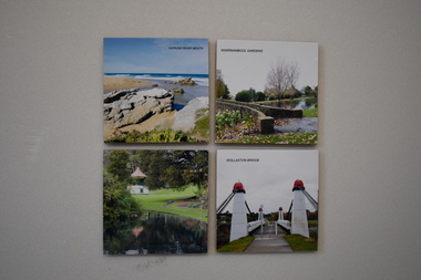
These coasters depict scenes from Warrnambool – the Botanic Gardens, The Hopkins River mouth and the Wollaston Bridge. All are areas of historical and tourist interest. The coaster were produced to raise funds for Peters Project in Warrnambool, a charity organization dedicated to bringing improved cancer care services to Warrnambool. The organization was founded in 2008 by Vicki Jellie in memory of her husband Peter who died of cancer. The major aim of the organization was realized in 2016 when the South West Regional Cancer Care Centre was opened in a new building in Ryot Street and services to assist cancer patients in Warrnambool continue to be extended. These coasters are of some interest as examples of fund-raising material produced by the Peters Project committee to assist with the campaign to bring improved cancer care services to Warrnambool..1 .2.3.4 A wooden drink coaster with a felt base and a colour photograph pasted on the top section.1 Warrnambool Gardens .2 Hopkins River Mouth .3 Wollaston Bridge .4 Warrnambool Gardenspeter’s project, warrnambool, vicki jellie, warrnambool souvenirs -
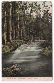
 Marysville & District Historical Society
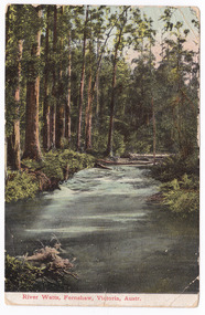
Postcard (item) - Colour postcard, Nicholas John Caire, River Watts, Fernshaw, Victoria, Austr, 1858-1918
An early colour postcard of the Watts River at Fernshaw. The original photograph was taken by Nicholas John Caire. This is one of a series of postcards of photographs taken by socialite photographer Nicholas John Caire. N.J. Caire had a great love for the area and in the late 1800's took many photographs of Marysville and its surrounds. N.J. Caire was born in 1837 in Guernsey. He arrived in Adelaide about 1860 along with his parents who encouraged his early interest in photography. He opened a studio in Adelaide in 1867 after traveling extensively throughout the Gippsland taking photographs. After marrying in 1870 he moved to Talbot in Victoria until 1876 when he opened a studio in the Royal Arcade in Melbourne. After 1885 N.J. Caire gave up his city work and made his home in South Yarra and devoted the rest of his life to outdoor photography, specializing in the bush, the gullies and the mountains of south-eastern Victoria. An early colour postcard of the Watts River at Fernshaw. The original photograph was taken by Nicholas John Caire.POST CARD This Space may be used for Correspondence. The Address only to be written he (rest obscured by postage stamp) Date stamp / MAR 4 Orange postage stamp with portrait depicting Queen Victoria 95686 To Bessie/ Hope you are enjoying yourself/ I see there was some excitement/ at the Marysville Races/ Kind regards and/ best wishes/ & love from all of/ us at 384/ Punt Road/ & William Miss Bessie Taylor/ The Chestnuts/ Marysville Vicmarysville, victoria, nicholas john caire, watts river, fernshaw, 95686, postcard, souvenir -
 Marysville & District Historical Society
Postcard (item) - Colour postcard, Nicholas John Caire, River Watts, Fernshaw, Victoria, Austr, 1858-1918
An early colour postcard of the Watts River at Fernshaw. The original photograph was taken by Nicholas John Caire. This is one of a series of postcards of photographs taken by socialite photographer Nicholas John Caire. N.J. Caire had a great love for the area and in the late 1800's took many photographs of Marysville and its surrounds. N.J. Caire was born in 1837 in Guernsey. He arrived in Adelaide about 1860 along with his parents who encouraged his early interest in photography. He opened a studio in Adelaide in 1867 after traveling extensively throughout the Gippsland taking photographs. After marrying in 1870 he moved to Talbot in Victoria until 1876 when he opened a studio in the Royal Arcade in Melbourne. After 1885 N.J. Caire gave up his city work and made his home in South Yarra and devoted the rest of his life to outdoor photography, specializing in the bush, the gullies and the mountains of south-eastern Victoria. An early colour postcard of the Watts River at Fernshaw. The original photograph was taken by Nicholas John Caire.POST CARD This Space may be used for Correspondence. The Address only to be written he (rest obscured by postage stamp) Date stamp / MAR 4 Orange postage stamp with portrait depicting Queen Victoria 95686 To Bessie/ Hope you are enjoying yourself/ I see there was some excitement/ at the Marysville Races/ Kind regards and/ best wishes/ & love from all of/ us at 384/ Punt Road/ & William Miss Bessie Taylor/ The Chestnuts/ Marysville Vicmarysville, victoria, nicholas john caire, watts river, fernshaw, 95686, postcard, souvenir -
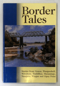 Orbost & District Historical Society
book, Border Tales, 2000
The book was compiled by Peter Allard and Geoff Alves and published by the Genoa Town Committee. Genoa is a small town in East Gippsland, Victoria. It is close to the New South Wales border where the Princes Highway crosses the Genoa River.A paperback book of 120pp titled Border tales : stories from Genoa, Wangarabell, Wroxham, Timbillica, Maramingo, Nungatta, Wingan and Gipsy Point. On the front cover is a coloured picture of the bridge across the Genoa river at Genoa. -
 Melton City Libraries
Photograph, Exford, Unknown
1867 President (Road Board), Shire President. 1856 coach house – skillion dairy. First two storey house in rural Victoria 1842. Rammed earth Shearers quarters Exford Homestead on Werribee River (formerly Exe River) Home of Simon Staughton, arrived 1841 local identities, pioneer families -
 Kew Historical Society Inc
Photograph - Yarra in Flood, 1934
Flooding of the Yarra Valley, including that section of the Yarra bordering Kew and Kew East in the north and west of the municipality, was a regular occurrence. Extreme flood events of the Yarra River are recorded to have occurred in 1891, 1901, 1916, 1923 and 1934. The Municipality of Kew's response to these floods was to enact planning decisions restricting residential development in flood prone areas following the floods of 1916, 1921 and 1934. While floods continued after the development of the Upper Yarra Reservoir (construction 1948-57), the regularity and extent of these inundations diminished.Black and white print positive. 1934 floods of the Yarra Valley. Location Fairfield looking towards wooded hillside. Houses floating in river.Reverse: "From Fairfield Park (11936?) back towards hill (Wurundjeri Spur?)"floods -- 1934, yarra valley, yarra river, fairfield park -
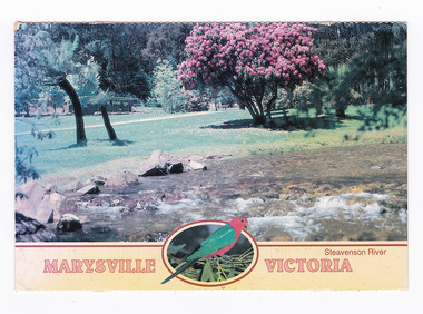 Marysville & District Historical Society
Postcard (item) - Colour postcard, Neil Cutts, Marysville Victoria-Steavenson River, Pre 2009
A postcard in a series produced by the Rose Stereograph Company in Victoria, Australia as a souvenir of Marysville.A colour photograph of the Steavenson River which flows through Marysville in Victoria. The Rose Series postcard No. 3527.POST CARD The "Rose" Series/ De Luxe Proudly Printed in/ Australia Since 1880 AFFIX/ STAMP/ HERE/ Rose Series/ Post Card No./ 3527 ADDRESS/ Nancy Oliver/ 14/150 Tyabb Road/ Mornington/ Victoria - 3931/ POSTCODE Steavenson River/ MARYSVILLE, VICTORIA, AUSTRALIA/ Photo Neil Cutts Copyright Rose Stereograph Co., Glen Waverley, Victoria (03) 9560 7772 8-3-2003 Dear Nancy/ here we are/ at Mary Lyn./ Everything is about the name nice/ pleasant & cheerful & restful meeting different people/ every day but we miss dear Nancy & Company eh?/ We did not notice any changes the prices are up./ We enjoy walking most mornings Eric enjoys/ longer walks in the afternoon. The weather so far/ has been nice cool and/ pleasant and time is passing/ quickly Hope to meet you in/ Nov. all being well./ Love Sarina & Ericmarysville, victoria, steavenson river, postcard, souvenir, rose stereograph co, 3527 -
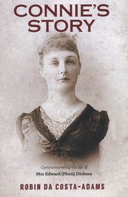 Surrey Hills Historical Society Collection
Book, Connie's Story: Commemorating the life of Mrs Edward (Plorn) Dickens, 2014
Purchased by the Surrey Hills Historical Society for the Surrey Hills Neighbourhood Centre History collection. Includes: illustrations, maps, portraits. Connie Dickens is believed to have spent some of her last year(s) in Surrey Hills. Traces the life of Mrs Edward (Plorn) Dickens, born in 1859 at River-View, Kangaroo Point, Tasmania, the third daughter of Alfred and Emily Desailly (nee Stanfield).Traces the life of Mrs Edward (Plorn) Dickens, born in 1859 at River-View, Kangaroo Point, Tasmania, the third daughter of Alfred and Emily Desailly (nee Stanfield).(mrs) constance emily rose dickens, (mrs) edward (plorn) dickens, (dr) (mr) francis desailly, (mr) alfred desailly, (miss) constance emily rosa desailly, (miss) emily desailly, (miss) florence eva desailly, (mrs) (ann) nancy sophia desailly, box hill cemetery -
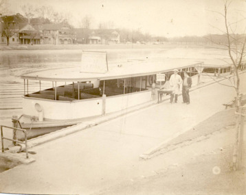 Kew Historical Society Inc
Photograph - Hicks Bros Launch at Princess Walk, circa 1953
Commercially-operated boat tours on the Maribyrnong and Yarra Rivers in Melbourne were a major tourist attraction, especially in the first half of the twentieth century. A number of companies ran ferries and motor-launches to locations such as the Riverview Tea Gardens (1909-1947) at Ascot Vale, and the Hawthorn Tea Gardens on the corner of Power Street and Riversdale Road. One of the families which ran these services was Hicks Bros, which from circa 1921 operated a ferry service from Princess Walk (Melbourne) to Studley Park. This is one of a series of 17 black and white undated photographic proofs donated to the Kew Historical Society in 2013 by the Queenscliffe Historical Museum. The series includes images of individuals, tea rooms, ferries, motor launches, ocean liners and tugs. In 1953, the owner of Hicks Bros was involved in an inquest into the drowning of a Ukrainian tourist on a ferry operated by Melbourne Ferries, a rival firm. In published reports of the inquest, reference is made to a number of photographs taken by Robert Irvine Atchison, part-owner of Hicks Bros. As the reverse of the photographs indicates copyright is held by the State of Victoria, the collection may have derived from that year.Historically significant and rare image of one of the major tour boat services which operated on the Yarra River.Faded black and white photographic proof of a ferry owned by Hicks Bros on the River Yarra at Princess Walk. Two employees stand beside the first of a number of wooden ferries. On the south side of the river, there are the pavilions of a number of boat clubs.ferries, motor launches, yarra river, maribyrnong river, studley park, princess walk, riverview tea gardens, hawthorn tea gardens, tourism - melbourne (vic.), hicks bros, hicks bros launches -
 Tatura Irrigation & Wartime Camps Museum
Photograph, 24/3/1917
Taken by photographer for State Rivers and Water Supply Commission.Medium sized black and white photograph. Sugarloaf Reservoir upper core wall, tower, tunnel, and lower dam under construction / Group of men left corner / Rocks in river bed foreground / Horse and cart off-centre left / Horse, cart, and men far right of centre / Words "Diversion Core Wall Tunnel and Riverbed" printed.victorian state rivers and supply commission, sugarloaf reservoir -
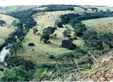 Hume City Civic Collection
Photograph
Lochton Flour Mill was established in the 1850s and is only one of a few surviving mills in Victoria. It is situated on a horseshoe bend on the Deep Creek at Bulla.A coloured photograph of a horse shoe bend in a river and the open flood plain. The river is tree-lined. The ruins of a stone building are on the river bend. A damaged fence and prickly pears are in the foreground.lochton mill, deep creek, hunter, william morrison, george evans collection -
 Orbost & District Historical Society
book, Grove, Carl, BUKAN MUNGEE
C.H. Grove spent about 40 years in the area, information is mainly derived from his own recollections and "reliable sources". Charles Henry [Carl] Grove died on 17/4/1938 at Box Hill at the age of 88 and was buried in Orbost. Prior to coming to the Snowy River district, Carl worked as overseer on Buchan Station. In 1880, he selected land at Newmerella after first coming here in 1874 with early selector James A Robertson.He was one of the first selectors at Orbost - in 1880 he selected 320 acres at Newmerella, which he called „Ulinda‟ He married Annie Robertson in 1876. Carl was a farmer, hop and seed grower and nurseryman. He was an elected Councillor of the newly formed Tambo Shire in 1882, and then in 1892 to the Orbost Shire where he served for many years filling varioius public roles. In 1911, he shifted to Queensland, but later returned to Victoria and died at Box Hill. (Ref. Nov 2014 Newsletter) This is a useful reference tool.A carbon copy of a typeset manuscript / transcript book entitled "Bukan Mungee" containing historical and geographical information of the area "bounded by the Snowy River in the east, the Tambo river in the west...and with the following leaseholds, Ensay, Gillingall, and Gelantipy on the north, with Kilmore and Corringle stations on the south..."grove-carl bukan-mungee corringle newmerella snowy-river tambo-river -
![Flooding at Chipperfield's Boathouse [East Kew], 1934](/media/collectors/550653872162f11fb04854aa/items/58cbaad5d0cec425b474bfb1/item-media/58cf6fbdd0cf9f331490feb0/item-fit-380x285.jpg) Kew Historical Society Inc
Kew Historical Society IncPhotograph, Flooding at Chipperfield's Boathouse, 1934
Living with natural processes was frequently a challenge to early European settlers and later residents of what was in the 1850s administered by the Borondara Road Board. This was compounded by the area being bounded on three sides by rivers (Yarra River, Koonung Creek and Gardiner's Creek). In 1849, the historian James Bonwick recorded that "our district [Kew] suffered considerably. Mr Wade speaks of 80 acres, out of 100 acres of his cultivated paddock, covered by water." Newspapers continued to describe major flooding in Kew in 1863, 1869, 1878, 1880, 1889, 1891, 1916 and 1934. While the construction of the Upper Yarra dam in 1957 reduced the levels of flowing downstream, local and riverine floods continue.The Kew Historical Society's pictures and map collections testify to the impact of flooding in the district. They have historical importance in documenting the extent of flooding in the district and its affects on homes, services and recreation. Numerous photographs record flooding throughout the Twentieth Century.Floods in North Kew, 1934. Chipperfield's Boathouse and the adding Moorings was located beside the Yarra River near the corner of Willsmere and Kilby Roads. The flood reached the roof of the Moorings, which can be seen in the photo.floods (kew), floods (kew) 1934, yarra river -
Glenelg Shire Council Cultural Collection
Negative - Negative - View of Nelson, 1934
Zillah Maschmedt took a series of photographs of Portland and the surrounds in 1934. She was a school teacher from South Australia.Negative for black and white photo. View of Nelson from Glenelg River, bridge over river visible.photography, zillah maschmedt -
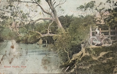 Kew Historical Society Inc
Postcard, River Yarra, Kew, 1905-1914
The Kew Historical Society's postcard collection includes views of Kew, Melbourne and Greater Melbourne as well as those including overseas scenes sent or received from Europe or the Middle East. They date from the 1890s to the 2000s. These postcards may or may not include the name of the publisher or printer. A number of the cards were published as parts of popular series. A way of dating early postcards is to identify whether the reverse was divided by a central line which became the norm after 1902 in the United Kingdom. However, other postcards produced after this date do not always conform to this print layout.One of a series of pictorial postcards showing a woman on a bicycle near to the River Yarra in Kew.Polychrome postcard of the River Yarra at Kew, showing a woman with a bike (right) looking away from the River.My dear friend I suppose you will think I am a "beauty", but I have no excuse to offer for not writing, only the longer I put it off the longer I want to. I hope the change did you a lot of good & that you feel quite well & strong. Everything here is something about the same. Our two new ministers are nice but I like Mr Dowsing better so far. The weather lately is glorious, just the thing for long walks. Jane Rowe & I go for a walk after church on Sunday nights. That is the most walking I do lately. No room for more. Love from your friend C.G.[sic]postcards -- kew (vic.), postcards -- yarra river -- kew (vic.), colour postcards -- kew (vic.) -
 Kew Historical Society Inc
Photograph - Flood at Fairfield Park, 1934
Flooding of the Yarra Valley, including that section of the Yarra bordering Kew and Kew East in the north and west of the municipality, was a regular occurrence. Extreme flood events of the Yarra River are recorded to have occurred in 1891, 1901, 1916, 1923 and 1934. The Municipality of Kew's response to these floods was to enact planning decisions restricting residential development in flood prone areas following the floods of 1916, 1921 and 1934. While floods continued after the development of the Upper Yarra Reservoir (construction 1948-57), the regularity and extent of these inundations diminished.Black and white print positive. Yarra River at Fairfield in 1934. Major flood resulting in submerged buildings in middle ground and onlookers on far bankReverse: "Flood of Yarra at Fairfield Park 1934"fairfield park, yarra valley, river yarra, floods -- 1934 -
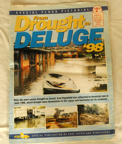 Orbost & District Historical Society
pictorial magazine, From Drought to Deluge '98, 1998
This magazine cost $2.50 and was produced to support the East Gippsland Red Cross Flood Appeal. Following heavy rain in East Gippsland in June, 1998, major flooding occurred in the Mitchell, Nicholson, Tambo, Snowy, Brodribb and Bemm Rivers. Other streams in the region also experienced high flows during this time. Probably the most severe direct impacts of the floods were to the rural sector.This magazine is a contemporary record of a significant local event.Two copies of a magazine pictorial of the floods of 1998. Photos are black and white. They are of Bairnsdale, Orbost, Lakes Entrance, Raymond Island, Bemm River, Bruthen , Tambo and Cabbage Tree. flood-1998 flood-east gippsland disaster-floods -
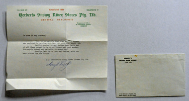 Orbost & District Historical Society
letter, 1968
Massey Herbert was a prominent Orbost citizen being the youngest candidate In Orbost's history to have been elected to the shire council. This letter was written by Massey Herbert for Marilyn Morgan as a job reference. Marilyn worked at Herbert's Snowy River Store in Nicholson Street, Orbost from 1.1.1966 until 27.4.1968.Associated with a well-known Orbost business which started in 1888 and finally closed in c.1970.A typed letter of reference from Massey Herbert for Marilyn Morgan. It is typed on a Herbert's Snowy River Pty Ltd letter head. The header is green and red print and the text black. The envelope is 2599.2.herbert-massey snowy-river-stores morgan-marilyn -
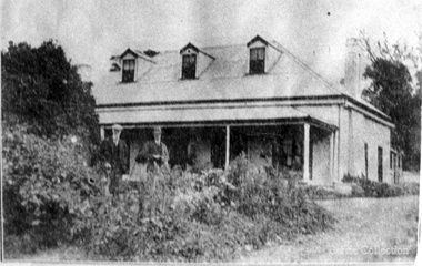
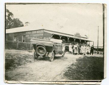 Orbost & District Historical Society
black and white photograph, 1900
This photograph was taken in 1900 at Buchan. The River View Hotel was established in Buchan in 1884 and was possibly first called the Cricket Club Hotel. The isgn at the front of the building suggests that a ? Cameron ran the establishment.This an early pictorial record of Buchan in the 1900s.A small black / white photograph of a group of people standing outside a hotel A motor vehicle is in the foreground and another behind the people. On the right side of the wooden building is a sign indicating that this is River View House an accommodation business. At the front is a sign with the name ?. Cameron on it.on front - "Buchan Caves - 1900" on back - "E.A. Paige"buchan-river-view-hotel -
 Port of Echuca
Coloured Photograph, 04/03/1984
The P.S Adelaide was launched on 21st July 1866. It was owned by J.G.Grassie from Poon Boon Station and the Officer Family of Murray Downs Station Swan Hill. The Adelaide was named after the niece of the Officer Bros, Adelaide Blackwood. The shipwright who built her was George Linklater. The Adelaide brought wool and passengers from the wool stations on the Murray and Darling Rivers down to the Echuca Wharf. In 1872 she was sold to David Blair & Sons. She was used to bring timber from the Barmah Forest to the Echuca Wharf. She did this work for the next 80 years. In 1953 she was tied up near the Mill and left. In 1958 she went to Paringa South Australia to work in the sawmill industry again. In 1960 the Echuca Apex Club and The Echuca Historical Society raised enough funds to buy the P.S. Adelaide and return her to Echuca. In November 1963 she was lifted out of the water and placed in Hopwood Gardens as this was thought to be a way of preserving her. In 1984 it was decided to return her to the water to resume work as a passenger vessel. In that time the Port of Echuca and the Echuca Wharf had been restored as a Tourist Precinct. This photograph shows the beginning of the task to return her to the river. It took several weeks in March 1984.The P.S Adelaide is extremely significant as it it the oldest known wooden hulled paddle steamers in the world. She was built in Echuca in 1866 and still operates on the Murray River today. She has worked in the Wool Industry, the Timber Industry and the Tourist Industry.This is a coloured square photograph of an orange front end loader clearing a track from Hopwood Gardens down to the river. The track was used to bring the P.S Adelaide from the gardens back into the river. The P.S Adelaide is in the background. The paddle steamer appears to be up on a trailer of some sort and is surrounded but plastic orange temporary fencing. There are small mounds of soil in the foreground.On the orange front end loader are the numbers "5900" and the word "case." p.s. adelaide, grassie, j.g, port of echuca, linklater, george, poon boon station, blair, david, murray river, darling river, logging industry, officer brothers., barmah forest, fulton & shaw, hutchinson, kevin, murray downs station, blackwood, adelaide -
 Ballan Shire Historical Society
Map - Map. Bungal, Department of Lands and Survey, Bungal, County of Grant, 09/09/1926
A map of Bungal in the 1920's showing the allotments, and the size, with the names of the residents. It shows the roads and the Western and Eastern Moorarbool River, and the Whipstick State Forest.Cream coloured map of Bungal in the County of Grant, bounded by the the East Moorarbool River on the East, and the State Forest on the South. It is marked with the scale of chains and the number L.358. Lithographed at the Department of Lands and Survey. Melbourne by W. J. Butson on 9.9.1926. It shows the land allotments with names of owners.Coloured pen marks and circled numbers on various areas. Price 2 shillings marked on bottom right hand edge.bungal, kerrit bareet, egerton, lal lal, borhoneyghurk, bungeeltap, ballark, yaloak, gorong, moorarbool west -
 Bendigo Historical Society Inc.
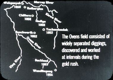
Slide - DIGGERS & MINING: THE DIGGINGS - THE DIGGERS
Diggers & Mining. The Digging - The Diggers. Slide depicts: Murrey River, Kiewa River, Ovens River, King River. The Ovens Field consisted of widely separated diggings, discovered and worked at intervals during the gold rush. Markings: 23 994.LIF:6. Used as a teaching aid.hanimounteducation, tertiary, goldfields