Showing 2496 items matching " wagon/cart/dray"
-
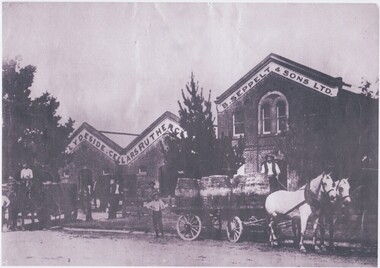 Rutherglen Historical Society
Image, c1900
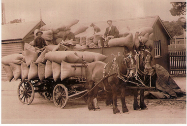
Black and white photograph of the front of a wine cellar building with horse carts loaded with barrels.On front of building: "Clydeside Cellars, Rutherglen | B Seppelts & Sons Ltd."wineries, wine cellars, clydeside cellars, b seppelts & sons ltd, seppelts -
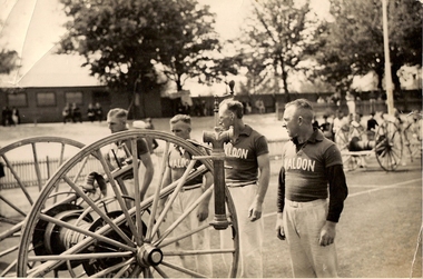 Lions Club of Maldon Inc.
Photograph, Maldon Fire Brigade Running Team C1950, C1950
Black and White photograph depicting four men behind running cart at unspecified location -
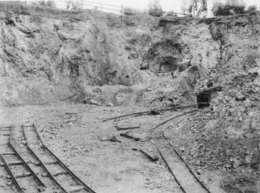 Stawell Historical Society Inc
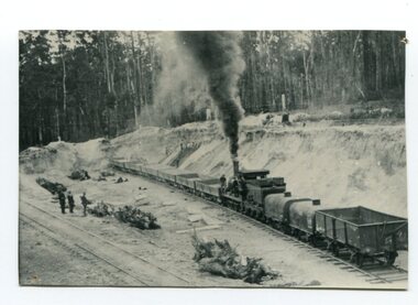
Photograph, Jubilee Open Cut Wonga Company Cyanide Gold Recovery 1899
B/W photo Jubilee Open Cut Wonga Company Cyanide Gold Recovery 1899Open Cut with sections of rail track bottom left. Ore cart at right of photo. stawell mining -
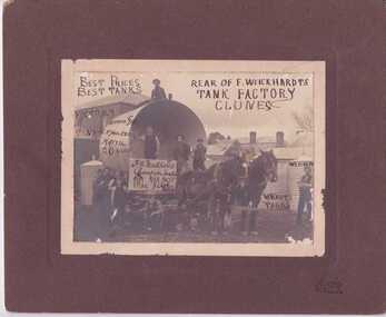 Clunes Museum
Photograph - PHOTOGRAPH WEIKHARDT HORSE AND TANK, HORNBY - CLUNES, CIRCA 1900
PHOTOGRAPH OF HORSE AND CART WITH TANK-WEICKHARDT'S TANKS. REAR OF F.WEICKHARDT'S TANK FACTORY CLUNESF.W. WEICKHARDT - CHAMPION TANKS ARE BEST 4000 GAL. C. F. SCHULZE. KATYweickhardt's tank factory, weickhardt -
 Clunes Museum
Artwork, other - LITHOGRAPH, WILLIAM TIBBITS, CIRCA 1870
IT IS ON PERMAMENT LOAN FROM HEPBURN SHIRE, LITHOGRAPH BY WILLIAM TIBBITS, CIRCA 1870. HE WAS A WELL KNOWN FIGURE TO BE SEEN RIDING HIS BICYCLE FROM ONE GOLDFIELD TO ANOTHER WHERE HE PAINTED MANY OF HIS FAMOUS PAINTINGS.LITHOGRAPH PAINTING OF CLUNES TOWN HALL WITH HORSE AND CART BY ARTIST WILLIAM TIBBITS - FRAMEDCLUNES TOWN HALLillustration, lithograph, hepburn shire, tibbits -
 Williamstown Historical Society Inc
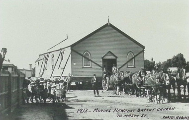
Photograph - Newport Baptist Church, Newcastle Street
Photograph - Moving Newport Baptist Church to Mason St, Newport, by horse and cart (1913) newport baptist church, newcastle street, mason street, newport -
 City of Moorabbin Historical Society (Operating the Box Cottage Museum)
Photograph - Plateway (Wheelway) Steel, circa 1885
By the later 1800s the dirt roads in the then out-lying areas of the City of Moorabbin became dangerous, and almost impassable due to huge potholes and muddy swampy areas. The heavily laden market gardener’s carts regularly broke axles and wheels, and horses foundered on their way to the Melbourne markets. Even worse, the heavier “iron maidens”, carrying their malodorous loads of sewage from Melbourne’s inner suburbs for dumping in the outlying areas of the City of Moorabbin, also got bogged in the mire. It was decided that a practical solution to this problem was to install a metal plateway on the side of the problematic roads. In about 1887 the Moorabbin Shire Centre Road, in the Brighton East area, two parallel metal rails were installed so that the wheels of carts could run along smoothly, the horse travelled in the filled, middle area between the rails. Point Nepean Road plateway was removed in 1930 and Centre Dandenong Road plateway was removed in 1934-35. The worn plateway along Centre Road, East Brighton (now known as Bentleigh), was gradually taken up in several pieces, commencing in the the1920s, when its condition deteriorated and it caused a hazard to bikes, pedestrians, motor-cycles and the few early cars. The early steel plateway, constructed by David Munro, and opened on 23rd March 1885 by Thomas Bent, was built along Nepean Highway, between Asling St. and Bay St. The Point Nepean Track was subsequently extended into Moorabbin with branches along Centre, Cumins, South, Wickham, and Keys Roads, the total length was 13 miles. In 1908-1909 plates were laid along Centre Dandenong Road to Ross Street Bentleigh This innovative solution proved successful and was used until gradually the main roads were upgraded, and motorised vehicles started to appear. Two parallel metal rails were installed in the right hand side of a few main roads in the Shire of Moorabbin so that the wheels of heavily-loaded market gardener's carts on their way to markets in Melbourne could run along smoothly. The horse pulling the carts travelled in the filled, middle area between the rails. The Steel Plateway was constructed by David Munro, and opened on 23rd March 1885 by Thomas Bent. The wheelway first only ran along Nepean Highway, but it soon extended from Centre Dandenong Road, along Nepean road to its junction with Chapel Street, St Kilda. Later branch lines were built along Centre Road, Bentleigh as far as Warrigal Road and, according to early photographs, along Wickham Road Moorabbin as well. This innovative solution proved successful and was used until gradually the main roads were upgraded, and motorised vehicles started to appear. There was a problem with the wheelway : there was only a single set of rails and this was established on the right-hand side of the Nepean Road, travelling towards the city. Traffic FROM the city travelled on the correct or left-hand side of the road. The exception to this rule was the malodorous iron-clads, heavily riveted iron carts, generally travelling in convoy, carrying several tons of human effluent out of Melbourne to be trenched-in in the sandy soil of the Moorabbin district. Moorabbin City Council donated and installed a small section of Plateway at Box Cottage Museum in 1984melbourne, brighton, moorabbin, roads, plateway, wheelway, transport, st kilda, bent thomas, munro david, market gardens, steelway, carts horse-drawn, iron maidens, point nepean track -
 Whitehorse Historical Society Inc.
Photograph, John Williams
The Mitcham Reservoir was completed in 1923. Excavation was by horse drawn scoops and drays. The site is accessed by Agra Road MitchamTwo copies of a black and white photograph of John Williams of East Doncaster Road, Mitcham, standing in front of the Mitcham Reservoir construction site in c1922williams, john, mitcham reservoir -
 Otway Districts Historical Society
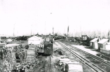
Photograph, Beech Forest Railway Station, 1910, 1910
By 1910 revenue from the Beech Forest railway was $15,500, working expenditure $12,000, with a net loss (including interest charges) of about $4,000. This and the following year were the lowest net losses ever experienced. Passenger journeys rose steadily, outwards goods traffic rose to a record 12,959 tons (in 1911), and inwards goods traffic was a record 3,359 tons.. The railway station possessed a goods shed, stock race and yards, engine shed, coal stage, crew cabins, a refreshment room, and a four-roomed station building, with the station staff to match. Beech Forest was the principal despatch centre at this stage for split timber. Bill Devitt laid a timber tramway to the Beech Forest railway station to cart the palings for on-shipment..B/W. 177mm x 271mm. A general view from the eastern end of Beech Forest station in 1910. Note the Goods Shed, three tracks with No.3 Road having a NU louvre van and loaded NQR wagons, timber stacks to the left, and Devitt's Tramway with unloaded trolleys at the lower left. To the right, crew cabins with shops and houses in the background.beech forest; railways; timber; tramway; -
 Orbost & District Historical Society
black and white photograph, August 1897
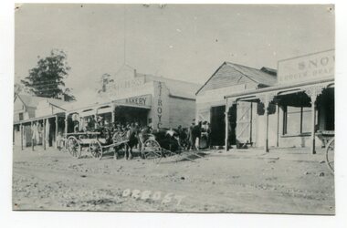
This photograph shows Nicholson Street, Orbost with horse teams in front Of Borland's Blacksmith shop and Royce's Bakery net door in August 1897.This is a pictorial record of the main street of Orbost in the late 19th century.A black / white photograph of the main street of Orbost. The road is unsealed. There are several wooden buildings facing the road and a cart with a team of horses is standing outside the blacksmith's building. A small child is standing behind the cart and several men are outside the bakery.on front - Orbostnicholson-street-orbost orbost-township borlands-blacksmith royces-bakery main-street-orbost -
 Bendigo Historical Society Inc.
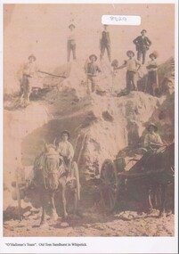
Photograph - Sand mining at the Whipstick
Old Tom mine included quartz mining and open cut mining. Today the remains of the battery site, cyanide plant, hydrolic sluicing and a 1930's puddler can be seen. It was operating in August 1874 and was taken over in 1897 by an English syndicate, J. R. Syndicate. By 1899 the mine had reached 500 feet in depth . The mine closed c. 1901.8529 Sand mining at Old Tom mine the Whipstick, Eaglehawk. O'Halloran's team of nine men and two horses and carts. Two men with horse and carts; and seven men on top of the sand deposit. A4 copy of 1513 Box 25sand mining, whipstick, old tom mine -
 Orbost & District Historical Society
black and white photograph, late 19th century - early 20th century
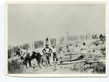
This photograph shows land clearing at Bendoc. From 1845 the Bendoc area was part of pastoral leases. In the 1850s alluvial gold was discovered in the Bendoc River. This was quickly exhausted, and a number of mines began successful reef operations. At the head of the river, the settlement of Clarkville clustered round several other mines. Many miners, including numbers of Chinese, sluiced the rivers. The population of the area was as high as 500 during this period. The township was surveyed in 1869 and the hotel built in 1870. This building was burnt down in the early 1900s and rebuilt. A school was also begun at this time. In the 1870s there was a decline in gold mining. Some miners selected land, which in many cases is still held by descendants. Dairying was common in the early days, supplying a butter factory at the New South Wales border, and a milk factory at Orbost in more recent times. Wheat was grown for the settlers' own use and ground at Bombala. Now beef cattle grazing is the main occupation. (info. from Victorian Places)This is a pictorial history associated with the early settlement of Bendoc in East Gippsland.A badly distorted black / white photograph of a horse drawn wagon, three men and two women clearing land.on back - "Clearing land at Bendoc"bendoc-land-clearing bendoc-early-settlement -
 Orbost & District Historical Society
black and white photograph, late 19th / early 20th century
This is a photograph of the gravel pit at Newmerella, near Orbost. This pit was used during the construction of the Orbost to Bairnsdale Railway line.This item is associated with the history of the Orbost-Bairnsdale railway line and therefore reflects the role that the rail line played in the social and economic history of Orbost. The Bairnsdale-Orbost railway was opened in 1916 to serve the agricultural and timber industry. Because of the decline in traffic and heavy operating costs, the line was finally closed in August, 1987. A black / white photograph of a small steam engine with open freight wagons at a gravel pit. There are some men watching. -
 Tatura Irrigation & Wartime Camps Museum
Book, The Rodney Store, 2005
Compiled for centenary of the Rodney Store in 2005White cover, black writing, photograph of store including shopkeepers, horse and draw, covered wagon. 1905-2005merrigum, books, history, local -
Tatura Irrigation & Wartime Camps Museum
Wagon, 1940's
Made by internee at Camp 3, Tatura. Used by children at the camp.High sided handmade wooden wagon, 2 sets of wheels, painted maroon on inside of body and green on the outside.wagon, roscher i, handcrafts, woodcarving, wooden wagons -
 Stawell Historical Society Inc
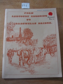
Book, Peter Davie, From Ledcourt Crossing to Dadswells Bridge, 1980
History of Dadwells bridge area. Written for the Back-To-School. 75th Anniversary Different families of the district contributed articles & Photographs Fawn Card cover with brown print and drawing of a house with a bullock wagon in front. surround by a single line borderFrom Ledcourt crossing to Dadswell Bridgestawell -
 Whitehorse Historical Society Inc.
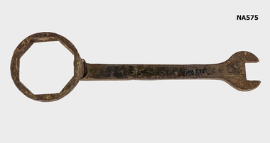
Tool - Spanner
An iron wrench used to tighten caps nuts of wooden wagon wheels. On the other end to loosen smaller nuts.trades, wheelwrighting -
 Port Fairy Historical Society Museum and Archives
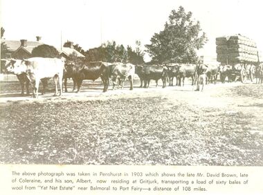
Newspaper - Newspaper article
This photo was taken in Penshurst in 1903 which shows the late David Brown, late of Colerain Balmoral and his son, Albert, now residing at Gritjurk, transporting a load of sixty bales of wool from “Yat Nat Estate” near Balmoral to Port Fairy —a distance of 108 miles.Black and white photograph from a newspaper article with a large wool laden wagon with 14 bullocks yoked up The above photo was taken in Penshurst in 1903 which shows the late David Brown, late of Colerain Balmoral and his son, Albert, now residing at Gritjurk, transporting a load of sixty bales of wool from “Yat Nat Estate” near Balmoral to Port Fairy —a distance of 108 miles.transport, rail, road, bullocks, wagon, carrier, penshurst, balmoral, albert brown, david brown, wool bales, yat nat estate, gritjurk -
 Flagstaff Hill Maritime Museum and Village
Functional object - Ship's Wheel Hub, 1886-1908
The Falls of Halladale was an iron-hulled, four-masted barque, used as a bulk carrier of general cargo. She left New York in August 1908 bound for Melbourne and Sydney. In her hold was general cargo consisting of roofing tiles, barb wire, stoves, oil, and benzene as well as many other manufactured items. After three months at sea and close to her destination, a navigational error caused the Falls of Halladale to be wrecked on a reef off the Peterborough headland on the 15th of November, 1908. The captain and 29 crew members survived, but her cargo was largely lost, despite two salvage attempts in 1908-09 and 1910. The Court of Marine Inquiry in Melbourne ruled that the foundering of the ship was entirely due to Captain David Wood Thomson's navigational error, not too technical failure of the Clyde-built ship. The Falls of Halladale was built in1886 by Russell & Co., at Greenock shipyards on the River Clyde, Scotland for Wright, Breakenridge & Co of Glasgow. She was one of several designs of Falls Line of ships named after waterfalls in Scotland. The company had been founded between 1870- 1873 as a partnership between Joseph Russell, Anderson Rodger, and William Todd Lithgow. During the period 1882-92 Russell & Co. standardised designs, which sped up their building process so much that they were able to build 271 ships during that time. The Falls of Halladale had a sturdy construction built to carry maximum cargo and able to maintain full sail in heavy gales, one of the last of the 'windjammers' that sailed the Trade Route. She and her sister ship, the Falls of Garry, were the first ships in the world to include fore and aft lifting bridges. Previous to this, heavily loaded vessels could have heavy seas break along the full length of the deck, causing serious injury or even death to those on deck. The new, raised catwalk-type decking allowed the crew to move above the deck in stormy conditions. The Falls of Halladale shipwreck is listed on the Victorian Heritage (No. S255). She was one of the last ships to sail the Trade Routes from Europe and the Americas. Also of significance is that the vessel was one of the first ships to have fore and aft lifting bridges as a significant safety feature still in use on modern vessels today. The subject model is an example of an International Cargo Ship used during the 19th and early 20th centuries to transport goods around the world and representing aspects of Victoria’s shipping industry. Wagon wheel hub with spoke butts. Holes for hardware fittings are visible. Recovered from the wreck of the Falls of Halladale. Noneflagstaff hill, warrnambool, flagstaff-hill, flagstaff-hill-maritime-museum, shipwreck-coast, flagstaff-hill-maritime-village, wheel hub, falls of halladale, russell & co., wreck artifact, cart wheel, ship's wheel, navigation, ship's wheel hub -
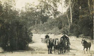 Lakes Entrance Historical Society
Postcard - Old Bunga Road
Black and white postcard showing two horse drawn wagons crossing Bunga Creek on old Bunga roadwaterways, roads and streets, transport -
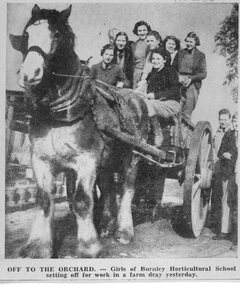 University of Melbourne, Burnley Campus Archives
Newspaper - Newspaper Cutting, June de Chaneet, Off to the Orchard, C. 21.06.1939
Photograph of carthorse and dray with 8 girls seated on it. Front left seated: Eleanor Parsons, front right seated June de Chaneet. 3 out of the 8 girls were identified as: Eleanor Parsons (1939), June de Chaneet (1939) and Jay Leach (M.J. Leitch? 1939) in 1938 or 1939. Caption, "Off to the Orchard - Girls of Burnley Horticultural School setting off for work in a farm dray yesterday." female students, eleanor parsons, jay leach, m.j. leach, students working outside, horse, dray, june de chaneet -
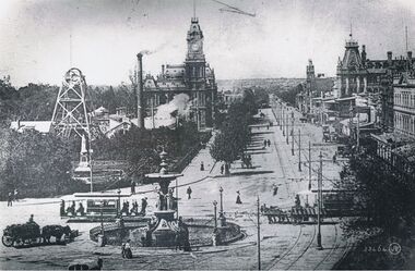 Bendigo Historical Society Inc.
Postcard - CHARING CROSS, VALENTINE POSTCARD,1910
B+W photo of Charing cross from a 'Valentine' postcard photograph c1910 (details J. Lerk) streetscape from elevated position looking from Charing Cross down Pall Mall towards White Hills. Depicts: Alexandra fountain; electric tram; horse drawn wagon, dray, vehicles; Hustlers Royal reserve No2 mine, poppet heads, chimney; post office; tram power poles; buildings fronting Pall Mall; Pedestrians; trees; Queen Victoria statue; Colonial bank. Inscription: Lower right '53464 JV'.place, bendigo, view over alexandra fountain -
 Whitehorse Historical Society Inc.
Photograph, P. Raftis and Son, Blackburn
Patrick Raftis established a fuel and fodder store in Blackburn about 1916Black and white photograph of the P. Raftis chaff and grain store in Blackburn in the 1920's. Two horse drawn drays and four men in the photograph.|See also ND3272 & ND3319p. raftis and son, fuel and produce merchants -
 Bendigo Historical Society Inc.
Photograph - On the goldfields
BHS CollectionWorking on the Goldfields. Three men with shovels on the RHS, two horses and drays centrally positioned; and men building a building frame, which appears to have animal carcasses hang up. goldfields, surface mining activity -
![Workers, horses and drays in Burwood Road [Hawthorn]](/media/collectors/550653872162f11fb04854aa/items/661f4c86ac7f9cfd1fd6c658/item-media/661f4d6bac7f9cfd1fd722a1/item-fit-380x285.jpg) Kew Historical Society Inc
Kew Historical Society IncPhotograph - Workers, horses and drays in Burwood Road [Hawthorn], E.J. Dower, 1913
One of a series of photographs, taken by Edgar James Dower in the second decade of the twentieth century. Born and raised in Olinda, his family later moved to Surrey Hills. He worked as an adult as a clerk in the city office of the Metropolitan Gas Company, and in his role as a 'collector', he was able to photograph scenes including the construction of tramlines and associated buildings in Kew, Hawthorn, Camberwell and Surrey Hills. Later he established a real estate agency with his brother - the E.J. Dower Real Estate Agency, Dandenong Office.The image is an historically significant record of the development of transport infrastructure which was used to connect Victorians in the first two decades of the twentieth century. This development resulted from increases in population and the consequent extension of Melbourne's suburbs. The photographs, both individually and collectively, richly detail the labour of workers and the tools and machinery used to create and extend Melbourne's tram network in the years preceding and during World War 1.Digital copy of an original mounted photograph depicting construction workers, horses and drays Hawthorn. The intense activity involved collecting materials for transport to the construction site in Cotham Road, Kew. Annotated recto: "Unloading trucks of metal for Kew Electric Tram Line in Cotham Road / At Hawthorn Railway Siding" Annotated verso: "Taken by E.J.D. / 1913"theme --- travelling by tram, theme -- connecting victorians by transport and communications, cotham road -- kew (vic.), trams -- kew (vic.), hawthorn railway station -
 Lakes Entrance Historical Society
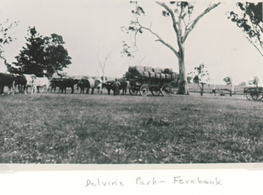
Photograph - Wool Wagon, Delvine Park sheep station Lindenow Victoria, 1890 c
Delvine Park was settled by Scott family in 1843Black and white photograph showing a large bullock team and driver with a loaded wool wagon preparing to leave Delvine Park sheep station Lindenow Victoria. Also a second black and white photograph taken of loaded wool wagon beside woolshed at Delvine Park which was the oldest in the area. transport, wool industry -
 Phillip Island and District Historical Society Inc.
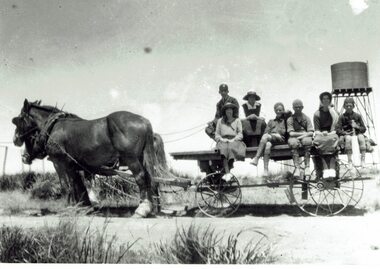
Photograph, Picnic at Nobbies, 1917
The double-storey homestead with 1920s Arts and Crafts styling was built by A.K.T. (Albert Keaston Trenavin) Sambell, the the island’s first shire president. It sits just above the original site of the homestead of the pioneering McHaffie brothers, the Island’s first settlers.HistoricalLarge black and white photograph of a flat topped cart with no sides, pulled by 2 draught horses. Water tank on stand in rural background & people sitting on the cart. 3 women wearing hats and 4 boys, one holding a cricket bat.Off to the Nobbies for a day's picnic - 1917 from "Trenavin Park". Keaston Sambell driving. Sitting behind him - Betty Parker and on side of vehicle from left.-May Lambert, Jim Patterson, Jim Blake, Carmen Sambell, Bill Sambell.trenavin park phillip island, a.k. t. sampbell, betty parker, jim patterson, jim blake, carmen sambell, bill sambell, may lambert -
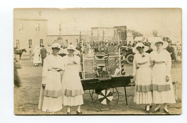 Orbost & District Historical Society
black and white photograph, C1914-1918
This photograph shows ladies at a patriotic carnival selling goods to help troops during WW1. The Australian Red Cross Society (ARCS) was formed just after the outbreak of the First World War in August 1914, originally as a branch of the British Red Cross. It came into being as a branch of the British Red Cross Society on August 13th 1914 to succour the wounded in the First World War.This is a contemporary record of a significant event in Orbost. It reflects the involvement of Orbost, a small town, in the efforts of the Australian Red Cross Society to provide comforts to soldiers during World war 1.A black / white photograph / postcard of four ladies in uniforms (nurses?) standing on both sides of a cart.on back - "Patriotic Carnival - 1914-1918" -
 Phillip Island and District Historical Society Inc.
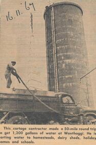
Newspaper Clipping, Water Cartage, 16/11/1967
Collection of newspaper clippings from scrap book 1960 - 1973Article about water carting to homesteads, dairy sheds, holiday homes and schools in November 1967.phillip island water cartage, jean jamieson -
 Phillip Island and District Historical Society Inc.
Photograph
Part of collection donated to the Museum by Mr. Bernard Grayden. 1975View of man driving horse and cart with dog, crossing bridge on unmade road (Road to Nobbies)The Road to the Nobbies, Cowes Phillip Island, Victoria. The Rose Series P3427local history, documents, postcards, horse and cart, cowes, phillip island, sepia postcard, bridge