Showing 762 items
matching aerial views
-
 City of Ballarat Libraries
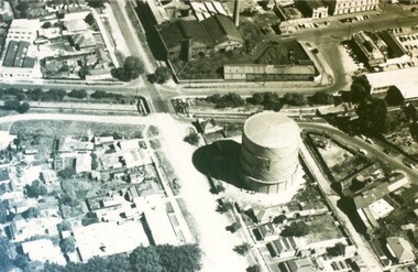
Photograph - Card Box Photographs, Gas Works, Ballarat circa 1968
... aerial view... of Albert and Dana Streets. gas works aerial view manufacturing ...These gas works were located on the corner of Albert and Dana Streets.gas works, aerial view, manufacturing, albert street, dana street -
 City of Ballarat Libraries
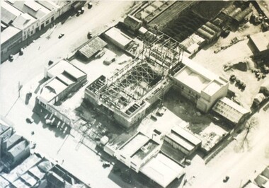
Photograph - Card Box Photographs, Aerial view of the Civic Hall under construction, Ballarat circa 1951
... Aerial view of the Civic Hall under construction, Ballarat...aerial view... as it was being constructed. civic hall ballarat mair street aerial view ...This photo shows the buildings still standing around the Civic Hall as it was being constructed.civic hall, ballarat, mair street, aerial view, armstrong street north, building, construction, public building -
 Canterbury History Group
Photograph - Aerial view of quarry, 1963
... Aerial view of quarry... melbourne Aerial view of quarry Photograph Back and white aerial ...Melbourne 1963 ProjectBack and white aerial photograph taken in 1963 of Canterbury / Balwyn brickworks area, showing the quarry behind Rochester and Mont Albert Roadscanterbury, rochester road, mont albert road, quarries, brickworks, john august reserve -
 Bendigo Military Museum
Photograph - Aerotriangulation Production – Army Survey Regiment, Fortuna, Bendigo, c1993
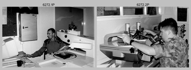
This is a collection of eight photographs of Air Survey Squadron personnel operating aerotriangulation equipment at the Army Survey Regiment at Fortuna, Bendigo, c1993. PUG4 devices were used by technicians to stereoscopically view the photography containing the survey control points and the mapping aerial photography. The Control points were transferred from the control photography to the mapping diapositives of aerial photography by drilling their locations into the photographic emulsion. The Zeiss (Jena) Stecometer analytic stereocomparator for air photography shown in photo .1P was introduced at Air Survey Squadron in 1963. Wild PUG4 point transfer devices shown in photos .2P to .4P were introduced in c1968 superseding the PUG2 devices. See item 6195.19P for more photos and descriptions of Air Survey Squadron personnel and aerotriangulation equipment.This is a set of eight photographs of Air Survey Squadron personnel operating aerotriangulation equipment at the Army Survey Regiment at Fortuna, Bendigo, c1993. The photographs were on 35mm negative film and were scanned at 96 dpi. They are part of the Army Survey Regiment’s Collection. .1) - Photo, black & white, c1993, Zeiss (Jena) Stecometer, SPR Kim Baker. .2) - Photo, black & white, c1993, Wild PUG4 point transfer device, CPL Paul Bouton. .3) to .4) - Photo, black & white, c1993, Wild PUG4 point transfer device, L to R: CPL Darren Scott, CPL Paul Bouton. .5) to .6P) - Photo, black & white, c1993, CPL Doug Willis. .7) - Photo, black & white, c1993, WO2 Noel ‘Macca’ McNamara. .8) - Photo, black & white, c1993, SGT Barry Miller..1P to .8P - There are no annotations.royal australian survey corps, rasvy, army survey regiment, army svy regt, fortuna, asr, aerotrig -
 Ballarat Tramway Museum
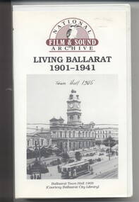
Film - Video cassette tape and box, Chris Long, "Living Ballarat 1901 - 1941", 1990
Yields information through movie films of the 1960's of Ballarat trams operating in the streets of Ballarat and has a strong association with the maker - National Film and Sound Archives and Chris Long.Video cassette in a plastic case, titled "Living Ballarat - 1901 - 1941, National Film and Sound Archive (1990)". See Reg item 4519 for the DVD version. The DVD was made by Peter Winspur using this tape. Transferred to the Hard Drive 11/1/2010- AV Files - dB text/AV Files/Reg Item 4519/Video_TS (at 12/1/2010) Copyright provisions - National Film and Sound Archive - segments may not be used without their permission, viewing only. Synopsis: based on time - 0.00 - intro, 1901 film, Melbourne, first film in Ballarat, Royal visit to Ballarat, Boer War Monument, first feature length film in Ballarat. 2.50 - Bridge St and Sturt St scenes, filmed from a flat truck pushed by an electric tram, including No. 11 going to City Oval to Lydiard St. 5.00 - Sturt St Military parade, with trams in background and tram running alongside. 6.54 - scene of Alfred Hall and films. 7.32 - scene on Lake Wendouree and paddle steamer - Living Ballarat film - Pathe's Ballarat Gazette local film unit, football ground scene. a children's beauty competition, tree planting at Macarthur St state school, 1911 Ballarat Show, unveiling of the Boer War statue name plates, Lake Wendouree 1912. 13.22 - St Patricks David Pde with trams in the background. 14.24 - Ballarat Kennel club dog show. 15.50 - Royal visit in 1920, Arch of victory opening 17.48 - Day at Macarthur St state school and tree plantation 20.55 - Bakery Hill - Stones Corner with tram tracks, cars, little trams, Sturt St with a tram leaving Grenville St, ESCo 9 turning from Lydiard St to run down to Grenville St. 22.15 - Ballarat Show, Coliseum Hall, 1925, races, machinery shows, boxing troupe. 25.20 - Botanic Gardens Gates, Lake Wendouree area. 25.30 - Gem Picture travelling show - film 26.16 - Formal visit of English pressman to Ballarat, 1925, Botanic Gardens, Eureka Stockade, Avenue of Honor, Moorabool Reservoir. 29.15 - 1927 Fed Govt doco of Ballarat, Black Hill, 1927 Home to Ballarat Festival, Ballarat Commemorative song, Craigs Hotel, Ballarat Post Office, tram centre poles in Lydiard St, tram climbing Sturt St, Town Hall, tram at Lydiard St terminus coursing, 8, Sturt St, view of ESCo Sebastopol car leaving Grenville St, Selkirks Brickworks, the Welcome nugget, Peter Lalor statue, Eureka stockade, sewerage plant, modern housing, Sturt St west, water supply - golf club, the High School, the orphanage, fine homesteads around Ballarat, Lake Wendouree. 41.00 Opening of the Ballarat Aerodrome. 43.11 - Depression work and leading into radio broadcasting - 3BA open 1930, typewriters, radio transmission equipment, radio aerials, boys listening to crystal sets 47.50 - Bluebirds Children session tour to the Gardens, mentions the BTPS, trams 13, 3? and 14 carrying visitors arriving and getting off and picnic. 48.50 - expansion of 3BA transmitter capacity 51.30 - 1934 visit of the Duke of Gloucester - visit to the Lucas factory, views of the work floor and the factory history and then South St band competition at the Showgrounds. 55.10 - South St Music Festivals, Coliseum and fire. 56.25 - Ballarat Floral Festival March 1938 - Victorian Railways arch of welcome. 57.25 - segment in the shot of 12 and 19? in Sturt St 57.45 - colour segment of the festival, 58.39 - Grenville St tram shelter, Bridge St, Sturt St, arches, Main Road, Council Road Roller, Victoria St, Eureka Stockade Reserve, Botanic Gardens, setting up the flowers, wax papers. 1.01.48 - decorated tram, north side of Sturt St, details of the materials used, Crockers. 1.03.20 - Hospital Fund Raising Gala Day - March 1938, special trains arriving Ballarat Railway Station, fund raising procession, pageant at the Showgrounds, fly past. 1.07.35 - 1939 Summer, motor cycle races at Learmonth, City Oval fire brigade demonstrations, Ballarat (East) Fire Station decorated for the 1939 Floral Festival with tram in the background and No. 29, Floral Tram and others. 1.09.25 - July 1914 - Ballarat at War parade, troops. 1.10.10 - credits. Box has images of a tram and town hall on the front and details of the contents on the rear and who made it etc. See images for details. ballarat, 3ba, floral tram, royal visit, buildings, esco -
 Federation University Historical Collection
Photograph - Photograph - Black and White, Aerial Photograph of Federation University Mount Helen Campus
Federation University Australia was established on 1 January 2014. Formerly known as the University of Ballarat, its enabling legislation was the University of Ballarat Amendment (Federation University Australia) Act 2013. Although formally created as a University in 1994, the University of Ballarat has a lineage back to 1870 with the establishment of the School of Mines Ballarat, making it the third institution of higher learning to be established in Australia and the first to be established in regional Australia. On 1 January 1994, Ballarat University College became the University of Ballarat and in 1998 the University merged with three TAFE Institutes to become a dual sector institution with multiple campuses. On 1 January 2014, the University of Ballarat amalgamated with the Monash University Gippsland Campus to form Federation University Australia. The Gippsland Campus also had a long lineage dating back to 1928 with the establishment of the Yallourn Technical School which became a predecessor institution to the Gippsland College of Advanced Education formed in 1968. In 1990, it was renamed the Monash University College and in 1993 became the Gippsland Campus of Monash University. In 2016, Federation University Australia announced plans to take possession, over a two-year period, of Monash’s Berwick Campus in the south-east corridor of Melbourne. Federation University Australia, or FedUni, is headquartered in Ballarat and offers programs in Higher Education and Vocational Education and Training to regional Victoria and beyond. The University’s commitment to educational and social equity, teaching excellence, research distinction, environmental sustainability and regional capacity building has enabled it to develop in a way that draws on its proud heritage to inform its future. Its regional character sets a framework for the University’s priorities but does not constrain it from serving wider community interests, nationally and internationally. The name Federation University Australia was chosen to convey the scope and capacity of an expanded regional university with a federated network of campuses.Colour photograph showing an aereal view of the Federation University Mount Helen Campus.aerial, mount helen campus, federation university -
 Stawell Historical Society Inc
Photograph - Slides, Ian McCann, Aerial View 1976, 1976 - 1984
... Aerial View 1976...Slides Photograph Aerial View 1976 Aerial Colour Photograph ...Aerial Colour Photograph of Stawell -
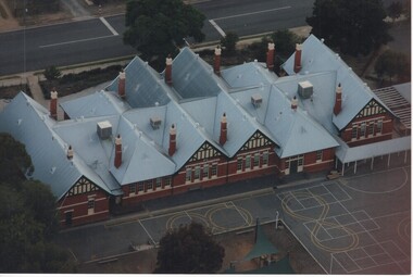 Rutherglen Historical Society
Photograph - Aerial Images, c2000
Photograph was probably taken sometime before 2007, as another photo in this series does not show the "Big Red Shed" behind the school. That building is shown on Google Street View shots taken in 2007. Rutherglen Common School No. 522, which is now the Common School Museum, would be to the left of the current school in the photo.Colour aerial photograph of Rutherglen Primary School No. 522, showing the rear of the building and its rooftop.rutherglen primary school, rutherglen state school, school buildings -
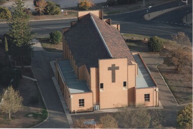 Rutherglen Historical Society
Photograph - Aerial Images, c2000
View is of the rear of St Mary's Catholic Church, RutherglenColour aerial photograph of the rear of the Catholic Church in Rutherglenst marys church, church buildings, churches -
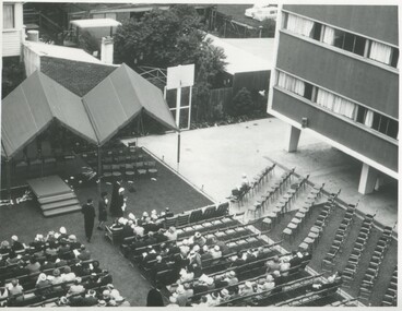 International House, The University of Melbourne
Photograph (Item), Aerial view of the official opening of the Samuel Wadham Wing at International House, 1963
... Aerial view of the official opening of the Samuel Wadham... Parade Parkville melbourne Photograph Aerial view of the official ...The Samuel Wadham Wing was the second purpose-built accommodation building at International House at the University of Melbourne. The building was officially opened by Lord Richard Casey (1890–1976) on 23 March 1963. -
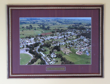 South Gippsland Shire Council
Photograph, Framed, Aerial town view of Mirboo North, 2004
... Aerial town view of Mirboo North... gippsland Photograph, Framed Aerial town view of Mirboo North One ...One of a set of two. Framed colour photograph titled: "Mirboo North Township 2004". Features an aerial photograph of the township of Mirboo North. Set in maroon card window mount and decorative brown and gold wood frame. Engraved brass text panel with white lined border affixed below image. -
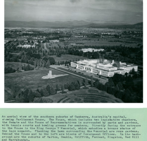 Department of Health and Human Services
An aerial view of the Southern suburbs of Canberra, Australia's Capital showing Old Parliament House circa 1958 - Department of Health – National Fitness Office (Sports & Recreation) – Historical Press Release Photo Collection
... An aerial view of the Southern suburbs of Canberra... Melbourne melbourne An aerial view of the Southern suburbs ...Department of Health – National Fitness Office (Sports & Recreation) – Historical Press Release Photo - Empire Youth Day & Royals on Tour CollectionDepartment of Health – National Fitness Office (Sports & Recreation) – Historical Press Release Photo - Empire Youth Day & Royals on Tour Collection -
 Department of Health and Human Services
Photograph, Ariel view Colanda grounds (circa 2000)
The Colac, Victoria-based Colanda Centre was one of the last Victorian institutions and offered disability accommodation from 1976, when it was established, until 2019, with its closure. Digitised colour aerial photograph of the Colanda Centre in Colac, Victoria. colanda, colac, disability services, residential services, disability, aerial photograph, digitised photograph -
 Department of Health and Human Services
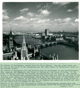
An aerial view with the Houses of Parliament & Big Ben on left of photo August 1957 - Department of Health – National Fitness Office (Sports & Recreation) – Historical Press Release Photo Collection
... An aerial view with the Houses of Parliament & Big Ben on... Melbourne melbourne An aerial view with the Houses of Parliament ...Department of Health – National Fitness Office (Sports & Recreation) – Historical Press Release Photo - Empire Youth Day & Royals on Tour CollectionDepartment of Health – National Fitness Office (Sports & Recreation) – Historical Press Release Photo - Empire Youth Day & Royals on Tour Collection -
 Department of Health and Human Services
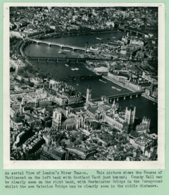
An aerial view of London's River Thames, The Houses of Parliament, and Big Ben - Department of Health – National Fitness Office (Sports & Recreation) – Historical Press Release Photo Collection
... An aerial view of London's River Thames, The Houses of... Melbourne melbourne An aerial view of London's River Thames ...Department of Health – National Fitness Office (Sports & Recreation) – Historical Press Release Photo - Empire Youth Day & Royals on Tour CollectionDepartment of Health – National Fitness Office (Sports & Recreation) – Historical Press Release Photo - Empire Youth Day & Royals on Tour Collection -
 Department of Health and Human Services
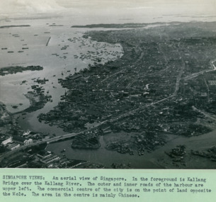
An aerial view of with the Kallang Bridge over the Kallang River in the foreground left Singapore - 3 of 3 photos - Department of Health – National Fitness Office (Sports & Recreation) – Historical Press Release Photo Collection
... An aerial view of with the Kallang Bridge over the Kallang... Melbourne melbourne An aerial view of with the Kallang Bridge over ...Department of Health – National Fitness Office (Sports & Recreation) – Historical Press Release Photo - Empire Youth Day & Royals on Tour CollectionDepartment of Health – National Fitness Office (Sports & Recreation) – Historical Press Release Photo - Empire Youth Day & Royals on Tour Collection -
 Port Melbourne Historical & Preservation Society
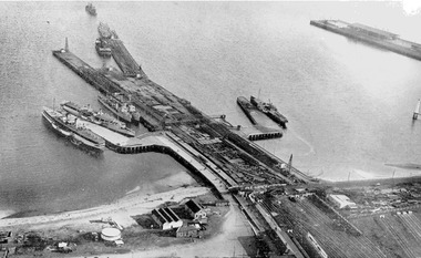
Photograph - Aerial view during construction of Station Pier, Port Melbourne, c. 1925
... Aerial view during construction of Station Pier, Port...Aerial view during construction of Station Pier, Port ...Aerial photo showing the double-headed pier created by partially dismantled Railway Pier and partially built Station Pier, late 1920s. Also the new wing piers with paddlesteamers Hygeia, Weeroona and Ozone (latter being broken up), foreshore and railyards, and end of Princes Pier. Pasted on A4 paper printed with computer generated chequered border.transport - shipping, piers and wharves - station pier, piers and wharves - railway pier, ps weeroona, ps hygeia -
Port Melbourne Historical & Preservation Society
Photograph - Aerial view of Station Pier, Port Melbourne on completion, Port Melbourne, 1930
... Aerial view of Station Pier, Port Melbourne on completion...Aerial view of Station Pier, Port Melbourne on completion ...Aerial photo of Station Pier on completion, 1930. Three colliers 'laid up' on east side and Weeroona (east) and Hygeia (west) laying at the wing piers. Shows the area set aside for Centenary Bridge.centenary bridge, melbourne harbor trust - port of melbourne authority, piers and wharves - station pier, transport - shipping, engineering - bridges, dumosa - collier, werribee - collier, ashridge - collier, ps weeroona, ps hygeia, transport - ferries -
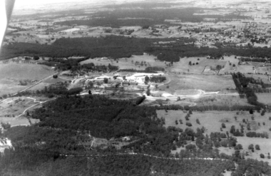
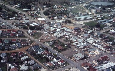
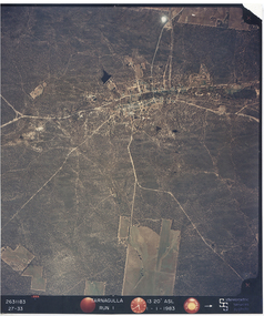 Tarnagulla History Archive
Photograph: Aerial view of Tarnagulla and district, 11th November 1983
... Photograph: Aerial view of Tarnagulla and district... Commercial Rd Tarnagulla goldfields Photograph: Aerial view ...Donald Clark Collection. An aerial colour photograph of Tarnagulla and surround lands. Labelled Run 1.tarnagulla -
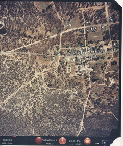 Tarnagulla History Archive
Photograph: Aerial view of Tarnagulla, 11th November 1983
... Photograph: Aerial view of Tarnagulla... Commercial Rd Tarnagulla goldfields Photograph: Aerial view ...Donald Clark Collection. An aerial colour photograph of Tarnagulla township. Labelled Run 3.tarnagulla -
 International House, The University of Melbourne
Photograph (Item), Aerial view of a young man standing on the front pathway at the main entry to International House
... Aerial view of a young man standing on the front pathway at...Photograph Aerial view of a young man standing on the front ... -
Stawell Historical Society Inc
Photograph - Large Print, Aerial View of Pleasant Creek Training Centre and North Western Woolen Mills, c1975
... Aerial View of Pleasant Creek Training Centre and North...Large Print Photograph Aerial View of Pleasant Creek ...Taken when buildings were at their peak. Referred to as Pleasant Creek Training Centre or Pleasant Creek Special SchoolMainly yellow coloured with Pleasant Creek Training Centre in middle and with Stawell North Western Woolen Mills at top right.VIC 25996 A1x10.3 QASCO VIC IMAGE 03 9682 3330education, manufacturing -
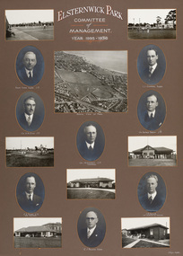 Bayside Gallery - Bayside City Council Art & Heritage Collection
Photograph - gelatin silver photograph, H. Singer, Elsternwick Park Committee of Management 1935-36, 1936
... Aerial view... Councillor Aerial view Golf Croquet Club house H. Singer ...elsternwick park, tennis, football, hockey, playground, sports pavilion, club, ralph tyner, l.l. chapman, cr. g.a. giles, cr. eustace tracey, cr. j.a. kennedy, chairman, cricket, c.e. tuxen, engineer, j.h. taylor, town clerk, treasurer, c.j. pollock, councillor, aerial view, golf, croquet, club house -
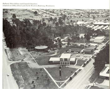 Federation University Historical Collection
Book, Progress in the Shire of Ballarat, 1963
... ballarat aerial view... plaster ballarat aerial view victorian inland meat authority s.k ...Pink covered book showing the Council Offices of the Shire of Ballaratballarat, shire of ballarat, ballarat shire council, brown, george powell, learmonth shire hall, cobb & co, learmonth, ballarat townscape, australian timken, wendouree west housing estate, wendouree west, ballarat airport, joe white maltings, alfredton, a.v. wehl industries, begonia house, walton, valenite-modco, sec substation, ballarat agricultural and pastoral society, gong gong, wendouree sewerage teatment works, alfredton recreation and sports centre, wendouree west library, wendouree recreation reserve, wendouree youth club, norton villiers, planning scheme, lucas textiles, immunizaton, kelaston, linda brown pre-school, wendouree pre-school, parklands clinic, alfredton infant welfare centre, darriwell park, vitclay pipes, t.m. burke estate, webbcona estate, franklin caravans, lake burrumbeet, forrest street primary school, ballarat high school, wendouree west state school, coronet industries, wendouree primary school, learmonth presbyterian church, st matthew's wendouree, st mary's redemptorist fathers monastery, robert ritchie, robert ritchie foodstores, stan farquhar, berklee products, ballarat golf course, s. j. weir, dowling forest racecourse, norm doodt, hines plaster, ballarat aerial view, victorian inland meat authority, s.k. mcivor, j. & g. dart, wendouree west aerial view, egg and egg pulp marketing board, councillors, kinnersly, giot, powell, sansom, cornell, edmonston, crick, ford, mitchell, cobb & co, j. g. dart, rex hollioake, mcdonald, baird, cobb & co, j. & g. dart -
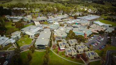 Federation University Historical Collection
Photograph, Aerial View of Gippsland Campus, 07/06/2017
... Aerial View of Gippsland Campus...Photograph Aerial View of Gippsland Campus Photograph ...In 1989 Monash University took over the Gippsland Institute of Advanced Education to create Monash Gippsland Campus. In 2014 the University of Ballarat and the Churchill Campus of Monash University merged to become Federation University Australia.Photograph of the Federation University Gippsland Campuschurchill, aerial, gipps, gippsland campus -
Glenelg Shire Council Cultural Collection
Photograph - Photograph - Aerial view of CSR Softwoods plant, Portland, c. 1974
... Photograph - Aerial view of CSR Softwoods plant, Portland... Cliff Street Portland great-ocean-road Photograph - Aerial view ...Port of Portland CollectionFront: (no inscriptions) Back: (no inscriptions)port of portland archives, aerial photography, portland harbour -
![Painting, untitled [Portland Port], n.d](/media/collectors/4f729f5597f83e03086015b1/items/655a82f77f3f3810362edb30/item-media/655a83847f3f3810362ef766/item-fit-380x285.jpg) Glenelg Shire Council Cultural Collection
Glenelg Shire Council Cultural CollectionPainting, untitled [Portland Port], n.d
Art Collection Previously located in History HouseThe painting depicts the Portland Port from an aerial perspective. The perspective is taken from the ocean looking down across the Port and into the town of Portland. Within the foreground is the ocean beyond the Main Breakwater, the Main Breakwater and the Port. Within the Port nine large ships are docked and another is being brought into the Port by two tugboats. The background features a distant view of the town of Portland and the landscape beyond the township. The work has a white wooden frame and glass.Front: TROMPF (white paint, bottom right corner) Back: (no inscriptions) -
Glenelg Shire Council Cultural Collection
Photograph - Photograph - aerial view of Portland harbour, n.d
... Photograph - aerial view of Portland harbour... Cliff Street Portland great-ocean-road Photograph - aerial view ...Port of Portland Authorityport of portland archives, aerial photography, portland harbour -
Glenelg Shire Council Cultural Collection
Photograph - Photograph - View of Port of Portland, 21/03/1972
Port of Portland Authority archives.Front: (no inscriptions) Back: 21/3/1972port of portland archives, portland harbour, cape nelson road, canal, railway, canal court, henty park -
Glenelg Shire Council Cultural Collection
Photograph - Photograph - aerial view of Portland harbour, n.d
... Photograph - aerial view of Portland harbour... Cliff Street Portland great-ocean-road Photograph - aerial view ...Port of Portland AuthorityBack: P.12,(iii) black biro 16/17 - black biro 15/1.2 - blue biroport of portland archives, aerial photography, portland harbour