Showing 15881 items
matching areas
-
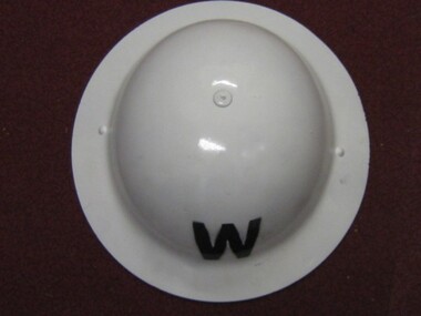 Running Rabbits Military Museum operated by the Upwey Belgrave RSL Sub Branch
Helmet
WW2 Air Raid Wardens,Area controller Helmet (reporo)headgear, ww2 -
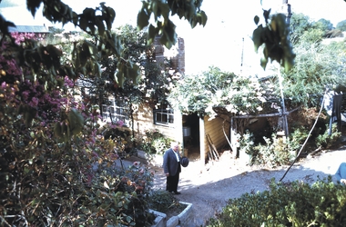 Bendigo Historical Society Inc.
Slide - MALDON & SURROUNDING AREAS, Apr 1968
Slide. Maldon & Surrounding Areas. A Man and friend in the backyard garden.slide, maldon & surrounding areas., maldon & surrounding areas. -
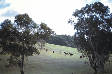 Bendigo Historical Society Inc.
Slide - MALDON & SURROUNDING AREAS, Apr 1968
Slide. Maldon & Surrounding Areas. Cattle grazing in a paddock on a hill.slide, maldon & surrounding areas., maldon & surrounding areas. -
 National Vietnam Veterans Museum (NVVM)
Audio - Audio, Casette, National Anthem (God Save the Queen). National tune (Advance Australia Fair)
Played by The East Australia Area Band of the Royal Australian Navy.audio, casette -
Tatura Irrigation & Wartime Camps Museum
Book, A School on the Wide Red Plain, 1976
Written to commemorate Centenary of Girgarre East School No. 1732Pale blue cover. Black writing. Area map of district. girgarre east school, centenary of girgarree east school, schools in victoria -
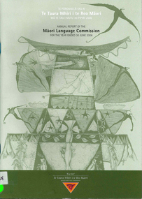 Victorian Aboriginal Corporation for Languages
Report, Maori Language Commission, Annual report of the Maori Language Commission for the year ended 30 June 2006, 2006
Bi-Lingual report into a variety of areas of Moaori Language Maintenance.maori culture, bilingualism -
 Victorian Aboriginal Corporation for Languages
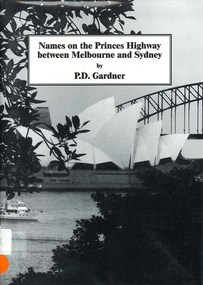
Book, P D Gardner, Names on the Princes Highway between Melbourne and Sydney : their origins, meanings and history, 2000
Place name list in a specific area. Giving descriptions and meanings.Maps, b&w illustrationsdandenong, genoa, south coast nsw, yarra river, moruya, kiama, captain cook, east gippsland, rosedale -
 Stawell Historical Society Inc
Memorabilia - Realia
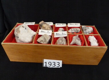
Prospecting Samples from All Nations Mine Stawell Areastawell -
Whitehorse Historical Society Inc.
Article, Know your city, 197-?
Places of interest in Nunawading. Describes early pioneers and properties in the area.Places of interest in Nunawading. Describes early pioneers and properties in the area.Places of interest in Nunawading. Describes early pioneers and properties in the area.antonio park mitcham, city of nunawading, schwerkolt cottage, slater, william, burwood east primary school no. 454, mcclelland, john, witt, william, tally ho boys home, stanley works pty ltd -
Whitehorse Historical Society Inc.
Document, Statistics relating to the City of Nunawading, 1963
Statistics of selected years of the Nunawading area from 1866 - 1963.Statistics of selected years of the Nunawading area from 1866 - 1963.Statistics of selected years of the Nunawading area from 1866 - 1963.statistics, city of nunawading, population, shire of blackburn and mitcham, shire of nunawading, nunawading district roads board -
 Whitehorse Historical Society Inc.
Photograph, East End of Museum and Implement Display, 15/09/2002 12:00:00 AM
Coloured photograph of the east end of the Museum and the Implement display area.schwerkolt cottage & museum complex -
 Whitehorse Historical Society Inc.
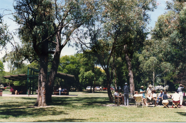
Photograph, Antonio Park, 1980's
Coloured photograph of picnic area at Antonio Park in the 1980'santonio park, mitcham -
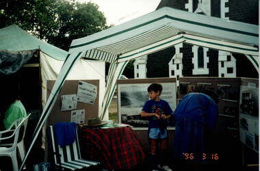
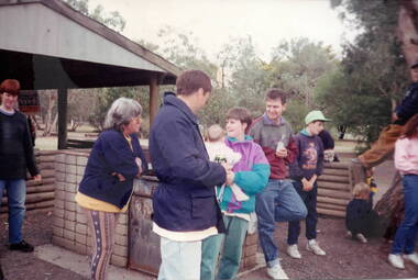
 Hume City Civic Collection
Photograph, Sunbury Fair, 16th March 1996
The people are looking at a photographic display mounted by the former members of the Sunbury & District Heritage Association. The event was the Sunbury Fair, which was staged on the Sunbury Village Green every year in March. A parade through the town took place in the morning and in the afternoon, community groups mounted displays on the Village Green. The Sunbury Fair was a popular community annual event that had wide support in the town.A coloured photograph of people looking at a display of photographs in an outdoor area.sunbury fair, sunbury & district heritage association, village green -
 Hume City Civic Collection
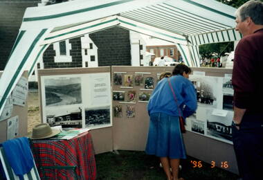
Photograph, Sunbury Fair, 16th March 1996
The people are looking at a photographic display mounted by the former members of the Sunbury & District Heritage Association. The event was the Sunbury Fair, which was staged on the Sunbury Village Green every year in March. A parade through the town took place in the morning and in the afternoon community groups mounted displays on the Village Green.The Sunbury Fair was a popular annual community event amongst the townspeople.A coloured photograph of people looking at a display of photographs in an outdoor area.sunbury fair, village green, sunbury & district heritage association -
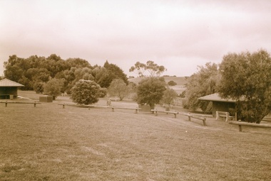 Department of Health and Human Services
Photograph, Colanda Grounds - Barbeque picnic area
The Colac, Victoria-based Colanda Centre was one of the last Victorian institutions and offered disability accommodation from 1976, when it was established, until 2019, with its closure.Digitised colour photograph of the Colanda Centre barbecue picnic area colanda, colac, disability services, residential services, disability, digitised photograph -
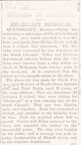 Queenscliffe Maritime Museum
Memorabilia - News clipping July 1931 Opium Found Queenscliffe, Opium found at Queenscliffe 1931, 1985
contrabandOpium find at Queenscliffea collection of news articles about the area around Port PhillipReverse " NIL "historical references -
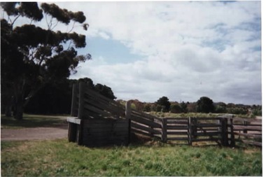 Sunbury Family History and Heritage Society Inc.
Photograph, 2001
The cattle yard was the pound used by the former Shire of Bulla. It is located in Cornish Street, Sunbury. The former pound is one of the few existing constructions seen in Sunbury, which came under the control of the former Shire of Bulla. A coloured photograph of a fenced cattle yard with a ramp in an open area.council pound., shire of bulla, sunbury -
 Sunbury Family History and Heritage Society Inc.
Photograph, School activities day and barbecue
The photograph was taken when the Bulla Primary School was having an activities day with students, staff and parents participating in the event. It took place within the attractive restored school grounds.The former Bulla Primary School included many activities in its curriculum that involved the community. A coloured photograph of children and adults gathered around a picnic area.activities days, bulla primary school -
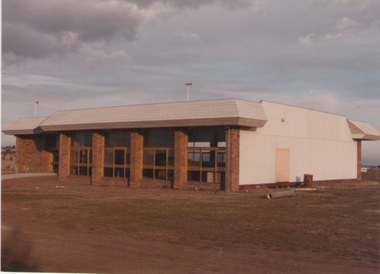 Sunbury Family History and Heritage Society Inc.
Photograph, c1980s
The recently completed building in the photograph is the Sunbury United Sporting Club's clubrooms, which is in Mitchells Lane, Sunbury. It was built for the local Sunbury soccer club in the 1980s. Along with VFL football, soccer is also a popular game in Sunbury.A coloured photograph of a recently built sports pavilion in an open area.sunbury united sporting club., soccer -
University of Melbourne, Burnley Campus Archives
Photograph - Black and white print, 491A/7
Students working among young fruit trees? In Agrostology area.students, fruit trees, agrostology, e. m. gibson collection -
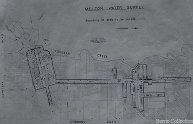 Melton City Libraries
Map, Melton Water Supply, Unknown
The development that had arguably the greatest impact in encouraging population growth in the shire during this period, was the establishment of a reliable water supply for the district. This had been a major concern of the local community for over 100 years, since the Melton township was first founded. Despite various schemes over the years to create a reliable water supply, the district was still dependent on bores, wells and tanks when the Melton Waterworks Trust was established in 1961 to address Melton’s water woes. With the opening of the Djerriwarrh Dam in December 1963, the shire’s residents finally had access to a reticulated water supply.Map shows the boundary of the area where the water will be serviced in the towncouncil -
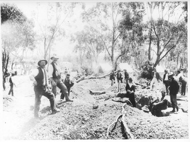 Tarnagulla History Archive
Photograph: Men in a mining area, Men in a mining area, circa 1850 to 1920
Murray Comrie Collection. This is a dark copy of an older original. Copy probably made by Murray Comrie in the 1960s.Monochrome photograph depicting men in a mining area in or near Tarnagulla.mining, miners, gold -
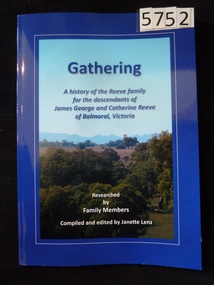 Stawell Historical Society Inc
Book, Janette Lenz, Gathering A History of the Reeves Family History, 2013
A History of the Reeve family for the descendants of James George and Catherine Reeve of Balmoral. Researched by family members.Two toned blue cover with a colour photo of Balmoral Area.Gathering A History of the Reeve family for the descendants of James George and Catherine Reeve of Balmoral, Victoria. Researched by Family Members Compiled and edited by Janette Lenzstawell, family hostory -
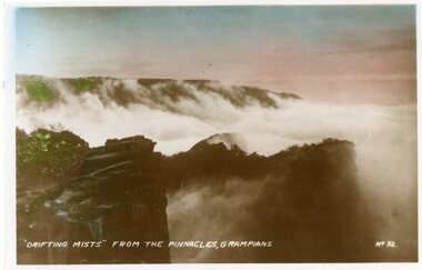 Stawell Historical Society Inc
Postcard, Drifting Mists from the Pinnacle in the Grampians -- Postcard
Drifting Mists from the Pinnacle No 32 The GrampiansColoured photograph of mountains with mist drifting over the mountain areas."Drifting Mist" from the Pinnacles, Grampians No 32halls gap grampians -
City of Kingston
Photograph - Black and white, 20 December 1945
This aerial image covers a section of Cheltenham, with a large paddock yet to be converted to an industrial and later a commercial zone.This aerial photograph provides evidence of the changing landscape of Cheltenham and Highett since WWII. Photographed in 1945, the image features a large block of land now the site of site the major transformation of Cheltenham with the development of the Southland shopping centre in the 1960s and expansion in the 1990s.Aerial photograph of the Cheltenham area in the City of Kingston. This 1945 image is concentrated on the area between Bay Road and Garfield Lane with the distinctive bend into Jean Street. A large block of land runs between the Nepean Highway and the rail line. This is now the area occupied by the extension of Southland in the 1990s. It is a negative version of VKHC124.cheltenham, southland, market garden -
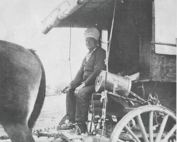 Wodonga & District Historical Society Inc
Photograph - Sikh Hawkers in Wodonga
Sikh hawkers were a regular sight throughout the Wodonga and Upper Murray district in the early 20th century. The regular visitors to the area included Pola Singh and Gambil (Gamble) Singh. Gamble Singh often camped on McKoy’s Moorefield property in West Wodonga and several other places around the district. Gamble was also a horse breeder and had several draught horses to pull his wagon. Like many of the hawkers he worked hard to send money back to support family in India. He apparently returned to India about 1950, but left some money in the Bank of NSW in Wodonga in case he returned. He allegedly died soon after and the money was eventually able to be claimed by his nephews in India. A small overlooked park in Wodonga is named the “Gamble Singh Park” in his memory. J. Flanagan who operated the Halfway Hotel commented on having as many as seven or eight bullock teams “yoked” overnight to the fence outside the hotel as well as 100 or more Indian hawkers – led by the fondly known Pola (Pollah) Singh. The hawkers returned to Wodonga annually to renew their hawkers’ license and camped on the flats, or also came to Wodonga to collect orders at the railway station to stock up their supplies. Pola Singh was often based at the Colac Colac reserve near Corryong and had on board his compatriot Isar Singh. He often acted as an intermediary between the individual hawkers and the authorities. Unfortunately, it was Pola’s habit to walk in front of his wagon at the start of each day. On the morning of 23 June 1923 his horses were restive and hard to control. They took flight and ran Pola down on the road near Cudgewa. He was rushed to the Corryong Hospital but died there a few days later, aged 65. Pola was cremated, with some of his ashes scattered in the Murray River and some returned to his homeland to be scattered in the Ganges River. His cremation was listed in the Obituary page of the Weekly Times, Melbourne on Saturday 14 July 1923. A small memorial to Pola Singh is located in the Corryong Cemetery.These images are significant because they help to document the history of the Sikh Hawkers who plied their services to Wodonga and throughout rural Australia in the late 19th and early 20th centuries.A collection of black and white images featuring Sikh Hawkers Gamble Singh and Pola Singh take in the Wodonga area.indian hawkers, sikh hawkers, gamble singh, pola singh -
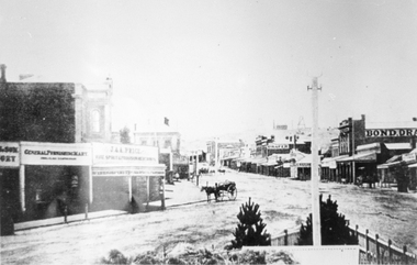 Stawell Historical Society Inc
Photograph, Main Street looking East from Coffee Palace area 1880
Main Street Looking East 1880 from weigh bridge area, taken from Coffee Palace verandah. Two story buildings with veranda's. Horse drawn vehicle center of image. Post office and Town Hall visible in background. Bond Drapery. J & A Price Wine Spirits. Bond Draper sign on right. Two Poppet Heads on Big Hill are the No2 North Waterloo and the Waterloo and Argyle Mines.Black and white photograph looking East along Main Street from Weighbridge area where two streets join. Horse drawn buggy in center of street with buggy. Big Hill in distance with two poppet heads just visible.stawell businesses streetscape -
Whitehorse Historical Society Inc.
Map, Melbourne Geological Map, 1937
Geological Map of Melbourne & Suburbs.Geological Map of Melbourne & Suburbs. Scale: 40 chains to 1 inch with inset 10 miles to 1 inch. Includes Municipal and Parish boundaries, railways and stations, electric tramways, cable tramways, Post Offices and State schools. Area bounded by Braybrook, Preston, Blackburn & Brighton. Printed on linen.Geological Map of Melbourne & Suburbs. melbourne, maps -
 City of Moorabbin Historical Society (Operating the Box Cottage Museum)
Photograph - Map of Dendy's Special Survey, 1852 Map of Henry Dendy's Special Survey of 1841, 19th Century
A Map drawn in 1852 that shows the 5,120 acres that formed Dendy's Special Survey of 1841. In 1840 Henry Dendy, a farmer in Surrey, England acquired a "Special Survey" from the Commissioners for Land and Emigration which gave Dendy the right to choose land in Port Phillip for the "bargain basement" price of only £1 per acre for 5120 acres, (an area of 8 square miles). The Special Survey also included the right to "the shipment of a worker for every £20 spent on land, whose free passage was paid by the Crown, equalling a total of 100 workers ". Accordingly Dendy sold his English holdings and paid the required £5120 and arrived in Melbourne in February 1841. However by this time land in the new colony was selling for £5 - £40 per acre. Because Henry Dendy possessed the order from the Colonial Office in London he was able to successfully oppose Governor LaTrobe's attempts to alter the price of the land. Dendy appointed Jonathan Were, (an entrepreneur, who had arrived in 1839), as his Manager and who later became a partner. Together, Dendy and Were decided on an area 5 miles south from Melbourne, bounded by North Road, East Boundary Road, South Road and to the west by Port Phillip Bay. Were and Dendy pitched their tents in the area now known as ' Park St, Brighton' and sank a well near the corner of 'St Andrew's St and Wells St'. By 1845 J.B Were and Company had bought almost half of Dendy's land and Were built himself "Moorabbin House" in Were St Brighton made from stone, quarried from local cliffs. It was still standing in 1924. Legend records Moorabbin is named after the Aboriginal word for ' Mother's Milk ' The soil is very fertile and well supplied with water especially in the area called 'East Brighton' - now known as Bentleigh and East Bentleigh - By 1850 the area had developed with numerous market gardens, dairy farms, fruit gardens and vineyards supplying food for the growing population of Melbourne.This Map shows the birth of the Brighton and Moorabbin area. On 18th January1859 Brighton was proclaimed a Municipality and a Borough by October 1863. Meanwhile, following a Petition, the area of East and South Brighton, incorporating Mordialloc, Cheltenham, Mentone, Sandringham and Oakleigh separated from Brighton to form the Moorabbin District Roads Board becoming the first Local Government Authority. Col. William Mair was elected as the first Chairman of the Moorabbin Roads Board. Moorabbin Shire 1871 developed further and was declared a City in1934. The City of Moorabbin was the largest Municipality in Melbourne before the Amalgamation of Councils in 1994 when it was divided in the south to City of Kingston and in the north to City of Glen Eira A Photo-lithographed 1852 Map showing the 5,120 acres that formed Dendy's Special Survey of 1841. Henry Dendy & Jonathan Were chose an area 5 miles south from Melbourne, bounded by North Road, East Boundary Road, South Road and to the west by Port Phillip Bay. Moorabbin County of Bourke / Photo-Lithographed at the department of Lands and Survey. /Melbourne. / Price 1/- brighton, moorabbin, bentleigh, cheltenham, dendy henry, bent thomas, were jonathan, special survey -
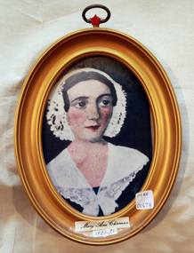 City of Moorabbin Historical Society (Operating the Box Cottage Museum)
Print - Mary Ann Charman 1820 - 1870
Mary Ann Charman was a pioneer settler in the Cheltenham area of the Parish of Moorabbin c1850 Stephen Charman , who emigrated in 1942 as a Henry Dendy employee aged 21 years, sadly lost his wife and child shortly after arriving in Brighton. When Dendy could not employ him he found other work. In 1850 he met Mary Gettens a widow with 5 children who supported her family by managing her late husband’s Inn in Collins St. Melbourne. Stephen purchased land in Spring Grove, now Cheltenham, in 1852 and the family moved to the wattle and daub hut after their marriage. Mary and Stephen worked very hard to establish a market garden, poultry and pork farm . They specialised in Marigolds which they sold to Martin & Pleasance Pharmacy , Melbourne for medicinal purposes. Mary and Stephen had 7 more children and Mary still managed to find time to sell the pork, poultry and vegetables from a horse drawn cart she drove around St Kilda. 1857 Stephen donated land to the Methodist Church for a School, burial ground and Chapel in Balcombe Road. Mary died 1870. Stephen remarried in 1878 and died aged 85 years 1906. Charman Road runs from Nepean Highway , Cheltenham through Beaumaris to the Beach Road at Mentone. Mr Les Jones was the Great Grandson of Mary Ann CharmanAn oval framed colour copy of a painting of the likeness of Mary Ann Charman, 1820 - 1870 pioneer settler in the Cheltenham area of the Parish of Moorabbinpioneers, early settlers, dendy henry, charman mary ann, jones les, cheltenham, moorabbin, brighton, market gardeners, dairy farmers, charman road