Showing 33208 items matching "buildings/streetscapes"
-
 Port Melbourne Historical & Preservation Society
Photograph - Magnolia, 75 Evans Street, Port Melbourne, Meredith Turnbull, Dec 1996
Meredith Turnbull photographed this series in 1996 to record the rapidly changing streetscape, which had already had a number of old houses replaced by concrete two-storey structures under the State government's urban consolidation policyFrom a series of 70 colour photos recording all buildings in Evans Street from Graham Street overpass to Ingles Street, as photographed from the railway reservation, by Meredith TURNBULL in December 1996 - number 75, 'Magnolia' (once home of Phillip SALMON) -House numbers noted on backbuilt environment - domestic, meredith turnbull, phillip melville salmon -
Port Melbourne Historical & Preservation Society
Photograph - 85 & 86 Evans Street, Port Melbourne, Meredith Turnbull, Dec 1996
Meredith Turnbull photographed this series in 1996 to record the rapidly changing streetscape, which had already had a number of old houses replaced by concrete two-storey structures under the State government's urban consolidation policyFrom a series of 70 colour photos recording all buildings in Evans Street from Graham Street overpass to Ingles Street, as photographed from the railway reservation, by Meredith Turnbull in December 1996 - number 85, 86 (corner shop at Bridge Street)House numbers noted on backbuilt environment - domestic, meredith turnbull -
Port Melbourne Historical & Preservation Society
Photograph - 141 Evans Street (Raglan Street Housing Commission flats), Port Melbourne, Meredith Turnbull, Dec 1996
Meredith Turnbull photographed this series in 1996 to record the rapidly changing streetscape, which had already had a number of old houses replaced by concrete two-storey structures under the State government's urban consolidation policyFrom a series of 70 colour photos recording all buildings in Evans Street from Graham Street overpass to Ingles Street, as photographed from the railway reservation, by Meredith Turnbull in December 1996 - number 141 - Raglan Street Housing Commission flatsHouse numbers noted on backbuilt environment - domestic, built environment - public housing, meredith turnbull -
 Sunbury Family History and Heritage Society Inc.
Photograph, c.1910
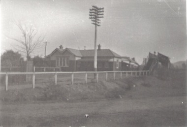
The building in the photograph is the Sunbury Railway Station in Brook Street and before it underwent renovations and externaL changes.The establishment of the railway in Sunbury in 1859 was an important development in the town's history and fore the Bendigo regional rail network.A black and white photograph of a weatherboard building behind a post and rail fence with a tall power pole in front of the building. A roadway is in front of the building.sunbury railway station -
 Rutherglen Historical Society
Postcard, 1910-1920 (Approximate)
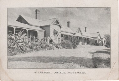
Unframed black and white photograph of a long weatherboard building with verandas across much of the front.Printed below photograph: "Viticultural College Rutherglen" On message side of postcard: "Secretary, Soldiers' Fathers' Assn., Manufacturers' Building, 312 Flinders St., Melbourne."viticultural college -
 Kew Historical Society Inc
Plan, Melbourne & Metropolitan Board of Works : Borough of Kew : Detail Plan No.1568, 1905
The Melbourne and Metropolitan Board of Works (MMBW) plans were produced from the 1890s to the 1950s. They were crucial to the design and development of Melbourne's sewerage and drainage system. The plans, at a scale of 40 feet to 1 inch (1:480), provide a detailed historical record of Melbourne streetscapes and environmental features. Each plan covers one or two street blocks (roughly six streets), showing details of buildings, including garden layouts and ownership boundaries, and features such as laneways, drains, bridges, parks, municipal boundaries and other prominent landmarks as they existed at the time each plan was produced. (Source: State Library of Victoria)This plan forms part of a large group of MMBW plans and maps that was donated to the Society by the Mr Poulter, City Engineer of the City of Kew in 1989. Within this collection, thirty-five hand-coloured plans, backed with linen, are of statewide significance as they include annotations that provide details of construction materials used in buildings in the first decade of the 20th century as well as additional information about land ownership and usage. The copies in the Public Record Office Victoria and the State Library of Victoria are monochrome versions which do not denote building materials so that the maps in this collection are invaluable and unique tools for researchers and heritage consultants. A number of the plans are not held in the collection of the State Library of Victoria so they have the additional attribute of rarity.Original survey plan, issued by the MMBW to a contractor with responsibility for constructing sewers in the area identified on the plan within the Borough of Kew. The plan was at some stage hand-coloured, possibly by the contractor, but more likely by officers working in the Engineering Department of the Borough and later Town, then City of Kew. The hand-coloured sections of buildings on the plan were used to denote masonry or brick constructions (pink), weatherboard constructions (yellow), and public buildings (grey). Plan No.1568 covers the area bounded by Cotham Road, John Street, Sackville Street, and Edward Street. Alfred Street and Rowland Street are in shown in the middle of the plan. The two most notable buildings shown are ‘St Helliers’, the home of the Dumaresq family, and St Hilary’s Church and school. While the colours used to indicate St Hilary’s are grey as in other civic/public buildings, the first St Hilary’s Anglican Church was at this stage constructed in weatherboard. At the left of the plan, facing Sackville Street is a house named ‘Glencara’. The 1988 ‘Kew Conservation Study’ recorded that “The first documentary evidence of this house comes from Rate Books which record that in 1893 a Mrs Treadway was the owner of this building with an N.A.V. of £81? At that date the occupier of the house was Charles B. Kelly, a clerk, while by 1910 Kelly had become the owner of the property described in that year ‘as a six-roomed stone, brick and wood house with stables and outbuildings’”. Contrary to this description, the 1905 plan indicates that the house was entirely constructed of masonry.melbourne and metropolitan board of works, detail plans, mmbw 1568 -
 Kew Historical Society Inc
Plan, Melbourne & Metropolitan Board of Works : Borough of Kew : Detail Plan No.1573, 1905
The Melbourne and Metropolitan Board of Works (MMBW) plans were produced from the 1890s to the 1950s. They were crucial to the design and development of Melbourne's sewerage and drainage system. The plans, at a scale of 40 feet to 1 inch (1:480), provide a detailed historical record of Melbourne streetscapes and environmental features. Each plan covers one or two street blocks (roughly six streets), showing details of buildings, including garden layouts and ownership boundaries, and features such as laneways, drains, bridges, parks, municipal boundaries and other prominent landmarks as they existed at the time each plan was produced. (Source: State Library of Victoria)This plan forms part of a large group of MMBW plans and maps that was donated to the Society by the Mr Poulter, City Engineer of the City of Kew in 1989. Within this collection, thirty-five hand-coloured plans, backed with linen, are of statewide significance as they include annotations that provide details of construction materials used in buildings in the first decade of the 20th century as well as additional information about land ownership and usage. The copies in the Public Record Office Victoria and the State Library of Victoria are monochrome versions which do not denote building materials so that the maps in this collection are invaluable and unique tools for researchers and heritage consultants. A number of the plans are not held in the collection of the State Library of Victoria so they have the additional attribute of rarity.Original survey plan, issued by the MMBW to a contractor with responsibility for constructing sewers in the area identified on the plan within the Borough of Kew. The plan was at some stage hand-coloured, possibly by the contractor, but more likely by officers working in the Engineering Department of the Borough and later Town, then City of Kew. The hand-coloured sections of buildings on the plan were used to denote masonry or brick constructions (pink), weatherboard constructions (yellow), and public buildings (grey). This plan has detailed annotations written in red or blue ink, showing prices, which may be the annual valuations of the properties, and some owners’ names, a most unusual feature on contractor's maps. Some areas, such as the buildings of Methodist Ladies’ College (MLC), include the school’s tennis court and swimming pool, but are not coloured to show building materials – did the draftsman just run out of time, or ink, or enthusiasm, before his plan had to be submitted? MLC had been founded in 1882 as a ‘modern school of the first order’ with buildings that formed ‘a collegiate institution for girls unsurpassed in the colonies’. The goal of its founders was to provide a high-class Christian education for girls, comparable with that provided elsewhere for boys. Some shops are shown along Edgevale Road, though they are not designated as commercial premises. Larger houses are depicted, including ‘Fairlawn’ in Barkers Road, and ‘Clevedon’ and ‘Rosehill’ (now demolished) in Fitzwilliam Street.melbourne and metropolitan board of works, detail plans, mmbw 1573, maps - borough of kew, cartography -
Port Melbourne Historical & Preservation Society
Photograph - 64 Evans Street, Port Melbourne, Meredith Turnbull, Dec 1996
Meredith Turnbull photographed this series in 1996 to record the rapidly changing streetscape, which had already had a number of old houses replaced by concrete two-storey structures under the State government's urban consolidation policyFrom a series of 70 colour photos recording all buildings in Evans Street from Graham Street overpass to Ingles Street, as photographed from the railway reservation, by Meredith Turnbull in December 1996 - 64 Evans, Meredith's home (built by Caleb Kennett, 1872?House numbers noted on backbuilt environment - domestic, meredith turnbull -
Port Melbourne Historical & Preservation Society
Photograph - 135 & 137 Evans Street (Raglan Street Housing Commission flats), Port Melbourne, Meredith Turnbull, Dec 1996
Meredith Turnbull photographed this series in 1996 to record the rapidly changing streetscape, which had already had a number of old houses replaced by concrete two-storey structures under the State government's urban consolidation policyFrom a series of 70 colour photos recording all buildings in Evans Street from Graham Street overpass to Ingles Street, as photographed from the railway reservation, by Meredith Turnbull in December 1996 - - number 135, 137- Raglan Street Housing Commission flatsHouse numbers noted on backbuilt environment - domestic, built environment - public housing, meredith turnbull -
 Lake Bolac & District Historical Society
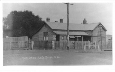
Photograph - Black and white photograph, Lake Bolac Post Office - Glenelg Highway Lake Bolac c.1940s, c1940
Lake Bolac Post Office Glenelg Highway. Initially the Post Office was established at the Store in 1868. This official weatherboard building was opened in 1887 incorporating a telegraph office, money order office and post office savings bank. The Post Office business was relocated in 1944 and the building was used as a private residence with the front room leased to Dennys Lascelles. Note the horse hitching rail and kerosene street light.Photograph depicting a weatherboard building across a road. The building is fenced. In front of the building there is a telegraphic or electric post and a lamp post.lake bolac, post office, glenelg highway, dennys lascelles -
Creswick Campus Historical Collection - University of Melbourne
Document, unknown
School of Forestry existing services and condition plans, Building plans. Extension plansBuilding Plans -
 Federation University Historical Collection
Photograph, Stained Glass Windows at the Ballarat School of Mines Administration Building, 2015, 07/10/2015
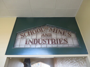
This leadlight window was originally over the door of the Administration Building on SMB Campus. Colour photograph of a stained glass window in the Ballarat School of Mines Administration Building (Building A).ballarat school of mines, administration building, new classrooms, stained glass, lydiard street south, ballarat, architectual features, a building -
 Kilmore Historical Society
Photograph, Oriental Bank Corporation, 1866
This photograph was most likely taken for the 1866 Intercolonial Exhibition in Melbourne.25cm x 20cm black and white reproduction of a photograph of the Oriental Bank Corporation, 7 Sydney Street Kilmore, from the State Library of Victoria. Double storey building with decorative parapet along roofline, wrought iron balconets at upper storey windows, decorative hood molds above windows, name of bank in stone under ground floor cornice, a man standing on path in front of bank. Woman standing at back of building in shadow. A sign on post at back of building reads: Land for Sale Apply to W. Grace Solicitor Kilmore.Printed on back: REPRODUCTION RIGHTS RESERVED Copied by State Library of Victoria Tenders called for erection of this building in March 1864.banks, 19th century -
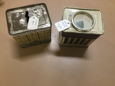 Yarrawonga and Mulwala Pioneer Museum
Money Box X 2
Tin - Produced by the Commonwealth Bank (Savings of Australia) . Two different patterns on the outside - appears to be of the bank building a) yellow & green colourings b) Maroon and yellow.On top on No 2- it has "This money box is a replica of the Commonwealth Bank Heritage Building 48 Marlin Place ,Sydney. -
Port Melbourne Historical & Preservation Society
Photograph - Gloucester House, Evans Street, Port Melbourne, Meredith Turnbull, Dec 1996
Meredith TURNBULL photographed this series in 1996 to record the rapidly changing streetscape, which had already had a number of old houses replaced by concrete two-storey structures under the State government's urban consolidation policyFrom a series of 70 colour photos recording all buildings in Evans Street from Graham Street overpass to Ingles Street, as photographed from the railway reservation, by Meredith TURNBULL in December 1996 - Farrell Street West and Gloucester House (once home of Wm PROHASKY)House numbers noted on backbuilt environment - domestic, meredith turnbull, william henry prohasky -
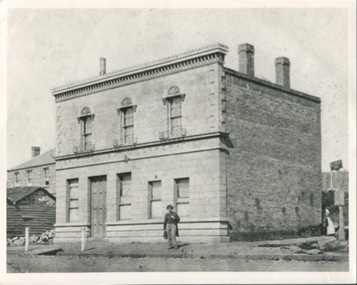
 Bendigo Historical Society Inc.
Photograph - PALL MALL SANDHURST , 1857, 1857
Sepia photograph of early Bendigo streetscape, Stone building in in forefront LH side, now View Street. In Pall Mall on left is the Shamrock Hotel, then the building that now houses the Bendigo Bank, in the centre is 23 the sign below possibly reads ELVTA, to the right is Edmonds Horse Bazaar, 2 doors to the right is the 2 story building that housed the Colonial Bank, beside that is Victoria Hotel then the stables which became Allan's walk. Markings/Inscriptions: none.place, streetscape, pall mall -
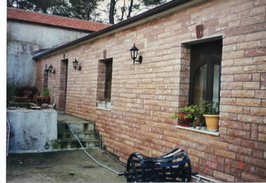 Ithacan Historical Society
Photograph, Panagias Monastery, Ithaca, Late
The photo shows a section of the brick building where repairs have been done to the windows along the side of the building. The older and original section of the monastery is in the background.A coloured photograph of a section of a cream brick building with the older section of the building in the background beyond the patio which is in need of repairs. -
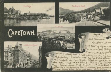 Bendigo Historical Society Inc.
Postcard - GLADYS DEAN COLLECTION: POSTCARD, 1906 - 1908
Printed black and white postcard. Images depict various views of Capetown. Clockwise from upper left is of a jetty with boats and buildings with the words The Jetty printed in red across the top. Next is a streetscape with buildings and trees with the words Tambours Kloof printed in red across the top. Next is an aerial view of a sea port with the words The Docks printed in red across the top. Finally a streetscape with buildings, horse drawn vehicles and people walking with the words Adderley Street printed in red across the top. The words Cape Town are printed in White on the left hand side. A white space depicted as a scroll is in the lower right hand corner containing handwriting. On reverse card is addressed to Mr G Balsillie Hopper St Bendigo Victoria Australia. Writing covers the left hand side.postcard -
 Kiewa Valley Historical Society
Photographs – Kiewa Cres Mt Beauty. Circa 1993. Set of 12 colour photographs
Established in 1946, during the construction of the Kiewa Hydro Electric Scheme, the township of Mt Beauty was developed by the State Electricity Commission of Victoria to provide additional accommodation for the thousands of workers during the construction of the country’s second largest hydro-electricity scheme. Although these towns were built as temporary accommodation for the workers and their families, many stayed after the scheme finished. Combined with the influx of European migrants, with their rich cultural backgrounds, all played a major part in shaping the future character of the Mount Beauty, the Kiewa Valley and Falls Creek. The Bright Council, now the Alpine Shire took over the control of the township in 1960. This relatively young town of Mount Beauty, along with the surrounding townships of Falls Creek, Bogong, Tawonga South and Tawonga, are all part of a prospering tourist area with excellent services, accommodation, food and a wide range of recreational activities available for all ages. According to Shire records, the population of Mt Beauty has grown from 1,500 in 1981 to 1,800 in 2016 with a projected increase to 2,000 in 2013The photographs taken around 1993 show a prosperous commercial centre catering for both locals and the needs of visitors. It provides a pictorial history of the changes which have occurred in the retail/commercial district of Mt Beauty over the years. It also demonstrates the attention paid by Alpine Shire towards providing accessible recreational green space around the town centre.Set of 12 colour photographs of Kiewa Cres Mt Beauty. Circa 1993 showing retail services and streetscape of the time. No markingskiewa cres mt beauty, mt beauty -
 Kiewa Valley Historical Society
Photographs – Lakeside Avenue, Mt Beauty. Circa 1993. Set of 7 colour photographs
Established in 1946, during the construction of the Kiewa Hydro Electric Scheme, the township of Mt Beauty was developed by the State Electricity Commission of Victoria to provide additional accommodation for the thousands of workers during the construction of the country’s second largest hydro-electricity scheme. Although these towns were built as temporary accommodation for the workers and their families, many stayed after the scheme finished. Combined with the influx of European migrants, with their rich cultural backgrounds, all played a major part in shaping the future character of the Mount Beauty, the Kiewa Valley and Falls Creek. The Bright Council, now the Alpine Shire took over the control of the township in 1960. This relatively young town of Mount Beauty, along with the surrounding townships of Falls Creek, Bogong, Tawonga South and Tawonga, are all part of a prospering tourist area with excellent services, accommodation, food and a wide range of recreational activities available for all ages. According to Shire records, the population of Mt Beauty has grown from 1,500 in 1981 to 1,800 in 2016 with a projected increase to 2,000 in 2013The photographs taken around 1993 show a prosperous commercial centre catering for both locals and the needs of visitors. It provides a pictorial history of the changes which have occurred in the retail/commercial district of Mt Beauty over the years. It also demonstrates the attention paid by Alpine Shire towards providing accessible recreational green space around the town centre.Set of 7 colour photographs of Lakeside Avenue, Mt Beauty. Circa 1993 showing retail services and streetscape of the time. No markingsmt beauty, lakeside ave mt beauty -
 Kiewa Valley Historical Society
Photographs – Tawonga Cres., Mt Beauty. Circa 1993. Set of 4 colour photographs
Established in 1946, during the construction of the Kiewa Hydro Electric Scheme, the township of Mt Beauty was developed by the State Electricity Commission of Victoria to provide additional accommodation for the thousands of workers during the construction of the country’s second largest hydro-electricity scheme. Although these towns were built as temporary accommodation for the workers and their families, many stayed after the scheme finished. Combined with the influx of European migrants, with their rich cultural backgrounds, all played a major part in shaping the future character of the Mount Beauty, the Kiewa Valley and Falls Creek. The Bright Council, now the Alpine Shire took over the control of the township in 1960. This relatively young town of Mount Beauty, along with the surrounding townships of Falls Creek, Bogong, Tawonga South and Tawonga, are all part of a prospering tourist area with excellent services, accommodation, food and a wide range of recreational activities available for all ages. According to Shire records, the population of Mt Beauty has grown from 1,500 in 1981 to 1,800 in 2016 with a projected increase to 2,000 in 2013The photographs taken around 1993 show a prosperous commercial centre catering for both locals and the needs of visitors. It provides a pictorial history of the changes which have occurred in the retail/commercial district of Mt Beauty over the years. It also demonstrates the attention paid by Alpine Shire towards providing accessible recreational green space around the town centre.Set of 4 colour photographs Tawonga Crescent, Mt Beauty. Circa 1993 showing retail services and streetscape of the time No markingstawonga cres mt beauty -
 Kiewa Valley Historical Society
Photographs – Kiewa Cres Mt Beauty. Circa 1993. Set of 12 colour photographs, circa 1993
Established in 1946, during the construction of the Kiewa Hydro Electric Scheme, the township of Mt Beauty was developed by the State Electricity Commission of Victoria to provide additional accommodation for the thousands of workers during the construction of the country’s second largest hydro-electricity scheme. Although these towns were built as temporary accommodation for the workers and their families, many stayed after the scheme finished. Combined with the influx of European migrants, with their rich cultural backgrounds, all played a major part in shaping the future character of the Mount Beauty, the Kiewa Valley and Falls Creek. The Bright Council, now the Alpine Shire took over the control of the township in 1960. This relatively young town of Mount Beauty, along with the surrounding townships of Falls Creek, Bogong, Tawonga South and Tawonga, are all part of a prospering tourist area with excellent services, accommodation, food and a wide range of recreational activities available for all ages. According to Shire records, the population of Mt Beauty has grown from 1,500 in 1981 to 1,800 in 2016 with a projected increase to 2,000 in 2013The photographs taken around 1993 show a prosperous commercial centre catering for both locals and the needs of visitors. It provides a pictorial history of the changes which have occurred in the retail/commercial district of Mt Beauty over the years. It also demonstrates the attention paid by Alpine Shire towards providing accessible recreational green space around the town centre.Set of 12 colour photographs Kiewa Cres Mt Beauty. Circa 1993 showing retail services and streetscape of the time. No markingskiewa crescent mt beauty; shopping centre; -
Federation University Historical Collection
Document - Report, Andrew Ward, Ballarat Heritage Review, 1998, 1998
... streetscapes ...City of Ballarat Heritage review including introduction and objectives, study area, summary of recommendations, significant streetscapes, and smaller towns.ballarat heritage study, ballarat, heritage, architecture, streetscapes, landscape importance, mining importance, addington, ascot, bald hills, buninyong, burnside, burrumbeet, coghill's creek, dowling forest, durham lead, glendaruel, learmonth, miners rest, mount blowhard, scotchman's lead, smythes creek, tourello, weatherboard, windermere, andrew ward -
![Painting, S.H. Raza, [Streetscape], 1977](/media/collectors/57a00a4fd0cdd1210422a51e/items/63e726a58b6b08140b576b30/item-media/63e728678b6b08140b57b643/item-fit-380x285.jpg) Ballarat Heritage Services
Ballarat Heritage ServicesPainting, S.H. Raza, [Streetscape], 1977
Framed streetscape with people in a shopping precinct. If you can provide information on this artist or artwork please use the link below. LRS G.H. Raza 77."painting, townscape, streetscape -
 Surrey Hills Historical Society Collection
Photograph, Trafalgar Street, Surrey Hills
... streetscapes ...This was taken to record part of the course of the former Surrey Hills Golf Club. The Surrey Hills Golf Club was founded by Mr Hugh W McLeod in 1894. The first president was Mr A W Harston. Mr William Meader was the first honorary secretary and the club champion for several years. Another notable identity was Mr. Harry Culliton, who contributed golf notes to "The Argus" for many years. As pressure for land for development grew, the club was forced to move. It eventually became the Riversdale Golf Club and its history is outlined in the book 'Riversdale Golf Club: a history 1892-1977' by John Arnold.A coloured photograph of a streetscape. A red brick house and fence can be seen on the one corner, street trees line the street.surrey hills, trafalgar street, nelson street, wolseley street, golf, 1997, streetscapes, 1902, mr george meader, first president of golf club, mr h w mcleod, mr a w harston, mr william meader, mr harry culliton, riversdale golf club, mr john arnold -
Clunes Museum
Painting - PAINTINGS, David Williams
Images of; Horse Trough & Wagon Residence 94 Bailey Street Former Presbytery St. Thomas Aquinas Former Clunes Free Library Residence 25 Camp Street Monument 100 years of gold Clunes in Melb Monument Former butcher's shop Fraser Street Residence & shops 41-43 Fraser Street Clunes School of Mines Clunes War Memorial Residence 32 Leslie St Clunes Former suspension bridge Former St Paul's Vicarage 42 Service Street Former Police Office Former Police residence Portable Lock Up Former Dow Residence 9 Hill St Former Hall & Fire Station 2 Hill St St Paul's timber Church hall St Paul's Church Masonic Lodge 23 Service St St Paul's Pulpit Masonic Lodge interior Everhard cordial bottles Scythes in Clunes Museum Ascot Blacksmith shop Former Ascot hotel MIA Hall Ascot The Coghill Monument Former Methodist Church Coghills Creek Clunes Cemetery Chapel Maiden Hill Homestead shearing shed Beckworth Court stables Beckworth Cour shearer's quarters Former School Evansford Glengower Outbuilding Amerst Former Mortuary 46-50 Fraser Street Wood fired heater Beckworth court farm shed Gold mine trolley Servant's bells Maiden Hill cow bail Former South Clunes school 29 George Street 70 Fraser Street Former Post Office "Allowah" Clunes Street Ascot "Homestead" Beackwith Court "The Meat House" Beckwith Court "Shearing Sheds" Beckwith Court Evansford Community Hall 54 watercolours remaining from the 2003 exhibition held at Clunes, all unframed, depicting Clunes and surrounds architecture and streetscapes.BY DAVID WILLIAMSwatercolour, 2003 exhibition -
 Clunes Museum
Painting
RICHARD FORD, CLUNES ARTIST, TEACHEROIL PAINTING IN A WOODEN FRAME BY RICHARD FORD. AN OLDER PERIOD STREETSCAPE OF CLUNES. POSSIBLY VIEWED FROM SCHOOL HILL.richard ford -
 Sunbury Family History and Heritage Society Inc.
Photograph, Royal Hotel, 1936
The building being demolished in the photograph is the Railway Hotel which was destroyed by fire in 1936. It was decided to demolish the old building and rebuild a more modern hotel on the Brook/Evans Street corner where the old building had stood for 61 years.A non-digital black and white photograph with a cream border of a single storey building undergoing demolition. Two other buildings are visible on the site.royal hotel, brook street, evans street, hotels -
Tatura Irrigation & Wartime Camps Museum
Book, Public Library of NSW, 1943
To mark the completion of the Public Library Building, 1943- Library of NSWA brief guide to the Buildingpublic building, books, history, local -
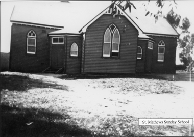 Stawell Historical Society Inc
Photograph, Presbyterian Sunday school building in Scallan Street c1930's
Presbyterian Sunday school building Scallan Street c 1930's.Two copies of a timber building with corrugated iron roof. The building is known as the Presbyterian Sunday School. St. Matthews Sunday Schoolstawell religion