Showing 1555 items matching "diamond creek"
-
 Eltham District Historical Society Inc
Document - Folder, Pearson, Lilian Maud and family
... Diamond Creek pub.... Lilian worked at Sutherland Homes and later at the Diamond Creek... at the Diamond Creek pub to help support the family. She enjoyed ...When Lilian Maud Pearson was 12 on 16 June 1933, her mother, Amelia (Millie), died; her sister Thelma had died a year earlier. Lilian worked at Sutherland Homes and later at the Diamond Creek pub to help support the family. She enjoyed the dances held by the Diamond Creek Fire Brigade and Panton Hill Cricket Club. Her best friend was Alice Grandy and her dance partners included Ken Stevenson, Jeff Brock (father of Peter Brock) who eventually opened Hurstbridge Garage service station, and Mick Rumney. Lilian married Mick who's real name was Charles Robert Rumney. Contents Paper, no date: "Lilian Maud Pearson" by Sue Rumney. Biography of Lilian Maud Pearson, mother-in-law of Sue Rumney.Newspaper clippings, A4 photocopies, etclilian maud pearson, lilian maud rumney (nee pearson), sue rumney, amelia pearson, millie pearson, thelma pearson, sutherland homes, joe pearson, nookie pearson, diamond creek pub, diamond creek fire brigade, panton hill cricket club, ken stevenson, jeff brock, peter brock, hurstbridge garage, alice grandy, mich rumney, charles robert rumney -
 Greensborough Historical Society
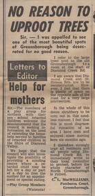
Newspaper Clipping - Digital Image, No reason to uproot trees, 21/08/1973
... diamond creek road... of trees near the corner of Diamond Creek Road and St Helena Road... about the removal of trees near the corner of Diamond Creek Road ...A Letter to the Editor complaining about the removal of trees near the corner of Diamond Creek Road and St Helena Road [1973] Digital copy of newspaper article, black text.diamond creek road, st helena road greensborough -
 Greensborough Historical Society
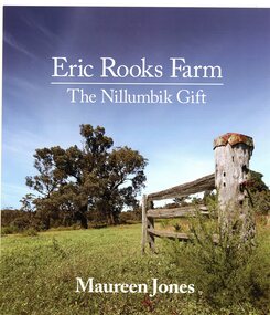
Book, Maureen Jones, Eric Rooks Farm: the Nillumbik gift; by Maureen Jones, 2022
... diamond creek...Eric Rooks bequeathed his family property in Diamond Creek... property in Diamond Creek to the National Trust as a gift ...Eric Rooks bequeathed his family property in Diamond Creek to the National Trust as a gift to the people of Nillumbik. The property is in Allendale Road.93p., illus,. (some col.)diamond creek, eric rooks, maureen jones, nillumbik -
 Eltham District Historical Society Inc
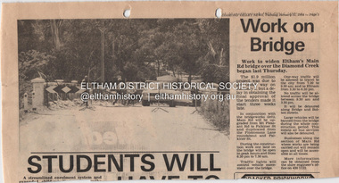
Document - Property Binder, Main Road Bridge, Eltham
... Diamond Creek...Newspaper article: Diamond Valley News, 31 January 1984... Creek. Main Road Bridges Main Road bridge Diamond Creek Eltham ...Newspaper article: Diamond Valley News, 31 January 1984, work to begin on widening of Main Road Bridge over Diamond Creek.main road, bridges, main road bridge, diamond creek, eltham (vic) -
 Greensborough Historical Society
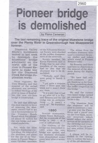
Newspaper clipping, Fiona Cameron, Pioneer bridge is demolished, by Fiona Cameron, 1974_
... diamond creek road... for the Diamond Creek Road bridge duplication.... in Greensborough, to make way for the Diamond Creek Road bridge duplication ...Describes the removal of the bluestone bridge abutment on the north side of the Plenty River in Greensborough, to make way for the Diamond Creek Road bridge duplication.Photocopy of news articleplenty river, diamond creek road -
 Greensborough Historical Society
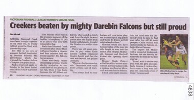
Newspaper Clipping, Diamond Valley Leader, Creekers beaten by mighty Darebin Falcons but still proud, 27/09/2017
... diamond creek football club...Had this Diamond Creek team been brought together in any... Plenty Lower Plenty melbourne Had this Diamond Creek team been ...Had this Diamond Creek team been brought together in any other era, its trophy cabinet would be flush with premiership cupsNews article 1 page, black text, colour image.vflw, diamond creek football club, darebin falcons football club, victorian football league women -
 Eltham District Historical Society Inc
Negative - Photograph, George W. Bell, Foot Bridge to Eltham High School, c.1960
... Diamond Creek (Creek)...Footbridge over the Diamond Creek at Dalton Street near... melbourne Footbridge over the Diamond Creek at Dalton Street near ...Footbridge over the Diamond Creek at Dalton Street near Withers Way. It has since been replaced and integrated into the Wingrove Park Trail.This photo forms part of a collection of photographs gathered by the Shire of Eltham for their centenary project book,"Pioneers and Painters: 100 years of the Shire of Eltham" by Alan Marshall (1971). The collection of over 500 images is held in partnership between Eltham District Historical Society and Yarra Plenty Regional Library (Eltham Library) and is now formally known as the 'The Shire of Eltham Pioneers Photograph Collection.' It is significant in being the first community sourced collection representing the places and people of the Shire's first one hundred years.Digital image 4 x 5 inch B&W Negsepp, shire of eltham pioneers photograph collection, eltham, eltham high school, foot bridge, bridge, dalton street, diamond creek (creek), george w. bell collection, wingrove park trail, withers way -
 Eltham District Historical Society Inc
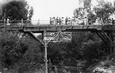
Negative - Photograph, Hurst's Bridge, c.1912
... diamond creek (creek)...-bridge after the timber bridge built over the Diamond Creek near...-bridge after the timber bridge built over the Diamond Creek near ...The area of Hurstbridge was originally known as Hurst’s-bridge after the timber bridge built over the Diamond Creek near Hurst’s station in late 1881/early 1882. A large group of people can be seen strolling across the timber bridge over the Diamond Creek on Hurstbridge-Arthurs Creek Road, Hurstbridge. It was built by John McDonald, of Arthur's Creek and was demolished and replaced in 1917 by a reinforced concrete arch bridge designed by John Monash.This photo forms part of a collection of photographs gathered by the Shire of Eltham for their centenary project book, "Pioneers and Painters: 100 years of the Shire of Eltham" by Alan Marshall (1971). The collection of over 500 images is held in partnership between Eltham District Historical Society and Yarra Plenty Regional Library (Eltham Library) and is now formally known as 'The Shire of Eltham Pioneers Photograph Collection.' It is significant in being the first community sourced collection representing the places and people of the Shire's first one hundred years.Digital image 4 x 5 inch B&W Negshire of eltham pioneers photograph collection, 1912, bridge, diamond creek (creek), hurstbridge, hurst's bridge -
 Greensborough Historical Society
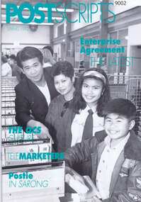
Magazine, Australia Post, Postscripts Spring 1992, 1992
... Diamond Creek Post Office... includes an article on Diamond Creek Post Ofice. ... includes an article on Diamond Creek Post Ofice. Diamond Creek Post ...The Australia Post Staff Journal contains work-related articles on postal services throughout Victoria. This edition includes an article on Diamond Creek Post Ofice. 32 p. magazine with black and green text and black and white photographs.diamond creek post office, postal services, australia post -
 Eltham District Historical Society Inc
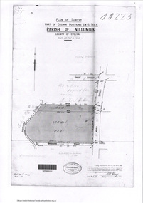
Document - Photocopy, Survey Fleld Notes of Part of Crown Portions 12 & 13, Section 4 at Eltham, Parish of Nillumbik, County of Evelyn, 6 May 1929
... Diamond Creek (Creek)...Portion of land bounded by: Main Road, York Street, Diamond..., Diamond Creek, Swan Street Application 48223 P.N. Guy, Licensed ...Portion of land bounded by: Main Road, York Street, Diamond Creek, Swan Street Application 48223 P.N. Guy, Licensed Surveyor, 6 May 1929application 48223, diamond creek (creek), eltham, main road, map, survey plan, swan street, york street -
 Greensborough Historical Society
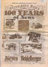
Newspaper, Heidelberg Leader, The Heidelberg News Special Edition. August 27 1997, 27/08/1997
... diamond creek... years of news in Heidelberg, Greensborough and Diamond Creek..., Greensborough and Diamond Creek. Includes articles outlining the history ...Special edition of the Heidelberg Leader commemorating 100 years of news in Heidelberg, Greensborough and Diamond Creek. Includes articles outlining the history of the area and includes historic photographs.40 pages, colour images and black text.heidelberg, greensborough, diamond creek -
 Greensborough Historical Society
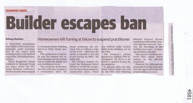
Newspaper Clipping, Diamond Valley Leader, Builder escapes ban, 24/05/2017
... diamond creek... to practice, infuriating home owners in Diamond Creek's Rangeview... in Diamond Creek's Rangeview Estate. diamond creek rangeview estate ...A Building practitioner who defied orders and is under investigation by the Victorian Building Authority is still allowed to practice, infuriating home owners in Diamond Creek's Rangeview Estate.News article 1 page, black text.diamond creek, rangeview estate -
 Greensborough Historical Society
Newspaper Clipping, Diamond Valley Leader, Reilly's pal a life-changer, 05/10/2016
... diamond creek...A Diamond Creek family whose son is autistic now have... Plenty Lower Plenty melbourne A Diamond Creek family whose son ...A Diamond Creek family whose son is autistic now have an assistance dog to support him, through the assistance of support group Dogs for Kids with Disabilities - Victoria.News clipping, black text and colour image.autism, diamond creek -
 National Wool Museum
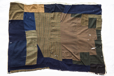
Quilt, 1880s
... diamond creek...), Diamond Creek and Costerfield in Victoria. His last residence... (near Beaufort), Diamond Creek and Costerfield in Victoria. His ...The wagga was owned by the great uncle of the donor's husband, George Stephens. Mr Stephens was a mining engineer in the late 1800s to early 1900s in Stawell, Main Lead (near Beaufort), Diamond Creek and Costerfield in Victoria. His last residence was at Bosterfield, where the wagga was used as a bed quilt in the mid 1940s. It may have also been used in the childhood home of Mr Stephens at Stawell. Mr Stephens saved the life of a blacksmith at Diamond Creek Gold Mine circa 1910.A wagga made from men's suits and coats, unpicked and sewn together. Pieces are in blue, brown checked and striped materials. There are remnants of a backing around the edges.wagga, running stitch collection, diamond creek, victoria, stawell, beaufort, costerfield -
 Eltham District Historical Society Inc
Photograph - Aerial Photograph, Intersection of Main Road and Bridge Street, c.1995
... Diamond Creek (Creek)... across to the Diamond Creek showing the Eltham Shire Offices... across to the Diamond Creek showing the Eltham Shire Offices ...View of Main Road from Henry Street to Brougham Street across to the Diamond Creek showing the Eltham Shire Offices (demolished 1996), the Eltham Library (opened 1994)aerial photo, alistair knox park, bridge street, brougham street, central park, diamond creek (creek), eltham, eltham community centre, eltham courthouse, eltham justice precinct, eltham living and learning, franklin street, henry street, local history centre, main road -
 Greensborough Historical Society
Photograph - Digital Image, View from Sondemeyers, 1925c
... diamond creek road... Hill' located near the corner of St Helena and Diamond Creek... Helena and Diamond Creek Roads. It looks south towards ...Photograph shows a view of Greensborough from 'Sondemeyers Hill' located near the corner of St Helena and Diamond Creek Roads. It looks south towards the township of Greensborough. It is a rural scene.Digital copy of black and white photograph.st helena road, diamond creek road, sondemeyers hill, greensborough -
Greensborough Historical Society
Oral History, Memories are rushing back. By Trinnie Di Giacomo, 1932o
... diamond creek road... on Diamond Creek Road in the early part of the 20th century. As told... on their farm on Diamond Creek Road in the early part of the 20th ...This oral history tells the story of Trinnie Di Giacomo (nee Whittingham) and her family's experiences on their farm on Diamond Creek Road in the early part of the 20th century. As told to Rosie Bray.A recollection of life in early Greensborough.3 pages, colour illustration.oral history, greensborough, diamond creek road, whittingham, trinnie di giacomo -
 Eltham District Historical Society Inc
Film - Video (VHS), Nillumbik Shire Council, The Nillumbik Story, 1996
... Diamond Creek... Society discusses the names Nillumbik and Diamond Creek... Society discusses the names Nillumbik and Diamond Creek ...PART 1 – NILLUMBIK (00:00-07:17) Opening features various scenes around Nillumbik Shire. For 40,000 years Nillumbik was the home of the Wurundjeri people. Robert Hoddle gave the district its name. Jock Ryan, then president of Nillumbik Historical Society discusses the names Nillumbik and Diamond Creek. In the late 1830s white occupation began with gold found in Warrandyte in 1851 and 12 years later at Diamond Creek -the Diamond Reef which led to the Caledonian gold rush. Jock Ryan discusses the Diamond Creek mine, which was thriving until it burnt out in 1915. Large numbers of workmen moved into area in late 1870s to construct the Maroondah Aqueduct. With growing population of Melbourne, the nearby Yan Yean system had severely disrupted the flow of the Plenty River, forcing the closure of three flour mills there. The aqueduct came to the rescue carrying water 66km from Healesville to Preston. When the Diamond Creek gold mine burnt down the local economy suffered but fruit growing industry had already been established and Diamond Creek became a thriving fruit growing centre. Interview with Jack Powell, a long-time fruiterer at St Andrews market, his family had lived in the area for a hundred years, 3 to 4 generations, “a lot of hard work”. By the time the railway arrived fruit growing was no longer competitive. The railway brought the city closer and day trippers. The Green Wedge separates the shire from the more densely developed neighbours such as Whittlesea, Doncaster, Templestowe, Bulleen and Greensborough. Population at the time (1996) was 19,000 but links to the past remain strong. Mudbrick houses along the Heritage Trail The saving of Shillinglaw Cottage from demolition in 1963 and relocation brick by brick. PART 2 – ENVIRONMENT (07:18-14:44) Peter Brock (with Bev Brock in background) at St Andrews market discusses his childhood growing up in the district and the environment and the values it instilled upon him and his own family. The Brocks have been in the district since the 1860s. Nillumbik Shire responsible for managing three catchment areas; Diamond Creek, Arthurs Creek and Watsons Creek. Follows the course of the Diamond Creek commencing in Kinglake through the district to its confluence with the Yarra River at Eltham at Eltham Lower Park. Highlights Eltham Lower Park community revegetation program and the newly constructed (1996) viewing platform built of new and recycled timbers at the confluence of the Diamond Creek and Yarra River. Also featured are outdoor recreation on the river and at Eltham Lower Park including the Diamond Valley miniature railway. Sugarloaf reservoir and recreational activities and fishing. Aerial view of Memorial Park and Shire of Eltham War Memorial tower at Garden Hill, Kangaroo Ground. Significant tourism opportunities for the shire with 3 million potential day-trippers in metropolitan Melbourne. Council and community working together to find a way to promote the shires natural and artistic assets. At Arthurs Creek, the Brock family and neighbours working together to take care of their waterway. Peter Brock’s uncle, Sandy Brock talks about environmental management and the Arthurs Creek Landcare group and actions to eradicate blackberry problem. Having previously planted Cypress rows they are replacing them with indigenous species to improve the water supply, keeping cattle out of the creek bed to improve the quality downstream flowing into the Yarra. Eltham East Primary School Band playing “All things bright and beautiful” merges into scenes of the bushland sanctuary set aside by the school in 1980 with unidentified teacher discusses the sanctuary and their education program and school children’s comments. Plight of a family of Wedgetail eagles nesting in the path of a developer’s bulldozer at North Warrandyte and actions to save their nesting areas. PART 3 – ARTS (14:45-22:00) Arts and Jazz festival at Montsalvat featuring interviews with Sigmund Jorgensen discussing Montsalvat and its principles. Also Matcham Skipper. Clifton Pugh’s funeral at Montsalvat and his legacy at Dunmoochin near Cottlesbridge with artists in residence, at the time, Chicago artist Charles Reddington who discusses the benefits of the experience. An unidentified female artist also talks about the program and why people are drawn to the area. Unidentified man on street talking about the amount of talent in the area, artists, poets, musicians, authors. Artist Ming Mackay (1918-2009) interviewed talking about the people she mixes with on “the Hill”. Works of local artists are displayed Eltham Library Community Gallery and Wiregrass gallery with a new coffee shop at the Wiregrass making it an even more popular destination. Music at St Andrews Hotel (may be a little bit country) and the Saturday market where likely to hear anything. Sellers and patrons at the market asked about what attracts them to the market and where they came from. Scenes of poets/authors giving readings. CREDITS Music by John Greenfield from the CD Sweet Rain “The Snow Tree”, Uncle Music UNC 2001 Cameras - David Mirabella and Peter Farragher Editor – Olwyn Jones Written and Produced by Jason Cameron A Jason Cameron Proction for Nillumbik ShireProvides a record of the relatively newly created Shire of Nillumbik at the time and the features and attactions of the shire in its people arts, culture and environmentVHS Cassette (five copies) DVD (one copy) Converted to MP4 file format 0:22:00, 1.60GBvideo recording, arthurs creek, arthurs creek landcare group, artists, artists in residence, arts, arts festival, authors, blackberry, brock family, bulldozer, bulleen, bushland sanctuary, caledonian gold rush, charles reddington, clifton pugh, cottlesbridge, cypress rows, developer, diamond creek, diamond creek mine, diamond reef, diamond valley miniature railway, doncaster, dunmoochin, education program, eeps, eltham, eltham east primary school, eltham east primary school band, eltham library community gallery, eltham lower park, environment, fishing, flour mill, fruit growing, fruiterer, garden hill, gold mining, green wedge, greensborough, heritage trail, hurstbridge railway line, jazz festival, jock ryan, kangaroo ground, kangaroo ground tower, kinglake, maroondah aqueduct, matcham skipper, memorial park, ming mackay (1918-2009), montsalvat, mudbrick houses, music, musicians, nesting area, nillumbik historical society, nillumbik shire, north warrandyte, old timer, orchards, peter brock, plenty river, poets, population, recreation, recreational activities, revegetation, robert hoddle, sandy brock, shillinglaw cottage, shire of eltham war memorial, sigmund jorgensen, st andrews hotel, st andrews market, sugarloaf reservoir, templestowe, the hill, tourism, viewing platform, warrandyte, water catchment area, watsons creek, wedgetail eagle, whittlesea, wiregrass gallery, wurundjeri, yarra river, jack powell -
 Eltham District Historical Society Inc
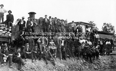
Photograph, First steam train to Hurstbridge
... Diamond Creek... of Diamond Creek area and people.)... railway line steam engine Diamond Creek Wattle Glen Railway Line ...A large group of men of varying ages stand on or beside the first steam train to Hurstbridge. Two hold children on their laps. A small group of seven boys also gather for the photo. The line opened on 2 January 1912 and was officially opened in June.The photo commemorates the culmination of many years of community and political agitation for the extension of the railway line. 100 years later the Hurstbridge railway line remains a vital part of Melbourne's public transport network. This photo forms part of a collection of photographs gathered by the Shire of Eltham for their centenary project book, "Pioneers and Painters: 100 years of the Shire of Eltham" by Alan Marshall (1971). The collection of over 500 images is held in partnership between Eltham District Historical Society and Yarra Plenty Regional Library (Eltham Library) and is now formally known as 'The Shire of Eltham Pioneers Photograph Collection.' It is significant in being the first community sourced collection representing the places and people of the Shire's first one hundred years.Digital image Also black and white copy of original mounted photo (broken) printed on glossy photographic paper 30.5 x 40.5 cm; image size approx. 18.5 x 28 cm (One of 36 photos (5 with duplicate prints) from Kevin Patterson of Nillumbik Historical Society, no captions, subjects largely unknown but mostly of Diamond Creek area and people.)sepp, shire of eltham pioneers photograph collection, hurstbridge, steam train, railroads, group, hurstbridge railway line, steam engine, diamond creek, wattle glen, railway line -
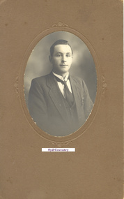 Greensborough Historical Society
Photograph - Digital Image, Young Syd Coventry, 1920c
... Diamond Creek ...A studio portrait of a young Syd Coventry. Digital copy of black and white studio portraitName has been added to photo.syd coventry -
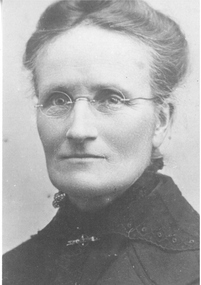 Greensborough Historical Society
Photograph - Digital image, Bruce McDowell, Jane Henrietta Coventry, 1863o
... Diamond Creek ...Photograph of Jane Henrietta Coventry nee Spencer 1863-1940 with details of her husband and 10 children. Jane and Henry Coventry's family included two champion AFL footballers, Syd and Gordon Coventry. Coventry Street [Montmorency] is named after her son Tom Coventry, who lived in the area.Photograph and notes, 2 p. black and whitecoventry family -
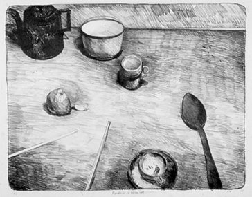 Nillumbik Shire Council
Print (lithograph) Peter WEGNER (b.1954 NZ - a.1958 AUS), Peter Wegner, Mandarin on Kitchen Table, 1983
... 93 Hillmartin Road, Diamond Creek, Outer Melbourne ...This work is by a local contemporary artist with a national and international reputation for figurative and portrait works. This lithograph comes from a series of still life by Wegner from the early 80's; a subject matter in which he has not returned to. Wegner is well known for his drawings and enjoys the immediate and directness of the process. He sees the drawn image as an experience of observation, with the content revealing the process of its making. Lithographic print - still life in black and white. Details several kitchen/household items: spoon, tea pot, egg holder, cup and saucer, bowl, chop sticks and mandarin.Lower far left: 'A/P'; Low centre: 'Mandarin on Kitchen Table'; Lower far right: 'PW 83'wegner, lithograph, still life, black and white, utensils, table, fruit, print -
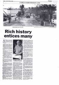 Greensborough Historical Society
Newspaper - Newspaper Clipping (copy), Valley Views, Rich history entices many, 1992_07
... diamond creek... society, how his interest in Diamond Creek history evolved.... jock ryan nillumbik historical society diamond creek Photocopy ...In this article, Nillumbik Historical Society President Jock Ryan (1992) discusses why people might join an historical society, how his interest in Diamond Creek history evolved and information on the history of the area. Photocopy of newspaper article, 1 page, black and white image.jock ryan, nillumbik historical society, diamond creek -
 Greensborough Historical Society
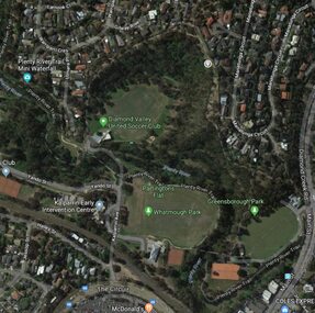
Aerial Photograph - Digital Image, Greensborough central with modern landmarks, 2015_
... diamond creek road greensborough... Trail. Bounded by Diamond Creek Road to the East and the Plenty... greensborough plenty river diamond creek road greensborough the circuit ...Aerial photograph of Greensborough showing modern landmarks and businesses, including Partington's Flat, Whatmough Park, Plenty River Trail. Bounded by Diamond Creek Road to the East and the Plenty River to the East, The Circuit to the South. Aerial photograph in colour with overlay text indicating modern landmarksgreensborough, manatunga circuit greensborough, plenty river, diamond creek road greensborough, the circuit greensborough, aerial photograph -
 Greensborough Historical Society
Photograph - Digital Image, Marilyn Smith, 3 St Helena Road Greensborough, 1920c
... diamond creek road greensborough... Greensborough (corner Diamond Creek Road). The house was built in 1920... of the house at 3 St Helena Road Greensborough (corner Diamond Creek ...Comparative photographs of the house at 3 St Helena Road Greensborough (corner Diamond Creek Road). The house was built in 1920. The first (black and white) photograph taken in the 1920s, the second (colour) photograph taken 2017.Digital copy of 2 photographs, one black and white, one colour.st helena road greensborough, diamond creek road greensborough -
 Greensborough Historical Society
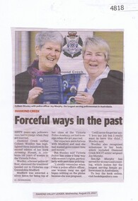
Newspaper Clipping, Diamond Valley Leader, Forceful ways in the past, 23/08/2017
... diamond creek police...Diamond Creek author Colleen Woolley has high-lighted... Plenty Lower Plenty melbourne Diamond Creek author Colleen ...Diamond Creek author Colleen Woolley has high-lighted injustices such as policewomen having to resign when they married, in the second edition of her book Arresting Women, to celebrate 100 years of women in the Victoria Police.News article 1 page, black text, colour image.colleen woolley, victoria police, arresting women, police, policewomen, joy murphy, diamond creek police -
 Eltham District Historical Society Inc
Photograph, Liz Pidgeon, Heritage Excursion; Maroondah Aqueduct, 3 September 2016, 3 September 2016
... diamond creek...Property related to Yarra Valley Water, Diamond Creek... melbourne Property related to Yarra Valley Water, Diamond Creek ...Property related to Yarra Valley Water, Diamond Creek Newsletter No., 229, August 2016 Heritage Excursion - Maroondah Aqueduct Walk - Saturday 3rd September The Maroondah Aqueduct was once a major link in Melbourne’s water supply system. It was built between 1886 and 1891 to transfer water from the Watts River near Healesville to the Preston Reservoir. It was 66 km in length, made up of 41 km of open channel, 10 km of tunnel through hills and 15 km of pipeline across stream valleys known as inverted siphons. The section of the aqueduct through the Eltham area has been abandoned since the 1980s but the open channel has largely been retained. A recreational path follows the aqueduct reserve. For our excursion on 3rd September we intend to walk along the section of the aqueduct adjacent to Allendale Road. This is a section not visited on previous excursions and includes the transition from open channel to the inverted siphon across the Diamond Creek valley. Apart from the aqueduct itself the main feature of the walk is the extensive views across Eltham North and Diamond Creek. Along the way we will talk about the history of the aqueduct and the area. This easy walk is about 3 km return and will take 2 to 2.5 hours. It will start at 2pm at the junction of Allendale Road with Godber Road and Zig Zag Road North, officially Diamond Creek, but on the northern boundary of Eltham. (Melway ref.12 B10). Born Digitalmaroondah aqueduct, eltham north, activities, eltham district historical society, heritage excursion, yarra valley water, diamond creek -
 Eltham District Historical Society Inc
Photograph, Liz Pidgeon, Heritage Excursion; Maroondah Aqueduct, 3 September 2016, 3 September 2016
... diamond creek...Sign for Yarra Valley Water at Diamond Creek property... melbourne Sign for Yarra Valley Water at Diamond Creek property ...Sign for Yarra Valley Water at Diamond Creek property Newsletter No., 229, August 2016 Heritage Excursion - Maroondah Aqueduct Walk - Saturday 3rd September The Maroondah Aqueduct was once a major link in Melbourne’s water supply system. It was built between 1886 and 1891 to transfer water from the Watts River near Healesville to the Preston Reservoir. It was 66 km in length, made up of 41 km of open channel, 10 km of tunnel through hills and 15 km of pipeline across stream valleys known as inverted siphons. The section of the aqueduct through the Eltham area has been abandoned since the 1980s but the open channel has largely been retained. A recreational path follows the aqueduct reserve. For our excursion on 3rd September we intend to walk along the section of the aqueduct adjacent to Allendale Road. This is a section not visited on previous excursions and includes the transition from open channel to the inverted siphon across the Diamond Creek valley. Apart from the aqueduct itself the main feature of the walk is the extensive views across Eltham North and Diamond Creek. Along the way we will talk about the history of the aqueduct and the area. This easy walk is about 3 km return and will take 2 to 2.5 hours. It will start at 2pm at the junction of Allendale Road with Godber Road and Zig Zag Road North, officially Diamond Creek, but on the northern boundary of Eltham. (Melway ref.12 B10). Born Digitalmaroondah aqueduct, eltham north, activities, eltham district historical society, heritage excursion, diamond creek, yarra valley water, sign -
 Eltham District Historical Society Inc
Photograph, Liz Pidgeon, Heritage Excursion; Maroondah Aqueduct, 3 September 2016, 3 September 2016
... diamond creek...View of Diamond Creek Newsletter No., 229, August 2016... melbourne View of Diamond Creek Newsletter No., 229, August 2016 ...View of Diamond Creek Newsletter No., 229, August 2016 Heritage Excursion - Maroondah Aqueduct Walk - Saturday 3rd September The Maroondah Aqueduct was once a major link in Melbourne’s water supply system. It was built between 1886 and 1891 to transfer water from the Watts River near Healesville to the Preston Reservoir. It was 66 km in length, made up of 41 km of open channel, 10 km of tunnel through hills and 15 km of pipeline across stream valleys known as inverted siphons. The section of the aqueduct through the Eltham area has been abandoned since the 1980s but the open channel has largely been retained. A recreational path follows the aqueduct reserve. For our excursion on 3rd September we intend to walk along the section of the aqueduct adjacent to Allendale Road. This is a section not visited on previous excursions and includes the transition from open channel to the inverted siphon across the Diamond Creek valley. Apart from the aqueduct itself the main feature of the walk is the extensive views across Eltham North and Diamond Creek. Along the way we will talk about the history of the aqueduct and the area. This easy walk is about 3 km return and will take 2 to 2.5 hours. It will start at 2pm at the junction of Allendale Road with Godber Road and Zig Zag Road North, officially Diamond Creek, but on the northern boundary of Eltham. (Melway ref.12 B10). Born Digitalmaroondah aqueduct, eltham north, activities, eltham district historical society, heritage excursion, diamond creek, acqueduct trail -
 Eltham District Historical Society Inc
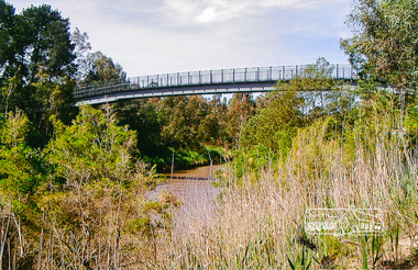
Photograph, Footbridge across the Yarra River at Eltham Lower Park
... diamond creek trail... and links the Diamond Creek Trail between the Shire of Nillumbik... and links the Diamond Creek Trail between the Shire of Nillumbik ...The Yarra River Footbridge was opened in August 2004 and links the Diamond Creek Trail between the Shire of Nillumbik and City of Manningham. It is a shared pathway and also links with the Main Yarra Trail. It affords lovely views over the Yarra River.Colour photographbridge, eltham lower park, eltham south, homestead road, lenister farm, yarra river, footbridge, lookout, diamond creek trail