Showing 1383 items matching "divided"
-
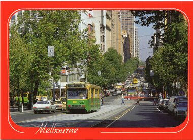
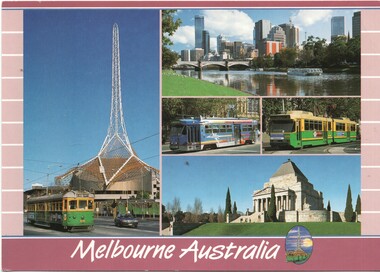 Melbourne Tram Museum
Postcard, Scancolor, Five Melbourne tram photos, early 2000's
Colour postcard divided back - Scancolor - titled Melbourne Australia, featuring five photographs on one card -1010 with the Arts Centre spire in the background, the view across the Yarra River, a Z3 advertising tram, B2 2013 and the Shrine of Remembrance. Back has space for name and address, stamp and a message and details of the postcard. Produced by Scan colour, possibly early 2000's.trams, tramways, postcards, w7 class, b class, z3 class, melbourne, yarra river, tram 1010, tram 2013 -
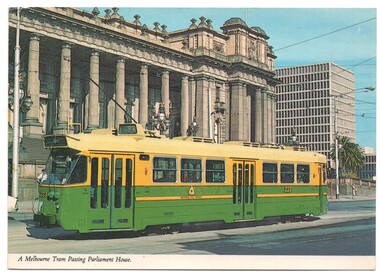 Melbourne Tram Museum
Postcard, Biscay Greetings, Z3 223 class tram outside Parliament, mid 1980's
Colour postcard divided back - Biscay Greetings, series of featuring Z3 223 class tram outside Parliament, in the Met colour scheme, on route 96. Back has space for name and address, stamp and a message and details of the postcard. Produced by Biscay Greetings, possibly mid 1980's. Card No. 2AUS 117. 2nd copy added 30/8/2020trams, tramways, postcards, spring st, route 96, z3 class, melbourne, tram 223 -
 Melbourne Tram Museum
Poster, Colonial Tramcar Restaurant Co, Colonial Tramcar Restaurant Tram No. 442, c1985
Poster - Full colour featuring Colonial Tramcar Restaurant Tram No. 442 with a background of Luna Park, Flinders St station and the Arts Centre with the words "Tramcar Restaurant - Tripping the Light Fantastic". On the rear is a divided back arrangement with space for stamp and an address, the company logo and name and contact details - no web site. c1985. See Reg Item 2173 for a postcard of this image.trams, tramways, restaurant tram, colonial tramcar restaurant, melbourne -
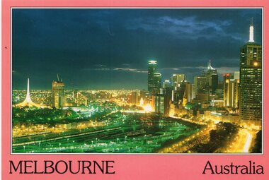 Melbourne Tram Museum
Postcard, Bartel Postcards, Melbourne from the Hilton Tower, early 1990's
Colour postcard red border, divided back - Bartel Postcards of a view of Melbourne from the Hilton Tower looking over the Flinders St rail yards at night. Back has space for name and address, stamp and a message and details of the postcard. Produced by Bartel Postcards possibly early 1990's Card No. BG006 Has "Melbourne Australia" along the bottom edge.trams, tramways, flinders st, melbourne, night photo, tram 2013 -
 Melbourne Tram Museum
Postcard, Biscay Greetings, Evening lights of Melbourne in Bourke St, mid 1980's
Colour postcard divided back, two photo panels - Biscay Greetings, 1. - Evening lights of Melbourne in Bourke St looking east from Queen. 2 - Z84 - Bourke St. Back has space for name and address, stamp and a message and details of the postcard. Produced by Biscay Greetings, possibly mid 1980's. Card No. BG255 two copies heldtrams, tramways, bourke st, z class, mall, tram 84 -
 Melbourne Tram Museum
Postcard, Biscay Greetings, A class 239 in Collins St at Swanston St, mid 1980's
Colour postcard divided back, with a red border, - Biscay Greetings, of A class 239 in Collins St at Swanston St. with the word "Melbourne along the lower edge. Tram is running a route 42 Back has space for name and address, stamp and a message and details of the postcard. Produced by Biscay Greetings, possibly mid 1980's. Card No. BG307 Two copies held.trams, tramways, a class, collins st, route 42, tram 239 -
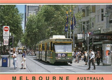 Melbourne Tram Museum
Postcard, Biscay Greetings, B class 2022 in Bourke St Mall, mid 1980's
Colour postcard divided back, with pink top and bottom borders, - Biscay Greetings, of B class 2022 in Bourke St Mall with the word "Melbourne along the lower edge. Tram is running a route 96, East Brunswick Back has space for name and address, stamp and a message and details of the postcard. Produced by Biscay Greetings, possibly mid 1980's. Card No. BG394trams, tramways, b class, bourke st, route 96, mall, tram 2022 -
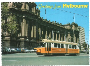 Melbourne Tram Museum
Postcard, Biscay Greetings, Z3 179 outside Parliament house, c1990
Postcard - serrated edges, with title "Greetings from Melbourne", featuring a photograph of Z3 179 outside Parliament house, c1990. Tram fitted with a trolley pole running a route 88. Produced by Biscay Greetings, postcard BG 148, with a map of Australia and the location of Melbourne marked. Divided back with space for stamp and address. 2nd copy added 30/8/2020trams, tramways, z3 class, parliament, route 88, spring st, tram 179 -
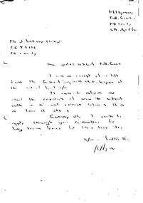 Falls Creek Historical Society
Document - Hand-Written - Re Sites 4 & 4a. (Almost Indecipherable)
Bob (Herman) Hymans (a former member of the Royal Netherlands Navy) was born in Bloemendaal, Holland on 30th September 1922. During World War II he fought against the Japanese in the Dutch East Indies (now Indonesia) and was imprisoned in Changi and on the Burma Railway. After gaining qualifications as a Ski Instructor, Bob arrived in Falls Creek in July 1950. Working as an Instructor and Supervisor at Bogong Lodge, Bob decided his future was in accommodation. He was successful in negotiating an indenture for land from the State Electricity Commission (SEC). It took Bob two years to build his Grand Coeur Chalet but, tragically, it was burned down in August 1961. Bob also built the first Chairlift in Australia. This was a single chairlift and the structure was built from wooden electricity poles. He was constantly full of new ideas and proposals for the village. Bob Hymans died on 7th July 2007. This Collection of documents and letters tells the story of Bob's endeavours to develop Falls Creek into the ski village it is today.This item is significant because it documents proposals put forward by Bob Hymans to develop facilities in the Falls Creek Tourist Area.A response from Mr. Hymans in response to the release of information related to the design of the extension to Christie Street in Falls Creek. As a result he wished to apply for a long-term lease of each site. I am in receipt of a letter from the General Superintendent Kiewa of the 3rd of April 1964. It was to inform me that the creation of new sites divided (?) with a 50’ ski road between them in trees of Site 4. Consequently, I wish to apply through your Committee for long term leases for the two sites. Yours faithfully H. Hymansfalls creek tourist area management committee, bob hymans, falls creek administration -
 Royal District Nursing Service (now known as Bolton Clarke)
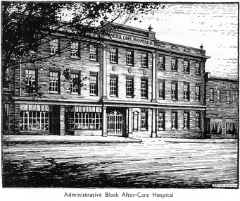
Photograph - Digital image, c.1934
The Melbourne District Nursing Society After-Care Home was extended and the name changed from 'Home' to 'Hospital' in 1934. This is a sketch of the Administrative building and shows the style of Hospital Architecture of the 1930sThe Melbourne District Nursing Society, (MDNS), built the After-Care Home in 1926. The Home was extended and the name changed to Melbourne District Nursing Society and After-Care Hospital in 1934. It was situated at 45 Victoria Parade, Collingwood. Patients of the Society who needed more care than could be given at home, but did not need hospitalization, were nursed there along with many patients from Melbourne hospitals who needed further care before going home. Many children were nursed in the hospital, some long term, during the Polio epidemic and schooling was given to them in the hospital. In September 1930 an Ante-Natal Clinic was established. In October 1934 a Women's Welfare Clinic was opened to educate women on birth control. This was the first of its kind in Melbourne. The After Care Hospital was under the Society's banner until 1956. In 1957 the MDNS and the After-Care separated with the Government taking over the running of the After-Care Hospital. Melbourne District Nursing Society then became the Melbourne District Nursing Service, later Royal District Nursing Service (RDNS) after Royal patronage in 1966..A digital image of a sketch of the front view of the After-Care Hospital. It shows a three storey building, and on the left of the ground floor are two large windows, each with a grid of approximately twenty-one small panes of glass; divided with sash bars holding the glass. To the right of this is a double scroll door, then the building divided with five, nine pane long windows along it. There is a column portico in front of the door. The second and third storeys have eleven rows of long small pane windows with the central brick section between the floors having three roundels attached. A flat roof section runs along the the top of the third storey with the words 'After Care Hospital' written in black capital letters in the centre. Above this central section is some balustrade with finials either end. To the right of this building; part of a two storey building with the same style windows can be seen. mdns, melbourne district nursing society, after- care hospital, after-care home, melbourne district nursing service -
 Warrnambool and District Historical Society Inc.
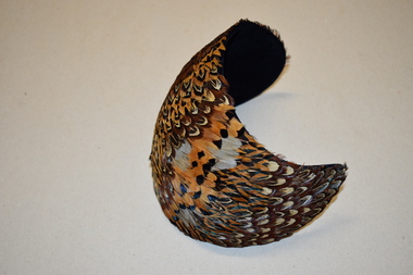
Feathered Hat, Custom Hats, c. 1940
This item comes from the great aunts of the donor, women of the Kinnear family of Allandale, Allansford. In the early 1840s William and John Allan took up large tracts of land to the east of the Hopkins River. In the late 19840s the run was divided, with William taking the Allandale section and John taking the Tooram section. In 1906 a portion of the Allandale section, including the homestead, was acquired by the Kinnear family. This hat is retained as an example of a woman’s hat from 80 years ago – stylish and eye-catching. It is also of interest as coming from the Kinnear family of Allansford.This is a woman’s hat – a spherical-shaped piece of dark blue felt or velvet curved to fit a head. The headpiece is covered with layers of small feathers in brown, yellow, black and white tonings. The label of the maker is on the inside of the hat. Urbi et Orbi Custom Hats Yokohamavintage hats, kinnear family, allansford, history of warrnambool -
 Stawell Historical Society Inc
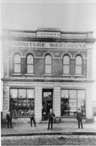
Photograph, T. Browns Furniture Warehouse at 113 Main Street Stawell
T. Browns Furniture Warehouse photo taken around c 1870's. Four people standing outside the front of the furniture warehouse. The two story building has two display windows divided into three panes. The entrance door is glass with five arch windows on the second story. The address is 113 Main Street Stawell, later the site of the Coles store.Photograph appears to be taken from an original sepia photo of T. Brown's Furniture Warehouse. The two story building has two display windows on the ground floor with four people standing on the footpath outside the building.T. Brown's Furniture Warehouse Ironmongers T. Brown's Timber Merchant stawell t. browns furniture warehouse business -
 Kew Historical Society Inc
Photograph - Flooding of the Yarra River in North Kew, 1934
North Kew, now divided between Kew and Kew East, bordered the Yarra River. As such, it was a region subject to flooding in the Yarra Valley. Development beyond this point (ie Kellett Grove) was limited by the City of Kew's planning regulations. Prior to urban development, the area since European settlement and the first land sales in the district in the 1840s, had been used for dairy farming. Small sepia snapshot taken from the river ramp of a house at 8 Kellett Grove, in what was then known as North Kew. The point of view is from a backyard looking towards Fairfield. Beyond the fence line are two almost submerged houses. A number of people are in a motor driven boat midstream. Fairfield at this period, (ie 1934) was noted for its limited river side development. Verso: 2/12/34 / TAKEN FROM OUR RAMPyarra river -- north kew, floods -- yarra valley, floods -- north kew, floods -- 1929, floods -- 1934, natural disasters -- kew -
 Kew Historical Society Inc
Photograph - 8 Kellett Grove, North Kew, 1929
North Kew, now divided between Kew and Kew East, bordered the Yarra River. As such, it was a region subject to flooding in the Yarra Valley. Development beyond this point (ie Kellett Grove) was limited by the City of Kew's planning regulations. Prior to urban development, the area since European settlement and the first land sales in the district in the 1840s, had been used for dairy farming. Small sepia snapshot taken of the front of 8 Kellett Grove, in what was then known as North Kew. Verso: 8 KELLETT GROVE / NORTH KEW / 1929 / 418 kellett gove -- north kew, californian bungalows, houses -- kellett grove -- kew (vic.) -
 Kew Historical Society Inc
Photograph - Flooding of the Yarra River in North Kew, 1934
North Kew, now divided between Kew and Kew East, bordered the Yarra River. As such, it was a region subject to flooding in the Yarra Valley. Development beyond this point (ie Kellett Grove) was limited by the City of Kew's planning regulations. Prior to urban development, the area since European settlement and the first land sales in the district in the 1840s, had been used for dairy farming. Small sepia snapshot taken from the back yard of a house at 8 Kellett Grove, in what was then known as North Kew. The point of view is from a backyard looking towards Fairfield. Floodwaters have submerged the fence and a clothes line. Verso: BACKYARD NTH. KEWyarra river -- north kew, floods -- yarra valley, floods -- north kew, floods -- 1934, natural disasters -- kew -
 Kew Historical Society Inc
Photograph - Flooding of the Yarra River in North Kew, 1934
North Kew, now divided between Kew and Kew East, bordered the Yarra River. As such, it was a region subject to flooding in the Yarra Valley. Development beyond this point (ie Kellett Grove) was limited by the City of Kew's planning regulations. Prior to urban development, the area since European settlement and the first land sales in the district in the 1840s, had been used for dairy farming. Small sepia snapshot taken from the back yard of a house at 8 Kellett Grove, in what was then known as North Kew. The point of view is from a backyard looking towards Fairfield. Verso: 8 KELLETT GROVEyarra river -- north kew, floods -- yarra valley, floods -- north kew, floods -- 1934, natural disasters -- kew -
 Kew Historical Society Inc
Photograph - Flooding of the Yarra River in North Kew, 1934
North Kew, now divided between Kew and Kew East, bordered the Yarra River. As such, it was a region subject to flooding in the Yarra Valley. Development beyond this point (ie Kellett Grove) was limited by the City of Kew's planning regulations. Prior to urban development, the area since European settlement and the first land sales in the district in the 1840s, had been used for dairy farming. Small sepia snapshot taken from the back yard of a house at 8 Kellett Grove, in what was then known as North Kew. The point of view is from a backyard looking towards Fairfield. Verso: OUR BACKYARD 8 KELLETT GROVEyarra river -- north kew, floods -- yarra valley, floods -- north kew, floods -- 1934, natural disasters -- kew -
 Kew Historical Society Inc
Photograph - View of the Yarra River from 8 Kellett Grove, North Kew, 1948
North Kew, now divided between Kew and Kew East, bordered the Yarra River. As such, it was a region subject to flooding in the Yarra Valley. Development beyond this point (ie Kellett Grove) was limited by the City of Kew's planning regulations. Prior to urban development, the area since European settlement and the first land sales in the district in the 1840s, had been used for dairy farming. The view from the rear of 8 Kellett Grove predates the construction of the Eastern Freeway so provides a rare view of the area before it was built.Small sepia snapshot taken from the back yard of a house at 8 Kellett Grove, in what was then known as North Kew. A tower of the Kew Asylum on the top left of the horizon assist the viewer to recognise that the land to the left of the river is in Kew and Studley Park.Verso: NORTH KEW 1948 / Stamped 51019yarra river -- north kew, kellett grove -- north kew -
 Kew Historical Society Inc
Photograph - Flooding of the Yarra River in North Kew, 1934
North Kew, now divided between Kew and Kew East, bordered the Yarra River. As such, it was a region subject to flooding in the Yarra Valley. Development beyond this point (ie Kellett Grove) was limited by the City of Kew's planning regulations. Prior to urban development, the area since European settlement and the first land sales in the district in the 1840s, had been used for dairy farming. Small sepia snapshot of floodwaters taken from near Kellett Grove, in what was then known as North Kew. The point of view is from a backyard looking towards Fairfield. In the foreground ar two men in a rowboat.Verso: OUR BACKYARD / Stamped 3 163yarra river -- north kew, floods -- yarra valley, floods -- north kew, floods -- 1934, natural disasters -- kew -
 Kew Historical Society Inc
Photograph - Flooding of the Yarra River in North Kew, 1934
North Kew, now divided between Kew and Kew East, bordered the Yarra River. As such, it was a region subject to flooding in the Yarra Valley. Development beyond this point (ie Kellett Grove) was limited by the City of Kew's planning regulations. Prior to urban development, the area since European settlement and the first land sales in the district in the 1840s, had been used for dairy farming. Small sepia snapshot of floodwaters taken from near Willsmere Road, in what was then known as North Kew. The point of view is looking towards Fairfield. In the foreground are two figures viewing a group in a rowboat in the middle of the flooded river. Semi-submerged street lighting indicates that entire streets had been. overwhelmed by the flood waters. Verso: WILLSMERE ROAD NORTH KEW / Stamped 3 163yarra river -- north kew, floods -- yarra valley, floods -- north kew, floods -- 1934, natural disasters -- kew, willsmere road -
 Kew Historical Society Inc
Photograph - Flooding of the Yarra River in North Kew, 1934
North Kew, now divided between Kew and Kew East, bordered the Yarra River. As such, it was a region subject to flooding in the Yarra Valley. Development beyond this point (ie Kellett Grove) was limited by the City of Kew's planning regulations. Prior to urban development, the area since European settlement and the first land sales in the district in the 1840s, had been used for dairy farming. Small sepia snapshot of floodwaters in North Kew. The point of view is of two houses belonging to local families that were surrounded by floodwater. Verso: HYATTS HOUSE / WILLSMERE ROAD / Stamped 3 163yarra river -- north kew, floods -- yarra valley, floods -- north kew, floods -- 1934, natural disasters -- kew, willsmere road -
 Kew Historical Society Inc
Photograph - Flooding of the Yarra River in North Kew, 1934
North Kew, now divided between Kew and Kew East, bordered the Yarra River. As such, it was a region subject to flooding in the Yarra Valley. Development beyond this point (ie Kellett Grove) was limited by the City of Kew's planning regulations. Prior to urban development, the area since European settlement and the first land sales in the district in the 1840s, had been used for dairy farming. Small sepia snapshot of floodwaters in North Kew, from the rear of 8 Kellett Grove. Verso: OUR BACKYARD / Stamped 52yarra river -- north kew, floods -- yarra valley, floods -- north kew, floods -- 1934, natural disasters -- kew, willsmere road -
 Kew Historical Society Inc
Photograph - Grandfather and granddaughter in the yard of 8 Kellett Grove, Kew, 1934
North Kew, now divided between Kew and Kew East, bordered the Yarra River. As such, it was a region subject to flooding in the Yarra Valley. Development beyond this point (ie Kellett Grove) was limited by the City of Kew's planning regulations. Prior to urban development, the area since European settlement and the first land sales in the district in the 1840s, had been used for dairy farming. Vivid photograph contrasting domestic life and relationships with natural disasters such as the flood of 1934.Small sepia snapshot of a grandfather and granddaughter sitting in the backyard of 8 Kellett Grove, North Kew, with the floodwaters stretching behind them.Verso: GRANDDAD AND I IN BACKYARDyarra river -- north kew, floods -- yarra valley, floods -- north kew, floods -- 1934, natural disasters -- kew, willsmere road -
 Kew Historical Society Inc
Photograph - Submerged houses in River Avenue, North Kew, 1934
North Kew, now divided between Kew and Kew East, bordered the Yarra River. As such, it was a region subject to flooding in the Yarra Valley. Development beyond this point (ie Kellett Grove) was limited by the City of Kew's planning regulations. Prior to urban development, the area since European settlement and the first land sales in the district in the 1840s, had been used for dairy farming. Vivid photograph contrasting domestic life and relationships with natural disasters such as the flood of 1934.Small sepia snapshot of two submerged houses belonging to local families in River Avenue, North Kew, during the 1934 floods. The view is presumably from near Kellett Grove looking north towards Fairfield.Verso: COES & HYATTS ROOF / RIVER AVENUE / Stamped: 6414yarra river -- north kew, floods -- yarra valley, floods -- north kew, floods -- 1934, natural disasters -- kew -
 Kew Historical Society Inc
Photograph - Flooding of the Yarra River in North Kew, 1934
North Kew, now divided between Kew and Kew East, bordered the Yarra River. As such, it was a region subject to flooding in the Yarra Valley. Development beyond this point (ie Kellett Grove) was limited by the City of Kew's planning regulations. Prior to urban development, the area since European settlement and the first land sales in the district in the 1840s, had been used for dairy farming. Vivid photograph contrasting domestic life and relationships with natural disasters such as the flood of 1934.Small sepia snapshot of the donors grandfather rescuing the family dog's kennel from rising floodwaters at the rear of 8 Kellett Grove, North Kew, .Verso: DAD SECURING NIPPY'S DOG KENNEL / Stamped 6414yarra river -- north kew, floods -- yarra valley, floods -- north kew, floods -- 1934, natural disasters -- kew -
 Kew Historical Society Inc
Photograph - Flooding of the Yarra River in North Kew, 1934
North Kew, now divided between Kew and Kew East, bordered the Yarra River. As such, it was a region subject to flooding in the Yarra Valley. Development beyond this point (ie Kellett Grove) was limited by the City of Kew's planning regulations. Prior to urban development, the area since European settlement and the first land sales in the district in the 1840s, had been used for dairy farming. .Small sepia snapshot of a local family's house in what was then River Avenue, North Kew being surrounded by floodwaters.Verso: THE SIDE OF RYANSyarra river -- north kew, floods -- yarra valley, floods -- north kew, floods -- 1934, natural disasters -- kew -
 Kew Historical Society Inc
Photograph - Flooding of the Yarra River in North Kew, 1934
North Kew, now divided between Kew and Kew East, bordered the Yarra River. As such, it was a region subject to flooding in the Yarra Valley. Development beyond this point (ie Kellett Grove) was limited by the City of Kew's planning regulations. Prior to urban development, the area since European settlement and the first land sales in the district in the 1840s, had been used for dairy farming. .Small sepia snapshot of what was then River Avenue, North Kew submerged by floodwaters.The photo was taken in the vicinity of 8 Kellett Grove, North Kew. Verso: TAKEN FROM OUR STREET JUST SEE A BIT OF RYAN'S FENCE / 1934yarra river -- north kew, floods -- yarra valley, floods -- north kew, floods -- 1934, natural disasters -- kew -
 Kew Historical Society Inc
Photograph - Flooding of the Yarra River in North Kew, 1934
North Kew, now divided between Kew and Kew East, bordered the Yarra River. As such, it was a region subject to flooding in the Yarra Valley. Development beyond this point (ie Kellett Grove) was limited by the City of Kew's planning regulations. Prior to urban development, the area since European settlement and the first land sales in the district in the 1840s, had been used for dairy farming. .Small sepia snapshot of the devastation caused by the 1934 flood.The photo was taken in the vicinity of Kellett Grove, North Kew and includes the roof of Chipperfield's Boathouse as well as other local houses.Verso: THIS IS CHIPPERFIELD'S BOAT SHEDS & COES & WILLIAMS TAKEN FROM OUR STREET / 1934yarra river -- north kew, floods -- yarra valley, floods -- north kew, floods -- 1934, natural disasters -- kew, chipperfields boathouse -
 Warrnambool and District Historical Society Inc.
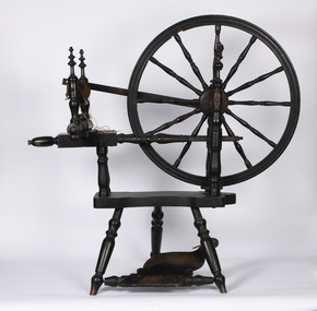
Functional object - Spinning Wheel, early 19th century
This spinning wheel was recovered in pieces from N.S.W. and re-assembled in the 1980s by Les O'Callaghan, a Warrnambool historian and President of the Warrnambool and District Historical Society for many years. The spinning wheel is believed to have belonged to Alice Allan (nee Mullaly) who married William Osborne Allan in 1844. They had three sons. William Allan was a pioneer settler who, in 1839/40, established, with his brothers, a property (Allandale) east of the Hopkins River in the area known today as Allansford. During the 1840s the property was divided with William taking up the Allandale section and his brother John taking the Tooram section. William died in 1860 and Alice continued to manage the property with the assistance of her sons until her death in 1887 when the Allandale estate was sub-divided. A spinning wheel such as this would have been an important item in a pioneer settler's home with the wife needing to spin wool or sometimes flax to produce cloth for clothing and furnishings. This spinning wheel is of considerable significance as it is believed to have belonged to Alice Allan, a pioneer settler in the Warrnambool district. This would make it one of the oldest and most interesting items in our collection.This is a spinning wheel made of metal and wood. The base stand has a foot pedal attached to the wheel and other sections of the spinning mechanism abovealice allan of allandale, william osborne allan of allandale, vintage household items, les o'callaghan warrnambool historian -
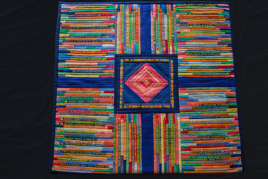 National Wool Museum
Quilt, Dressage Quilt, 1985
‘Dressage Quilt’ was made by Jan Ross-Manley for the Running Stitch exhibition Wool Quilts Old and New in 1985. The quilt is made from the sashes of winning female participates of Equestrian Sports in Victoria. The central diamond is divided into quarters, one for each woman who won the ribbons. The piece is about dedication, strength, exertion and achievement. The artist's statement reads: "I have been collecting pennants and sashes for some time now, intending to collate a series of pieces on Australian country life and people. This is a woman's quilt, made entirely from 'horse' sashes won at competition. The central diamond is divided into quarters, one for each lady who won the ribbons. 'Hurdles' are set into the inner borders. The piece is about dedication, strength, exertion and achievement. The all pervading yellow letters cast a tawdriness over the otherwise clean colour scheme." This quilt was later part of an identically titled exhibition held at the National Wool Museum in 1989.Large quilt consisting of numerous winning horse sashes sewn together to create a patchwork quilt separated into quarters, bordered by a royal blue trim. The centre of the quilt is a diamond shape made from various pink cotton strips and bordered by multi coloured horses heads. The quilt is backed with blue cotton and has a polyester fill.quilting history, patchwork history, running stitch group, running stitch collection, highlights of the national wool museum: from waggas to the wool quilt prize - exhibition (22/09/2001 - 02/12/2001), ross-manley, ms jan, quilting - history, patchwork - history