Showing 6427 items matching "housing"
-
 Eltham District Historical Society Inc
Photograph, Water Main Pipe Track (Madine Way-Bainbridge Drive), Eltham, 3 Sep 1981
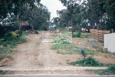
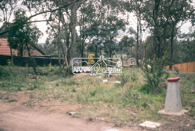
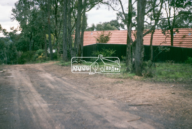
Roll of film taken by Eltham Shire Council officers of roads and houses in the Eltham East area, 3 September 1981 prior to construction of new water main; including views of existing damage to footpaths and gutters and general views of Beard Street. These images provide a perspective of housing estate developments and changes in housing styles and road development which began sweeping in from the mid 1970s with increasing urbanisation of what was once more outlying suburbs and regions.35mm colour positive transparency (1 of 28) Mount - Kodak Kodachrome Cardeltham, infrastructure, roads, bainbridge drive linear reserve, madine way, water main pipe track -
 Eltham District Historical Society Inc
Photograph, Water Main Pipe Track (Madine Way-Eucalyptus Road), Eltham, 3 Sep 1981
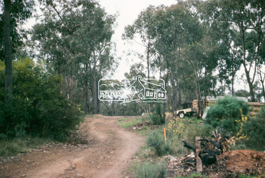
Roll of film taken by Eltham Shire Council officers of roads and houses in the Eltham East area, 3 September 1981 prior to construction of new water main; including views of existing damage to footpaths and gutters and general views of Beard Street. These images provide a perspective of housing estate developments and changes in housing styles and road development which began sweeping in from the mid 1970s with increasing urbanisation of what was once more outlying suburbs and regions.35mm colour positive transparency (1 of 28) Mount - Kodak Kodachrome Cardeltham, infrastructure, roads, water main pipe track, madine way, eucalyptus road, tadema park -
 Eltham District Historical Society Inc
Photograph, Water Main Pipe Track (Madine Way-Eucalyptus Road), Eltham, 3 Sep 1981
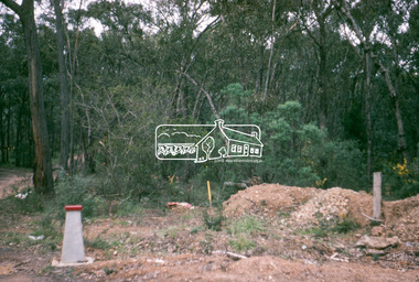
Roll of film taken by Eltham Shire Council officers of roads and houses in the Eltham East area, 3 September 1981 prior to construction of new water main; including views of existing damage to footpaths and gutters and general views of Beard Street. These images provide a perspective of housing estate developments and changes in housing styles and road development which began sweeping in from the mid 1970s with increasing urbanisation of what was once more outlying suburbs and regions.35mm colour positive transparency (1 of 28) Mount - Kodak Kodachrome Cardeltham, infrastructure, roads, water main pipe track, madine way, eucalyptus road, tadema park -
 Eltham District Historical Society Inc
Photograph, Water Main Pipe Track (Madine Way-Eucalyptus Road), Eltham, 3 Sep 1981
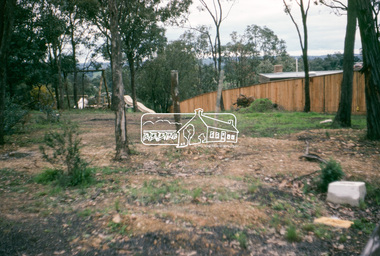
Roll of film taken by Eltham Shire Council officers of roads and houses in the Eltham East area, 3 September 1981 prior to construction of new water main; including views of existing damage to footpaths and gutters and general views of Beard Street. These images provide a perspective of housing estate developments and changes in housing styles and road development which began sweeping in from the mid 1970s with increasing urbanisation of what was once more outlying suburbs and regions.35mm colour positive transparency (1 of 28) Mount - Kodak Kodachrome Cardeltham, infrastructure, roads, water main pipe track, madine way, eucalyptus road, tadema park -
 Eltham District Historical Society Inc
Photograph, Water Main Pipe Track (Madine Way-Eucalyptus Road), Eltham, 3 Sep 1981
Roll of film taken by Eltham Shire Council officers of roads and houses in the Eltham East area, 3 September 1981 prior to construction of new water main; including views of existing damage to footpaths and gutters and general views of Beard Street. These images provide a perspective of housing estate developments and changes in housing styles and road development which began sweeping in from the mid 1970s with increasing urbanisation of what was once more outlying suburbs and regions.35mm colour positive transparency (1 of 28) Mount - Kodak Kodachrome Cardeltham, infrastructure, roads, water main pipe track, madine way, eucalyptus road, tadema park -
 Bendigo Historical Society Inc.
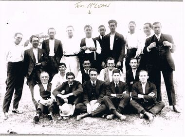
Photograph - PATRICIA COLES (NEE MCLEAN) COLLECTION: GOLDEN SQUARE RESIDENTS
Photograph. The Patricia Coles (nee McLean) collection. Golden Square Residents, possibly in 1930s. Copy of a black and white original photograph. Nineteen men posed informally in three rows. The man in the middle back row is identified as Tom McLean, Hotelier, United Kingdom Hotel Golden Square, father of Shirley, June and Patricia McLean.bendigo, housing, golden square residents, golden square. mclean, thomas. united kingdom hotel. -
 Whitehorse Historical Society Inc.
Document, A broad socio/economic profile of Nunawading 1981 - 1986, 1984
A report by the Strategic Planning Unit of City of Nunawading 1984A report by the Strategic Planning Unit of City of Nunawading 1984A report by the Strategic Planning Unit of City of Nunawading 1984city of nunawading, population, housing, transport, education -
 Ballarat Heritage Services
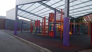
Photograph - Digital photograph, Lisa Gervasoni, Playground at Sacred Heart Catholic School, Kew, 2017
Colour photograph of a playground at Playground at Sacred Heart Catholic School, Kew kew, housing, streetscape, sacred heart kew, playground -
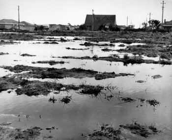 City of Kingston
Photograph - Black and white, c. 1958
Unsealed roads and drainage problems created difficulties for those living in Beaumaris during the 1950sBlack and white image depicting the Balcombe Road and Haywood Street, Beaumaris. Unsealed roads and drainage problems have created boggy slushy land. There are houses in the background, indicating people live in the area.Handwritten in red ink on reverse: 90% Handwritten in blue ink on reverse: 2193beaumaris, roads, drainage, water logged, housing -
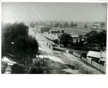 City of Kingston
Photograph - Black and white, Percy Fairlam, c. 1910
Black and white image of Cheltenham in the early 20th Century depicts an almost idyllic life. This photo was taken by Percy Fairlam, who climbed a tall pine tree to achieve the aerial view. The tree was a well recognised feature of the Cheltenham skyline but was cut down some time before World War II.Cheltenham was established as a rural market gardening community. The development of the railway was crucial to the ongoing development of the area. Community life sprung up around the railway line which is evident in the proximity of shopping and leisure.Black and white image depicting aerial view down Charman Road, Cheltenham, including the unsealed road, level crossing and shopping centre. What appears to be a cricket pitch is located behind the shops.Handwritten in black ink on a red round sticker adhered to the reverse, and then crossed out: X14 Handwritten in blue ink on reverse: A8 Handwritten in red ink on reverse: 85%cheltenham, railway crossing, roads, housing, shopping strip -
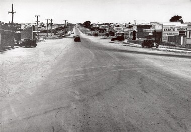 City of Kingston
Photograph - Black and white, 1950
This photograph depicts the increasing urbanisation of a once rural area at Moorabbin.This image is one of many in the collections that focuses on either roads or the railway. The development of roads and the railway was crucial to the ongoing development of the area. Black and white photograph of South Road, Moorabbin, with Station Street to the right and Jasper Road further down to the left. Along both sides of the road are retail spaces which become homes on the left hand side, after Jasper Road.Handwritten in red ink on reverse: 80% Handwritten in blue ink on reverse: 216moorabbin, roads, cars, shopping strip, housing -
Canterbury History Group
Article, Is Anybody Home, July 2024
Article on the trend to leave heritage homes empty and subject to vandalism and other trends changing the nature of historic Mangarra Road is featured as an example5 pages; coloured photosArticle on the trend to leave heritage homes empty and subject to vandalism and other trends changing the nature of historic Mangarra Road is featured as an example housing, town planning, urban development, social issues, mangarra road -
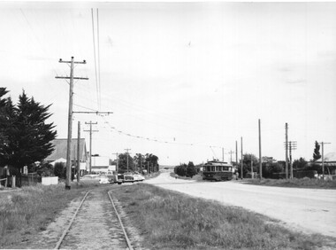 Ballarat Tramway Museum
Photograph - Black & White Photograph/s set of 2, Charles Craig, tram No. 27 travelling to Sebastopol in Albert St, early 1950's
Yields information about the traffic and appearance of Albert St Sebastopol during the 1950's and the buildings on either side of the street.Set of two black and white photographs of trams Photo possibly early 1950's of No. 27 travelling to Sebastopol in Albert St. .1 - crossing the roadway near Ophir St with the Trinity Church in the background. .2 - Tram at the Sebastopol Terminus with the new housing on the left side of the roadway and the Royal Mail Hotel. Both photos by Charles Craig trams, tramways, albert st, sebastopol, ophir st, tram 27 -
Maldon Vintage Machinery Museum Inc
Motorbike, Late 1940's
Restored for use in the movie "Romulus my Father".Two cylinder shaft drive motorbike with pillion seat on back mudguard. Restored for use in the movie "Romulus my Father". Spedometer in chromed headlight housing. Springing for front and back wheels, kick start. Black leather seat, black kneepads on petrol tank, bronze / gold petrol tank and mudguards, wire spoked wheels.On petrol tank, circular yellow enameled badge with a crown at top, central sun motif with rays and "Sunbeam" at bottom.transport ..... motor -
Tatura Irrigation & Wartime Camps Museum
Photographs - aerial, Hill Top Golf and Country Club, 1990's
Series of photographs of Hill Top Golf and Country Club from the air. Some show housing development on the surrounds. Taken prior to extensions to the north. Contained in L3868.38 aerial photographs of Hill Top Golf and Country Club.hill top development -
 Ballarat Heritage Services
Photograph - Photograph - Colour, St Paul's Bakery Hill, 2016, 03/12/2016
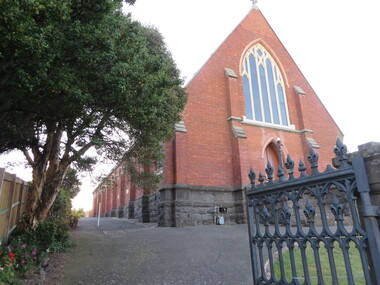
First housing parishioners in a tent on the Humffray Street site, the first wooden church was built March 1855, and was the first of three different churches to occupy the church yard. Colour Photograph of St Paul's Anglican Church, Bakery Hill, Ballarat. st paul's anglican church, bakery hill, bakery hill monster meeting, eureka stockade, eureka flag -
 Hume City Civic Collection
Photograph, early 1980s
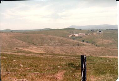
The Sunbury Tip was transferred from the end of Reservoir Road as housing development spread in that area to a site on the NW side of Mt. Holden near Riddell Road in the early 1980s.A landscape coloured photograph with rounded corners. It is a panoramic view of open country NW of Sunbury near Riddell Road. There is a fence post with barbed wire hanging from it in the immediate foreground and Macedon Ranges and part of the Western Highlands can be seen across the skyline.macedon ranges, mt. macedon, camel's hump, sunbury municipal tip, george evans collection -
Glen Eira Historical Society
Document - Capek, Irene Mrs
Typed notes by Irene Capek dated February 2001 describing her neighbor Rose, a long time resident of Norwood Road, and changes to the housing in Norwood Road, Caulfield North.capek irene, orrong road, dandenong road, caulfield, caulfield north, norwood road, suburban lifestyle, rose -
 Greensborough Historical Society
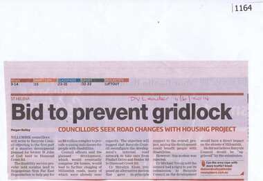
Newspaper clipping, Bid to prevent gridlock, 11/06/2014
Concerns are raised over possible traffic problems when the new housing estate is built on land previously owned by St John of God Accord in Diamond Creek Road Greensborough.News clipping, black and red text.DV Leader and date written on page.st john of god accord, town planning, traffic, greenhills -
 Robin Boyd Foundation
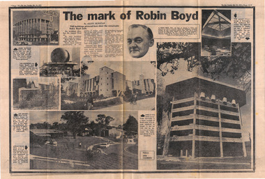
Newspaper - Clipping, Keith Dunstan, The mark of Robin Boyd, 19.10.1971
This is mostly a pictorial piece documenting many of Boyd's buildings - John Batman Motor Inn, The Fishbowl, Featherston house, Appletree Hill Housing Development, Menzies College, McCaughey Hall.A double page spreadwalsh st library -
 Robin Boyd Foundation
Newspaper - Clipping, Keith Dunstan, The mark of Robin Boyd, 19.10.1971
This is mostly a pictorial piece documenting many of Boyd's buildings - John Batman Motor Inn, The Fishbowl, Featherston house, Appletree Hill Housing Development, Menzies College, McCaughey Hall.A double page spread, pp 30-31. (3 copies)walsh st library -
 Hume City Civic Collection
Photograph
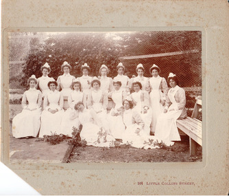
The nurses would have been employed at the Sunbury Asylum, which functioned for 120 years until in closed in 1992. The entire complex is now a housing estate, known as Jacksons Hill.Sunbury Asylum like other similar institutions were establish in outer rural areas or regional towns across the state. Mounted b/w photograph with corner of the mount cut off, of nurses. There is some damage from mould across the photograph and the cardboard mounting.264 Little Collins Streetnurses, occupations, sunbury hospital for the insane, george evans collection -
 Glenelg Shire Council Cultural Collection
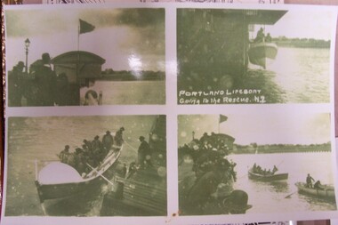
Photograph, Portland Lifeboat Going to the Rescue, n.d
Displayed at History House.Portland LifeboatSeries of 4 photos, sepia. 1. Shows building housing lifeboat - flag flying. Group of people. Gas light. 2. Lifeboat being lowered - crew on board. 3. Lifeboat in water - men wearing life jackets and using oars to push off. Man on pier. 4. Lifeboat and others rowing boat under way. Crowd on pier.Front: Portland Lifeboat. Going to the Rescueportland lifeboat, admella, portland, vessel -
 Orbost & District Historical Society
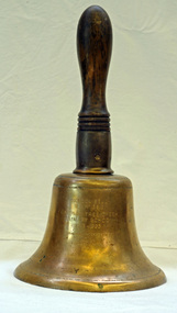
Functional object - Bell, hand-held, Early 20th century, c.1900s
The settlement of Cabbage Tree Creek is located on the Princes Highway, 27 km east of Orbost in East Gippsland. The creek, which flows through undulating forest, takes its name from the patches of Cabbage Fan palms growing along its course. A school commenced classes in 1913, but enrolment was small and at times the school operated part time with several other small schools in the area. The school building served as a hall for the district. About 1946 two sawmills commenced operations at Cabbage Tree Creek, and the Forests Commission ranger was stationed in the area. The increased population allowed the school to have more teachers and make improvements. In 1953, a new prefabricated building was erected on a new site. However, by the 1970s employment in the timber industry was unstable and the population decreased. By 1974 the school again had only one teacher and eventually closed in 1993 to amalgamate with the Orbost primary School in Ruskin Street, Orbost. (Ref. VictorianPlaces)The school bell is a signal that tells a school's students when it is time to go to class in the morning and when it is time to change classes during the day as well as when students are dismissed from school. In most schools today it will be a tone, siren, electronic bell sound, a series of chimes, or music played over an intercom but often still called "the school bell". This item reflects the history of Cabbage Tree Creek as well as the technological changes in the school system.Brass bell with incised double lines on bottom edge and top near handle, featuring descriptive notation on front face. Bell has long wooden handle shaped and incised with four lines at base before brass housing with singular screw holding handle in place. Object is showing signs of wear, with blackened handle and patches of green oxidisation.SCHOOL BELL / SS No 3812 / CABBAGE TREE CREEK / PRIMARY SCHOOL / 1913-1993 / FORMALLY INCORPORATED / INTO / ORBOST / PRIMARY SCHOOL / 1994cabbage tree, east gippsland, cabbage tree creek, cabbage tree creek primary school, orbost primary school, school bells -
 Port Melbourne Historical & Preservation Society
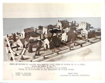
Photograph - Dunstan Estate during construction, Port Melbourne, Department of Public Works, 1936
Twenty five (25) black and white or sepia photographs of the houses of the Dunstan Estate during their building i.e. Griffin Crescent and Southwood Avenue .16 - .25 - photographs of models made by pupils of Architecture at the Department of Public Works . Shows eight types of houses to be erected. Chief Architect Percy E Everett and Henry Pye the Chairman of the Housing Committee built environment - domestic, domestic life, department of public works, dunstan estate, percy e everett, henry pye, albert dunstan -
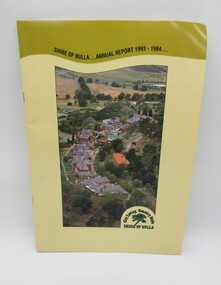 Hume City Civic Collection
Annual Report, Shire of Bulla: Annual Report, 1993 - 1994
The 1993 - 1994 Annual Report was published by the Shire of Bulla and distributed to the residents of the shire.A 24 paged publication with a yellow cardboard cover which has an aerial photograph which features the former Sunbury Asylum buildings and surroundings before the area was developed for housing. The former Shire of Bulla logo which featured 'City Living - Country Style' is in the bottom RH corner of the photograph. Details of the administration officxes of the Shire of Bulla are printed on the back cover.shire of bulla, annual reports, councillors, george evans collection -
Maldon Vintage Machinery Museum Inc
Steam Engine, C 1849
Thought to be the world's only working example of this engine. Used for driving overhead shafts in workshops, sawmills etc. Restored by members of the MVMM. Found at the Demsters property Shelbourne. Thought to be the only one of its kind in the world.Horizontal steam engine driving a flat belt pulley. Pulley shaft at right angles to engine shaft also carries a large flywheel. A mechanical oiler mounted on the engine base is activated by the engine valve shaft. Engine cylinder and valve housing painted dark green. Engine base, pulley and flywheel painted maroon. Oiler painted mid green.On engine valve box cover - Light green cast iron oval plate with "Cornelius Pettet / Engineer / Edinburgh" Brass plate on oiler - "Delvac Mechanical Lubricator / Design No 18376 / Made for and supplied by / Vacuum Oil Company Pty. Ltd. / Australia"machinery; engines; steam power source -
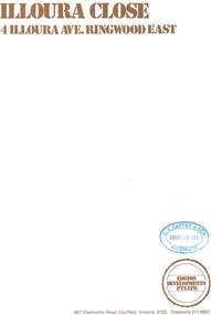 Ringwood and District Historical Society
Document - Sales Brochure, "Illoura Close" 4 Illoura Avenue, Ringwood East, Victoria. Circa 1970s
Folded brochure advertising sale of ten Group Housing Project properties, with list of features, site plan, location map, and typewritten summary of house sizes and prices. Edston Developments Pty. Ltd., 967 Glenhuntly Road Caulfield, Victoria, 3162. Telephone 211 6937. Architects: Clive Fredman and John Malina - 880 Toorak Road, East Hawthorn. Accompanying handwritten notation by Richard Carter R.E.S.I. - "Illoura Close (is) one of the few developments in Ringwood under the Cluster Titles Act".