Showing 831 items matching "land office"
-
 Ballarat Heritage Services
Photograph - Photograph - Colour, Clare Gervasoni, YMCA Ballalrat, 2016, 30/07/2016
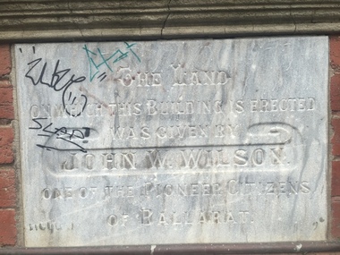
At one time pre-service teachers' of the Ballarat Teachers' College boarded at the YMCA. There also used to be an inside pool at the site. Three photographs relating to the YMCA Ballarat building, including the Foundation stone. The land on which this building is erected was given by John W. Wilson one of the pioneer citizens of Ballaratymca, young mens christian association, foundation stone, camp street, ballarat, john w. wilson -
 Ballarat Heritage Services
Photograph - Photograph - Colour, Former Lake Condah Aboriginal Mission, 17/04/2016
The Lake Condah Mission site includes bluestone ruins and a reconstructed timber building, as well as the cemetery which were part of the original settlement. With European settlement in the 1830s came conflict. Gunditjmara people fought for their land during the Eumerella wars, which lasted more than 20 years. As this conflict drew to an end in the 1860s, many Aboriginal people were displaced and the Victorian government began to develop reserves to house them. Many Aboriginal people refused to move from their ancestral land and eventually the government agreed to build a mission at Lake Condah, close to some of the eel traps and within sight of Budj Bim (Mt Eccles). The mission opened in 1867. The Mission was formally closed in 1918, and Aboriginal people were forced off the Mission, some moving to Lake Tyers. The Gunditjmara protested against the Mission’s closure and many continued to reside in the buildings until the majority of the reserve land was handed over to the Soldier Settlement Scheme in the 1940s. The mission was destroyed by the government in the 1950s in an effort to force the integration of Gunditjmara people with the general community but the Gunditjmara people continued to live in the area and protect their heritage. The mission lands were returned to the Gunditjmara in 1987. Lake Condah Mission is a place with special meaning to the Gunditjmara community - as a community meeting place, an administrative centre, a symbol of political struggle and a link to family histories. As a result the Gunditjmara community do not want open public access to this site. Key Features of Interest Ruins of stone cottages and plot remains of buildings such as the church Reconstructed dormitory building (https://www.budjbim.com.au/visit/cultural-sites/lake-condah-mission/?gclid=EAIaIQobChMIz6j36ZvF-QIV8ZhmAh2tmA3qEAAYASAAEgLxrvD_BwE, accessed 2022)Colour photographs of the former Lake Condah Aboriginal Missionlake condah, lake condah aboriginal mission, aborigines, aboriginal, gunditjmara, eumerella wars -
 Ballarat Heritage Services
Photograph - Colour, Clare Gervasoni, Seventh Street, Hepburn Springs, 2015, 25/08/2015
Colour photograph showing a block of land about to be built on at the Spring Creek side of Seventh Street in Hepburn Springs.hepburn springs -
Ballarat Heritage Services
Report, Box Ironbark Timber Resource Analysis Implications of proposed changes to land availability, 2000, 2000
A chapter on Box Ironbark Forests from the Wombat Community Forest Managemebt Resource Diskbox ironbark, forest, wombat community forest -
 Ballarat Heritage Services
Photograph - Photograph - Colour, Clare Gervasoni, St Francis Xavier Chapel, Eganstown, 1999, 28/09/1999
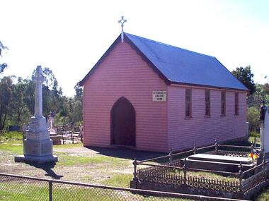
The St Francis Xavier Chapel and Catholic Cemetery was established on land donated vby squatter John Egan.Three photographs of St Francis Xavier Chapel, the chapel in the Eganstown Catholic Cemetery. The grave stone at the front of the church is for John Egan. st francis xavier chapel, eganstown, 1999, eganstown catholic cemetery, eganstown, church, chapel, cemetery, john egan -
 Ballarat Heritage Services
Photograph - Colour, Clare Gervasoni, Church Avenue, Hepburn Springs, from Bellinzona, 2004, 28/06/2004
The block of land depicted has been leveled with a huge rock barrier around the corner perimeter.Block of land on the corner of Borsa Crescent and Seventh Street.bellinzona, actea, hepburn springs, church avenue, seventh street, borsa crescent -
 Ballarat Heritage Services
Photograph - Colour, Clare Gervasoni, Borsa Crescent, Hepburn Springs, from Bellinzona, 2004, 28/06/2004
The block of land depicted has been leveled with a huge rock barrier around the corner perimeter.Block of land on the corner of Borsa Crescent and Seventh Street taken not long after Bellinzona and Wanda Inn had been burnt down.bellinzona, actea, hepburn springs, church avenue, seventh street, borsa crescent, wanda inn, fire -
 Ballarat Heritage Services
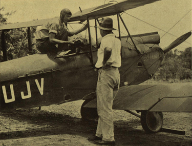
Image, Reverend Keith Langford-Smith and his Aeroplane, c1933, c1933
Two men and an aeroplanelangford-smith, aeroplane, missionary, arnham land, flight, sky pilot, pilot -
 Ballarat Heritage Services
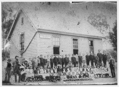
Photograph - Black and White, Yandoit Hill State School No. 691
... Office goldfields The land for this school was donated by Carlo ...The land for this school was donated by Carlo Gervasoni. When it closed it was moved to the corner of Main Road and Seventh Street, Hepburn Springs. Black and white photograph of three men standing either side of a number of school children of Yandoit Hill State School. yandoit, yandoit hills, yandoit creek, yandoit hill state school, gervasoni, hepburn springs -
 Ballarat Heritage Services
Photograph - Photograph - Colour, Clare Gervasoni, Hamburg Port, Germany, 2001, 27/08/2001
Many immigrants left for their new land from Hamburg, GermanyWaterside buildings at the Port at Hamburg, Germanyhamburg, germany, immigration, emigrations, port, german -
 Ballarat Heritage Services
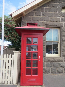
Photograph - Photograph - Colour, Clare Gervasoni, Koroit Post Office, 2015, 21/12/2015
The town borrows its name from the Koroitch Gundidj people who occupied the area prior to European settlement. (https://en.wikipedia.org/wiki/Koroit, accessed 21 December 2016) Koroit was first surveyed as a township in 1847. Around the 1850 the district had the highest population of Irish immigrants in rural Australia. The Koroit Post Office was designed by architect and engineer John Mason of Port Fairy. (Moyne Shire Heritage Study 2006 Stage 2, Volume 2: Environmental History, Prepared for Moyne Shire Council Helen Doyle in association with Context Pty Ltd, 2006.) Rosebrook Bridge, Rosebrook (1853; replaced) Post Office buildings, Bank Street, Port Fairy (c.1857) The author Henry Handel Richardson lived in the Koroit Post Office as a child after her family moved to Koroit in 1878. Remembering Koroit from her youth, the third volume in her The Fortunes of Richard Mahony trilogy is set in the town. When the author was six, her father Walter died in Koroit on 1 August 1879 and was buried at the Koroit cemetery. (https://en.wikipedia.org/wiki/Koroit, accessed 21 December 2016) In 1878 Mary Richardson was appointed postmistress of the Koroit Post Office at a salary of 72 pounds with free quarters, firewood and kerosene. She lived at the back of the Post Office. (From a Green and Pleasant Land by H. McCorkell and P. Yule.) Photographs showing the bluestone Koroit Post Office, phone box and postbox. It is located at 99 Commercial Road, Koroit. "Historic Area Statement of Significance: The significance of Koroit derives from its role as the urban centre of one of the most concentrated Irish Roman Catholic rural districts in Australia, noted for its mixed livestock and cropping argicultural patterns. This is reflected in two separate and distinctive areas in the town - the administrative/commercial area and the church precinct. The administrative and commercial area (focussing on the Boundary-Commercial Road/High Street intersection and the Koroit Hotel) consists of a number of significant public buildings and leads to a street of relatively intact humble shopfronts and kerbline verandahs, visually punctuated by opposing bank facades. The church precinct is dominated by a group of Catholic buildings larger in scale and more complete in range than those in any comparably sized Victorian town." http://vhd.heritagecouncil.vic.gov.au/places/69338#sthash.ELLuSMvg.dpuf, accessed 21 December 2016."koroit, post office, phone box, payphone, bluestone, henry handel richardson, koroit post office -
 Ballarat Heritage Services
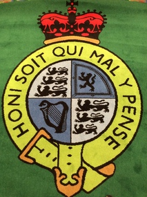
Digital Photograph, Supreme Court Emblem Carpet, Supreme Court, London, 2016, 09/2016
The supreme court emblem dominates the room. Designed by Yvonne Holton the Herald Painter at the Court of Lord Lyon in Scotland. Depicted are the symbols of each nation under the jurisdiction of the UK supreme Court. The Omega symbol around the edge symbolises the 'finality' of the decisions mad win the highest court in the land.Honi Soit Qui Mal Y Pensesupreme court emblem carpet, supreme court, london, logo, heraldic device -
 Ballarat Heritage Services
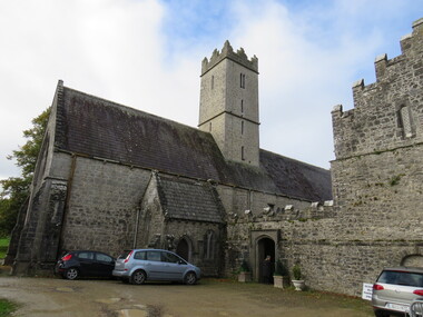
Photograph - Colour, St Nicholas' National School, Adare, Ireland, 2016, 09/2016
St Nichols' National School, Limerick, Ireland, is near the Adare Church, built on the grounds of good land beside a river where three groups of monks made their home during the Middle Ages. The Church was formerly the Black Friar's Abbey. The monastery was founded by John, Earl of Kildare, in 1315. The name of the old parish church was St Niholas where the school derived its name. On 2 June 1808 the local vestry meeting of the Church decided to abandon the old parish church of St Nicholas, the ruins of which are on the Estate, and the old Black Abbey was restores. The remains of the monasteries of all three orders of monks are in relatively good order still (considering their age) and two of them have been restores for worship. The first is the Trinitarian Abbey, otherwise known as the White Abbey, which is in the centre of the village of Adare. This was once the mother-house of a small influential order which had as its main object the ransoming and redeeming of Christian captives from the Moslems. The second is the ruin of the Franciscan Abbey in the demesne, beside the gold course. The third is the Augustinian Priory or the Black Friars' Abbey founded in 1315 by John, Earl of Kildare. Reference: Adare Church by The Right Reverend R. Wyse Jackson LITT.D., LL.D., D.D., Bishop of Limerick 1961-1970.st nicholas' national school, national school, education, schools, adare, ireland -
 Whitehorse Historical Society Inc.
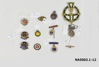
Medal - Badges, Approx 4. 1914 -1918 11. 1928-1929
1. Small circular white badge/red cross - bar pin 'A.N.C.M' 2. Oval medal with bar, long pin- red steward badge Royal Agricultural Show 3. Ditto - blue steward badge/brooch pin 4. AIF batch surmounted by crown 5. Oval Catholic religious medal/long chain 6. Oval badge: inscribed 7. Gold/Red/White/blue enamel badge - Free Trade 1929 8. Silver badge surmounted by crown/AP on red ground 9. Blue & gold badges: Eagle/shield/St John's Mitcham 10 & 11. Blue & gold badges: Eagle/shield/St John's Mitcham 11. Green & yellow circular on ring: Caufield Cricket Club 12. Ornate green/gold/white circular badge + pointed shaft1. Deo et Nomini Servimus A N C M 2. The Royal Agricultural Society of Victoria/Steward 3. The Royal Agricultural Society of Victoria/Steward 4. AIF - rest illegible/reverse: 4B349 5. Mostra TE ISS/Matrim/ Reverse: Congregation Des Enfants De Marie / scratched initials & date: B.Y.M 1891 6. P.J. Markham 678 Whitehorse Rd Mitcham Ringwood WNE 198 7.To promote land value, taxation and free trade. 4th International Conference Edinburgh 1929/Reverse: 50th anniversary of 'Progress & Poverty' by Henry George 8. Victoria ARP AH428 9&10. St John's Mitcham SJM Fide et Amorevinco/Reverse: scratched initials M.M. Millance 11. Caulfield Cricket Club1828-29 ccc/reverse: 20p.j. markham, mitcham post office -
 Ballarat Heritage Services
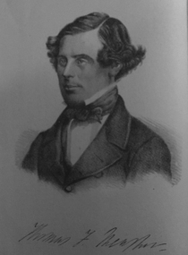
Photograph - Image, Thomas F. Meagher
Thomas Francis Meagher was an Irish nationalist and leader of the Young Irelanders in the Rebellion of 1848. After being convicted of sedition, he was first sentenced to death, but received transportation for life to Van Diemen's Land in Australia. (Wikipedia)Portrait of Thomas F. Meagher who was associated with the Young Ireland movement.young ireland, thomas f. meagher, convict, tasmania, van dieman's land -
 Ballarat Heritage Services
digital copy, Surveyor's Notebook Ballarat East, 24 August 1858
... Office goldfields Survey of land in Ballarat East in August 1858 ...Survey of land in Ballarat East in August 1858 showing hotels and tents etc. Images from Bellair's surveyor's book.eugene bellair, surveying, surveyor, eureka stockade -
 Ballarat Heritage Services
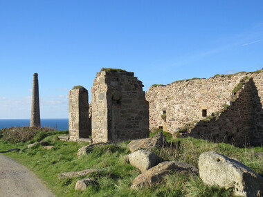
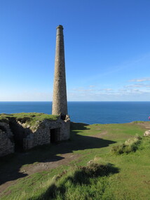
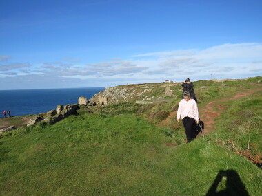
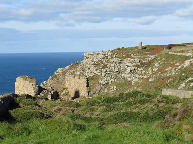
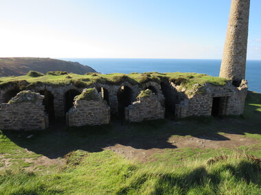
Photograph - Colour, Dorothy Wickham, St Just, Cronwall, World Heritage Site
A stone’s throw from Land’s End, this is the most westerly Area of the Site. St Just is characterised by big skies, jagged rocks, stark moorland, and iconic clifftop engine houses perched above the Atlantic in some incredible locations. No wonder this dramatic setting has inspired generations of artists, writers and photographers. World-famous for their mineralogy, the mining sites here are extremely well preserved – as is the sense of community amongst the people whose lives they once dominated. This Area’s unique geography and mineralogy meant that undersea mining was more concentrated here than anywhere else in the world in the 18th and 19th centuries. The oldest surviving Cornish beam engine (constructed in 1840) remains in its original engine house at Levant, restored and still working under steam. Geevor, one of the last mines to close in Cornwall (1990), was saved from demolition and is now the largest metalliferous mine site open to the public in the UK. The historic mining town of St Just is home to characteristic rows of granite mine workers’ cottages, public squares, shops, cafés, art galleries and, just off Bank Square, a medieval grassed amphitheatre – the Plen an Gwary or ‘playing place’.st just, world heritage, ellis, penrose, cornwall, mining, mines -
 Ballarat Heritage Services
Photograph - Colour, Dorothy Wickham, St Just, Cornwall, World Heritage Site
A stone’s throw from Land’s End, this is the most westerly Area of the Site. St Just is characterised by big skies, jagged rocks, stark moorland, and iconic clifftop engine houses perched above the Atlantic in some incredible locations. No wonder this dramatic setting has inspired generations of artists, writers and photographers. World-famous for their mineralogy, the mining sites here are extremely well preserved – as is the sense of community amongst the people whose lives they once dominated. This Area’s unique geography and mineralogy meant that undersea mining was more concentrated here than anywhere else in the world in the 18th and 19th centuries. The oldest surviving Cornish beam engine (constructed in 1840) remains in its original engine house at Levant, restored and still working under steam. Geevor, one of the last mines to close in Cornwall (1990), was saved from demolition and is now the largest metalliferous mine site open to the public in the UK. The historic mining town of St Just is home to characteristic rows of granite mine workers’ cottages, public squares, shops, cafés, art galleries and, just off Bank Square, a medieval grassed amphitheatre – the Plen an Gwary or ‘playing place’.st just, world heritage,, ellis,, penrose, cornwall, mining, mines -
 Ballarat Heritage Services
Photograph - Colour, Dorothy Wickham, St Just, Cornwall, World Heritage Site
A stone’s throw from Land’s End, this is the most westerly Area of the Site. St Just is characterised by big skies, jagged rocks, stark moorland, and iconic clifftop engine houses perched above the Atlantic in some incredible locations. No wonder this dramatic setting has inspired generations of artists, writers and photographers. World-famous for their mineralogy, the mining sites here are extremely well preserved – as is the sense of community amongst the people whose lives they once dominated. This Area’s unique geography and mineralogy meant that undersea mining was more concentrated here than anywhere else in the world in the 18th and 19th centuries. The oldest surviving Cornish beam engine (constructed in 1840) remains in its original engine house at Levant, restored and still working under steam. Geevor, one of the last mines to close in Cornwall (1990), was saved from demolition and is now the largest metalliferous mine site open to the public in the UK. The historic mining town of St Just is home to characteristic rows of granite mine workers’ cottages, public squares, shops, cafés, art galleries and, just off Bank Square, a medieval grassed amphitheatre – the Plen an Gwary or ‘playing place’.st just, world heritage, ellis, penrose, cornwall, mining, mines -
 Ballarat Heritage Services
Photograph - Colour, Dorothy Wickham, St Just, Cronwall, World Heritage Site
A stone’s throw from Land’s End, this is the most westerly Area of the Site. St Just is characterised by big skies, jagged rocks, stark moorland, and iconic clifftop engine houses perched above the Atlantic in some incredible locations. No wonder this dramatic setting has inspired generations of artists, writers and photographers. World-famous for their mineralogy, the mining sites here are extremely well preserved – as is the sense of community amongst the people whose lives they once dominated. This Area’s unique geography and mineralogy meant that undersea mining was more concentrated here than anywhere else in the world in the 18th and 19th centuries. The oldest surviving Cornish beam engine (constructed in 1840) remains in its original engine house at Levant, restored and still working under steam. Geevor, one of the last mines to close in Cornwall (1990), was saved from demolition and is now the largest metalliferous mine site open to the public in the UK. The historic mining town of St Just is home to characteristic rows of granite mine workers’ cottages, public squares, shops, cafés, art galleries and, just off Bank Square, a medieval grassed amphitheatre – the Plen an Gwary or ‘playing place’.st just, world heritage, ellis, penrose, cornwall, mining, mines -
 Ballarat Heritage Services
Photograph - Colour, Dorothy Wickham, St Just, Cornwall, World Heritage Site
A stone’s throw from Land’s End, this is the most westerly Area of the Site. St Just is characterised by big skies, jagged rocks, stark moorland, and iconic clifftop engine houses perched above the Atlantic in some incredible locations. No wonder this dramatic setting has inspired generations of artists, writers and photographers. World-famous for their mineralogy, the mining sites here are extremely well preserved – as is the sense of community amongst the people whose lives they once dominated. This Area’s unique geography and mineralogy meant that undersea mining was more concentrated here than anywhere else in the world in the 18th and 19th centuries. The oldest surviving Cornish beam engine (constructed in 1840) remains in its original engine house at Levant, restored and still working under steam. Geevor, one of the last mines to close in Cornwall (1990), was saved from demolition and is now the largest metalliferous mine site open to the public in the UK. The historic mining town of St Just is home to characteristic rows of granite mine workers’ cottages, public squares, shops, cafés, art galleries and, just off Bank Square, a medieval grassed amphitheatre – the Plen an Gwary or ‘playing place’.st just, world heritage, ellis, penrose, cornwall, mining, mines -
 Ballarat Heritage Services
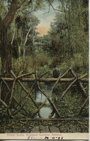
Postcard, Ballarat Botanical Gardens, c1908
"Within six years of its first land sales in 1852, founder members had challenged council over horticultural decisions and Ballarat's main thoroughfare contained fences squares, trees and flower beds. The major works that projected the Garden City image were the street plantings, parks and botanical gardens ..." Reference: Michael Taffe, Growing a garden City: Ballarat Horticultural Society 1859-2009, BHS Publishing, 2014, p. 10.This postcard shows how the botanical gardens in Ballarat, famous for being a Garden City.Coloured postcard Forest Scene, Botanical Gardens, Ballarat printed in red at bottom of card. Elaine 30-11-08 handwritten in black ink underneath.botanical gardens, ballarat, forest scene, gardens, botanical, -
 Ballarat and District Irish Association
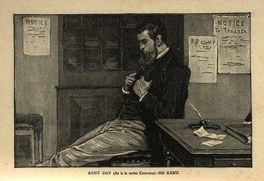
Image, Rent Day (as it is under coercion) - No Rent, c1864, c1864
Protection of Person and Property Act 1881 The ''Protection of Person and Property Act 1881'' was one of more than 100 Coercion Acts passed by the Parliament of United Kingdom of Great Britain and Ireland between 1801 and 1922, in an attempt to establish law and order in Ireland. The 1881 Act was passed by parliament and introduced by Gladstone. It allowed for persons to be imprisoned without trial. On 13 October 1881, the Act was used to arrest Charles Parnell after his newspaper, the ''United Ireland'', had attacked the Land Act. On Gladstone's return to office in 1880, William Edward Forster was made Chief Secretary for Ireland. He carried the Compensation for Disturbance Bill through the Commons, only to see it thrown out in the Lords. On 24 January 1881, he introduced a new Coercion Bill in the House of Commons, to deal with the growth of the Irish National Land League. Despite a 41-hour long fillibuster in the House by the Irish Parliamentary Party, the bill passed, among its provisions being one enabling the British government in Ireland to arrest without trial persons "reasonably suspected" of crime and conspiracy. However those arrested were often not always suspect, only supportive of the Irish National Land League's movements. Over 100 such acts were passed, some of the more notable of which were "An Act for the more effectual Suppression of Local Disturbances and Dangerous Associations in Ireland", "The Protection of Life and Property in Certain Parts of Ireland Act", and the "Protection of Person and Property Act 1881". An Irish Coercion Bill was proposed by Sir Robert Peel to calm the increasing difficult situation in Ireland as a result of the Great Famine 1844–47. The Bill was blocked and this led, in part, to Peel's retirement as Prime Minister. Later attempts to introduce Irish coercion acts were blocked by the filibustering of Joseph Biggar. As a response to the Plan of Campaign of the mid-1880s the new Chief Secretary for Ireland Arthur Balfour secured a tough Perpetual Crimes Act (1887) (or Coercion Act) aimed at the prevention of boycotting, intimidation, unlawful assembly and the organisation of conspiracies against the payment of agreed rents. The Act resulted in the imprisonment of hundreds of people including over twenty MPs. The so-called ''Crimes Act'' (or "Coercion" Act) was condemned by the Catholic hierarchy since it was to become a permanent part of the law and did not have to be renewed annually by parliament, but the Papacy issued the bull Link: "Saepe Nos" in 1888 which was uncritical of the Acts. Trial by jury was abolished. An influential analysis of the pros and cons of the Act was published in 1888 by W. H. Hurlbert, a Catholic Irish-American author. Many hundreds were imprisoned at times under the Acts, including many prominent politicians and agrarian agitators, Joseph Biggar, Alexander Blane, Michael Davitt, John Dillon, James Gilhooly, Patrick Guiney, Matthew Harris, John Hayden, J. E. Kenny, Andrew Kettle, Denis Kilbride, Pat O'Brien, William O'Brien, James O'Kelly, Charles Stewart Parnell, Douglas Pyne, Willie Redmond, Timothy Sullivan. [http://shelf3d.com/i/Irish%20Coercion%20Act, accessed 13/12/2013]A many sits on a table holding the lapels of his Jacket. ballarat irish, cabin, rent, tenants, quill, biggar, davitt -
 Ballarat and District Irish Association
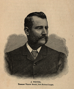
Image, Joseph Winter, c1864
Winter was Treasurer of the Irish National League. "AUSTRALIAN AID TO IRELAND. - GRATEFUL ACKNOWLEDGMENTS. The following letters have been received:— "The Irish National League, "43 O'Connell-street Upper, "Dublin, 14th Oct., 1886. "My Dear Mr. 'Winter, — I beg to acknowledge receipt of your favour of the 16th August, enclosing; draft for £250 from the Irish National League of Australasia towards the Irish Parliamentary Fund. The treasurers of the fund, to whom I have handed the draft, are transmitting by this mail a formal receipt for the amount of your generous contribution. ' I am very happy to learn from reports which have appeared in our newspapers here within the past few days that the vacancy in Melbourne has been accepted by our worthy, able, and patriotic prelate, the Most. Rev. Dr. Carr, Bishop of Galway. While the Catholic people of the diocese of Melbourne will find in Dr. Carr an able, zealous, and dignified prelate; of whom they will haye every rea son to be proud, the Irish Catholics of the diocese will, in an especial sense, find in him one who knows the wants of their country, who is deeply in sympathy with .the just feelings and aspirations of her people, and who is second to none in his desire to see his native land happy and prosperous I thought our friends in the Federal Council of the League would be anxious to know what man ner of man the new prelate is, and, therefore, writing to you so soon after his appointment I think it my duty to say so much. "Assuring our friends of our warm gratitude for the generous assistance they are continually giving us in the struggle in which we are en gaged — I remain, my dear Mr. Winter, yours sincerely, T. Harrington. "Joseph Winter, Esq., Advocate office, Melbourne," ''The Irish National League, 43 O'Connell-street Upper, " Dublin; 12th October, 1886. 'My Dear Sir, — I beg to acknowledge with thanks receipt of your letter of 16th August, with 'draft for' £250 from the Federal Council of the Irish National League of Australasia to the Parli mentary Fund. Joseph G. Biggar. ' 'J. Winter, Esq.' ' ; IRISH PARLIAMENTARY ELECTION FUND. The following acknowledgment has been received by the Rev. J. H. O'Connell, Victoria : — " The Irish National League, 45 O'Connell-street Upper, Dublin, 12th October, 1886. '"Rev. Dear Sir, — I beg to acknowledge with best thanks receipt of your letter of 24th August, with draft for £1000 towards the Irish Parliamentary Fund from the Executive Committee of the Irish Parliamentary Fund of Melbourne.— Yours faithfully, "Joseph G. Biggar. "Rev. J. H. O'Connell, St. George's Presbytery, Carlton, Melbourne." (Sydney Freeman's Journey, 4 December 1886) MR JOSEPH WINTER AND THE IRISH NATIONAL LEAGUE - Mr Joseph Winter, of Melbourne, has received a courteous letter from Mr. Harrington, M.P., enclosing the following official document : — ' On the motion of the Right Hon. the Lord Mayor, T. Sexton, M.P., seconded by Dr. B. J. Kenny, M.P., the following resolution was unani mously adopted by the Organizing Committee of the Irish National League :— 'That we have heard with regret of the proposed retirement from the treasurership of the Irish National League of Australia of Mr. Joseph Winter, manager of the Melbourne Advocate, and we seize this opportunity of placing on record our appreciation of tbe signal services which he has rendered to the Irish people by his unselfish and devoted advocacy of their cause, especially during the past eight years, during which time the sum of £27,487 has reached the home move ment through his hands. We desire to assure Mr. Winter that his services will not be forgotten by his countrymen in Ireland, and we venture to express the hope that the Irishmen of Australasia may still be permitted to command them.'(Sydney Freeman's Journal, 6 April 1889) Image of a moustached man known as Joseph Winter.ballarat irish, winter, bishop carr, carr, joseph winter, irish national league -
 Robin Boyd Foundation
Letter, Harold Lander to Robin Boyd and others. (Crawford Productions), 23.11.1967
Memo from Harold Lander, providing background information for a planning meeting to be held to discuss ‘Hunter’ television series. 'Hunter' is an Australian spy drama which ran from 4 July 1967 – 5 March 1969 on Nine Network. Lander writes about considerations for making the show commercially successful including publicity tactics. Robin Boyd is mentioned on page 9. Lander asks for his suggestion on a new set design for the Independent Surveys office for the show.Crawford Productions and Robin Boyd also explored ideas for other television productions, besides the successful 'The Flying Dogtor" series.Typewritten, carbon copy, foolscap, 11 pages.Black pen mark up on pages 1-9, red pen mark up on pages 1 and 2.hunter, australian television, crawford productions, homicide, nine network -
 Mt Dandenong & District Historical Society Inc.
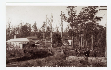
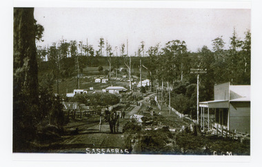
Photograph, Post Office Sassafras, c1930s
View of Hinkley Guest House on the left where the Post Office occupied a room in the front corner. The post operated from 1912 until 1937 when the building burned down. The Post Office then moved up to one of the Cadby Cottages near Rostrevor. The empty block of land next to Hinkley was where Sassafras School was built a few years later.Black and white copy of GGM photograph showing a group of five well dressed men in the foregroundbehind a large log with the Post Office and Telegraph office on the left.On front - POST OFFICE SASSAFRAS G.G.M.sassafras, post office, post office, hinkley, cadby cottages, sassafras school, rostrevor -
 Mt Dandenong & District Historical Society Inc.
Photograph, Sassafras, c1915
The south end of Sassafras Main Street outside the Big Store (Sherrards), built in 1912 that sold a bit of everything. The early settler Arthur Goode, who arrived in 1893, originally owned the land. Arthur Goode ran the Post Office in a bark hut until he moved away in 1911. From 1912 the Post Office operated from a room in Hinkley Guest House from 1912 until 1937.Black and white copy of a GGM photograph of Sassafras. A man driving a horse and cart is coming up the road towards the camera while several couples can be seen strolling down the road. The early buildings of Sassafras are clearly visible.sherrards, sassafras, arthur goode, goode, hinkley, post office -
 Mt Dandenong & District Historical Society Inc.
Photograph
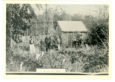
The Keoghs took up Lot 7 in the Village Settlement in 1905. John Keogh was a big Irishman and cleared many of the giant trees on his Lot 7. They had little water for their crops so grew gooseberries and red currants rather than the more valuable strawberries. Mrs Keogh (nee Cleary) inherited money in 1906 and they built a new weatherboard house. The original bush hut remained as the kitchen. Son James (Jimmie) married Mary Walsh, a teacher at the local school. Jimmie built the small shop on the triangle of land cut off when the CRB road went through. Jimmie and his wife left the district when he joined Victoria Police. Jimmie came back to the area and finally sold the land of Lot 7 to Rimington's Nurseries. He moved his family to Kilsyth. In 1939 the shop was moved across the road to be used as an office by the road builders. It burned down that year.Black and white photograph of a man, woman and young male standing outside a wooden hut. There are crop remnants in the foreground and a wooden paling fence behind the hut. A label on the front reads A SETTLER'S HUT. Reverse of photograph has handwritten description by John Lundy-Clarke.Front: A SETTLER'S HUT Reverse: 1905 Keogh's hut on Falls Road then Main Road. This was later the kitchen of their extended home as described in the narrative "Mountain of Struggle". The figures are - Mrs Keogh. John Keogh settler. Son James Keogh.keogh, john keogh, james keogh, jimmie keogh, mary walsh, cleary, shop, store, gooseberries, rimington's nursery -
 Mt Dandenong & District Historical Society Inc.
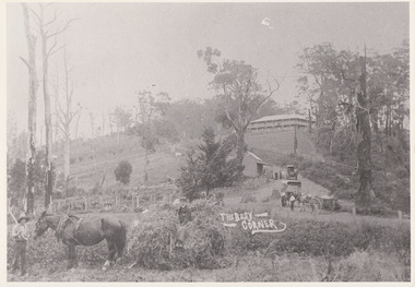
Photograph, The Busy Corner, 1907
View of Jeeves Saddle in 1907 showing everyday life and including important people and businesses from early settlement - Dodd's grocery and meat cutting carts; Beulah tea Rooms/Post Office; Mrs Hand, Fred Jeeves, Theo Hand.This photograph has a detailed inscription on the back handwritten by John Lundy-Clarke in 1974.“Jeeves Saddle” in 1907. Isaac Jeeves special strip of land Crown Allotment “C” 7 chains wide, lay between the sledge load of pea stalks and the far end of the verandah on Mrs Hand’s “Beulah Tea Rooms” which soon afterwards became the Mt Dandenong North Post Office. The coach road came up from the right behind the tall stump. The big woman in black was Mrs Hand. The wagon at the shop was Dodd’s grocery cart. The nearer wagon was the first coach on the mountain which had belonged to Briarty. The small cart was Dodd’s meat cutting cart. The elm trees are in the centre of the picture and above them is Price’s sign advertising their shop and newsagency. The big house is “Mountjoy” burnt 1975. Walker’s house is among the big trees left centre. Boy at horse’s head is Fred Jeeves. Boy on sledge is Theo Hand. The horse is “Blossom”. Barbers Road goes to the left from behind the elm trees.jeeves, theo hand, fred jeeves, isaac jeeves, barbers road, beulah tea rooms, post office, mount dandenong north, mt dandenong north, kalorama, coach, mountjoy