Showing 699 items matching "local councillors"
-
 City of Kingston
Photograph - Black and white, Moorabbin News, 1963
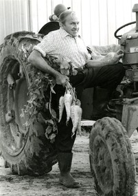
Francis (Frank) Wilbur Le Page was mayor of Moorabbin between 1980 - 1981, and again in 1984 - 1985. He was a lifelong resident of the region and also a third generation market gardener.In approximately 1854, Nicholas Le Page moved his family from Prahran to Cheltenham. Two years earlier, they had arrived in Melbourne from Guernsey Island. Nicholas Le Page was a tailor and his wife was a dressmaker. They decided to move into market gardening instead. Their son, Everest, married Lynda and Francis Wilbur Le Page was born in 1919. He attended Cheltenham State School where he completed his Merit Certificate in grade eight before studying bookkeeping, shorthand and typing at Bradshaw and Everett Business College in South Melbourne. Both Frank’s grandfather and father were active in local government. Francis Thomas Le Page was a councillor for 25 years and served a term as shire president in 1902. Everest, his son, was a councillor for the City of Moorabbin for 28 years and was mayor on two occasions. Frank also served two terms as mayor, first in 1980 and again in 1984. Frank died on 14 July 2008.Black and white photograph of Frank Le Page stepping down from a tractor, with a bunch of parsnips in his right hand.Pink coloured paper adhered to reverse with black printed text and handwritten text in blue ink: STANDARD NEWS / Paper MOOR / Catchline Garden / Percentage 88% / Date 17-10-84 / Page 23le page, market gardens, tractor, moorabbin -
 Bayside Gallery - Bayside City Council Art & Heritage Collection
Photograph - sepia photograph, Edwin G. Adamson, City of Sandringham Celebrations, 21st March 1923, 1923
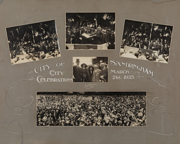
... on 9 April 1919 and a City on 21 March 1923. councillor ...On 21 March 1923, in the presence of 10,000 people, on the City Beach Oval, Sandringham was declared a City by the Earl of Stradbroke. Sandringham was originally part of the Shire of Moorabbin. On 28 February 1917, Sandringham was severed from Moorabbin and incorporated as the Borough of Sandringham. It was proclaimed a Town on 9 April 1919 and a City on 21 March 1923.councillor, sandringham, local government, municipality, mayor, city, proclamation, city of sandringham, lord stradbroke, lady stradbroke, mr. angelo bertotto, city beach oval, crowd, earl of stradbroke, governor, bayside, cr jpd beck, beach oval -
 Phillip Island and District Historical Society Inc.
Newspaper clippings
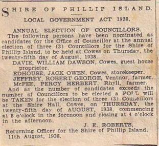
Newspaper ClippingAnnual Election of Councillors at Phillip Islandlocal history, documents, newspapers, council elections, phillip island, black & white newspaper clipping -
 Bayside Gallery - Bayside City Council Art & Heritage Collection
Sculpture - fountain, Margaret Baskerville, Mrs Bent Drinking Fountain, 1913
... of lower house local government councillor brighton public art ...The fountain was commissioned by Elizabeth Bleazby, daughter of Sir Thomas and Mrs Bent, and unveiled 27 October 1913 by Mrs Wilson, Mayoress of Brighton.The fountain is of historical interest and aesthetic significance. The memorial is a good example of the smaller commemorative work of sculptor Margaret Baskerville. The memorial commemorates the wife of notable local resident, Sir Thomas Bent, who was a long-standing parliamentary representative, Mayor of Brighton and Premier of Victoria from 1904-1909.bronze and granite thomas bent, politician, mayor, premier, bust, sculpture, margaret baskerville, speaker, member of parliament, member of lower house, local government, councillor, brighton, public art, bayside, mrs bent, memorial, fountain, drinking fountain, cherubs, elizabeth bleazby -
 Port Melbourne Historical & Preservation Society
Book - Town of Port Melbourne Valuation 1899, 1899
Valuation book, Town of Port Melbourne 1899. Dark grey with maroon spine and label gold-stamped. 71 spreads completed, listing name and occupation of tenant and owner of each property, description, number of rooms, size of property, rental etc. p72/3 removed, folded and placed in p73. (also Rates; assessments)"page 72-73 out for printers copy 29/9/00 ECC" on p73 Separate printers copy has order/instruction for next book in pencil, various markings on pages in pencil and in red ink (the latter indicating cross streets) Signed by Mayor, Town Clerk and an unidentifiable Councillorlocal government, built environment, joseph turner, edward c crockford, town clerks, henry norval edwards -
Port Melbourne Historical & Preservation Society
Book - Town of Port Melbourne Valuation 1897, 1897
Valuation book, Town of Port Melbourne 1897. Dark French blue cloth (?) cover stamped in gold with title. Tan suede spine and corners, red gold-stamped label on spine. Pages buff. Two page insert pasted into p. 70 being a handwritten letter from valuer detailling 128 houses removed, increase in population, extensions to buildings. (also Rates; assessments)Signed p. 70 by Mayor, Town Clerk and 2 councillors / p71: "Page 72 taken out for printers copy ECC 28/9/98" in purple pencil.local government, built environment, statistics, joseph turner, ad bacis, george samuel walter, n r tarrer, edward c crockford, town clerks -
Port Melbourne Historical & Preservation Society
Book - Town of Port Melbourne Valuation 1903-04, 1903
Valuation book, Town of Port Melbourne 1903-04. Dark blue green textured leather cover, tooled tan suede corners and spine, maroon labels gold-stamped. 76 spreads completed, listing name and occupation of tenant and owner of each property, description, number of rooms, size of property, rental etc. (also Rates; assessments)Errata added by valuer p 76 / signatures of Mayor, Town Clerk and Councillor Watson added in Feb 1904. Cross streets inserted in red ink.local government - town of port melbourne, built environment, joseph turner, william watson, arthur hester, edward c crockford, town clerks -
 Port Melbourne Historical & Preservation Society
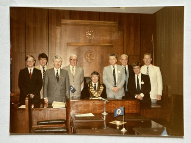
Photograph - Port Melbourne City Councillors c.1986, c.1986
Mayor, Perce WHITE with City of Port Melbourne Councillors c.1986. L - R; Phillip LANG; Barry MITCHELL; Nick TSILFOGLOU; Ray JULIER; Perce WHITE; Jim MITCHELL; Fred WINDUSS; Russell GRIFFITHS; Christopher RAEBURN.Colour photograph of Mayor & Councillors c.1986 in the Council Chamber at Port Melbourne Town Hall.local government - city of port melbourne, perce maguire-white, phillip lang, barry 'bomber' mitchell, nick tsilfoglou, ray julier, frederick robert winduss, russell griffiths, chris raeburn, james malcolm (jim) mitchell -
Port Melbourne Historical & Preservation Society
Audio - Perce WHITE, Glen COSHAM and Noel TURNBULL discuss their time as Port Melbourne Councillors, Glen Cosham, 17 Jun 2017
Perce WHITE, Glen COSHAM and Noel TURNBULL discuss their time as PMCC councillors during the 1970s. Recorded at Perce WHITE's place Duration 01:52:07local government - city of port melbourne, glen cosham, noel turnbull, perce mcguire white, perce white -
 Clunes Museum
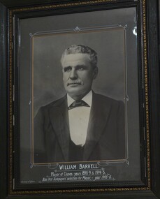
Photograph, 1898
... . PHOTOGRAPH HUNG IN CLUNES TOWN HALL DURING HIS TERM AS MAYOR. local ...IT IS ON PERMAMENT LOAN FROM HEPBURN SHIRE PHOTOGRAPH OF WILLIAM BARKELL. ELECTED BY RATEPAYERS AS MAYOR 1905 -6. PHOTOGRAPH HUNG IN CLUNES TOWN HALL DURING HIS TERM AS MAYOR.FRAMED PHOTOGRAPH OF CR. WILLIAM BARKELLMAYOR OF CLUNES YEARS 1898-98 &1904-5. ALSO FIRST RATEPAYERS SELECTION FOR MAYOR 1904-5. RICHARDS & CO PHOTOSlocal history, photography, photographs, councillors & officers -
 Clunes Museum
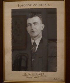
Photograph, HORNBY STUDIO - BALLARAT, C 1944
... TOWNHALL DURING HIS TERM AS MAYOR. local history photography ...IT IS ON PERMAMENT LOAN FROM HEPBURN SHIRE COUNCIL. CR. R.A. STEART WAS ELECTED TO CLUNES BOROUGH COUNCIL NOVEMBER 27TH. 1941, AND ELECTED MAYOR 1944-45. PHOTOGAPH ORIGINALLY HUNG IN CLUNES TOWNHALL DURING HIS TERM AS MAYOR.PHOTOGRAPH OF CR. R.A. STEART, FRAMEDBOROUGH OF CLUNES. R.A. STEART ELECTED COUNCILLOR NOV. 27TH. 1941 MAYOR 1944-45 HORNBY STUDIO BALLARATlocal history, photography, photographs, councillors & officers -
 Port Melbourne Historical & Preservation Society
Ceremonial object - Matchbox cover, City of Port Melbourne, 1939 - 1945
Appears to have been issued to soldiers, possibly embarking from Port Melbourne, in World War II. Item donated to PMHPS by David Graham, who received the item from a family member of the original recipient.Metal matchbox cover, with the City of Port Melbourne crest on one side and a message from the Mayor, Councillors and citizens of Port Melbourne on the other to departing soldiers during World War II"City of Port Melbourne - Victoria - Australia" "The Mayor, Councillors and citizenz of Port Melbourne extend to you all good wishes for a safe and speedy return - Cheerio!"armed services - army, armed services - navy, local government - city of port melbourne, war - world war ii -
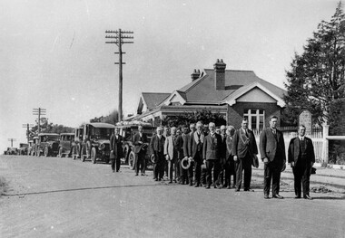 City of Kingston
Photograph - Black and white, Funeral procession of Francis Thomas Le Page, 1927
Funeral procession of Francis Thomas Le Page leaving Church of Christ, Chesterville Road, Cheltenham. Minister of church lead procession followed by members of the Star of Moorabbin Order of the Sons of Temperance Friendly Society wearing broad collars. F.T. Le Page was a councillor for 25 years and served as president of the Shire of Moorabbin in 1902/3. He died on 12 December 1927.Nicholas and Rachel (nee Addy) Le Page migrated from Geurnsey to Australia in 1852 with their young son Francis, who was less than a year old. They first lived in Prahran, setting up their own business and after about two years decided to move to Cheltenham and take up market gardening. The Le Page family has been associated with region ever since and have taken on many roles of prominence including local politics. Black and white image of a group of men, standing in two lines, all with hats off. They are standing in front of a line of cars. The first car in the line appears to have flowers on the roof which possibly indicates it is carrying the coffin in this funeral procession. -
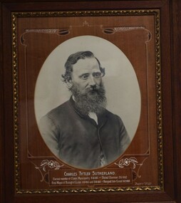 Clunes Museum
Photograph, RICHARDS & CO. PHOTOS, C. 1863
... . SUTHERLAND WAS ELECTED COUNCILLOR TO CLUNES BOROUGH COUNCIL IN 1861 ...IT IS ON PERMANENT LOAN FROM HEPBURN SHIRE COUNCIL. CR. C.T. SUTHERLAND WAS ELECTED COUNCILLOR TO CLUNES BOROUGH COUNCIL IN 1861, AND WAS MAYOR 1863 - 1867. THE PHOTOGRAPH ORIGINALLY HUNG IN THE CLUNES TOWN HALL DURING HIS TERM OF MAYOR.FRAMED PHOTOGRAPH OF CR. CHARLES TYTLER SUTHERLANDELECTED MEMBER OF CLUNES MUNICIPALITY 8.10.1861 ELECTED CHAIRMAN 25.2.1862. FIRST MAYOR OF BOROUGH OF CLUNES 1.10.1863 UNTIL 8.8.1867. RESIGNED FROM COUNCIL 14/2/1868 RICHARDS & CO PHOTOSlocal history, photography, photographs, councillors & officers -
Clunes Museum
Magazine - THE LOCAL
FORTNIGHTLY MAGAZINE "THE LOCAL" 10 MAY 2021 ARTICLE ON PAGE 27 ABOUT RICHARD FORD, COUNCILLOR, HORTICULTURALIST, ARTISTrichard ford, councillor richard ford -
 Eltham District Historical Society Inc
Photograph - Digital Photograph, Alan King, Reid family graves, Arthurs Creek Cemetery, 30 March 2008
The Arthurs Creek Cemetery was originally the private cemetery of pioneers Agnes and Patrick Reid. Published: Nillumbik Now and Then / Marguerite Marshall 2008; photographs Alan King with Marguerite Marshall.; p11 The Hazel Glen property, at Middle Hut Road, Arthurs Creek, which includes one of Victoria’s earliest pioneer buildings, was the forerunner to the Arthurs Creek and Doreen townships. At one time the Doreen Post Office and school were called Hazel Glen. The Hazel Glen State School No 945, before it was moved to its present site, stood on land to the south of Chapel Lane, which had been donated by Hazel Glen owner, William Reid. In May 1895 the post office was renamed Doreen to avoid confusion with the Reid’s address. The Arthurs Creek Cemetery was originally the private cemetery of Hazel Glen pioneers Agnes and Patrick Reid. The Reids with their eight children, arrived in Melbourne in April 1839. In 1844 Patrick Reid took over the licence to the Stewart Ponds run of 5120 acres (2072ha). Reid renamed it Hazel Glen, after Hazelden, the name of the Reid estate at Mearns in Renfrewshire, Scotland. Reid built a small cottage from local stone and hand-made bricks, with walls one yard (91 cm) thick, a flagstone floor and a shingle roof. Today two rooms and a store room survive as part of a larger house. Agnes died in 1847 aged 49, and was buried on a hill overlooking Hazel Glen, where it is said she had asked to be buried as it had been a favourite picnic spot.2 In 1858 Patrick died aged 74, and was buried near her. Their son William was to become Whittlesea Shire’s first president. From 1868 he was a Whittlesea Roads Board member, then a shire councillor until shortly before his death in 1923 aged 88. In 1865 the Reid’s burial area was no longer on their property, so it was declared a cemetery site. In 1867 it became the Linton Public Cemetery, being in the Linton Parish. However, to avoid confusion with Linton near Ballarat, the cemetery was renamed the Arthurs Creek Public Cemetery in 1926. Arthurs Creek was named after Henry Arthur, a pastoralist and public servant, who ran 1000 sheep lower down the Creek, from 1836 to 1841. It is believed he built his home at the end of today’s Challenger Street in Diamond Creek.This collection of almost 130 photos about places and people within the Shire of Nillumbik, an urban and rural municipality in Melbourne's north, contributes to an understanding of the history of the Shire. Published in 2008 immediately prior to the Black Saturday bushfires of February 7, 2009, it documents sites that were impacted, and in some cases destroyed by the fires. It includes photographs taken especially for the publication, creating a unique time capsule representing the Shire in the early 21st century. It remains the most recent comprehenesive publication devoted to the Shire's history connecting local residents to the past. agnes reid, arthurs creek cemetery, nillumbik now and then (marshall-king) collection, patrick reid, reid family -
 Greensborough Historical Society
Photograph - Photograph - Digital Image, Marilyn Smith, Greensborough Fallen Soldiers' Memorial 2019, 29/09/2019
Digital images of the Greensborough Fallen Soldiers' Memorial taken in 2019. The Memorial is shown from all four sides in its current position in relation to later memorials at Greensborough War Memorial Park. The Plaque was laid in 2015 and is inscribed "Greensborough War Memorial Park Time Capsule. Installed 11 November 2015 by Cr Craig Langdon, Mayor, and Cr Mark Di Pasquale, Bakewell Ward. Commemorating the Centenary of ANZAC. To be opened every 25 years." Names of 2015 Banyule Councillors are inscribed around edge of plaque.Part of a collection of miscellaneous historical images with a connection to the local area.Digital colour photographs fallen soldiers memorial greensborough, greensborough war memorial park, craig langdon, mark di pasquale, war memorials greensborough, plaques -
 Greensborough Historical Society
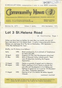
Newsletter, Greenhills and North Greensborough Progress Association, Community News: official journal of the Greenhills and Nth. Greensborough Progress Association. 29th September 1973. Edition No. 8/73, 29/09/1973
This edition includes a report on the Progress Association's September 1973 meeting, Councillor's report, Lot 3 St. Helena Road, In Memoriam [Frank Andrew], School and Kinder news, St. Helena Road... now and before, Forward planning and balanced development, Preservation of the local environment, Public reserves and how to protect them. A digital copy of this Newsletter is available from Greensborough Historical Society.Newsletter, 20 p., illus.greenhills and north greensborough progress association, greenhills -
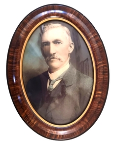 Wodonga & District Historical Society Inc
Photograph - Councillor Thomas Cunningham Reidy J.P
Thomas Cunningham Reidy was a native of Clare, Ireland. Shortly after arriving in Australia, he was employed as a travelling salesman for a brewery at Seymour, Victoria. In about 1872 with Mr Andrew McCormick, he carried on a business as storekeeper at various points along the North-Eastern Railway whilst the line was being constructed, finally arriving in Wodonga. Their partnership continued with the construction of the Carrier’s Arms Hotel and a general store which opened in 1874. The store drew trade from as far away as Wagga Wagga in New South Wales. The Carrier's Arms was also a coach stop for the Bethanga Express Coach. When the Wodonga Shire was created in 1876 after being severed from the Yackandandah Shire, Thomas Reidy was one of the first Councillors. He resigned in the following year, but was re-elected a year later. He served as Shire President in 1880–1881 and again in 1883–1884. He also served as a Justice of the Peace. In 1884 the partnership between Thomas Reidy and Andrew McCormick was terminated and the Carrier’s Arms was sold to Edmund T. Powell. Mr Reidy purchased the Tangambalanga Estate near Kiewa where he focussed on stock breeding, including horses. Whilst at Kiewa he was also one of the promoters of the local butter factory, and was the Chairman of the first Board of Directors of the Kiewa Butter Company. Early in 1896, Thomas Reidy sold Tangambalanga Estate to Mr L. R. Davies-Griffith, having already purchased the Club Hotel in Morwell. Unfortunately, he died in Morwell on 15th December 1896 leaving behind his wife Mary and 10 children including a new-born son.This portrait is significant because it depicts a citizen of Wodonga who played an important role in commerce and local government in Wodonga.A colourised photo of T.C. Reidy in an oval plastic frame.t.c. reidy, wodonga councillors, carriers' arms wodonga -
 Greensborough Historical Society
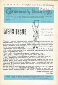
Newsletter, Greenhills and North Greensborough Progress Association, Community News: official journal of the Greenhills and Nth. Greensborough Progress Association and the Apollo Parkways Progress Association.1st September, 1976. Edition No. 8/76, 01/09//1976
This edition includes a report on the The Apollo Parkways Progress Association, Mens issue, 4 wheel driving, All a smokescreen?, Value of freedom or freedom of values, One view of our new shopping centre, Odds & sods, Local man has international voice [John O'Connor], What is a councillor's role?, From the Council Chambers, Meet the natives, Cameo of Len Delacca, Scout news, School and Kinder news, Fathering, Nursing Mothers Association, Parent Australia, This, that and the other, Diamond Valley Repertory, Malcolm Blair reserve. A digital copy of this Newsletter is available from Greensborough Historical Society. Newsletter, 32 p., illus.greenhills and north greensborough progress association, greenhills, apollo parkways progress association -
Clunes Museum
Administrative record - MINUTE BOOK, 22-8-1933 - 1949
ROYAL VICTORIAN INSTITUTE FOR THE BLIND AUXILIARY CLUNES WAS FORMED 9TH AUGUST 1933. PATRONESS. LADY PEACOCK PRESIDENT. MRS. FOULKES (MAYORESS) VICE-PRESIDENTS. MRS. OWENS, MRS. J.S.ANDERSON MRS. BARRY AND MRS TROUP. HON. SEC. MR. MILLSEN. HON. TREASURER. REV. T.S.ANDERSON ANNUAL MEMBERSHIP 1/- (TEN CENTS TO-DAY)BLACK COVERED BOOK CONTAINING THE MINUTES OF PUBLIC MEETING HELD IN CLUNES TOWN HALL AUGUST 9TH, 1933 FOR THE PURPOSE OF FORMING AN AUXILIARY FOR THE ROYAL VICTORIAN INSTITUTE FOR THE BLIND. MAYOR COUNCILLOR W.C.FOLKES PRESIDED AND TWENTY TWO LADIES AND GENTLEMEN WERE PRESENT.local history, books, documents, clunes blind auxiliary -
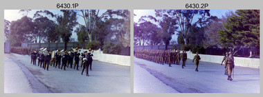
 Bendigo Military Museum
Photograph - Army Survey Regiment Freedom of Entry Parade, 1980
The Freedom of Entry to the City was an honour conferred by the Bendigo City Council to the Army Survey Regiment in 1970. 1980 was the third time the unit exercised its freedom of marching into the city with swords drawn, bayonets fixed and drums beating. The honour is usually bestowed upon local regiments, in recognition of their dedicated service, and it is common for military units to periodically exercise their freedom by arranging a parade through the city. Led by the Regiment’s CO – LTCOL Bob Skitch, the unit marched down View St in the CBD, along Pall Mall and up Gaol Rd to the Queen Elizabeth II Oval. The ceremonial parade followed with a march past the guests of honour, Mayor of Bendigo Councillor Paul Tomkinson and military dignitaries. The parade concluded after formal inspections of the troops. The Regiment also exercised its Freedom of Entry with anniversary parades in 1977, 1980, 1985, 1990 and 1995.These black and white photographs of the Army Survey Regiment were taken on the occasion of the Freedom of Entry parade to the City of Bendigo in 1980. The photographs were printed on photographic paper and are part of the Army Survey Regiment’s Collection. The photographs were scanned at 300 dpi. .1) Photo, black & white, L to R: MAJ Don Swiney, LTCOL Bob Skitch, WO1 Aub Harvey, unidentified, photographer in foreground – SGT Garran Hill .2) Photo, colour, black & white, L to R: MAJ Don Swiney, LTCOL Bob Skitch, WO1 Aub Harvey, unidentified .3) Photo, black & white, L to R: MAJ Don Swiney, WO1 Aub Harvey, LTCOL Bob Skitch, unidentified .4) Photo, black & white: 3rd MD Band .5) Photo, colour, L to R: MAJ Don Swiney, WO1 Aub Harvey, LTCOL Bob Skitch, unidentified .6) Photo, black & white, L to R: MAJ Don Swiney, WO1 Aub Harvey, unidentified, LTCOL Bob Skitch .7) Photo, black & white, L to R: SGT Stu Thaxter, LT Neil Taylor, CAPT Bob Roche .8) Photo, black & white, L to R: SPR Per Andersen – right marker .9) Photo, black & white, L to R: MAJ Peter Eddy .10) Photo, black & white, L to R: CPL Frank Lenane, CPL Flash Anderson, SGT Rhys De Laine, SPR Per Andersen .11) Photo, black & white, L to R: Mayor Paul Tomkinson .12) Photo, black & white, L to R: MAJ Don Swiney, WO1 Aub Harvey, unidentified, LTCOL Bob Skitch .13) Photo, black & white, L to R: unidentified personnel .14) Photo, black & white, L to R: unidentified personnel .15) Photo, black & white, L to R: unidentified personnel .16) Photo, black & white, L to R: unidentified personnel .18) Photo, black & white, L to R: CAPT Paddy Strunks, Mayor Paul Tomkinson, LTCOL Bob Skitch .19) Photo, black & white, L to R: Mayor Paul Tomkinson, CPL Bill Jones, CPL Gary Drummond, WO2 Tom Pattison .20) Photo, black & white, L to R: CAPT Paddy Strunks, WO1 Aub Harvey, Mayor Paul Tomkinson, SGT Rick Warren, CPL Andy Wilson …, WO2 Ted Burgess .21) Photo, black & white, L to R: LTCOL Bob Skitch, SPR Roy Hicks, Trevor Osborne, SPR Paul Baker, CAPT Stan Vote, CPL Bill Jones, Greg Francis-Wright .22) Photo, black & white, Air Survey Squadron inspection. Rear rank: SSGT Russell ‘Rusty’ Williams. Centre rank L to R: CPL Peter Treble, SGT Jim Beard, SPR Peter Hardy, SPR Steve Hilton, SPR John Lane, CPL Mick Hogan, Mayor – Councillor Paul Tomkinson. .23) Photo, black & white, L to R: Mayor Paul Tomkinson, CPL Marrianne (Van De Zee) De Groot, SPR Cathy Regan, SPR Ginny Turner, SPR Ilen Isaac, SPR Penny Knott, SPR Santina Argetto, SPR Gina Coore .24) Photo, black & white, L to R: Mayor Paul Tomkinson, SPR Cathy Regan, SPR Ginny Turner, SPR Ilen Isaac, SPR Penny Knott, SPR Santina Argetto, SPR Gina Coore, WO2 Pat Lumsden .25) Photo, black & white, L to R: LTCOL Bob Skitch, Mayor Paul Tomkinson, SPR Ilen Isaac, SPR Penny Knott, SPR Santina Argetto, SPR Gina Coore, WO2 Pat Lumsdenroyal australian survey corps, rasvy, fortuna, army survey regiment, army svy regt, asr -
 Bendigo Military Museum
Photograph - Army Headquarters (AHQ) Survey Regiment Freedom of Entry Parade, Bendigo CBD, 1970
The Freedom of Entry to the City was an honour conferred by the Bendigo City Council to the AHQ Survey Regiment on the 20th of April 1970. The unit was granted for the first time the privilege of marching into the city with swords drawn, bayonets fixed and drums beating. The honour is usually bestowed upon local regiments, in recognition of their dedicated service, and it is common for military units to periodically exercise their freedom by arranging a parade through the city. The Freedom of Entry Parade occurred on the 14th of June 1970 led by the Regiment’s CO – LTCOL Bill Sprenger MID, MBE; the unit marched up View St in the CBD to the Queen Elizabeth II Oval. The ceremonial parade followed with a march past the guests of honour, Mayor of Bendigo Councillor Clark Jeffrey and military dignitaries. The parade concluded after formal inspections of the troops. A ceremonial scroll was presented to the Bendigo City Council to the AHQ Survey Regiment citing the occasion and was proudly displayed in the entry foyer to Fortuna Villa up to October 2008. The Regiment continued to exercise its Freedom of Entry with anniversary parades in 1977, 1980, 1985, 1990 and 1995. Refer to item 6020.8P for another set of photos of this event scanned from photographic prints.This set of 39 colour photographs were taken on the occasion of the Army Headquarters (AHQ) Survey Regiment’s Freedom of Entry parade to the City of Bendigo on the 14th of June 1970. The photographs are on 35mm negative film. They are part of the Army Survey Regiment’s Collection. The photographic negatives were scanned at 96 dpi. .1) to .2) - Photo, colour, 1970. AHQ Survey Regiment marches to Queen Elizabeth Oval entry, led by CO LTCOL Lionel Sprenger MBE, MID, unidentified 2IC and RSM WO1 John Hogan. .3) to .4) - Photo, colour, 1970. AHQ Survey Regiment at entry to Queen Elizabeth Oval, exercising its right of entry to City of Bendigo. .5) to .6) - Photo, colour, 1970. AHQ Survey Regiment marches down View St in the City of Bendigo. .7) to .11) - Photo, colour, 1970. AHQ Survey Regiment marches up View St in the City of Bendigo. .12) to .13) - Photo, colour, 1970. AHQ Survey Regiment enters Queen Elizabeth Oval, led by CO LTCOL Lionel Sprenger MBE, MID, unidentified 2IC and RSM WO1 John Hogan. .14) - Photo, colour, 1970. One of AHQ Survey Regiment’s squadrons enters Queen Elizabeth Oval. .15) to .19) - Photo, colour, 1970. AHQ Survey Regiment forms up on Queen Elizabeth Oval awaiting arrival of dignitaries. .20) - Photo, colour, 1970. AHQ Survey Regiment inspected by dignitaries. L to R: Director of the Survey Corps COL Frank Buckland OBE, MID; Colonel Commandant BRIG Don Macdonald AM, MID; unidentified General, CO LTCOL Lionel Sprenger MBE, MID, Mayor of Bendigo Councillor Clark Jeffrey, unidentified personnel. .21) to .23) - Photo, colour, 1970. AHQ Survey Regiment inspected by dignitaries. Director of the Survey Corps COL Frank Buckland OBE, MID; Colonel Commandant BRIG Don Macdonald AM, MID; unidentified General, CO LTCOL Lionel Sprenger MBE, MID, Mayor of Bendigo Councillor Clark Jeffrey. WRAAC personnel centre rank - PTE Desi Asaris, rear rank L to R: unidentified, PTE Pat Lumsden, PTE Heather (Turnbull) Slater, SGT Irene (Rankins) Saunders. .24) to .27) - Photo, colour, 1970. Band inspected by dignitaries. Director of the Survey Corps COL Frank Buckland OBE, MID; Colonel Commandant BRIG Don Macdonald AM, MID; unidentified General, CO LTCOL Lionel Sprenger MBE, MID, Mayor of Bendigo Councillor Clark Jeffrey. .28) to .30) - Dignitaries return to dias. Director of the Survey Corps COL Frank Buckland OBE, MID; Colonel Commandant BRIG Don Macdonald AM, MID; unidentified General, CO LTCOL Lionel Sprenger MBE, MID, Mayor of Bendigo Councillor Clark Jeffrey.Director of the Survey Corps COL Frank Buckland OBE, MID; Colonel Commandant BRIG Don Macdonald AM, MID; unidentified General, CO LTCOL Lionel Sprenger MBE, MID, Mayor of Bendigo Councillor Clark Jeffrey. .31) - Photo, colour, 1970. Unidentified Padre’s Freedom of Entry parade address. .32) - Photo, colour, 1970. AHQ Survey Regiment during the unidentified Padre’s Freedom of Entry parade address. .33) to .35) - Photo, colour, 1970. AHQ Survey Regiment led by CO LTCOL Lionel Sprenger MBE, MID, unidentified 2IC and RSM WO1 John Hogan march past the dais to salute the parade dignitaries. .36) - Photo, colour, 1970. Parade dignitaries at the dais: unidentified councillor, Mayor of Bendigo Councillor Clark Jeffrey. Colonel Commandant BRIG Don Macdonald AM, MID; unidentified General. .37) to .38) - Photo, colour, 1970. AHQ Survey Regiment squadrons march past the dais to salute the parade dignitaries. .39) - Photo, colour, 1970. AHQ Survey Regiment WRAAC personnel march past the dais to salute the parade dignitaries. L to R: unidentified (x2), CPL Beryl Parkinson, unidentified (x2), PTE Robyn (Marsh) Kemsley, unidentified, WO2 Marj Knight, PTE Desi Asaris, PTE Heather (Turnbull) Slater, SGT Irene (Rankins) Saunders..1P to .3P – no annotationsroyal australian survey corps, rasvy, army survey regiment, army svy regt, fortuna, asr -
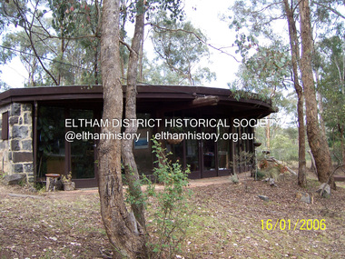 Eltham District Historical Society Inc
Photograph - Digital Photograph, Marguerite Marshall, Former office of Alistair Knox, King Street, Eltham, 16 January 2006
Situated in King Street, Eltham, Alistair Knox built his home and office in 1962-1963 with mud-bricks made from the local soil and recycled materials blending the house with bush around it. Knox popularised the Eltham earth building movement, begun by Montsalvat founder, Justus Jorgensen. Alistair Knox (1912-1986) was also an Eltham Shire Councillor 1971-1975 and Shire President in 1975. He established the inaugural Eltham Community Festival in 1975. Covered under Heritage Overlay, Nillumbik Planning Scheme. Published: Nillumbik Now and Then / Marguerite Marshall 2008; photographs Alan King with Marguerite Marshall.; p145This collection of almost 130 photos about places and people within the Shire of Nillumbik, an urban and rural municipality in Melbourne's north, contributes to an understanding of the history of the Shire. Published in 2008 immediately prior to the Black Saturday bushfires of February 7, 2009, it documents sites that were impacted, and in some cases destroyed by the fires. It includes photographs taken especially for the publication, creating a unique time capsule representing the Shire in the early 21st century. It remains the most recent comprehenesive publication devoted to the Shire's history connecting local residents to the past. nillumbik now and then (marshall-king) collection, alistair and margot knox house, alistair knox design, mudbrick construction, eltham, king street -
 Eltham District Historical Society Inc
Photograph - Digital Photograph, Alan King, Pigeon Bank, Kangaroo Ground-Warrandyte Road, Kangaroo Ground, 6 February 2008
In 1848, Francis Rogerson form Dumfriesshire, Scotland purchased 80 acres of land at Kangaroo Ground on which he built a two-roomed bark hut. He named the property afterr the many Bronzewings and Wonga Pigeons in the area. Ewen Hugh Cameron moved to Pigeon Bank the same year he was elected to Parliament as the Member for Evelyn. At the time he moved in, Pigeon Bank had six rooms and the present water well. He made further extensive additions and lived there until his death in 1915. Covered under Heritage Overlay, Nillumbik Planning Scheme. Published: Nillumbik Now and Then / Marguerite Marshall 2008; photographs Alan King with Marguerite Marshall.; p27 Pigeon Bank, on the Kangaroo Ground – Warrandyte Road, Kangaroo Ground, is one of the Shire’s oldest farm dwellings, and has been home to some of the district’s earliest and most distinguished families. Although close to the road, the white weatherboard Victorian farmhouse is ensured privacy by the trees and hedges around it. On 4.8 hectares of farmland, Pigeon Bank is surrounded by rolling hills, farmland and bush, the peace of which is punctuated by an occasional birdcall. Pigeon Bank’s first owner was Francis Rogerson, from Dumfriesshire, Scotland, who bought 80 acres (32.4ha) of land in 1848 on which he built a two-roomed bark hut. Today this is the centre piece of the 14-room home.1 Rogerson lined the rooms with tongue-and-groove boards and roofed them with wooden shingles and sapling frames, which remain under the present green corrugated iron roof. He named Pigeon Bank after the many forest bronzewing and Wonga Pigeons in the area at the time, and the name Bank was commonly used in Scotland. Rogerson was united with one of the oldest families in the area when his sister Janet married John Bell, son of William, the original Bell settler. When Ewen Cameron moved to Pigeon Bank in 1874 it had six rooms and the present water well. He made extensive additions to the house and farm buildings and lived at Pigeon Bank until his death in 1915. Cameron, who had arrived in Melbourne from Scotland in 1853, contributed an enormous amount to the community. He worked as a builder, as a miner at Andersons Creek, a storekeeper at Queenstown2 and as the first postmaster at Warrandyte. In 1867 he married Agnes Bell, daughter of local farmer, John Bell. Cameron was a member of the Eltham Road Board (which preceded the Shire Council) and for more than 50 years, from 1863, he was an Eltham Shire Councillor, being President three times. Cameron was the Member for Evelyn for 40 years from 1874. In the 1880s he became the Government Whip, in 1902 the Minister for Mines and Water Supply, and in 1904, the Minister for Health, Cameron was also an outstanding farmer, whose farm won the Agricultural Department prize for the finest in the district, three consecutive times. Not surprisingly Pigeon Bank became the centre of district life. Every New Year’s Eve, Cameron hired a highland piper, who marched from the Kangaroo Ground school house to Pigeon Bank playing his pipes.3 Distinguished visitors included opera singer, Dame Nellie Melba, Victorian Premier, Thomas Bent, Governor, Lord Hopetoun and artist, Longstaff. Following Cameron’s death, the property changed hands several times, then returned to the family in 1919 when bought by Gordon Cameron. As the car took over from the horse, Pigeon Bank entered difficult times because the farm had produced chaff and oats and bred Clydesdales and harness ponies. In 1926 Mr Matthews bought the property and made many alterations including pulling down the kitchen, which had been separate from the main house. The property again changed hands several times. One owner was Senator James F Guthrie, who added a sunroom. In 1968 the house again returned to the Cameron family, when Vera Jackson, a grand-daughter of Ewen Cameron, and her husband, bought the property. The Bishop family, who were sixth and seventh generation Bells and also descended from the Camerons, restored the house in the 1980s. Today tongue-and-groove boards still line part of the hall (which retains two fine arches), the breakfast room, and Ewen Cameron’s former room. Five original fireplaces in the bed and living rooms are still in working order. The wide veranda with a curved iron roof and ornate iron lace work bounds three sides of the house, and nearby a windmill stands beside the water well. Sue and Ron James, who bought the property in 2001, made extensive improvements to the homestead and meticulously restored the grounds to their original state.This collection of almost 130 photos about places and people within the Shire of Nillumbik, an urban and rural municipality in Melbourne's north, contributes to an understanding of the history of the Shire. Published in 2008 immediately prior to the Black Saturday bushfires of February 7, 2009, it documents sites that were impacted, and in some cases destroyed by the fires. It includes photographs taken especially for the publication, creating a unique time capsule representing the Shire in the early 21st century. It remains the most recent comprehenesive publication devoted to the Shire's history connecting local residents to the past. nillumbik now and then (marshall-king) collection, ewen hugh cameron, francis rogerson, kangaroo ground, kangaroo ground-warrandyte road, pigeon bank -
 Eltham District Historical Society Inc
Photograph - Digital Photograph, Alan King, Graves of Thomas Sweeney and family, Eltham Cemetery, Victoria, 27 January 2008
The grave of Thomas Sweeney, former convict turned respectable citizen. The Murray and Sweeney families were both early settlers of the Eltham district and connected by marriage. Their family plots are located side by side in the Catholic section of the Eltham Cemetery. Irish-born Thomas Sweeney is regarded as the first settler in Eltham. He was transported to Sydney in 1823 after being convicted of arson. He was granted his freedom in 1838 and married Margaret Meehan in the same year. They moved to Melbourne and in 1842 Thomas purchased 110 acres beside the Yarra River in the vicinity of present-day Sweeneys Lane. He called the property ‘Culla Hill’ and built a small slab hut (reputedly with Wurundjeri help; Margaret is said to have run an informal hospital for them in return). This was followed in 1846 by more substantial buildings consisting of a three-roomed Irish-style ‘longhouse’ and a barn made of stone and handmade bricks, with doors large enough to accommodate a fully loaded wagon. When the gold rush came, Thomas prospered by selling meat and potatoes to the prospectors, enabling him to purchase a further 308 acres in 1856. He promoted the construction of a bridge over the Plenty River and the establishment of a school at Eltham. Roman Catholic Church services were held at Culla Hill in the early years. When he died in 1867, he was regarded as a respected member of the community. Thomas and Margaret are buried in Eltham Cemetery with many of their descendants. Their first son John continued to farm Culla Hill until his death in 1909. Culla Hill passed out of the Sweeneys' possession in 1939. The house and barn remain today, though lesser outbuildings have gone. The facade of the house is much the same as it was in the 1840s. Sacred To the memory of Thomas Sweeney Who died Sep 6th 1867 Aged 65 years May his soul res in peace Also his wife Margaret Died Oct 3rd 1884 aged 73 years And their daughters Annie Died Aug 22nd 1860 aged 21 years Johanna Died Aug 19th 1872 aged 22 years Margaret Died 7th Sep 1913 aged 72 years R.I.P. Also In Memory Of John Sweeney Died 24th May 1909 Aged 65 years Also of his wife Ellen Died 8th March 1910 Aged 64 years R.I.P Also In Memory Of Caroline Infant daughter of John & Ellen Sweeney Published: Nillumbik Now and Then / Marguerite Marshall 2008; photographs Alan King with Marguerite Marshall.; p55 From the piety and poverty of 19th century Eltham, 20th century artists and environmentalists, to today’s comfortable middle class, Eltham Cemetery records it all — and more. A visit to Eltham Cemetery reveals an important social record since its beginnings in 1858. The cemetery was situated on about six acres (2.4ha) (now around 4.8ha) at the corner of Mount Pleasant and Metery Roads.1* It is thought that Metery Road was originally called Cemetery Road, but in the early 1940s, a resident, possibly a councillor, objected to the name resulting in the change.2 Much can be gleaned about the developing Eltham community from burial styles and the names of former local residents. Originally the cemetery was divided into Christian denominations, like others of that time, following the United Kingdom burial system. In 1861 the cemetery included Church of England, Presbyterian, Roman Catholic and Wesleyans (later Methodist) sites. Graves also indicated social class. Some had grand tombstones, perhaps fenced with ornamental cast iron railing, but most in the 1860s and 1870s were constructed of modest stone slabs.3 This indicated the poverty of the district, which was largely inhabited by farmers on small landholdings. A poignant reminder of the high rates of infant mortality of those times, are the many infants and young children recorded on the headstones. Major changes occurred in the cemetery in the late 20th century as Christian adherence weakened and society became more egalitarian and informal. In the early 1970s a non-denominational lawn section for burials was established. Since then all new areas have been non-denominational to accommodate the more diverse local community. Now, instead of large ornamental headstones, some mourners have chosen boulders, reflecting the natural Eltham style, while others choose graves in the lawn areas or niches in walls. In the late 1970s, the University Donor Section was established north-west of Candlebark Lawn for those who donated their bodies for The University of Melbourne medical research. In the early 1980s the natural Australian garden style, popular in Eltham, was mirrored in a new section called Ashes Walk. Local landscape architect Gordon Ford, who had popularised this style, designed the Walk using boulders shaded by native plants beside curved pathways. Landscape architect Robert Boyle later redesigned Ashes Walk and developed other parts of the cemetery in keeping with this style.4 Appropriately Ford, who died in 1999, was interred in the Native Garden Section in a cluster of sites shaded by a large eucalyptus tree.5 By 2007, about 6400 interments were recorded in the Eltham Cemetery. Close inspection reveals notable names in the district’s history. The grave of Thomas Sweeney, a former convict who became a respected citizen, can be found in the Roman Catholic section near the path. Eltham Primary School’s first headmaster, David Clark, is buried in a modest grave in the Church of England section to the east of the path from the main entrance. Sir William Irvine, Victorian Premier from 1900 to 1902, whose grave is in the north-east Presbyterian section was at various times Victoria’s Chief Justice, Deputy Governor and Treasurer.6 Further south is the grave of social reformer Bertram Wainer, born in Scotland in 1928 and died in 1987. He campaigned to legalise abortion and exposed police corruption in allowing illegal ‘backyard’ abortions. Other prominent local residents interred in the cemetery include: Justus Jörgensen, who founded Montsalvat; Alistair Knox, the mud-brick housing pioneer and Eltham Shire Councillor from 1971 to 1975 and President in 1975; Clem and Nina Christensen, who had a major influence on the literary development of post World War Two Australia. Others were: composer Dorian Le Gallienne; artist Peter Glass; Stephen Dattner, a prominent Melbourne furrier; ALP parliamentarian for Greensborough, Pauline Toner and political scientist and commentator, Professor William Macmahon Ball.This collection of almost 130 photos about places and people within the Shire of Nillumbik, an urban and rural municipality in Melbourne's north, contributes to an understanding of the history of the Shire. Published in 2008 immediately prior to the Black Saturday bushfires of February 7, 2009, it documents sites that were impacted, and in some cases destroyed by the fires. It includes photographs taken especially for the publication, creating a unique time capsule representing the Shire in the early 21st century. It remains the most recent comprehenesive publication devoted to the Shire's history connecting local residents to the past. nillumbik now and then (marshall-king) collection, annie sweeney, caroline sweeney, ellen sweeney, eltham cemetery, graves, gravestones, johanna sweeney, john murray, john sweeney, margaret sweeney, mary ellen drain, mary murray, thomas murray, thomas sweeney -
 Eltham District Historical Society Inc
Photograph - Digital Photograph, Marguerite Marshall, Strathewen Public Hall, 20 August 2008
Strathewen Public Hall, social and spiritual centre was later lost in the Black Saturday fires 2009. The Strathewen Community decided a community hall was needed in 1901. In 1902 locals built the hall with messmate trees. It was located on the Cottlesbridge-Strathewen Road. The first function was a Grand concert and Balll attended by about 120 people. Several denominations held Church services and Sunday School services in the Hall. It survived several bushfires until after this photo was taken when it was destroyed in Black Saturday, 9 February 2009. Published: Nillumbik Now and Then / Marguerite Marshall 2008; photographs Alan King with Marguerite Marshall.; p89 Strathewen was settled late, largely because it was difficult to access.1 Early selectors found it a struggle to survive. They had to do everything themselves, from felling trees for buildings, to taking produce to market along bush tracks that they had helped cut. Small dairy farms were typical but fruit became the district’s prime produce. The first settlers east of Arthurs Creek were brothers John and Duncan Smith whose station Glen-Ard was probably operated as a sheep run. Other early settlers were the Mann family, who were to donate land for the hall, provide postal services and John Mann was an Eltham Shire councillor from 1916 to 1919.2 In 1873 James Mann, his wife Jane and their six children, settled on 207 acres (83.7) (Lang Fauld Farm) on both sides of Eagles Nest Road, from the foot of Mount Sugarloaf to the bank of the Arthurs Creek. In 1883 James took up another selection on Chads Creek. It was very hard work and at times he was well behind with his rent. However the family had a good social life, attending the Primitive Methodist Church at the Arthurs Creek Township and on New Year’s Eve throwing a party for all the locals. By 1874 James Mann’s younger brother, John, selected 311 acres (125.8ha) between Eagles Nest Road and upper Arthurs Creek. He called it Carseburn after his home parish in Scotland. Tragically in 1875 John drowned in the Yarra River, at Richmond.3 John Mann’s oldest son, also John, later purchased Duncan Smith’s land, which he named Violet Glen. He was to give one acre (0.4ha) of this land for the Strathewen Hall site. A Mann family diary written at Carseburn in 1897, tells how the district’s name was selected. Strathewen is derived from ‘strath’ meaning ‘broad mountain valley’ and from the name of Ewen H. Cameron, the local parliamentarian for almost 40 years. ‘George Brain came around to get a petition signed to get a post office up here and we had to vote for a name—Strathewen, Glen-Ard, or Headcorie’.4 It was at Carseburn that a public meeting in 1901, decided to build the Strathewen Hall on the Cottlesbridge-Strathewen Road. In 1902 the locals built the hall with messmate trees. The first function was a Grand Concert and Ball attended by around 120 people and several Protestant denominations took turns to hold church services and Sunday School there. Fortunately the hall has survived bushfires to be the town’s spiritual and social centre.5 The area continued to develop and in 1909 a post office operated somewhere at Strathewen and from around 1916 at Carseburn.6 It was not until 1914 that land was bought to establish the Strathewen State School on School Ridge Road. The residents paid £100 to build it on two acres (0.8 ha) while the Education Department contributed £30 and leased the building annually for £1. When teacher Miss Mary Golding opened the school in 1917, it had no equipment.7 But in 1921 the Education Department provided desks and a hexagonal shelter shed (now a rare style in Victoria) and took control in 1925.8 By 1917 Strathewen was booming.9 George Apted had built a coolstore in 1916, and local orchardists bought storage space until the 1950s. This allowed the area to supply the market in and out of season. Guesthouses catered for growing tourism. In the mid 1920s Mrs Eleanor Sparkes built the guest-house Singing Waters, which operated through the 1930s. Her daughter Mrs Vera McKimmie, ran it until the 1950s and the house remains in Chads Creek Road. In the Great Depression land was cleared for timber to be sold as firewood and there was small scale sawmilling. However the orchard industry diminished for several reasons including the 1939 bushfires and rapid changes in production methods. Today the Apteds still operate an orchard and farm at Glen-Ard, which straddles the border between Strathewen and Arthurs Creek. It includes the southern part of Duncan Smith’s original Glen-Ard selection.This collection of almost 130 photos about places and people within the Shire of Nillumbik, an urban and rural municipality in Melbourne's north, contributes to an understanding of the history of the Shire. Published in 2008 immediately prior to the Black Saturday bushfires of February 7, 2009, it documents sites that were impacted, and in some cases destroyed by the fires. It includes photographs taken especially for the publication, creating a unique time capsule representing the Shire in the early 21st century. It remains the most recent comprehenesive publication devoted to the Shire's history connecting local residents to the past. nillumbik now and then (marshall-king) collection, strathewan public hall -
 Eltham District Historical Society Inc
Photograph - Digital Photograph, Alan King, Eltham Railway Trestle Bridge, 28 December 2007
Covered under National Trust of Australia (Victoria) State Significance and Heritage Overlay, Nillumbik Planning Scheme. Published: Nillumbik Now and Then / Marguerite Marshall 2008; photographs Alan King with Marguerite Marshall.; p103 The Eltham railway trestle bridge is the only one of its kind still regularly used in Melbourne’s metropolitan railway network. Opened in 1902, it is also one of Victoria’s very few timber rail bridges that still carries trains.1 The bridge is part of the railway line extension from Heidelberg - extended to Hurstbridge in 1912. This extension resulted in one of the greatest social changes experienced in Eltham Shire, as it considerably lessened its isolation attracting tourists, artists and suburban commuters particularly after World War Two.2 The bridge has been classified by the National Trust as historically, scientifically, aesthetically and socially significant at state level. But this has not always been recognised, and in 1977, locals fought to save it from destruction. The Victorian Railways proposed to replace the bridge with an earth embankment and large culverts to avoid maintenance problems and fire. This was rejected by the Eltham Council who protested that the bridge helped maintain the area’s rural character, historic link and beauty, as well as avoiding possible serious flooding on the flood plain if a culvert was blocked. The bridge stands as part of a National Trust classified landscape which includes the Alistair Knox Park, named after the local conservationist and architect who helped to make Eltham famous for its mud-brick houses. The landscape includes tall and spreading manna gums and candlebarks, and the historic Shillinglaw Cottage. Artist Walter Withers, one of the Heidelberg School of painters, painted the bridge early in the 20th century. The 38 span single-track railway bridge over creek and road has 34 timber-beam spans and four steel-joist spans, supported by four-pile timber piers and timber abutments. It has almost 200m of timber deck. All of the timbers have been replaced over the years, but the only change to the bridge’s character was the addition of pylons and wiring for electric trains in 1923. A petition for a railway to the shire was first made in 1883. A large deputation of local citizens to the Commissioner of Railways proposed a route passing through Alphington to midway between Greensborough and Eltham up the Diamond Creek valley towards Queenstown and Kinglake. As a result the Princes Bridge-Heidelberg Railway was opened in 1888. From 1888 locals demanded a railway extension. Kangaroo Ground farmers in particular, led by Shire Councillor and Member for Evelyn, Ewen Cameron, said it would assist local farmers and orchardists send their produce to the Melbourne market. In 1890, before the severe economic Depression, an extension of the line to Hurst’s Bridge (now Hurstbridge) was included in a new Railways Bill. The parliamentary delegations were regaled with a banquet at Hurst’s barn and entertained by the Diamond Creek Brass Band, but the extension was abandoned when the Depression struck in 1892-1893. The extension of the railway to Eltham, completed in 1902, was one of the few built in those hard times. That is why the Eltham timber-trestle railway bridge is a rare example of a broad-gauge rail bridge constructed between 1893 and 1910. At the opening, despite persistent drizzle, 300 children waving flags and banners were among the large crowd welcoming the first train, carrying official dignitaries, to Eltham. It had taken 24 years to bring the railway to Eltham. From then Eltham became a popular destination for outings. Mr Orford of Eltham recalled that after the railway came to Eltham ‘the craze for picnics on weekends and holidays began…. During the wattle season, wattle trains came to Eltham frequently. The visitors roamed the creek pulling great armfuls of wattle blossom to take back with them to Melbourne’.3 In 1926 the railway line was electrified as part of the metropolitan rail network. But the Victorian Railways decided not to complete the formerly planned Diamond Valley Railway to Queenstown (now St Andrews) and Kinglake.This collection of almost 130 photos about places and people within the Shire of Nillumbik, an urban and rural municipality in Melbourne's north, contributes to an understanding of the history of the Shire. Published in 2008 immediately prior to the Black Saturday bushfires of February 7, 2009, it documents sites that were impacted, and in some cases destroyed by the fires. It includes photographs taken especially for the publication, creating a unique time capsule representing the Shire in the early 21st century. It remains the most recent comprehenesive publication devoted to the Shire's history connecting local residents to the past. nillumbik now and then (marshall-king) collection, eltham railway trestle bridge, eltham trestle bridge -
 Eltham District Historical Society Inc
Photograph - Digital Photograph, Marguerite Marshall, Former home of Alistair and Margot Knox, King Street, Eltham, 16 January 2006
Situated in King Street, Eltham, Alistair Knox built his home and office in 1962-1963 with mud-bricks made from the local soil and recycled materials blending the house with bush around it. Knox popularised the Eltham earth building movement, begun by Montsalvat founder, Justus Jorgensen. Alistair Knox (1912-1986) was also an Eltham Shire Councillor 1971-1975 and Shire President in 1975. Knox established the inaugural Eltham Community Festival in 1975. Covered under Heritage Overlay, Nillumbik Planning Scheme. Published: Nillumbik Now and Then / Marguerite Marshall 2008; photographs Alan King with Marguerite Marshall.; p145 Lack of money was a strong incentive for Alistair Knox to do what he did best when he built his house and office at King Street, Eltham in 1962-63. He used mud-bricks from local soil and recycled materials, characteristically blending the house with the bush around it. The result was a work of art. Knox popularised the Eltham earth building movement,1 begun by Montsalvat founder Justus Jörgensen. He was also an Eltham Shire Councillor from 1971 to 1975 and Shire President in 1975. For Knox mud-brick building was not just a building style, but a spiritual experience and a way of relating with nature. At 40 he rediscovered God and his building reflected his theological, political, philosophical and particularly environmental world view, which was far ahead of its time.2 He also contributed to building development in his use of concrete slab foundations when stumps and bearers were the norm. Knox was introduced to mud-brick construction in 1940 by Jörgensen, then shortly after, Knox joined the Navy. In 1946 Knox studied Building Practice and Theory at Melbourne Technical College (now RMIT University). There he befriended fellow student and artist Matcham Skipper who belonged to what was then called the Jörgensen Artists’ Colony. Knox decided to build an earth building in Eltham, partly because the post-war huge building demands resulted in expensive and scarce building materials. He asked artist Sonia Skipper for help who, with Matcham, had constructed mud-brick buildings at the Artists’ Colony. The simple rectangular low-lying house at King Street is framed by native plants and a 3.6 metres wide pergola surrounds the building. Wedded to the landscape, a door in every room at the perimeter, opens outside. The property also includes a forge, a small hut built by son Macgregor at 15, and a mud-brick tower for chickens. Building materials were foraged from a wide variety of sources. Some of the joinery material came from old whisky vats. When the Oregon of the highest quality ‘was put through the wood-working machines, it gave off a deep smell of whisky that made the whole atmosphere exotic and heady’.3 Amateur builders, including schoolboys from Knox’s Presbyterian Church, made some of the mud-bricks. But the building was finished with the professional help of Yorkshire builder, Eric Hirst. Inside, the light is subdued with the mud-brick, beamed timber ceilings and floors of slate, timber or orange-brown tiles. Skylights, with rich blue and red leadlighting, illuminate one entrance area and this feature is repeated as edging on the door. The centre of the house is like a covered courtyard, with rooms built around it. The central room, 11 metres x 7 metres, was built in the same proportions as Knox’s mud-bricks. Clerestory windows on four sides infuse the room with a soft light. A huge brick fireplace extends beyond one corner and opposite is a small one where timber can only be placed vertically. The slate for the floor was discarded from the Malthouse Brewery now used as a theatre in Southbank. In the middle is a large refectory table and benches that seat 18. Like much of the house, it is rugged, yet beautiful. Made of Western Australian Jarrah by Macgregor with a chain saw and an adze, it retains knot and nail holes. Each wall has an opening, 2.4 metres at the ends and 3.6 metres at the sides. Only one has doors and these concertina doors are made of the backs of old church pews. The main bedroom has an ensuite with a marble hand basin discarded from the Victorian Parliament building; and a dressing room, where two wardrobes of polished timber recovered from a tip are attached to the walls. Separate from the house is the strikingly original circular-shaped office made of bluestone sourced from the original Army campsite at Broadmeadows.This collection of almost 130 photos about places and people within the Shire of Nillumbik, an urban and rural municipality in Melbourne's north, contributes to an understanding of the history of the Shire. Published in 2008 immediately prior to the Black Saturday bushfires of February 7, 2009, it documents sites that were impacted, and in some cases destroyed by the fires. It includes photographs taken especially for the publication, creating a unique time capsule representing the Shire in the early 21st century. It remains the most recent comprehenesive publication devoted to the Shire's history connecting local residents to the past. nillumbik now and then (marshall-king) collection, alistair and margot knox house, alistair knox design, mudbrick construction, eltham, king street -
 Eltham District Historical Society Inc
Photograph - Digital Photograph, Marguerite Marshall, St John's Anglican Church, Diamond Creek, 7 September 2008
The building was designed by Charles Maplestone of Heidelberg, son-in-law to Anthony Beale of St Helena. Maplestone was a prominent architect who came out to Australia with his family in 1852. The foundation stone was laid by Mrs Isabella Maplestone on 11th November 1867. The bricklayers for the church were George Stebbing, H Limmer, H Spicer and a Mr Timm while Thomas Day was the stonemason. Another three years were to pass before sufficient money could be raised for its completion. It was opened by Bishop Perry on 1st November, 1870. The church bell which hung under a tree for 50 years until it was incorporated in the parish hall was brought out from England and presented by Charles Orme. In 1916, the estate of George Martin Pizzey left sufficient money to build the red brick hall, which still stands today (2023) though in January 1969 the hall and bell tower were badly damaged by bushfire. Coincidentally the former home of benefactor, George Pizzey was destroyed in the same fire. Of particular significance are the interior and exterior of the church, the Sunday school and hall with emphasis on pre-World War I fabric (excluding the 1990s additions) and the three coloured glass windows currently suspended in the 1990s entry foyer. In 2011 further alterations were made to the front of the Church. The church is historically significant because it was the oldest public building in the former Diamond Valley Shire, is amongst the oldest buildings in the Shire of Nillumbik and is associated with the early settlement of the Diamond Creek district. The church is historically, socially and spiritually significant because it has been a place of worship for over 150 years and continues to be, an important meeting place in the Shire. The church is aesthetically significant for the three stained glass windows executed by the noted stained glass manufacturers, Ferguson & Urie, as well as the supporting coloured glass windows in the church. The Sunday school & parish hall is architecturally significant because the hall is a well executed and preserved example of the work of noted church architects, North & Williams. It is historically significant because it is connected with local parishioner and Melbourne industrialist, George Pizzey, who bequeathed funds for its construction. Covered under Heritage Overlay, Nillumbik Planning Scheme. National Estate Ntionl Trust of Australia (Victoria) Local significance Published: Nillumbik Now and Then / Marguerite Marshall 2008; photographs Alan King with Marguerite Marshall.; p85 St John’s Anglican Church stands like a beacon on the hill on Main Street, Diamond Creek. Today the church has a large congregation, but its early years were marked by a small congregation struggling to find enough money to survive. It was gold in Diamond Creek that resulted in the building of this National Trust registered property.1 This church is far removed from William Wilson’s humble barn (later the Bowling Green) where the first Anglican church services were conducted – probably the first in the district.2 In the mid 19th century services were infrequent as the Rev Francis Hales, travelling on horseback, also conducted services elsewhere, including at Heidelberg, Coburg, Kinglake, Arthurs Creek, St Andrews and Kangaroo Ground. In 1860 Diamond Creek came under the jurisdiction of the Eltham Parish. Until the mid 1860s the Diamond Creek settlement included only about 20 families who were struggling farmers. But this changed when gold was found in 1862. Then the township grew to 200 families, including miners, civil administration workers and shopkeepers. The resulting growth of Church of England adherents prompted them to petition the Government in 1866 for land to build a church. The area chosen, on which the original building still stands, was at the centre of the proposed township. Today church leaders believe that this conspicuous location is one of the reasons for its exceptional growth. Prominent architect Charles Maplestone designed the building as he did the Presbyterian Church at Kangaroo Ground. St John’s, which is still intact, was built in the Gothic Revival style with the traditional rectangular plan of a central nave and sanctuary at the end. It is typical of small churches built in Victoria at that time, with polychromatic hand-made bricks, a porch, diagonal buttresses and a slate roof.3 The church was officially opened by Lord Bishop Perry on November 1, 1870. But during the next 40 years, due to the varying fortunes of gold mining, the church struggled to remain viable. In 1909 it separated from the Eltham Parish to form a parish with Greensborough. Life became more difficult with the privations of World War One. Then disaster struck in 1915 when fire destroyed the Diamond Creek Gold Mine, wiping out the major livelihood of most parishioners. However the church’s morale was lifted in 1916, when it received a bequest to build the red brick hall, from late parishioner and prominent leather manufacturer, George Pizzey. As prosperity grew, in 1924 the congregation separated from Greensborough, but they rejoined in the 1930s Depression. In the 1950s the wider population soared, impacting on St John’s, and it became a separate parish, becoming responsible for six churches at St Andrews, Hazel Glen, Hurstbridge, St Helena and Yarrambat. As parishioner numbers outgrew the building, extensions were added in 1989 and then in 1993, blending in well with the original building. Church members have made a huge contribution to the local community. John Ryan was a Heidelberg Shire Councillor for 25 years from 1931, Mayor in 1939 and headed several local sporting and other organisations. His son Jock became a clergyman and a local historian heading the Nillumbik Historical Society. Another parishioner, Dr Ted Cordner, came to Diamond Creek in 1920. One of his sons Donald, who was a local doctor, won the Brownlow Medal, was President of the Melbourne Cricket Club and President of the Melbourne Grammar School Council. Roy ‘Monty’ Vale was a state Liberal MP and was related to May Vale, a member of the Heidelberg School of Artists.4 In the early 21st century St John’s Anglican Church is one of the fastest growing congregations in Melbourne. References: St Johns Anglican Church complex, Sunday School and Parish Hall 61 Main Street DIAMOND CREEK, NILLUMBIK SHIRE. (2023, June 7). Retrieved from https://vhd.heritagecouncil.vic.gov.au/places/64023 Diamond Creek, VIC. – St John’s Anglican (2023, June 7). Retrieved from https://www.churchhistories.net.au/church-catalog/diamond-creek-vic-st-johns-anglican This collection of almost 130 photos about places and people within the Shire of Nillumbik, an urban and rural municipality in Melbourne's north, contributes to an understanding of the history of the Shire. Published in 2008 immediately prior to the Black Saturday bushfires of February 7, 2009, it documents sites that were impacted, and in some cases destroyed by the fires. It includes photographs taken especially for the publication, creating a unique time capsule representing the Shire in the early 21st century. It remains the most recent comprehenesive publication devoted to the Shire's history connecting local residents to the past. nillumbik now and then (marshall-king) collection, st john's anglican church, diamond creek