Showing 37441 items
matching orbost-shire-council
-
 Greensborough Historical Society
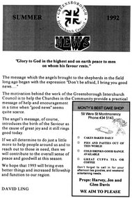
Pamphlet - Newsletter, Greensborough Inter Church Council, Greensborough Interchurch Council News. Summer 1992, 1992
The Greensborough Interchurch Council Newsletter (Summer 1992) reviews past activities and advertises coming events, including Christmas services at participating Churches.4 p., black text on cream paper.greensborough interchurch council, church services, newsletters -
![Booklet, Banyule City Council Services and Information [2000], 2000_](/media/collectors/4f729f5697f83e03086015b8/items/5a693f0321ea680e5c012824/item-media/5a6bb75b21ea6706ac6ffbf6/item-fit-380x285.jpg) Greensborough Historical Society
Greensborough Historical SocietyBooklet, Banyule City Council Services and Information [2000], 2000_
Banyule Council distributes this annual publication to all Banyule residents each year. It contains information on services and contacts within the Banyule area.40 pages, black text print on yellow backgroundbanyule, banyule city council -
 Robin Boyd Foundation
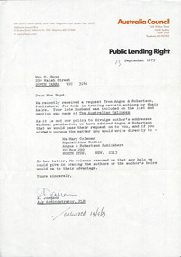
Letter, Australia Council, Australia Council to Patricia Davies, 13.09.1979
A letter from A. Johnson, Public Lending Right, Australia Council to Patricia Davies (formerly Boyd), regarding a request for tracing authors or their heirs.Answered 10/9/79 in pen. -
 Orbost & District Historical Society
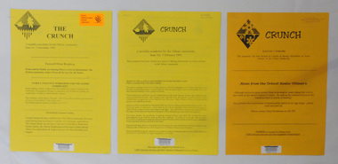
newsletters, The Crunch, 1995 1996
These newsletters were created as an ACCESS project at the Orbost centre of TAFE (Technical and Further Education). Community newsletters are published by local groups and provide community news and information. In small rural communities they are an important communication medium.Three issues of a newsletter titled The Crunch. This was a newsletter for the Orbost community and contains articles on Orbost events. Most articles refer to TAFE Outreach Services. 2407.1 and 2407.2 are printed on yellow paper. 2407.3 has 3 orange sheets and 2 yellow sheets. All are stapled. 2407.1 has a label on the front with East Gippsland Shire Library and a bar code. 2407.2 has a bar code and LOCAL Newsletter written in pencil. 2407.3 has a stamp - EAST GIPPSLAND LIBRARY SERVICE and LOCAL written in pencil.newsletters tafe-orbost -
 Koorie Heritage Trust
Book, Brady, Elsie, They left their footprints : the origin of the names of streets and parks within Shepparton also names of various facilities on Council properties, or properties under Council management, where names have been given by or approved by Council, 1996
152 p. : ill., maps ; 24 cm. 1. street names -- victoria -- shepparton. 2. shepparton (vic.) -- history. -
 Learmonth and District Historical Society Inc.
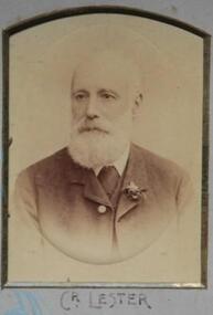
Photo -Lester, Richards & Co. Photos Ballaarat, Lester, Councilor, 1893 - 1894, 1894 (estimated)
Photo of Councilor John Lester,1893-1894.Part of composite photo of Councilors for that year.Councilor Lester was elected to council in 1886-1906, and was President in1888-89,1895-96and 1901-02.Section of Original Historic Photo of Councilors covering the financial year 1893-1894.Sepia photo,on blue background,of Councilor John Lester, second row right hand side of composite photo of Councilors for the year 1893-1894.Shire President and Councilors for the year 1893-1894.1893 1894, ballarat shire council, lester john -
 Eltham District Historical Society Inc
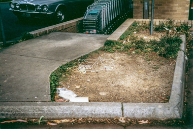
Photograph - Colour Print, Eltham Shire Council, Litter, Luck Street carpark, Eltham, c.1988
Luck Street Carpark near entrance to Frankllin's Supermarket, now present-day Dan Murphy's store, One of a series of 6 images taken by Eltham Shire Council officers recording litter being prevalent around the shopping precinct and carparks spreading from Luck Street through Commercial Place top Arthur Street, Elthamarthur street, car park, carparks, commercial place, eltham shopping centre, eltham shops, litter, luck street, dan murphy's, franklins supermarket -
Southern Sherbrooke Historical Society Inc.
Newsletter, "Shire of Yarra Ranges Community Bulletin", June 1999 (exact)
Free newsletter distributed to residents of the Shire of Yarra Ranges, detailing activities, etc.shire of yarra ranges -
 Greensborough Historical Society
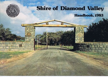
Book, Shire of Diamond Valley Handbook 1983, 1983_
Guide to services provided by Shire of Diamond Valley. The Shire of Diamond Valley was a Local Government Area located about 20 kilometres northeast of Melbourne. The shire covered an area of 74.38 square kilometres and existed from 1964 until 1994.Annual guide to services in Shire of Diamond Valley32 pages, col illus., maps. Cover illustration of the bluestone gateway, main entrance to Yarrambat Park, opened 1982.shire of diamond valley, greensborough, handbooks -
 Greensborough Historical Society
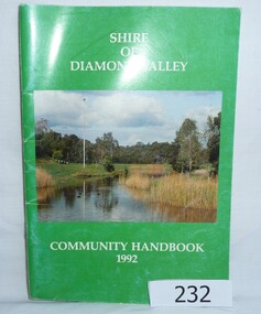
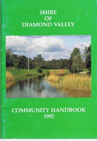
Book, Shire of Diamond Valley Community Handbook 1992, 1992_
Guide to services provided by Shire of Diamond Valley. The Shire of Diamond Valley was a Local Government Area located about 20 kilometres northeast of Melbourne. The shire covered an area of 74.38 square kilometres and existed from 1964 until 1994.Annual guide to services in Shire of Diamond Valley52 pages, col illus., maps. Cover illustration of Kalparrin Gardens Greensboroughshire of diamond valley, greensborough, handbooks -
 Greensborough Historical Society
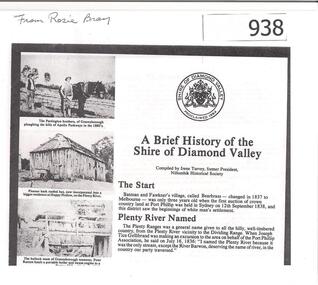
Article, Shire of Diamond Valley, A brief history of the Shire of Diamond Valley by Irene Turvey, 1837o
This brief history discusses the Shire of Diamond Valley. The Shire of Diamond Valley was a Local Government Area located about 20 kilometres northeast of Melbourne. The shire covered an area of 74.38 square kilometres and existed from 1964 until 1994.This article includes some images of early building in the Shire of Diamond Valley.Photocopied article. 4 pages text and illus.On front page "from Rosie Bray"shire of diamond valley, irene turvey -
 Greensborough Historical Society
Book, Shire of Diamond Valley, Shire of Diamond Valley Community Handbook 1992, 1992_
Guide to services provided by Shire of Diamond Valley. The Shire of Diamond Valley was a Local Government Area located about 20 kilometres northeast of Melbourne. The shire covered an area of 74.38 square kilometres and existed from 1964 until 1994.Annual guide to services in Shire of Diamond Valley52 pages, col illus., maps. Cover illustration of Kalparrin Gardens Greensboroughshire of diamond valley -
 Orbost & District Historical Society
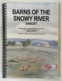
book, Barns of the Snowy River Orbost, 2006
This is a book written by a local historian containing historical information pertaining to Orbost and the surrounding district. A spiral bound book of 191pp. On the front and back covers are coloured print of the Morgan Barn c 1900, an original watercolour, artist unknown. The book documents the distinctive slatted barns of the lower Snowy River, Orbost, Victoria. The book was published by the Orbost Historical Society and was written by May Leatch and Ngaere Donald. It contains B/w photographs, drawings and stories of the barns and their histories.history-agriculture-orbost barns-slatted -
 Learmonth and District Historical Society Inc.
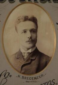
Photo - Bregenzer, Richards & Co. Photos Ballaarat, H.Bregenzer, Secretary.1885-86, "Circa 1886"
Mr H. Bregenzer was Secretary of the Ballarat Shire Council for the council year 1885-86Section of Original Historic Photo of councilors and staff for the year 1885-86Sepia photo of Mr. H. Bregenzer is in the middle at the bottom of collection of photos of all councilors for 1885-86. It is oval in dark grey mount edged in gold. " PRESENTED BY THE PRESIDENT G.RENNIE ESQ.TO THE BALLARAT SHIRE COUNCIL.1885-86."1885 1886, ballarat shire council, bregenzer h secretary -
 Greensborough Historical Society
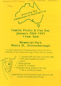
Flyer - Article and Leaflet, Greensborough Inter Church Council, Greensborough Interchurch Council. Family picnic and fun day 26/01/1995, 26/01/1995
The Greensborough Interchurch Council organised a family picnic and fun day on Australia Day 26/01/1995. Leaflet advertising the event and article by Rosie Bray2 p. Leaflet: blue text on yellow paper; article: black text on white papergreensborough interchurch council, australia day, picnics in greensborough -
 Eltham District Historical Society Inc
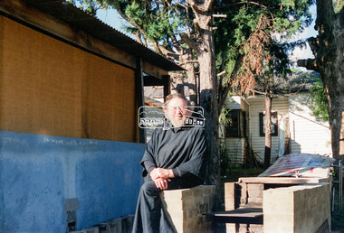
Negative - Photograph, Eltham Shire Council, Possibly a non-compliant house in Simms Road, Kinglake, c.1989
Facebook comments suggested this location may be a cabinetmaker by the name of Cook out the back of Panton Hill. Another comment recalled this man as a visitor to Montsalvat as a friend of the late poet, Geoffrey Egglestone. It is believed his name is Mizza. He is a Bohemium Poet. Also a frequent visitor to the St Andrews market. Photos taken by Eltham Shire Council officers most likely during an inspection of the property for non compliance. Other images on the roll of film are of Council Health officers undergoing food inspections at the shops, maternal health services and housing estate development inspectionsRoll of 35mm colour negative film, 6 strips Frames 3 through 9Fuji 100eltham shire council, shire of eltham, 1989, atlantic ethyl, sheds, signs, unidentified, houses, kinglake, simms road -
 Orbost & District Historical Society
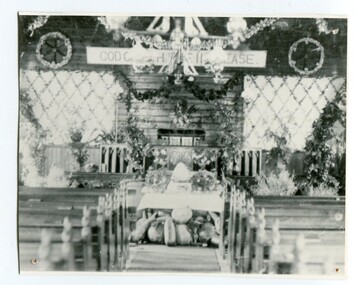
black and white photograph, C1900
The first Orbost Presbyterian Church was opened on January 9 1898. It was built by Mr R. P. Cameron for three pounds. The Harvest Festival display was always put together by the church ladies. The Festival was a family friendly festival celebrating the end of summer.This item is reminiscent of the late 19th - mid 20th centuries when church-going was more common.A black / white photograph of inside the Orbost Presbyterian Church decorated with rural produce and flowers for the "Harvest Festival". It is on a white buff card with a blue photographer's stamp in the bottom left hand corner.on front - stamp -" Herbert Sherwood" on back - "M. Gilbert, Orbost" - "Mrs J. Sterling, 6 Marine Parade , Elwood"church-presbyterian-orbost harvest-festival -
 Learmonth and District Historical Society Inc.
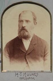
Photo - Hughes, Richards & Co. Photos Ballaarat, Hughes. H.T. Councilor 1893 - 1894. (Rate Collector), 1894 (estimated)
Photo of Councilor H.T.Hughes, Rate Collector for the year 1893 -1894.Part of composite photo of Councilors for that year.Section of Original Historic Photo of Councilors covering the financial year 1893 - 1894.Sepia photo,on blue background,of Councilor H.T.Hughes,Rate Collector. Bottom right hand corner of composite photo of councilors for the year 1893 - 1894.Shire President and Councilors for the year 1893 -1894.shire, ballarat, council, 1893, 1894, hughes h t -
 Sunshine and District Historical Society Incorporated
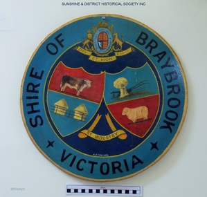
Plaque, A. H. Walker, COAT OF ARMS - Shire of Braybrook Victoria, Unknown date of manufacture
From around circa 1850 Braybrook was already well established and became a staging point for prospectors on their way to the diggings. Local government for this rural area to the west of Melbourne came when the BRAYBROOK ROAD DISTRICT was proclaimed on 28 May 1860. This authority was superseded on 23 January 1871 with the formation of the SHIRE OF BRAYBROOK. The Shire of Braybrook existed for about 80 years during which time it experienced significant industrial growth. The Shire of Braybrook ceased to exist in 1951 when the CITY OF SUNSHINE was formed.The Coat of Arms informs the observer that the Shire of Braybrook was initially a rural area with its images of a cow, sheep, and hay. The reference to industry however probably does not indicate adequately the large growth in industrial activity that occurred within the Shire. Circular board of Masonite painted by A. H. Walker which is a true depiction of the Coat of Arms for the Shire of Braybrook. It is mainly blue, yellow and red coloured with black writing, and has images of a cow, sheep, and hay, and also indicates a reference to industry.Shire of Braybrook Victoria / Dieu Et Mon Droit / By Industry / A. H. Walkercoat of arms, shire of braybrook, a. h. walker, plaque, sunshine -
 Eltham District Historical Society Inc
Document, OCM.004/12 Interim relocation of the Eltham Cenotaph; 11. Officer's reports, Ordinary Meeting of Council Agenda, 31 January 2012, pp16-19 and Attachment 1; OCM.004/12 Interim relocation of the Eltham Cenotaph; Funding Agreement Between Nillumbik Shire Council and Montmorency - Eltham RSL Sub Branch Inc., 31 January 2012, pp16-19, 2012
Relocation of the Eltham Cenotaph following the collapse of the Eltham RSL Sub-Branch9 A4 pages printedeltham cenotaph, eltham war memorial, montmorency-eltham rsl sub-branch, nillumbik shire council -
 Eltham District Historical Society Inc
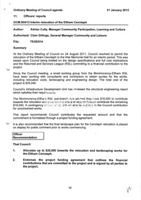
Photograph, Old Eltham Shire Council towed grader at the Council Depot, Hurstbridge
Roll of 35mm colour negative film, 2 stripsFuji 100eltham shire council, equipment, grader-towed, graders, roadmaking, trailers, shire of eltham -
 Eltham District Historical Society Inc
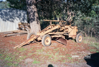
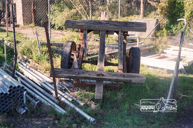
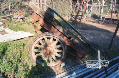
Photograph, Old Eltham Shire Council trailer at the Council Depot, Hurstbridge
Roll of 35mm colour negative film, 2 stripsFuji 100eltham shire council, equipment, trailers, shire of eltham -
 Eltham District Historical Society Inc
Photograph, Old Eltham Shire Council trailer at the Council Depot, Hurstbridge
Roll of 35mm colour negative film, 2 stripsFuji 100eltham shire council, equipment, trailers, shire of eltham -
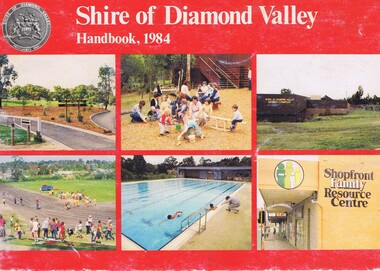 Greensborough Historical Society
Booklet, Shire of Diamond Valley Handbook 1984, 1984_
Guide to services provided by Shire of Diamond Valley. The Shire of Diamond Valley was a Local Government Area located about 20 kilometres northeast of Melbourne. The shire covered an area of 74.38 square kilometres and existed from 1964 until 1994. Cover illustration of recreation facilities in Diamond Valley.Annual guide to services in Shire of Diamond Valley32 pages, col illus., maps. 2 copies.shire of diamond valley, greensborough, handbooks -
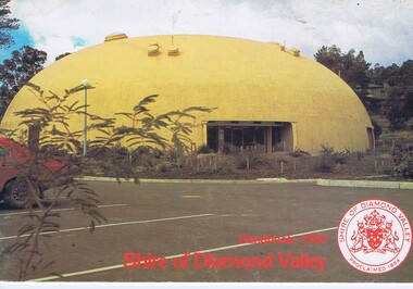 Greensborough Historical Society
Booklet, The Shire of Diamond Valley Handbook 1981, 1981_
Guide to services provided by Shire of Diamond Valley. The Shire of Diamond Valley was a Local Government Area located about 20 kilometres northeast of Melbourne. The shire covered an area of 74.38 square kilometres and existed from 1964 until 1994. Cover illustration of "Diamond Creek Bini-shell".Annual guide to services in Shire of Diamond Valley28 pages, col illus., maps. (3 copies)shire of diamond valley, greensborough, handbooks -
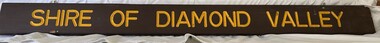 Greensborough Historical Society
Sign, Shire of Diamond Valley, Shire of Diamond Valley: Park or Reserve sign, 1964-1994
Shire of Diamond Valley timber sign. This sign would have been at the entry to one of the many public parks and reserves created during the time of the Shire of Diamond Valley (1964-1994). Following the redistribution of local government areas in 1994, the previous Shire of Diamond Valley was split between City of Banyule and Shire of Nillumbik. Signage would have been replaced to reflect the new 'owners' of the property. The exact location of this sign is unknown.Brown painted Timber sign with yellow writing etched into timbershire of diamond valley, sign, parks - greensborough -
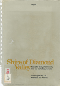 Eltham District Historical Society Inc
Book - Report, Gunn Hayball Pty Ltd Architects and Planners, Shire of Diamond Valley, Feasibility Study of Community Arts and Crafts Requirements, 1977
This report was prepared in response to a brief issued by the Shire of Diamond Valley to investigate the requirements for arts/crafts in the Shire and suggest options available in satisfying those requirements.Ex Yarra Plenty Regional Library - Local History, Dewey labels and catalogue stamp inside rear covershire of diamond valley, community arts and crafts, feasibility study -
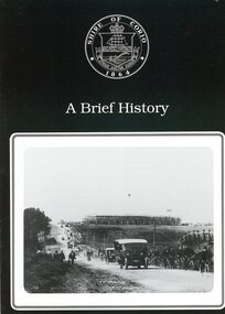 Greensborough Historical Society
Booklet, Shire of Corio, A Brief history of the Shire of Corio, 1980s
History of Shire of Corio, a local government area between Geelong and Werribee. The Shire included all of Geelong's northern suburbs and existed from 1861 to 1993.12 p., printed in green on white paper, photographs, stapled.geelong, shire of corio, werribee -
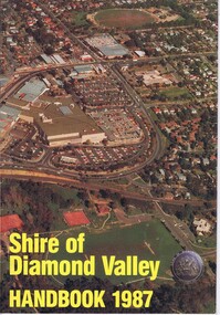 Greensborough Historical Society
Booklet, Shire of Diamond Valley Handbook 1987, 1987_
Guide to services provided by Shire of Diamond Valley. The Shire of Diamond Valley was a Local Government Area located about 20 kilometres northeast of Melbourne. The shire covered an area of 74.38 square kilometres and existed from 1964 until 1994. Cover illustration of aerial view of Greensborough shopping area and environs.Annual guide to services in Shire of Diamond Valley32 pages, col illus., maps. 2 copies.shire of diamond valley, greensborough, handbooks -
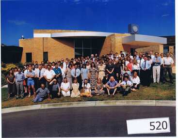 Greensborough Historical Society
Photograph (Framed), Shire of Diamond Valley, Shire of Diamond Valley Staff. Last day 1992, 1992_12
Photograph of "indoor" staff, Shire of Diamond Valley, on their last day at work for the Shire.The Shire of Diamond Valley was a Local Government Area located about 20 kilometres northeast of Melbourne. The shire covered an area of 74.38 square kilometres and existed from 30/09/1964 until 14/12/1994.Large colour photograph in timber frame.shire of diamond valley